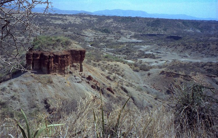
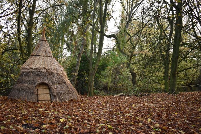
Rising to nearly 6,000 feet above sea level, Mount Homa dominates a Kenyan landscape that features sediments as old as the Miocene epoch — a geologic time period that ended more than 5 million years ago. This mountain’s real name, however, is Got Uma or God Marahuma, meaning “famous mountain,” bestowed by the Luo fishing people who have inhabited the surrounding region for centuries. Considered an inactive volcano, Got Uma, or Mount Homa, defines its namesake Peninsula, which extends into Africa’s massive Lake Victoria and helps to define the lake’s Winam Gulf, which laps the peninsula’s shoreline from the north. Though the peninsula, like anywhere else, has a regional and local natural and cultural history that extends back thousands of years, its most recent claim to fame lies in ancient sediments featuring a rich array of fossils that have drawn paleontologists, geologists, archaeologists, and many other scientists to explore and study a remarkable mosaic of prehistory. It is a mosaic that has also included evidence of a hominin presence — deep-time human relatives that have long become extinct.
Archaeologist Tom Plummer, Professor of Anthropology at Queens College, City University of New York, has been conducting field research on the Homa Peninsula since the 1990’s. Among other things, a record of significant fossil finds of Theropithecus oswaldi monkeys drew him and others to the area, as fossils of these monkeys have historically been frequently found near fossil evidence of hominins. Together with Richard Potts, who directs the Human Origins Program at the Smithsonian’s National Museum of Natural History, along with a team of other scientists and universities, he has uncovered robust evidence for hominin activity as far back as over 2 million years ago at key locations across this landscape.
One of the first “eureka moments” of these discoveries emerged at a place on the northwestern shore of the peninsula.
________________________________
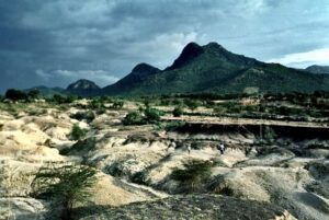
View of Mount Homa and surrounding landscape where investigations have taken place. Chip Clark (Smithsonian Institution), Public Domain
________________________________
Toolmaking and Butchery at Kanjera South
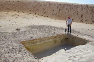
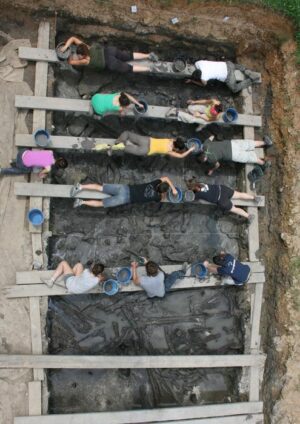
Early on, Plummer and a team of scientist specialists and excavators began investigating a site designated as Kanjera South, located near the margins of what was, at one time, an ancient lake. Digging methodically through fossil-bearing silts and fine sands, they penetrated several meters of sediment. In the process, they encountered stone artifacts and associated fauna, all revealed within three major beds. (A “bed” being a layer with a defined sequence of related or associated geologic events and fossil occurrences, such as what were initially described in excavations at Olduvai Gorge.) One 169-square meter excavation area alone yielded about 3,700 animal fossils and 2,900 artifacts in a sequence measured 1 meter in depth. Stone artifacts found during the excavation represented, according to Plummer, “one of the largest collections of Oldowan artifacts”* found to date, from anywhere in the world. The first Oldowan stone tools were discovered by archaeologist Louis Leakey in the 1930s at Olduvai Gorge. This very early technology usually consisted of simple cores, choppers, scrapers, awls and burins made of quartz, quartzite, basalt, obsidian, flint and chert. Early humans produced them by striking a core stone on the edge with a hammerstone to produce a conchoidal fracture with sharp edges and flakes that could be used for a variety of functions, such as cutting meat. Unmodified pieces, called manuports — stones transported from other locations — have also been found at some sites. Though the quantity and concentration of the Kanjera South finds at this location was significant, it was not altogether precedent-setting, because the Oldowan stone tool industry is considered, Plummer saya, “the oldest geographically widespread and long-lasting technology.”
_______________________________
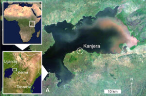
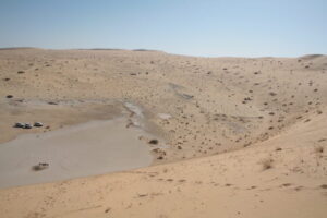
Location of Kanjera along the modern shoreline of Lake Victoria, East Africa. Joseph V. Ferraro, Thomas W. Plummer, Briana L. Pobiner, James S. Oliver, Laura C. Bishop, David R. Braun, Peter W. Ditchfield, John W. Seaman III, Katie M. Binetti, John W. Seaman Jr, Fritz Hertel, Richard Potts, Creative Commons Attribution 4.0 International, Wikimedia Commons
_______________________________
_______________________________
But there was more.
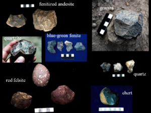
Notable from their analysis of the Oldowan artifacts, Plummer and colleagues observed that they had been fashioned from a great variety of raw material sources, including not only local sources of carbonate, limestone, iolite, nephelinite, and fenitized stone, but also from non-local, more remote sources for the quartzite, rhyolite, granite, basalt, and schistose stone. This led to an interesting implication. As stated by Plummer in a 2012 article published in Popular Archaeology Magazine:
“What we found is that approximately 30% of the artifacts recovered from Kanjera were made from rocks that were transported to the site from conglomerates at least 10-13 km away (Braun et al., 2008)…The finding that there are not nearly enough cores to account for all of the flakes at the site further hints that the artifact sample at Kanjera was part of a larger transport system. It appears that cores were being carried by hominins, for use to dispense flakes…”*
In this sense, the Kanjera site is unusual compared to other Oldowan sites in East Africa and elsewhere.
“The fact that hominins were investing energy in the transport of hard raw materials, and more efficiently reducing them, suggests that artifact manufacture was of great importance in their day-to-day lives,” wrote Plummer in The Hard Stuff of Culture.*
But why?
Analysis of the faunal remains at the site has given some clues. The site investigators recorded a comparatively significant number of associated bones of small antelopes about the size of or slightly larger than today’s Grants Gazelles. Bone type representation accumulated at the location suggested complete carcasses were brought to the site. Moreover, use-wear analysis of the associated artifacts, as well as damage analysis of the bones, indicated intentional cut-marks using the stone tools.
“Damage to the fossils indicates that hominins were using stone tools to slice meat off of bones, and to break bones open for their fatty marrow,” wrote Plummer.* Carnivore toothmarks were also found on the bones but most of those marks were made after the cut marks, suggesting carnivore scavenging after the hominins had completed processing the carcasses.
“The overall pattern of hominin access to the complete carcasses of small antelopes may be the signal of hominin hunting,” suggests Plummer. “If so, this would be the oldest evidence of hunting to date in the archaeological record.”[statement made based on fossil and artifact discoveries made as documented in the record by 2015]*
Moreover, use-wear analysis of the artifacts also suggested that these hominins were not limited to a carnivorous diet. They were processing a variety of plant tissues, including tubers and wood.
A new window on early hominin behavior was beginning to emerge.
____________________________
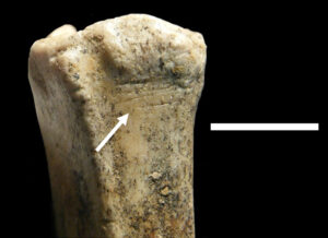
A small bovid metatarsal, bearing cut marks; from bed KS-2 of Kanjera, an archaeological and paleoanthropological site on the southern shores of the Winam Gulf of Lake Victoria, Homa Bay County, Kenya (scale: 1 cm). Joseph V. Ferraro, Thomas W. Plummer, Briana L. Pobiner, James S. Oliver, Laura C. Bishop, David R. Braun, Peter W. Ditchfield, John W. Seaman III, Katie M. Binetti, John W. Seaman Jr, Fritz Hertel, Richard Potts. Creative Commons Attribution 4.0 International, Wikimedia Commons
____________________________
A small bovid femur with numerous cut marks. From bed KS-2 of Kanjera. Joseph V. Ferraro, Thomas W. Plummer, Briana L. Pobiner, James S. Oliver, Laura C. Bishop, David R. Braun, Peter W. Ditchfield, John W. Seaman III, Katie M. Binetti, John W. Seaman Jr, Fritz Hertel, Richard Potts. Creative Commons Attribution 4.0 International, Wikimedia Commons
____________________________
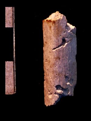
A shaft fragment from an ungulate leg bone showing a single, deep stone tool cutmark and carnivore toothmarks. One toothmark overlays the cutmark, indicating that the hominins had stripped meat off the bone prior to carnivore gnawing. Photo credit: Tom Plummer. See The Hard Stuff of Culture: Oldowan Archaeology at Kanjera South, Kenya, by Tom Plummer, Popular Archaeology, May 30, 2016.
____________________________
Retiming the Horizon at Nyayanga
While the discoveries and implications of Kanjera South were remarkable enough, Plummer and his colleagues soon found that there was much more to add to the story when they turned their attention to other sites west and south of Kanjera. Those efforts included a site known as Nyayanga (named after a nearby beach), located in the foothills of Mount Homa, a few hundred meters from the Lake Victoria shoreline.
It came on a personal referral. “Peter Onyango, one of the excavators working with us [at Kanjera South], told us that there were tools and fossils like we were finding at Kanjera near his home at a place called Nyayanga,” said Plummer. “So he showed us the place, and we began to research the exposures there.”
Plummer knew he faced a few given complications with the site location. “Because the area is densely populated with people and livestock, trampling can damage and disperse bones and stone tools as they erode out of the outcrop,” he explained. “Also, heavy rain during the wet season(s) can rapidly erode sediments of interest and wash away important fossils and artifacts.”
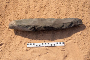
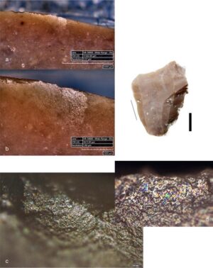
With these challenges, excavations began in earnest in 2015. Digging in 1 meter squares, they recorded and mapped all objects and fossils measuring greater than 2 centimeters with a laser theodolite. “All of the artifacts from the most ancient sediments at Nyayanga (Nyayanga Beds 1-4) were Oldowan tools,” said Plummer. The team recovered a total of 330 identifiable Oldowan artifacts, 195 from the surface and 135 in situ within the stratigraphic context. Although the assemblage was generally similar to those found at other locations, this one was distinctly characterized with a high frequency (20.6 %) of cores and a comparatively larger percentage of artifacts showing signs of percussive activity. The tools were manufactured from a variety of different raw materials, including quartz, quartzite and rhyolite.
A total of 1,776 bones were recovered and recorded, combined from two excavations (excavations 3 and 5). A large percentage of the bone remains were attributed to hippopotamids (hippos) at 57.1% and 61.9 %, respectively. Most significantly, Plummer’s team detected clear evidence of butchery among these large fauna. At least two hippos were recovered from excavation 3, the bones of one individual hippo associated with as many as 42 stone tools, including several in direct physical contact with the bones. One rib fragment featured a clear cut-mark with characteristics typically made by a stone tool, and three stone flakes exhibited use-wear patterns identifiable to butchery activity. In excavation 5, another array of bones attributable to a single individual hippo were recovered in association with 14 stone tool artifacts. Faunal remains of other animals were also found showing clear damage attributable to stone tools. Evidence pointed to hominin consumption of both meat and bone marrow.
But stone tool use was not confined to butchery activity at the site. “Our team’s analyses of stone tool butchery marks on fossils, and microscopic wear formed on stone tools used to cut and pound things, indicate that a diverse array of plant and animal foods was acquired and processed by the Nyayanga toolmakers,” says Plummer. The hominins who occupied the site, in other words, did not subsist entirely on megafauna. They had a diverse diet.
Moreover, analysis of soil carbonates, tooth enamel isotopes, and taxon in the area indicated that these hominins subsisted in a grassy woodland consisting of warm-season grasses along a stream channel and fresh-water springs within an overall savannah-like environment, a setting not unlike those found at other Oldowan sites such as Ledi-Geraru and Mille-Logya in Ethiopia. Such a habitat would have provided the hominins at this location with a diverse range of potable water, animal and plant food sources, and shelter.
What stood out most from the finds at Nyayanga, however, revolved around three eye-brow raising discoveries — the date range of the finds, the hominin fossil evidence, and the location of the finds…
______________________________
Read the complete article with Popular Archaeology premium.
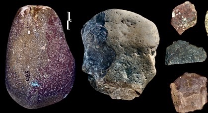
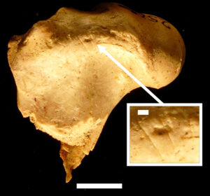
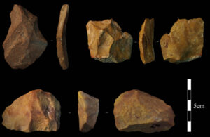
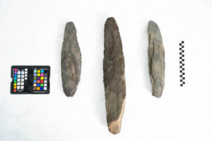
Cover Image, Top Left: Examples of an Oldowan percussive tool, core and flakes from Nyayanga. T.W. Plummer, J.S. Oliver, and E. M. Finestone, Homa Peninsula Paleoanthropology Project
______________________________
Advertisement

EXPLORE THE ANCIENT ETRUSCANS IN PERSON!
Experience a unique, up-close-and-personal hike among ancient hilltop towns in central Italy. You will walk the sensational countryside of the regions of Umbria and Tuscany, soaking in important sites attesting to the advanced Etruscan civilization, forerunners of the ancient Romans; imposing architectural and cultural remains of Medieval Italy; local food and drink; and perhaps best of all — spectacular scenic views! Join us in this collaborative event for the trip of a lifetime!


.jpg)