Across the broad, wheat-gilded plateau of the Tavoliere di Puglia, between the foothills of the Apennines and the Adriatic horizon, an ancient city lies mostly buried and largely forgotten. Herdonia—called, with both admiration and melancholy, ‘la Pompei di Puglia (Pompeii of Puglia)’—witnessed the catastrophe of Cannae, the armies of Hannibal, the glory of Trajan’s highway (Via Traiana), the slow twilight of late antiquity, and the hunting lodges of the Holy Roman Emperor Frederick II of Swabia.
Only twenty per cent of its twenty-hectare urban fabric has been investigated in six decades of intermittent excavation, and the remaining eighty per cent still waits, intact, beneath the thin Puglian soil. This article synthesizes the full arc of research at Herdonia—from its Daunian origins in the Iron Age through the most recent initiatives for its recovery as a public archaeological park—and makes the case for the site’s singular importance to the archaeology of ancient Italy.
The Tavoliere in Time: a Landscape of Deep Memory.
Few regions of the Italian peninsula have been inhabited as continuously, and as consequentially, as the Tavoliere di Puglia. This vast alluvial plain in northern Puglia—the ancient territory of Daunia—extends roughly between the Gargano promontory to the northeast and the foothills of the sub-Apennine zone to the west, bisected by the rivers Carapelle, Cervaro, Fortore, and Ofanto.
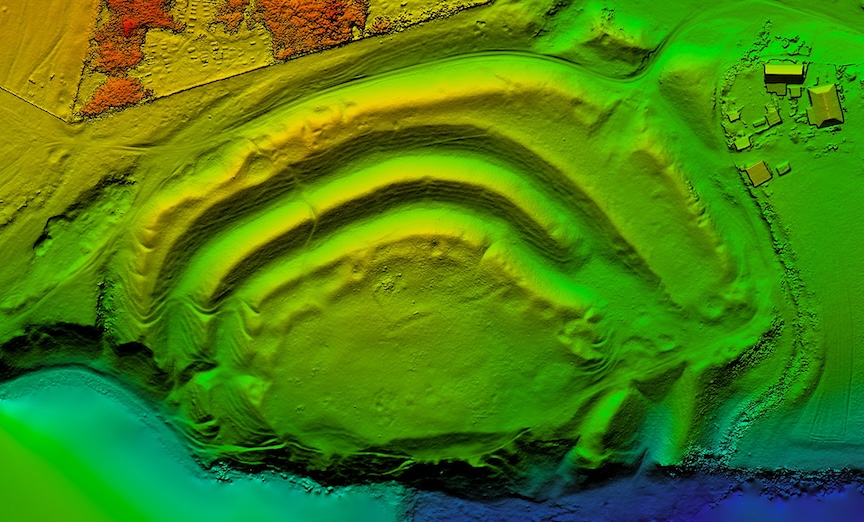
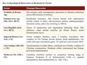
It is one of the oldest farmed landscapes in Europe: the Neolithic enclosures of the Tavoliere, visible in aerial photography as concentric ditched circuits, are among the earliest evidence of sedentary agriculture in the western Mediterranean, dating back to the seventh and sixth millennia BCE. From this deep agrarian substrate, the cultural identity of Daunia would eventually crystallize.
It was within this landscape that the Daunian people—one of the ancient Italic peoples of the region—established a distinctive civilization during the Iron Age and Archaic periods (ca. eleventh to fourth centuries BCE).
Their material culture is among the most visually arresting in pre-Roman Italy: painted sub-Geometric and Geometric pottery, distinctive anthropomorphic grave stelae—the so-called stele daunie—carved from local limestone and erected over elite burials, their incised geometric decoration suggesting a world of warriors, supernatural creatures, and aristocratic feasting.
___________________________

Tavoliere di Puglia. (CREDITS: ORDONA’S HERMA – HERDONIA ARCHAEOLOGICAL MUSEUM)
___________________________
These stelae, many of which were recovered from the necropolis of Herdonia and its surrounding territory, stand today among the masterpieces of pre-Roman Italian art, displayed in the museums of Foggia, Bari, and Taranto, and—following a celebrated repatriation funded by a public subscription coordinated by the Apulia Felix Foundation—in the Herdonia Archaeological Museum (HerMA) at Ordona.
The ancient city of Herdonia occupies a low hillock to the southwest of the modern town of Ordona, in the province of Foggia. The site was enclosed by a perimeter wall approximately 1,980 meters in length, defining an elongated rectangular urban area roughly 730 meters north-to-south and 300 meters east-to-west — nearly twenty hectares in extent.
Within this circuit, three low hills, flattened at their summits and separated by shallow valleys where the city’s gates once stood, formed the topographic skeleton of an urban landscape that endured, in one form or another, for more than fifteen hundred years.
____________________________
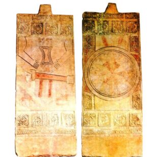
Herdonia’s Stelae Daunie. (CREDITS: ORDONA’S HERMA – HERDONIA ARCHAEOLOGICAL MUSEUM)
____________________________
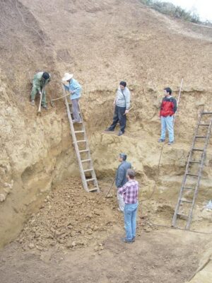
The modern rediscovery of Herdonia is, by any measure, one of the great adventure stories of post-war Mediterranean archaeology. In November 1962, the Belgian archaeologist and architectural historian Joseph Mertens at the Institut Historique Belge of Rome initiated systematic excavations on a hillock that local inhabitants had long known harbored ancient remains. What unfolded over the following three decades would transform understanding of Roman urbanism in southern Italy.
Mertens’ team worked with remarkable methodological rigor for its era, employing stratigraphic analysis, detailed architectural documentation, and — crucially — aerial photography, which had first revealed the ghostly plan of the ancient city from altitude, its walls and street grid etched into the cereal crops by differential moisture retention. The Belgian mission excavated in continuous campaigns until 1992, and the results were published in an exemplary series of monographs—Ordona I through IX and beyond—that remain foundational references for scholars of Roman Puglia to this day.
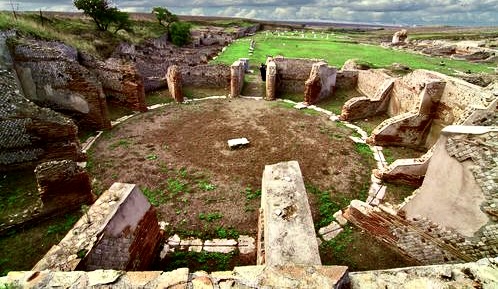
By the time the Belgian campaigns concluded, archaeologists had brought to light the essential skeleton of Herdonia’s public urban core: the perimeter walls with their gates and flanking towers finished in opus reticulatum; a monumental forum complex with its civic basilica, senate house (curia), and two temples; a circular covered market (macellum); commercial taverns (tabernae); an elaborate bath complex aligned along the Via Traiana; and, to the northeast of the city, the modest but archaeologically significant remains of a small amphitheater—built, in a detail emblematic of the layered palimpsest that makes Herdonia so compelling, directly over a pre-existing Daunian defensive ditch.
Surrounding the walls, an extensive necropolis yielded hundreds of burials spanning the Daunian through late Roman periods, with grave goods now distributed across several Italian museums. The monumental publications of the Belgian mission, culminating in Mertens’ definitive study of 1995, followed by the continuing Ordona series, established Herdonia as a key reference site for the study of Italic and Roman urbanism. Mertens himself became one of the most respected figures in the archaeology of Roman Italy, and his loss to the scholarly community was deeply felt when he passed away after decades of productive engagement with the site.
The Discovery of a City: Joseph Mertens and the Belgian Mission (1962–1992)
The modern rediscovery of Herdonia is, by any measure, one of the great adventure stories of post-war Mediterranean archaeology. In November 1962, the Belgian archaeologist and architectural historian Joseph Mertens at the Institut Historique Belge of Rome initiated systematic excavations on a hillock that local inhabitants had long known harboured ancient remains. What unfolded over the following three decades would transform understanding of Roman urbanism in southern Italy.
Mertens’ team worked with remarkable methodological rigour for its era, employing stratigraphic analysis, detailed architectural documentation, and — crucially — aerial photography, which had first revealed the ghostly plan of the ancient city from altitude, its walls and street grid etched into the cereal crops by differential moisture retention. The Belgian mission excavated in continuous campaigns until 1992, and the results were published in an exemplary series of monographs—Ordona I through IX and beyond—that remain foundational references for scholars of Roman Puglia to this day.
By the time the Belgian campaigns concluded, archaeologists had brought to light the essential skeleton of Herdonia’s public urban core: the perimeter walls with their gates and flanking towers finished in opus reticulatum; a monumental forum complex with its civic basilica, senate house (curia), and two temples; a circular covered market (macellum); commercial taverns (tabernae); an elaborate bath complex aligned along the Via Traiana; and, to the northeast of the city, the modest but archaeologically significant remains of a small amphitheatre—built, in a detail emblematic of the layered palimpsest that makes Herdonia so compelling, directly over a pre-existing Daunian defensive ditch.
Surrounding the walls, an extensive necropolis yielded hundreds of burials spanning the Daunian through late Roman periods, with grave goods now distributed across several Italian museums. The monumental publications of the Belgian mission, culminating in Mertens’ definitive study of 1995, followed by the continuing Ordona series, established Herdonia as a key reference site for the study of Italic and Roman urbanism. Mertens himself became one of the most respected figures in the archaeology of Roman Italy, and his loss to the scholarly community was deeply felt when he passed away after decades of productive engagement with the site.
__________________________

The Forum of Herdonia. (CREDITS: ORDONA’S HERMA – HERDONIA ARCHAEOLOGICAL MUSEUM)
__________________________
The Italian Mission and the Unveiling of a Complete Urban History (1993–2000)
In 1993, a new chapter began at Herdonia. An Italian team from the University of Bari, directed by Giuliano Volpe—a scholar who would go on to serve as Chancellor of the University of Foggia—joined the ongoing Belgian excavations, establishing a collaborative Belgian-Italian mission. For seven years, the joint team excavated in a spirit of methodological innovation that brought Herdonia into the forefront of Italian field archaeology.
The Italian campaigns yielded results of exceptional significance across multiple historical periods. Among the most important discoveries of the 1993–2000 seasons was the full exposure and analysis of the great bath complex along the Via Traiana—a building of imperial and late antique date featuring a succession of hot and cold rooms richly adorned with colored marble revetments and mosaic floors.
The baths, which had first been partially investigated by the Belgian team in the 1970s, proved far more extensive than previously recognized, and their stratigraphic sequence provided a detailed narrative of the city’s development from the High Empire through the early mediaeval period.
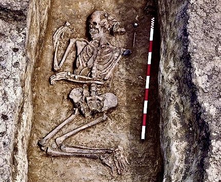
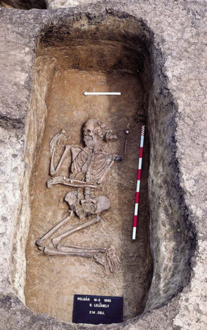
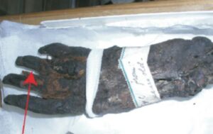
The Italian mission also undertook extensive investigation of the Daunian levels of the site, recovering evidence for the pre-Roman city in a detail that substantially revised understanding of Herdonia’s origins. Excavations in the area of the amphitheater—a structure built over an earlier Daunian ditch—revealed that the site had been occupied continuously from the Iron Age onwards, with clusters of domestic structures, abundant ceramics, and elaborate burial assemblages testifying to a prosperous Daunian community from the ninth or eighth century BCE.
The pottery, including the characteristic sub-Geometric painted wares, for which Daunian craftspeople are celebrated, found parallels across the wider Daunian cultural sphere and enabled refined chronological sequences. The discovery that proved most arresting for public imagination, however, was a textile of exceptional antiquity found associated with a warrior burial.
A combination of over three hundred individual fragments—seventy pieces of woven fabric, twenty-nine of wood, two hundred and fifty of bronze laminate, and four turned objects—yielded, after a full year of painstaking laboratory analysis, a parade panoplia whose embroidered borders constitute the oldest recovered textile embroidery in all of Italy.*
The warrior of Herdonia, as the assemblage became known, attracted international scholarly attention and offered a vivid window into the material culture and social hierarchies of the Daunian elite.
_____________________________
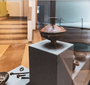
some Daunian potteries of Ordona’s archaeological site museum. (CREDITS: ORDONA’S HERMA – HERDONIA ARCHAEOLOGICAL MUSEUM)
_____________________________
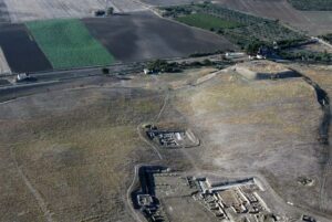
_____________________________

Aerial view of Herdonia excavated zone (Ordona, FG) (CREDITS: ORDONA’S HERMA – HERDONIA ARCHAEOLOGICAL MUSEUM)
_____________________________
Herdonia Between Hannibal and Rome: the Trauma of the Punic Wars
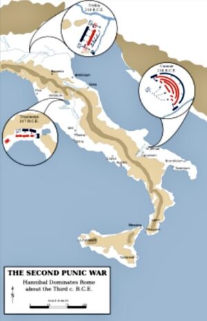
The Battle of Cannae during the Second Punic War.
Herdonia’s fate during the Second Punic War (218–201 BCE) illuminates with particular clarity the dangers confronting communities caught between superpowers in the ancient world — and the long institutional memory of the Roman state. Following the catastrophic Roman defeat at the Battle of Cannae in 216 BCE, fought on the banks of the Aufidus (modern Ofanto River) some thirty kilometers from Herdonia, the political landscape of Puglia was shattered.
Entire communities revised their allegiances; Herdonia was among those that transferred their loyalty from Rome to Hannibal. The consequences were momentous. In 212 BCE, on the plains outside the city, Roman forces under the praetor Gnaeus Fulvius Flaccus were ambushed and annihilated by Hannibal’s army in what ancient sources record as one of Rome’s most humiliating reversals of the war—the First Battle of Herdonia.
A second engagement followed in 210 BCE, again resulting in a Carthaginian victory, this time under the Samnite commander Hanno: when Rome ultimately prevailed, its reckoning with those communities that had sided with Carthage was systematic and unforgiving. The population of Herdonia was deported—ancient sources speak of transportation to Metapontum and Thurii, cities on the Gulf of Taranto—and the city was effectively razed or severely damaged. Excavations have confirmed this traumatic rupture in the archaeological record: destruction layers, abandoned structures, and a perceptible hiatus in material culture all testify to the violence of Rome’s retribution.
Yet Herdonia survived, and its subsequent history offers a remarkable story of recovery and reinvention. By the early imperial period, the city had been refounded as a Roman municipium, its urban grid reorganized, and its public architecture rebuilt on an ambitious scale. The very Via Traiana—built by the emperor Trajan between 108 and 114 CE to provide a more efficient route between Beneventum (Benevento) and Brundisium (Brindisi), replacing the older Via Minucia—ran directly through the heart of Herdonia, connecting it to the arterial infrastructure of the Empire and ensuring its continued commercial significance.
Ruts worn by generations of wheeled traffic are still visible today in the ancient paving stones of the Via Traiana as it traverses the archaeological site — one of the most viscerally immediate connections between the modern visitor and the life of Roman Italy available anywhere in the peninsula.
______________________________
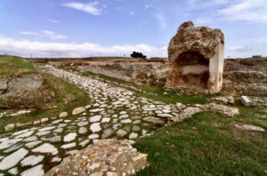
Herdonia’s several surviving paving stones of the Via Traiana. CREDITS: ORDONA’S HERMA – HERDONIA ARCHAEOLOGICAL MUSEUM)
______________________________
Anatomy of a Roman City: the Public Architecture of Herdonia
At the heart of Herdonia’s excavated urban zone lies its forum — the civic and commercial nucleus that gave expression to the city’s identity as a Roman municipium. The forum complex conforms broadly to the canonical layout of Italian fora of the late Republican and imperial periods: a large open plaza, flanked on multiple sides by porticoed walkways, with major civic buildings disposed around its perimeter.
Two temple podia rise from the western edge of the forum, their orientation and alignment suggesting dedications consistent with the principal deities of the Roman state pantheon, though firm epigraphic confirmation remains elusive. A civic basilica—the multipurpose hall that served simultaneously as law court, commercial exchange, and public assembly space—closes one end of the plaza, its apses and nave still partially standing to a height that offers a visceral sense of the original interior volume.
The senate house (curia decurionum), where the local governing council of elected magistrates met, adjoins the basilica complex. The macellum, or covered market, takes the form characteristic of Italian markets of the imperial period: a circular or polygonal central tholos surrounded by a ring of commercial tabernae, the whole enclosed within a colonnade.
_________________________
Herdonia’s local market, the Roman macellum. (CREDITS: ORDONA’S HERMA – HERDONIA ARCHAEOLOGICAL MUSEUM)
_________________________
A series of tabernae also lines the forum porticoes, their standardized proportions and door-sill grooves evoking the commercial vitality of a prosperous agricultural city at the intersection of major road networks. Epigraphic evidence — building dedications, honorific inscriptions for imperial family members, and municipal decrees recorded on bronze — attests to the active civic culture of Herdonia’s governing class through the first and second centuries CE.
The great bath complex of Herdonia, excavated in its northern extent by the Belgian mission and substantially completed by the Italian campaigns of 1993–2000, represents the most architecturally elaborate structure yet revealed at the site. Located immediately south of the Via Traiana, whose ancient paving runs visibly through the excavated area, the baths follow the standard sequence of imperial thermae: an undressing room (apodyterium), cold hall (frigidarium) with plunge pool, warm room (tepidarium), and hot room (caldarium) with hypocaust underfloor heating.
__________________________
Herdonia’s bath complex of the final excavated thermae. (CREDITS: ORDONA’S HERMA – HERDONIA ARCHAEOLOGICAL MUSEUM)
__________________________
The decorative program – colored marble revetments, polychrome mosaic floors, painted stucco – reflects the wealth of a city whose economy was firmly grounded in the agricultural surplus of the Tavoliere and the transit commerce of the road network. The baths remained in use through the late antique period, their phased rebuilding and decorative renovation documenting Herdonia’s continued vitality well into the fifth and sixth centuries CE, at a time when many comparable cities of Roman Italy were experiencing contraction.
A stratigraphic sequence of eight or more construction and renovation phases has been identified within the bath complex alone, making it among the best-documented examples of long-term architectural continuity at any site in southern Italy.
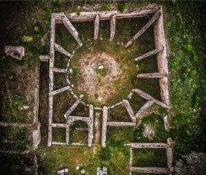
Northeast of the forum, the remains of Herdonia’s amphitheater survive in partial form: while modest in scale compared to the great arenas of Campania or Capua, the structure is of singular archaeological interest for its stratigraphic position: it was constructed directly over a pre-existing Daunian defensive ditch, whose fill layers contained abundant Iron Age material. The amphitheater thus embodies in physical form the historical transition from Daunian Herdonia to Roman Herdoniae—the new Roman civic institution literally grounded upon the remains of the pre-Roman city.
__________________________

Herdonia’s ruins of the Roman amphitheater. (CREDITS: ORDONA’S HERMA – HERDONIA ARCHAEOLOGICAL MUSEUM)
__________________________
Post-Roman Herdonia: the Mediaeval City and the Legacy of Frederick II
The abandonment of Herdonia was not sudden. Late antique transformations of the urban fabric — the conversion of forum spaces, the shrinkage of monumental building programs, the encroachment of agricultural or domestic structures into formerly public zones — are well documented archaeologically and conform to patterns observed across dozens of comparable sites in the Roman West. What distinguishes Herdonia is the remarkable longevity of its mediaeval occupation.
During the early mediaeval period, a nucleated settlement — the castellum — developed on the city’s acropolis, making use of the high point that dominates the three hills enclosed within the ancient walls. This fortified nucleus was surrounded by a defensive ditch and enclosed a series of late mediaeval structures whose plan is still partially legible from the surface. It was in this mediaeval context that Herdonia achieved one final moment of prominence in the historical record.
Frederick II of Hohenstaufen—Holy Roman Emperor, King of Sicily, King of Jerusalem, Stupor Mundi (Wonder of the World) to his admirers and Antichrist to his enemies—established a hunting lodge at or near the mediaeval castellum of Herdonia in the thirteenth century. Frederick’s passion for falconry and the hunt was a defining element of his public persona; his great ornithological treatise, De Arte Venandi cum Avibus (On the Art of Hunting with Birds), written in the 1240s, remains a foundational text of mediaeval natural history.
The presence of an imperial hunting lodge at Herdonia—as at nearby Pantano in the territory of Luceria, where excavations directed by Giuliano Volpe’s team revealed the remains of Frederick’s zoo and garden—attests to the deliberate imperial choice to locate these retreats in the agriculturally productive lowlands of Puglia, whose open plains offered ideal terrain for coursing and hawking.
By the fourteenth or fifteenth century, Herdonia was definitively abandoned. The slow attrition of population that had characterised the late mediaeval Tavoliere—itself a consequence of the plague, agricultural crisis, and political instability that afflicted the kingdom of Naples—finally extinguished the millennium-and-a-half of continuous urban life at the site. The modern community of Ordona developed nearby, first as a Jesuit agricultural estate and subsequently as one of the new royal colonial settlements established by Ferdinand IV of Bourbon in the late eighteenth century to repopulate the depopulated Tavoliere.
___________________________

Portrait of Frederick II of Swabia. (CREDITS: ORDONA’S HERMA – HERDONIA ARCHAEOLOGICAL MUSEUM)
___________________________
The Interrupted City: a Crisis of Stewardship (2000–2022)
The year 2000 brought the abrupt and entirely unforeseen suspension of all fieldwork at Herdonia. The cessation was caused not by scholarly decision or budgetary constraint but by a protracted legal dispute between the Italian state heritage agency (then MiBACT, now MiC — Ministero della Cultura) and the private landowners on whose property the ancient city stood.
The Cacciaguerra family, which had owned the farmstead and land at the site for generations, and the state found themselves locked in litigation over the terms of compulsory purchase — a procedure mandated by Italian cultural heritage law for sites of declared national importance but one whose execution in this case proved extraordinarily protracted.
The consequences for the site were severe: monuments that had been excavated, conserved, and stabilized over decades were left without maintenance or protective covering. Vegetation—the rank scrub of the Puglian lowlands—progressively reclaimed the exposed walls, mosaic floors, and stucco surfaces. Restored frescoes, exposed to rain and sun without protection, deteriorated rapidly.
Interpretive panels installed by the Italian team during the 1990s, once designed to welcome and educate visitors, weathered beyond legibility. The site, which had served for nearly four decades as a flourishing teaching excavation where successive generations of Belgian, Italian, and international archaeology students received field training, fell effectively silent.
The scholarly community did not, however, abandon the site. Research continued through the analysis of already-excavated materials and the application of digital archaeology: GIS mapping, three-dimensional reconstructions, photogrammetric documentation of extant remains, and the systematic publication of unpublished finds. The monograph series Ordona—the thirteenth volume of which appeared in 2021—continued to provide a vehicle for ongoing scientific communication.
A landmark digital archaeology initiative summarized as Ordona XIII (2021) brought together twenty years of post-excavation research and established Herdonia as one of the best-documented, if least-visited, Roman cities in southern Italy.
The human cost was also visible. The site’s de facto custodian, Ambretta Cacciaguerra, maintained the archaeological area at her family’s expense, organizing civic volunteers to clear vegetation, welcoming visitors, representing the site at archaeological fairs and cultural events, and lobbying tirelessly for its recovery.
Her commitment — born of long familiarity with the excavations and deep attachment to the place — exemplifies the kind of civic archaeology that sustains Italian heritage sites in periods of institutional failure.
____________________________

____________________________
Towards Recovery: New Initiatives and the Prospect of a Renaissance 2014–2025
The long-awaited turn in Herdonia’s fortunes began in 2014, when the Ministry of Cultural Heritage succeeded in acquiring a portion of the privately held land. A further and decisive step came in May 2022, when the ministry completed the acquisition of the remaining parcels, removing the principal legal obstacle to renewed fieldwork and large-scale conservation. The formal legal confirmation of state ownership was underscored by the intervention of President of the Republic Sergio Mattarella, whose rejection of a final appeal by the landowners definitively established the entire twenty-four-hectare archaeological zone as public property. The acquisitions opened the way for substantial investment.
Under the CIS Capitanata (Contratto Istituzionale di Sviluppo)—an instrument for coordinated public investment in southern Italy—a project for the restoration and valorization of the central area of Herdonia received funding of one million euros. A further allocation of 1.7 million euros from the Ministry of Culture followed through the regional Secretariat of Puglia, which assumed the role of contracting station for the project. These resources were directed toward conservation of exposed monuments, improvement of site access, connection to the adjacent HerMA museum, and the creation of infrastructure for sustainable public use.
In March 2024, the Soprintendenza Archeologia Belle Arti e Paesaggio for the Provinces of Foggia and BAT, in collaboration with the Municipality of Ordona and the University of Foggia’s Department of Human Studies, organized a participatory planning event, entitled “Paesaggio e Archeologia: Herdonia e l’Area del Castellum Medievale”, which presented to the local community two major valorization projects: the Appia Viarum initiative—which proposes to integrate Herdonia into a cultural landscape itinerary along the ancient Via Traiana, connecting it to the Roman bridge at Ponte Rotto on the Cervaro and the Roman bridge on the Carapelle—and the CIS Capitanata ‘Parco Archeologico di Herdonia’ project.
The participatory dimension of the event reflected a deliberate commitment to community engagement as a foundational principle of any viable heritage recovery. In May 2024, the Italian parliament received a formal announcement from the Undersecretary of Culture, Gianmarco Mazzi, that the administrative procedure for formal expropriation of any remaining contested parcels was underway and that the completion of state ownership would enable a unified master plan for the archaeological park.
The announcement followed an interrogation by Senator Anna Maria Fallucchi concerning the status of the long-delayed project — evidence that Herdonia’s fate had become, at last, a matter of national political attention. Parallel to these institutional developments, a remarkable collaboration between the Ministry of Culture’s Puglia Regional Secretariat, the Soprintendenza, and the Department of Architecture, Construction and Design (ArCoD) of the Politecnico di Bari has produced a comprehensive programme of advanced digital documentation.
By using laser scanning, drone-based photogrammetry, and structured light scanning, Politecnico students and faculty have generated a complete three-dimensional model of Herdonia’s excavated remains—the first time in the site’s sixty-year research history that a truly exhaustive topographic and architectural record has been achieved. This digital baseline will serve as the foundation for all future conservation, design, and interpretive interventions.
A crucial element of the emerging archaeological park infrastructure is the Herdonia Museo Archeologico (HerMA), inaugurated in 2017 in the town of Ordona, a few hundred meters from the ancient city.
____________________________

Herdonia’s Archaeological Museum (HerMA) inaugurated in 2017. (CREDITS: ORDONA’S HERMA – HERDONIA ARCHAEOLOGICAL MUSEUM)
____________________________
The museum represents the first purpose-built facility to serve the interpretation of Herdonia’s long history, providing a permanent home for the thousands of objects recovered during sixty years of excavation and now, for the first time, organised within an accessible, professionally curated display framework. Among the museum’s most celebrated holdings are examples of Daunian painted pottery — the extraordinary sub-Geometric and Geometric vessels that rank among the finest products of pre-Roman Italian ceramics.
The museum also displays the Daunian stele recovered from the local area, including one exceptional limestone funerary monument repatriated through public subscription after it appeared at auction at the Bertolami Fine Arts house — a recovery coordinated by the Fondazione Apulia Felix and its president, Giuliano Volpe, whose personal engagement with the cause attracted significant media attention and public generosity.
Roman material culture is represented across the full chronological range of the site’s occupation: Republican-period ceramics, bronze inscriptions, imperial-period sculpture fragments, decorative architectural elements from the forum and baths, and the hoard of 147 gold tarì and one Byzantine solidus discovered during the 1965 Belgian campaigns—a numismatic find of considerable rarity and scholarly importance, long held in the reserves of the Taranto Museum without public display.
HerMA also serves as the interpretive and educational hub for the proposed archaeological park, hosting temporary exhibitions, school programmes, and cultural events, including theatrical performances and historical reenactments of the Herdonia landscape.
Conclusions
Herdonia’s claim on international scholarly attention rests on several convergent arguments, each compelling in its own right, and together constituting a case for the site’s elevation into the first rank of Italian archaeological priorities.
First, Herdonia is one of the rare Italian cities of antiquity where the ancient urban fabric is not overlain by a living modern town. Unlike Capua, Benevento, Venosa, or Lucera—all of which preserve substantial ancient remains but whose investigation is complicated by their continuous habitation—Herdonia’s abandonment in the mediaeval period means that its Roman and pre-Roman stratigraphy is accessible across virtually its entire twenty-hectare extent.
The proportion of this area yet un-investigated — conservatively estimated at eighty percent, representing fifteen to sixteen hectares of intact deposits — constitutes a research archive of extraordinary potential. As Giuliano Volpe has observed, if forty years of excavation yielded four to five hectares of revealed urban fabric, the remaining unexplored areas represent, at comparable research intensity, more than a century of future discovery.
Second, Herdonia’s chronological depth is exceptional. The site documents human occupation from the Neolithic through the late mediaeval period—a sweep of roughly eight thousand years—in a landscape whose geological stability and agricultural productivity have largely preserved the stratigraphic record intact. Few Italian sites offer this combination of chronological range and physical accessibility.
Third, Herdonia’s position at the intersection of multiple road systems—the Via Traiana, the Via Eclanense, and the road to Venosa—made it a node of connectivity within the imperial road network and a point of cultural exchange between Rome and the eastern Mediterranean; its history of alternating alliances during the Punic Wars, its recovery under Roman administration, and its transformation through late antiquity and the mediaeval period offer a compressed narrative of the processes—Romanization, Christianization, and feudalization—that shaped the Italian south over two millennia.
Fourth, and perhaps most urgently for the present moment, Herdonia exists at a pivotal juncture in its modern history. The legal obstacles that prevented fieldwork and conservation for more than two decades have been substantially resolved. Public funds for conservation and site infrastructure are in place.
A coordinated planning process involving the Ministry of Culture, the local Soprintendenza, the municipalities of Ordona and the wider Daunia, the Universities of Foggia and Bari, and the Politecnico di Bari is underway. The scholarly community, represented by the continuing Ordona series and by active researchers at multiple institutions, stands ready to resume excavation. What Herdonia requires, above all, is sustained international attention and the kind of long-term institutional partnership that has transformed comparable sites — Pompeii, Herculaneum, Paestum — from imperiled ruins into world-class cultural destinations.
The field is open. Puglia’s lost city and Italy’s most neglected archaeological marvel is waiting.
_____________________________
Acknowledgments
The author acknowledges the vital contributions of the late Joseph Mertens to the study of Herdonia. Thanks are due to the community of Ordona—especially to Ambretta Cacciaguerra for her extraordinary custodianship of the site—to the Soprintendenza Archeologia of Foggia and BAT, and to the colleagues of the Universities of Foggia and Bari, the Politecnico di Bari and Fondazione Apulia Felix for their wonderful support.
_____________________________
Cover Image, Top Left: Scavi di Ordona, Nafta82, CC BY-SA 3.0, Wikimedia Commons