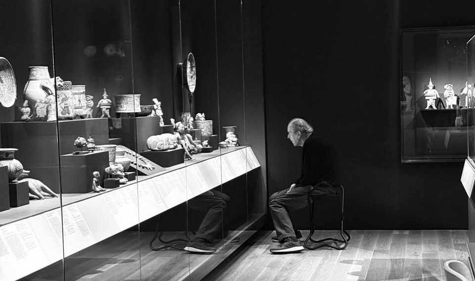
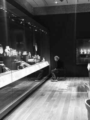
Here he is, sitting very close to the glass case. So close that only the glass remains between him and the objects — a thin, almost conditional boundary. His back is slightly hunched, his hands lowered, his legs placed calmly, like someone who did not intend to stay, but did.
In front of him are small ancient figures, vessels, fragments of bodies, fragments of ritual — fragments of time. They are arranged as interlocutors. There are many of them, they vary in scale, and each one requires a different kind of attention. He does not rush. His gaze settles. He sits as if engaged in a long conversation that began long before this evening.
In the reflection of the glass, his figure doubles. One version of him is present inside the newly opened galleries of the Princeton University Art Museum. The other appears inside the vitrine, among the artifacts. The reflection becomes part of the scene: the human body enters the exhibition, and the exhibition enters his memory.
_____________________________
A visitor contemplating the collection at the Princeton University Art Museum. Photo credit: Anastasia Adeler
_____________________________
At this moment, space functions directly.
Posture, distance, light, and time align.
Time loosens its linear grip and begins to behave differently.
This is where the new Princeton University Art Museum begins.
It begins with proximity.
With stillness.
With a person encountering objects that have endured beyond individual life, beyond era, beyond language.
This photograph holds the logic of a museum that has reopened after years of reconstruction as a space for human presence. What matters here is both what is shown and how one is allowed to occupy and move through the space.
I stood there longer than I expected. Watching him. Watching the way his body leaned toward the glass, the way time gathered around that small circle of attention. And only then did I realize that this was not the beginning of my experience in the museum. It was the point where everything I had already passed through slowly converged.
________________________
Before that moment, there was my physical approach.
The walk across campus at dusk — stone paths darkened by moisture, bicycles resting against iron railings, the Gothic silhouettes of Princeton receding into shadow. The museum revealed itself gradually. Not as an isolated object, but as part of the fabric of the place. A mural appeared first — graphic, deliberate, integrated into the exterior rather than applied to it. It signaled that this building was willing to speak visually, but without noise.
The entrance did not separate inside from outside abruptly. It eased you across that threshold. Glass, stone, wood guided the transition. The door opened into space rather than into a hall.
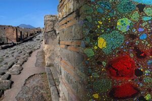
And then there was the floor.
Beneath glass, a Roman mosaic extended underfoot, not lifted onto a wall, not framed as a distant artifact. You walked over it, instinctively slowing down, adjusting your step. The museum established its relationship with the body immediately. History was not placed at eye level. It was placed where you stood.
____________________________
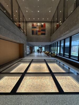
Photo credit: Anastasia Adeler
____________________________
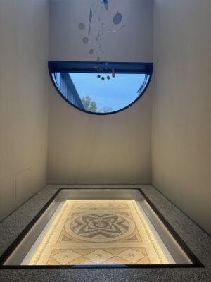
Photo credit: Anastasia Adeler
____________________________
The interior unfolded with restraint. Clean lines, careful proportions, surfaces that absorbed sound instead of reflecting it. The warmth of wood above balanced the coolness of stone and terrazzo below. Light entered from multiple directions, filtered, angled, never overwhelming. You could feel how much attention had been given to how the space would be used at different hours of the day.
As I moved inward, I noticed how the building avoided symmetry as a principle. Corridors shifted. Views opened sideways. Galleries revealed themselves in sequence rather than alignment. You were never placed on a single axis. You were always slightly off-center — a participant rather than an observer.
This design choice echoed what I would later see again and again: people inhabiting the museum rather than passing through it.
Someone sat near a window with a sketchbook.
Someone paused at the edge of a gallery, leaning lightly against the wall.
Someone stood alone, hands in pockets, looking upward.
The space accommodated these gestures naturally.
It was only later, standing in front of that vitrine, watching the man who had become part of the scene, that I understood how deliberately this experience had been shaped. The architecture had already taught me how to be there. How to slow down. How to stay.
That photograph, taken later, holds the result of this sequence.
But the sequence began the moment I stepped inside. Details begin to surface as you move deeper inside.
The staircases do not dominate the space. They appear when they are needed, widening slightly at landings, allowing people to pause without stepping aside. Railings feel measured to the hand. Steps carry a shallow rise that slows the body without announcing the intention. You become aware of your own pace through movement rather than instruction.
Walls hold their distance. Some surfaces come close, others pull back, creating a subtle play of compression and release. The proportions shift just enough to register in the body. You sense when a gallery is meant for standing, when for sitting, when for staying longer.
Furniture is sparse and precise. Chairs and benches appear near windows, beside thresholds, at the edges of rooms. They are aligned with views- sometimes inward toward objects, sometimes outward toward trees and stone paths beyond the glass. When someone sits, they do not disappear from the space. They become part of its composition.
Light works quietly but decisively. It falls from above in long planes, grazes walls, settles into corners. In some galleries, it sharpens contours; in others, it softens surfaces. Objects respond differently depending on where you stand. A step to the side changes everything.
Through the windows, Princeton continues. Trees move slightly. A tower catches the last light. Students pass in clusters and then thin out. These scenes remain present without pulling attention away. They form a steady backdrop, grounding the interior in lived time.
Floor surfaces guide movement almost imperceptibly. Terrazzo shifts in tone. Stone carries weight. The transition from one material to another marks a change in focus. You feel it before you recognize it.
Even the glass behaves thoughtfully. Reflections appear and fade depending on angle and light. At times, you see yourself layered over an object. At other moments, the glass disappears entirely. The museum allows these overlaps to happen without correction.
What becomes evident is how carefully the building anticipates people who arrive alone.
People who move slowly.
People who return to the same object.
People who sit without checking the time.
Nothing interrupts these behaviors. The design absorbs them.
Standing there, moving from detail to detail, you realize that the museum does not rely on scale to establish authority. It relies on consistency. On decisions repeated across rooms, floors, and thresholds. On a shared understanding of how attention works when it is respected.
It is within this accumulation of details that the larger structure begins to make sense — and it is from here that the path naturally leads toward the collections themselves, where objects carry their own weight of time.
__________________________
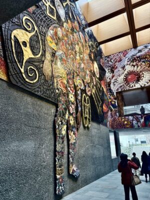
Photo credit: Anastasia Adeler
__________________________
Princeton Collects
Princeton Collects reads as a conversation assembled over time. The exhibition does not aim to summarize the museum’s holdings. Instead, it traces how a collection comes into being — through attention, commitment, and continuity.
The space is composed with restraint. Works appear at intervals that allow each of them to hold its own ground. Paintings, drawings, objects, fragments — each is given enough room to establish presence before entering into dialogue with the next. The gallery does not rush the eye.
People move through the gallery in varied ways. Some drift laterally, tracing visual connections. Others remain with a single piece, stepping back and forward, adjusting their distance. These movements feel unforced. The room accommodates them.
I noticed how often visitors approached a work before turning to its label. Looking happened first. Reading followed later, if at all. The design supports this order naturally. The objects set the tempo.
Scale becomes one of the guiding forces. A small drawing draws the body inward. A larger canvas pulls the gaze across the wall. Surface matters here. Pigment thickens. Lines hesitate or assert themselves. Materials respond differently to light, and the light gives each of them time.
Color plays a subtle role. The walls carry tones that hold the works steady rather than framing them theatrically. Frames sit comfortably within the architecture. Nothing calls attention to itself more than necessary.
What emerges is an understanding of collecting as an ongoing practice rather than a completed gesture. Objects acquired decades apart share space without hierarchy. The distances between them feel intentional, as if each work were placed with awareness of what it would encounter across the room.
Princeton Collects makes visible the idea that a university museum is shaped as much by patience as by vision. The exhibition does not attempt to impress. It allows relationships to surface gradually between objects, between generations of viewers, between moments of attention separated by years.
From here, the transition toward the ancient feels natural. The eye has learned how to stay. The body has learned how to wait. The next galleries deepen that experience by extending it across centuries.
Ancient Mediterranean Art
The transition into the Ancient Mediterranean Art galleries happens almost imperceptibly. The atmosphere thickens. Stone begins to register differently. Surfaces hold weight, not only visually, but physically — through texture, scale, and proximity.
Relief fragments, vessels, carved elements, architectural pieces occupy the space with a grounded confidence. Their placement allows the body to move close, then step back, then return again. The experience unfolds through distance rather than instruction.
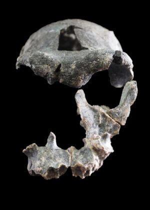
The false door from the tomb of the Egyptian priestess Ankh-Hathor holds a central position. Its surface carries layers of intention — ritual, passage, belief shaped through stone. Carved as a threshold, it suggests movement without requiring it. The object remains still, yet its meaning is spatial. You stand before it as one would stand before an entrance.
The carving reveals itself gradually. Lines deepen. Figures emerge through shadow and light. What first appears decorative settles into structure. The stone records hands, tools, repetition. Time becomes legible through labor.
______________________________
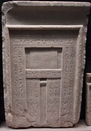
Example of an Egyptian false door displayed at the Louvre, France. CC BY-SA 3.0, Wikimedia Commons
______________________________
Nearby objects extend this material conversation. Ceramic forms carry the memory of use. Their proportions align with the human hand. Their surfaces retain subtle irregularities, traces of making rather than perfection. These are objects shaped through familiarity, through daily contact.
Light plays an essential role here. It settles across stone and clay without flattening them. Shadows collect in incisions and folds. A slight shift in position alters the reading of a surface. You begin to understand that these works ask for patience.
People respond instinctively. They slow. They lean in. They circle back.
The gallery avoids theatrical framing. Instead, it allows material to lead. Stone remains stone. Clay remains clay. Meaning accumulates through attention rather than explanation.
In this context, archaeology feels immediate. The distance between then and now compresses. Objects cease to function as evidence alone. They regain their status as things that once existed within lived space — touched, carried, placed, returned to.
Standing there, you become aware of how the museum supports this encounter. The proportions of the room hold the body comfortably. Sightlines remain clear. The architecture does not compete with the objects. It gives them room to speak through their own weight.
This section deepens what began earlier in the building. The museum’s understanding of attention extends across centuries. The ancient is not isolated. It is integrated into a continuous field of looking, making, and preserving.
From here, the presence of conservation feels inevitable — the work that allows these objects to remain present, available, and cared for.
Conservation Studios
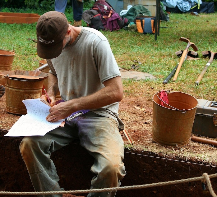
The Conservation Studios extend the logic of the galleries into a different register of time. Here, attention shifts from what has endured to how endurance is sustained.
Behind glass walls, work unfolds in plain sight. Objects rest on supports shaped precisely to their contours. Paintings lie flat under measured light. Tools are arranged with economy. Hands move with familiarity and care. Nothing here feels provisional. Everything suggests continuity.
Visitors stop without prompting. Some remain longer than expected. The studios hold their gaze not through activity alone, but through concentration. Watching conservation work becomes a lesson in scale — the scale of gesture, of time invested, of responsibility carried forward.
What stands out is the absence of separation between scholarship and care. Conservation is presented as part of the museum’s public life, embedded rather than concealed. The process belongs to the same architectural rhythm as the galleries themselves.
From certain angles, reflections overlap. The conservator’s hands align with an object’s surface. The glass catches fragments of surrounding space. These moments collapse distance between observer and work, reinforcing the idea that preservation is not abstract. It is physical, sustained, human.
The studios also recalibrate how one understands the objects just seen. Stone reliefs, ceramic vessels, painted surfaces now carry an additional layer of meaning. Their continued presence is no longer assumed. It is earned through labor, knowledge, and restraint.
Students pause here. Scholars linger. Visitors return after moving on. The space accommodates repeated encounters, acknowledging that understanding deepens through revisiting rather than completion.
In this part of the museum, time stretches forward. Conservation speaks to the future as much as to the past. Objects remain active participants in an ongoing exchange — studied, maintained, prepared for encounters yet to come.
_________________________________
Leaving the studios, you carry a heightened awareness of what it takes for a museum to function as a place of trust. The galleries depend on this work quietly, consistently, without display.
From here, the experience begins to fold back on itself. What you have seen gains weight. What you have noticed sharpens. The museum prepares you, gently, for departure.
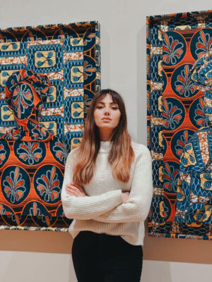
The author, Anastasia Adeler
By the time I left the museum, the light outside had changed. The campus looked familiar again, but something in my pace did not. I carried with me the image of that man I noticed earlier — sitting still, slightly leaning forward, his attention fixed, his hands quiet at his sides. I never learned what he was thinking. A place he once belonged to? A person he loved? A life he lived before this one? A friendship? A loss? Or a memory that had waited patiently for the right moment to return? I only know that the museum gave him space to think at all. This, perhaps, is the museum’s most lasting gesture. It does not rush the visitor toward conclusions. It allows encounters to unfold at a human tempo — between object and memory, between form and feeling. Ancient works do not sit behind time; contemporary ones do not compete for relevance. They coexist in a shared present, not asking for any interpretation.
As I walked away, I realized that the experience had followed me outward. The questions stayed open. The attention remained intact.
Unlike the majority of other places, The Princeton University Art Museum stays with you because of how you are taught to look.