Archives

Rainforest Kingdoms: Maya Archaeology under the Canopy

Join Dr. Anabel Ford of UC Santa Barbara’s Mesoamerican Research Center to journey through three countries of Mesoamerica, exploring one of the world’s greatest monumental ancient civilizations — the ancient Maya. See the iconic sites of Tikal, Calakmul, Palenque, among other well-known sites, including a unique exploration of El Pilar, a major Maya city where visitors can walk by monuments on paths enshrouded in the forest and where research programs are revealing how the ancient Maya practiced sustainable agricultural strategies.

In contrast with other tours of the Maya forest, this mega-trip will include visits to no less than 15 archaeological sites over 15 days, so it will be archaeologically immersive! This experience will also introduce you to the distinctive research that Dr. Ford* has conducted on the conservation of ancient Maya monuments, and a unique Maya practice of sustainable agriculture known as the Milpa Forest Garden. You will also meet local community members and see how the legacy of the ancient Maya past lives on today in its people.

See the itinerary below. Individuals who are interested in participating in this travel opportunity should email Dan McLerran at populararchaeology@gmail.com. More information will be provided when the program has been finalized. 

The Itinerary

Day 1: Arrive at the Philip Goldson International Airport near Belize City and transfer to settle into your hotel in the Corozal Region with a Welcome Dinner, where your Tour Director and the tour expert Dr. Anabel Ford will go over the goals and logistics of the fascinating trip ahead of you.

Day 2: 
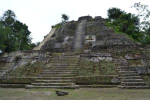
Next, travel by deluxe motor coach and boat to the monumental ancient city of Lamanai. Your local guide will walk you through the imposing structural remains, including the Mask Temple, the Jaguar Temple, and the High Temple. This city was occupied for over three millennia, beginning in the Early Preclassic Maya period and continuing through the Spanish and British Colonial periods, and even into the 20th century with Central American refugee resettlement. The Classic monuments of Lamanai were neglected like other Maya cities, yet archaeological research show that it was a vital occupation at the time of the brutal Spanish contact. Your breakfast, lunch and dinner will be included on this day.

Day 3: Your local guides will spend a combined time of one full day to explore the monumental remains of ancient Cerros,located on a distant coastal point, and Santa Rita within the town. Santa Rita, anciently known as Chetumal, had its beginning as much as 4,000 years ago, but flourished most notably in the Postclassic period, when many other cities of the Classic Maya declined. The ancient center of Cerros is dated to the Preclassic and endured to the Postclassic period, but saw its zenith in the Late Preclassic. Enjoy the view of the Bay and the Caribbean from here! Your breakfast, lunch and dinner will be included on this day.

Day 4: We will spend a full day of travel as we make our way by private motor coach to the Chetumal region of Mexico, crossing the border and then shortly to our hotel destination where we will relax in the evening. Breakfast and dinner are both included on this day.

Day 5: Today in Chetumal we will visit the Museum of Maya Culture, which features multi-media exhibits on the history, culture and accomplishments of the Mayas. After lunch, we will visit the famous Fort San Felipe Bacalar. The beautifully preserved small Spanish fort is over 270 years old and is surrounded by a moat. It is known for its spectacular canons and ramparts, and also features a museum with artifacts, murals and interactive exhibits. Enjoy a free evening afterwards in Chetumal. Breakfast is included on this day.

Day 6: 
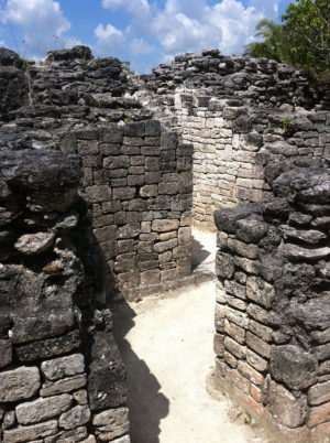
Today we depart early for the Mexican state of Campeche. On our way, we will stop at the archaeological sites of Dzibanche and Kohunlich. Dzibanche was a large city and is now thought to have been the early capital of the Kan dynasty, which later ruled from the city of Calakmul. The hieroglyphic stairway at Dzibanche features the earliest known use of the Kan dynasty emblem glyph, dated to AD 495. Kohunlich, a large site where most of the mounds still remain unexcavated, was settled by 200 BC. Kohunlich was a regional trade center and is best known for its Temple of the Masks, an Early Classic pyramid whose central stairway is flanked by huge humanized stucco masks. Breakfast, lunch and dinner are included on this day.

Day 7: 
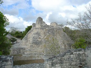
Today we will visit — count them — three ancient Maya centers: Becan, Xpuhil, Chicana, and the historic town of Zoh Laguna. Becan was occupied as early as about 550 BC, and became a major population center in the Late Preclassic. Notably, substantial earthworks and ramparts were constructed around the city. Becan was neglected by about 1200. Xpuhil, occupied between 300 and 1200 AD, was settled in the Early Classic period, although most of the structures and artifacts found at the site are dated to the end of the Classic period. Xpuhil is known for its “false” temples, structures that are not functional but serve as as living performance spaces and unclimbable stairways. Breakfast, lunch and dinner are included on this day.
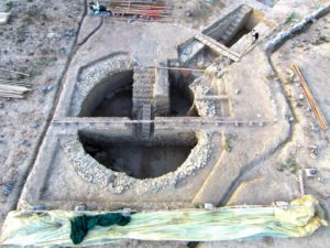
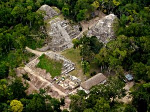
Day 8: 
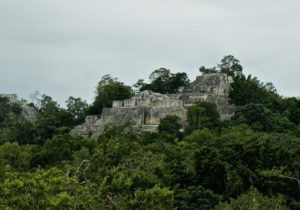
Our guide will afford us an entire day to explore the great ancient city of Calakmul which, along with Tikal, was one of the ancient Maya’s most significant power centers. Calakmul and Tikal were known to be great ancient rivals, fighting each other for regional control. Calakmul was the seat of the ‘Kingdom of the Snake.’ The Snake Kingdom reigned during most of the Classic period and the city is thought to have had a population of 50,000, wielding influence at some times over other centers as distant as 150 kilometers. Consisting of 6,750 identified structures, the largest is the massive Structure 2 pyramid, which is over 148 ft high, among the tallest and largest of the Maya pyramids. Breakfast, lunch and dinner are included on this day.
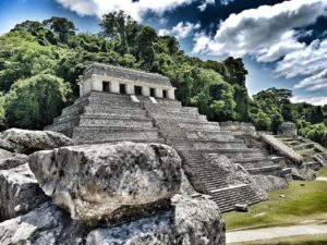
Day 9: 
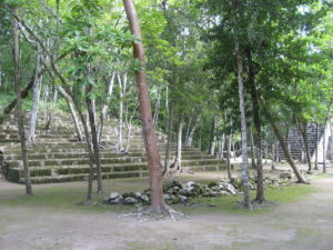
Today we make our way to Palenque, the ancient city dubbed by some scholars as the ‘Athens’ of the ancient Maya. On our way, we will stop to visit the Balamku archaeological site not far from the entrance to Calakmul. Although Balamku is a small site, it features elaborate plaster facades dating to the Early Classic period discovered when looters were apprehended. It is known for having one of the largest surviving stucco friezes in the Maya world. First occupied in about 300 BC, its most important buildings date from AD 300–600. Breakfast, lunch and dinner are included on this day.

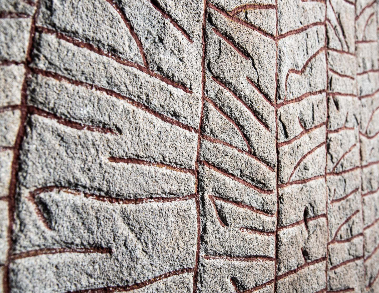
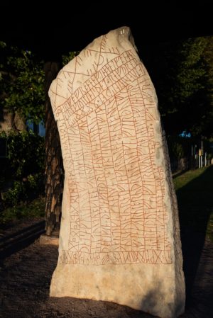
Day 10: We spend the entire day at Palenque, which boasts some of the most beautiful architecture, sculpture, and roof combs and bas-relief carvings of the Maya world. Scholars have reconstructed the history of Palenque through decipherment of the hieroglyphic inscriptions on its monuments, such that historians now have a long sequence of the ruling dynasty of Palenque in the 5th century, including extensive knowledge of the city’s rivalry with other states such as Calakmul and Toniná. Palenque is known for its ruler K’inich Janaab Pakal, or Pacal the Great, whose famous spectacular tomb was found and excavated in the Temple of the Inscriptions. The Museum of Palenque, which we will visit, provides a remarkable experience for understanding this tomb.

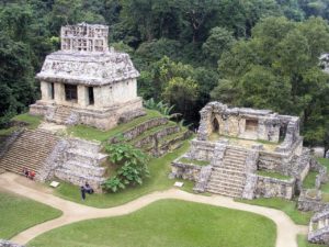
As with all of the sites we are visiting, it is estimated that less than 10% of the city’s total area has been exposed, with more than a thousand structures still enshrouded by the surrounding jungle.

Breakfast, lunch and dinner are included on this day.

Day 11: We will spend a full day of travel as we make our way by private motor coach to the Tikal region in Guatemala, crossing the border from Mexico and eventually to our hotel destination where we will relax in the evening. This trip will traverse south of the Lacandon forest and cross the Usumacinta River near Tenosique, across the savannas into the Lake Peten Itza area.  Breakfast, lunch and dinner are all included on this day.

Day 12: We will spend a full day exploring the magnificent city of ancient Tikal, including the causeways, great plaza, central acropolis, ball courts and the towering temples that afford views of the vast Maya forest. We will also make time for the museums. Tikal was the capital of one of the most powerful kingdoms of the ancient Maya. Monumental architecture dates back to the 4th century BC, but the city reached its zenith during the Classic Period, from c. 200 to 900 AD. It was during this time that Tikal dominated much of the Maya region politically, economically, and militarily, while also interacting with the greater Mesoamerican sphere, including Teotihuacan in the Valley of Mexico.

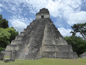
Tikal declined at the end of the Late Classic Period, and was neglected from the 10th century AD. Breakfast, lunch and dinner are included on this day.

Day 13: Today the group will transfer back into Belize for a stay in the Cayo District, stopping en route to tour the monuments at Yaxha and Topoxte Island. Yaxha was founded in the Middle Preclassic period (c. 1000–350 BC), and grew to become a large city in the eastern Petén lakes region during the Late Preclassic (c. 350 BC – AD 250), expanding further during the Early Classic (c. AD 250–600).

Evidence suggests that Yaxha was also influenced by Teotihuacan during the Early Classic with a stela representing the goggle eyes of Tlaloc. The city thrived into the Terminal Classic (c. 800–900). By the Postclassic period (c. 900–1525), focused attention was at Topoxte, located on islands on Yaxha Lake. Tppoxte was the capital of the Kowoj Maya, linked in rivalry to Noh Petén, on the island of Flores. Breakfast, lunch and dinner are all included on this day.
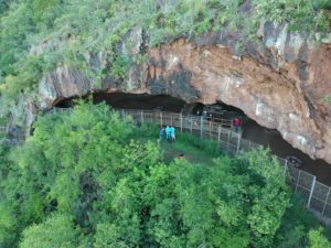
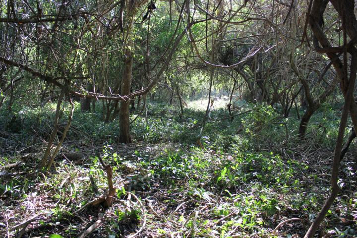
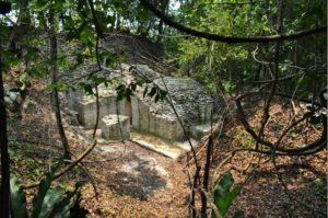
Day 14: 
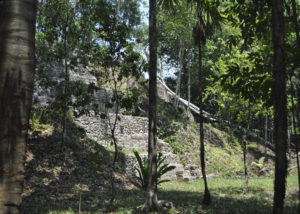
Today the group will visit the El Pilar archaeological site. Here you will be able to compare your experiences of the great Maya world to a new alternative: Archaeology Under the Canopy. With a construction chronology that dates from at least 800 BCE to 1000 CE, the site is among the largest in the local area. At El Pilar, trails wander beneath the jungle cover, beckoning you past temples, inviting you to linger across open plazas, and tempting you around houses. On the archaeological trails at El Pilar, efforts were made to feature the exquisite flora and encourage you to enjoy the fauna.

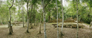
Image courtesy Macduff Everton

Day 15: The integral Maya forest garden: It is a common belief that the milpa fields destroyed the forests. New studies, however, show that the forest today was shaped by sustainable practices developed by the ancient Maya millennia ago. The ancient Maya both maintained the environment and utilized it for food, shelter, and medicine. The practice of milpa, a sophisticated and sustainable sequence that alternates between cultivated fields and forest gardens, builds a landscape of useful plants that contribute to the biodiversity of the forest. Contemporary Maya forest gardeners maintain the forest as a garden through the practices of their ancestors. We will have a chance to visit a working forest garden, the ChakHaKol of master forest gardener Narciso Torres.  He will also share his vision for the school garden. You will learn how the Forest Garden contributes to action on climate change by:

1. Reducing temperature

2. Increasing biodiversity

3. Conserving water

4. Building fertility; and

5. Reducing erosion

…….and caring for people

Day 16: We visit the Belize Zoo and Tropical Education Center with a local guide. The Belize Zoo is home to more than 175 animals of about 48 species, all native to Belize. The zoo differs from most other typical zoos in that the natural environment of Belize is left entirely intact within the zoo. The dense, natural vegetation is separated only by gravel trails through the forest. The zoo’s goal is to educate visitors about the wildlife of Belize through encountering the animals in their natural habitat. Breakfast and dinner are included on this day.

Day 17: We transfer to the airport in Belize City to depart for home. Breakfast is included.

___________________________

It is estimated at this point that the tour cost will range between $4,500 and $5,000 per person, double occupancy, land trip. A single room will add between $850 and $900. Airfare could add about $1,000, more or less, depending upon the person’s departure point.

If 14 or more individuals participate in this travel opportunity, Popular Archaeology Magazine will be donating funds toward the research and programs related to El Pilar and the Maya Forest Garden. Thus, your participation will constitute an important contribution to the development and sustenance of these programs.

Individuals who are interested in participating in this travel opportunity should email Dan McLerran at populararchaeology@gmail.com.  More information will be provided when the program has been finalized.

*About Dr. Ford

Dr. Anabel Ford has decoded the ancient Maya landscape by combining archaeological research with traditional Maya knowledge. Ford distinguished herself in Mesoamerican archaeology with the study of patterns of settlement and environment, demystifying traditional views of the ancient Maya by examining the common human aspects of this civilization that shed light on sustainable farming practices. This forms the foundation for her current inquiries.

Ford is recognized for her rediscovery of the ancient Maya city center of El Pilar, on the contemporary divide of Belize and Guatemala, which she has transformed into a living museum and laboratory. El Pilar has become a familiar and innovative archaeological site practicing “Archaeology Under the Canopy” — using the landscape as a tool of conservation. Monuments covered with sweet moss and draped with Ramon trees make a striking and unique Maya experience. El Pilar is a model of synergy between nature and culture and is where Ford’s focus on cultural ecology — the multifaceted relationships of humans and their environment—is being applied to benefit contemporary populations. The co-evolution of human societies and the environment bring particular relevance to the study of Maya prehistory.

At El Pilar, Ford is advancing programs that simulate “Maya Forest Gardens” as an alternative to conventional monocrop farming. Using anthropology as a springboard for interdisciplinary research, she proposes that ancient traditions are yielding contemporary solutions for the Maya forest of Belize, Guatemala, and Mexico.

____________________________

El Pilar: Preserving the Maya Legacy from UC Santa Barbara on Vimeo.

____________________________

____________________________

Advertisement

The Vikings erected a runestone out of fear of a climate catastrophe

UNIVERSITY OF GOTHENBURG—Several passages on the Rök stone – the world’s most famous Viking Age runic monument – suggest that the inscription is about battles and for over a hundred years, researchers have been trying to connect the inscription with heroic deeds in war. Now, thanks to an interdisciplinary research project, a new interpretation of the inscription is being presented. The study* shows that the inscription deals with an entirely different kind of battle: the conflict between light and darkness, warmth and cold, life and death.

The Rök runestone, erected in Östergötland around 800 CE, is the world’s most famous runestone from the Viking Age, but has also proven to be one of the most difficult to interpret. This new interpretation is based on a collaboration between researchers from several disciplines and universities.

“The key to unlocking the inscription was the interdisciplinary approach. Without these collaborations between textual analysis, archaeology, history of religions and runology, it would have been impossible to solve the riddles of the Rök runestone,” says Per Holmberg, professor in Swedish at the University of Gothenburg, who led the study.

A previous climate catastrophe

The study is based on new archaeological research describing how badly Scandinavia suffered from a previous climate catastrophe with lower average temperatures, crop failures, hunger and mass extinctions. Bo Gräslund, professor in Archaeology at Uppsala University, points to several reasons why people may have feared a new catastrophe of this kind:

“Before the Rök runestone was erected, a number of events occurred which must have seemed extremely ominous: a powerful solar storm coloured the sky in dramatic shades of red, crop yields suffered from an extremely cold summer, and later a solar eclipse occurred just after sunrise. Even one of these events would have been enough to raise fears of another Fimbulwinter,” says Bo Gräslund.

Nine riddles

According to the researchers’ new interpretation now being published, the inscription consists of nine riddles. The answer to five of these riddles is “the Sun”. One is a riddle asking who was dead but now lives again. The remaining four riddles are about Odin and his warriors.

Olof Sundqvist, professor in History of Religions at Stockholm University, explains the connection:

“The powerful elite of the Viking Age saw themselves as guarantors for good harvests. They were the leaders of the cult that held together the fragile balance between light and darkness. And finally at Ragnarök, they would fight alongside Odin in the final battle for the light.”

Parallels with other Old Norse texts

According to the researchers, several points in the inscription have clear parallels with other Old Norse texts that no one has previously noted.

“For me, it’s been almost like discovering a new literary source from the Viking Age. Sweden’s answer to the Icelandic Poetic Edda!” says Henrik Williams, professor in Scandinavian Languages with a specialty in Runology at Uppsala University.

_______________________________

Rök runes. Helge Andersson

_______________________________

Rök runestone. Helge Andersson

_______________________________

Article Source: UNIVERSITY OF GOTHENBURG news release

*The Rök runestone and the end of the world (Futhark: International Journal of Runic Studies): https://doi.org/10.33063/diva-401040

_______________________________

Advertisement

Study puts the ‘Carib’ in ‘Caribbean,’ boosting credibility of Columbus’ cannibal claims

FLORIDA MUSEUM OF NATURAL HISTORY—GAINESVILLE, Fla.—Christopher Columbus’ accounts of the Caribbean include harrowing descriptions of fierce raiders who abducted women and cannibalized men – stories long dismissed as myths.

But a new study suggests Columbus may have been telling the truth.

Using the equivalent of facial recognition technology, researchers analyzed the skulls of early Caribbean inhabitants, uncovering relationships between people groups and upending longstanding hypotheses about how the islands were first colonized.

One surprising finding was that the Caribs, marauders from South America and rumored cannibals, invaded Jamaica, Hispaniola and the Bahamas, overturning half a century of assumptions that they never made it farther north than Guadeloupe.

“I’ve spent years trying to prove Columbus wrong when he was right: There were Caribs in the northern Caribbean when he arrived,” said William Keegan, Florida Museum of Natural History curator of Caribbean archaeology. “We’re going to have to reinterpret everything we thought we knew.”

Columbus had recounted how peaceful Arawaks in modern-day Bahamas were terrorized by pillagers he mistakenly described as “Caniba,” the Asiatic subjects of the Grand Khan. His Spanish successors corrected the name to “Caribe” a few decades later, but the similar-sounding names led most archaeologists to chalk up the references to a mix-up: How could Caribs have been in the Bahamas when their closest outpost was nearly 1,000 miles to the south?

But skulls reveal the Carib presence in the Caribbean was far more prominent than previously thought, giving credence to Columbus’ claims.

Face to face with the Caribbean’s earliest inhabitants

Previous studies relied on artifacts such as tools and pottery to trace the geographical origin and movement of people through the Caribbean over time. Adding a biological component brings the region’s history into sharper focus, said Ann Ross, a professor of biological sciences at North Carolina State University and the study’s lead author.

Ross used 3D facial “landmarks,” such as the size of an eye socket or length of a nose, to analyze more than 100 skulls dating from about A.D. 800 to 1542. These landmarks can act as a genetic proxy for determining how closely people are related to one another.

The analysis not only revealed three distinct Caribbean people groups, but also their migration routes, which was “really stunning,” Ross said.

Looking at ancient faces shows the Caribbean’s earliest settlers came from the Yucatan, moving into Cuba and the Northern Antilles, which supports a previous hypothesis based on similarities in stone tools. Arawak speakers from coastal Colombia and Venezuela migrated to Puerto Rico between 800 and 200 B.C., a journey also documented in pottery.

The earliest inhabitants of the Bahamas and Hispaniola, however, were not from Cuba as commonly thought, but the Northwest Amazon – the Caribs. Around A.D. 800, they pushed north into Hispaniola and Jamaica and then the Bahamas where they were well established by the time Columbus arrived.

“I had been stumped for years because I didn’t have this Bahamian component,” Ross said. “Those remains were so key. This will change the perspective on the people and peopling of the Caribbean.”

For Keegan, the discovery lays to rest a puzzle that pestered him for years: why a type of pottery known as Meillacoid appears in Hispaniola by A.D. 800, Jamaica around 900 and the Bahamas around 1000.

“Why was this pottery so different from everything else we see? That had bothered me,” he said. “It makes sense that Meillacoid pottery is associated with the Carib expansion.”

The sudden appearance of Meillacoid pottery also corresponds with a general reshuffling of people in the Caribbean after a 1,000-year period of tranquility, further evidence that “Carib invaders were on the move,” Keegan said.

Raiders of the lost Arawaks

So, was there any substance to the tales of cannibalism?

Possibly, Keegan said.

Arawaks and Caribs were enemies, but they often lived side by side with occasional intermarriage before blood feuds erupted, he said.

“It’s almost a ‘Hatfields and McCoys’ kind of situation,” Keegan said. “Maybe there was some cannibalism involved. If you need to frighten your enemies, that’s a really good way to do it.”

Whether or not it was accurate, the European perception that Caribs were cannibals had a tremendous impact on the region’s history, he said. The Spanish monarchy initially insisted that indigenous people be paid for work and treated with respect, but reversed its position after receiving reports that they refused to convert to Christianity and ate human flesh.

“The crown said, ‘Well, if they’re going to behave that way, they can be enslaved,'” Keegan said. “All of a sudden, every native person in the entire Caribbean became a Carib as far as the colonists were concerned.”

___________________________

Researchers analyzed the skulls of early Caribbean inhabitants, using 3D facial “landmarks” as a genetic proxy for determining how closely people groups were related to one another. Ann Ross/North Carolina State University

___________________________

Article Source: FLORIDA MUSEUM OF NATURAL HISTORY news release.

Author: Natalie van Hoose

___________________________

Advertisement

Early humans arrived in Southeast Asia later than previously believed

AMERICAN ASSOCIATION FOR THE ADVANCEMENT OF SCIENCE—New dates from the World Heritage archeological site at Sangiran on the island of Java suggest that that the first appearance of Homo erectus occurred more recently than previously thought, researchers report. The new findings place the arrival of the first hominins in Sangiran between 1.3-1.5 million years ago (Ma), suggesting that early humans migrated from Asia to Southeast Asia and Java nearly 300,000 years later than previously believed. The fossil-rich Sangiran dome in Java contains the oldest human fossils in Southeast Asia and is widely regarded as one of the most important sites in understanding the evolution of our early ancestors and their slow march across the globe. To date, more than 100 specimens from at least three different hominid species have been recovered from Sangrian sediments. However, despite decades of research, the site’s chronology remains uncertain and controversial, particularly the timing of H. erectus‘ first appearance in the region, and the current widely accepted dates are difficult to reconcile with other early sites in Asia. An accurate understanding of the Sangiran chronology is crucial for understanding the earliest human migrations and settlements in Asia. To resolve this debate, Shuji Matsu’ura and colleagues used a combination of fission-track and Uranium/Lead (U/Pb) dating to determine the age of volcanic zircons found above, below and within the hominin-bearing layers of the Sangiran fossil deposit. While previous estimates have estimated hominin arrival as early as 1.7 Ma, Matsu’ura et al.’s findings suggest a much younger date; likely by 1.3 Ma, however no earlier than 1.5 Ma. In a related Perspective, Boris Brasseur discusses the study’s findings in more detail.

_________________________

Homo erectus (cranial illustration). Wikimedia Commons, Public Domain

_________________________

*”A younger ‘earliest human migration’ from Asia to Southeast Asia,” by B. Brasseur at UMR7058 EDYSAN in Amiens, France; B. Brasseur at Université de Picardie Jules Verne Pôle Santé in Amiens, France.

Article Source: AAAS news release

_________________________

Advertisement

Early humans revealed to have engineered optimized stone tools at Olduvai Gorge

UNIVERSITY OF KENT—Early Stone Age populations living between 1.8 – 1.2 million years ago engineered their stone tools in complex ways to make optimized cutting tools, according to a new study by University of Kent and UCL.

The research, published in the Journal of Royal Society Interface, shows that Palaeolithic hominins selected different raw materials for different stone tools based on how sharp, durable and efficient those materials were. They made these decisions in conjunction with information about the length of time the tools would be used for and the force with which they could be applied. This reveals previously unseen complexity in the design and production of stone tools during this period.

The research was led by Dr Alastair Key, from Kent’s School of Anthropology and Conservation, and is based on evidence from mechanical testing of the raw materials and artifacts found at Olduvai Gorge in Tanzania—one of the world’s most important sites for human origins research.

Dr Key collaborated with Dr Tomos Proffitt, from UCL Institute of Archaeology, and Professor Ignacio de la Torre of the CSIC-Centro de Ciencias Humanas y Sociales in Madrid, for the study.

Their research, which employed experimental methods more commonly used in modern engineering research, shows that hominins preferentially selected quartzite, the sharpest but least durable stone type at Olduvai for flake tools; a technology thought to have been used for expedient, short-lived cutting activities.

Chert, which was identified as being highly durable and nearly as sharp as quartzite, was only available to hominins for a short 200,000 year period. Whenever it was available, chert was favored for a variety of stone tool types due to its ability to maximize cutting performance over extended tool-use durations. Other stone types, including highly durable lavas, were available at Olduvai, however their use varied according to factors such as how long a tool was intended to be used for, a tools potential to create high cutting forces, and the distance hominins had to travel to raw material sources.

The study reveals a level of complexity and flexibility in stone tool production previously unseen at this time. Earlier research had demonstrated Early Stone Age populations in Kenya to select highly durable stone types for tools, but this is the first time cutting edge sharpness has been able to be considered. By selecting the material best suited to specific functional needs, hominins optimized the performance of their tools and ensured a tools efficiency and ‘ease-of-use’ was maximized.

Dr Key said: ‘Why Olduvai populations preferentially chose one raw material over another has puzzled archaeologists for more than 60 years. This has been made all the more intriguing given that some stone types, including lavas and quartzite, were always available.

‘What we’ve been able to demonstrate is that our ancestors were making quite complex decisions about which raw materials to use, and were doing so in a way that produced tools optimized for specific circumstances. Although we knew that later hominin species, including our own, were capable of such decisions, it’s amazing to think that populations 1.8 – 1.2 million years ago were also doing so.’

Dr Proffitt added: ‘Early hominins during the Oldowan were probably using stone flakes for a variety of tasks. Mostly for butchering animals whilst scavenging, but also probably for cutting various plants and possibly even shaping wood. A durable cutting edge would have been an important factor when using these tools.

‘There are many modern analytical techniques used in material sciences and engineering that can be used to interrogate the archaeological record, and may provide new insights into the mechanical properties of such tools and artifacts. By understanding the way that these tools work and their functional limits it allows archaeologists to build up a greater understanding of the capabilities of our earliest ancestors at the dawn of technology.’

The team now hopes that researchers at other archaeological sites will want to apply similar mechanical tests and techniques to help understand the behavior of Stone Age populations.

____________________________

Olduvai Gorge in Tanzania, East Africa. Wikimedia Commons, Public Domain

____________________________

Article Source: UNIVERSITY OF KENT news release.

*’Raw material optimization and stone tool engineering in the Early Stone Age of Olduvai Gorge (Tanzania)’ is published in the Journal of the Royal Society Interface.

____________________________

Advertisement

Early modern humans cooked starchy food in South Africa 170,000 years ago

UNIVERSITY OF THE WITWATERSRAND—”The inhabitants of the Border Cave in the Lebombo Mountains on the Kwazulu-Natal/eSwatini border were cooking starchy plants 170 thousand years ago,” says Professor Lyn Wadley, a scientist from the Wits Evolutionary Studies Institute at the University of the Witwatersrand, South Africa (Wits ESI). “This discovery is much older than earlier reports for cooking similar plants and it provides a fascinating insight into the behavioral practices of early modern humans in southern Africa. It also implies that they shared food and used wooden sticks to extract plants from the ground.”

“It is extraordinary that such fragile plant remains have survived for so long,” says Dr Christine Sievers, a scientist from the University of the Witwatersrand, who completed the archaeobotanical work with Wadley. The underground food plants were uncovered during excavations at Border Cave in the Lebombo Mountains (on the border of KwaZulu-Natal Province, South Africa, and eSwatini [formerly Swaziland]), where the team has been digging since 2015. During the excavation, Wadley and Sievers recognised the small, charred cylinders as rhizomes. All appear to belong to the same species, and 55 charred, whole rhizomes were identified as Hypoxis, commonly called the Yellow Star flower. “The most likely of the species growing in KwaZulu-Natal today is the slender-leafed Hypoxis angustifolia that is favored as food,” adds Sievers. “It has small rhizomes with white flesh that is more palatable than the bitter, orange flesh of rhizomes from the better known medicinal Hypoxis species (incorrectly called African Potato).”

The Border Cave plant identifications were made on the size and shape of the rhizomes and on the vascular structure examined under a scanning electron microscope. Modern Hypoxis rhizomes and their ancient counterparts have similar cellular structures and the same inclusions of microscopic crystal bundles, called raphides. The features are still recognizable even in the charred specimens. Over a four-year period, Wadley and Sievers made a collection of modern rhizomes and geophytes from the Lebombo area. “We compared the botanical features of the modern geophytes and the ancient charred specimens, in order to identify them,” explains Sievers.

Hypoxis rhizomes are nutritious and carbohydrate-rich with an energy value of approximately 500 KJ/100g. While they are edible raw, the rhizomes are fibrous and have high fracture toughness until they are cooked. The rhizomes are rich in starch and would have been an ideal staple plant food. “Cooking the fibre-rich rhizomes would have made them easier to peel and to digest so more of them could be consumed and the nutritional benefits would be greater,” says Wadley.

Wooden digging sticks used to extract the plants from the ground

“The discovery also implies the use of wooden digging sticks to extract the rhizomes from the ground. One of these tools was found at Border Cave and is directly dated at circa 40,000 years ago,” says co-author of the paper and co-director of the excavation, Professor Francesco d’Errico, (Centre National de la Recherche Scientifique (CNRS), Université de Bordeaux, France and University of Bergen, Norway). Dr Lucinda Backwell (Instituto Superior de Estudios Sociales, ISES-CONICET, Tucumán, Argentina) also co-authored the paper and was a co-director of the excavation.

The plants were cooked and shared

The Hypoxis rhizomes were mostly recovered from fireplaces and ash dumps rather than from surrounding sediment. “The Border Cave inhabitants would have dug Hypoxis rhizomes from the hillside near the cave, and carried them back to the cave to cook them in the ashes of fireplaces,” says Wadley. “The fact that they were brought back to the cave rather than cooked in the field suggests that food was shared at the home base. This suggests that the rhizomes were roasted in ashes and that, in the process, some were lost. While the evidence for cooking is circumstantial, it is nonetheless compelling.”

Discoveries at Border Cave

This new discovery adds to the long list of important finds at Border Cave. The site has been repeatedly excavated since Raymond Dart first worked there in 1934. Amongst earlier discoveries were the burial of a baby with a Conus seashell at 74,000 years ago, a variety of bone tools, an ancient counting device, ostrich eggshell beads, resin, and poison that may once have been used on hunting weapons.

The Border Cave Heritage Site

Border Cave is a heritage site with a small site museum. The cave and museum are open to the public, though bookings are essential [Olga Vilane (+27) (0) 72 180 4332]. Wadley and her colleagues hope that the Border Cave discovery will emphasize the importance of the site as an irreplaceable cultural resource for South Africa and the rest of the world.

About Hypoxis angustifolia

Hypoxis angustifolia is evergreen, so it has visibility year-round, unlike the more common deciduous Hypoxis species. It thrives in a variety of modern habitats and is thus likely to have had wide distribution in the past as it does today. It occurs in sub-Saharan Africa, south Sudan, some Indian Ocean islands, and as far afield as Yemen. Its presence in Yemen may imply even wider distribution of this Hypoxis plant during previous humid conditions. Hypoxis angustifolia rhizomes grow in clumps so many can be harvested at once. “All of the rhizome’s attributes imply that it could have provided a reliable, familiar food source for early humans trekking within Africa, or even out of Africa,” said Lyn Wadley. Hunter-gatherers tend to be highly mobile so the wide distribution of a potential staple plant food would have ensured food security.

________________________

Border Cave excavation. Dr. Lucinda Backwell

________________________

Border Cave entrance in the Lebombo Mountains, South Africa. Ashley Kruger

________________________

Hypoxis angustifolia growth habit. Prof. Lyn Wadley/Wits University

________________________

Article Source: UNIVERSITY OF THE WITWATERSRAND news release

________________________

Advertisement

Rainforest Kingdoms: The Ancient Maya Under The Canopy

THIS IS NOT AN ORDINARY TOUR. Popular Archaeology is joining forces with Education First International and Dr. Anabel Ford of the MesoAmerican Research Center to host a one-of-kind group visit to iconic ancient Maya sites in Guatemala, Mexico and Belize. We say ‘one-of-a-kind’ because, unlike all other typical tours of ancient Maya sites in Central America, this one is archaeologically intense, visiting 15 ancient May centers in as many days and also focusing on subjects and issues not often touched upon through other more standard tours. Did the ancient Maya civilization really ‘collapse’ at all, as so many scholars have suggested? What is the evidence to suggest otherwise? What new lessons can we learn from the ancient Maya about sustainable living in an age of global climate change? How should the ancient monumental remains of the Maya be properly conserved and studied? Does the new remote sensing technology provide us with the best or ultimate means to uncovering the evidence of what the ancient Maya built and how they lived? These and many other questions and topics will be addressed on the scene by our expert host, Dr. Ford, who will accompany us to a variety of sites, including Tikal, Palenque, Calakmul, Yaxha, Lamanai, El Pilar, and many others, through three countries in Central America. Because of her decades of in-depth and unique research in the world of the ancient Maya, she will provide a perspective unlike what you can find with most other scholars in the field. Read more about her by going to http://www.marc.ucsb.edu/about/director, and by reading her profile at Wikipedia (https://en.wikipedia.org/wiki/Anabel_Ford). Whether you have visited many of these ancient sites or not, this travel opportunity promises to provide an experience unlike anything else in this region of the world. The travel group spaces will be limited in number so if you are seriously interested please let us know by sending an email to popularchaeology@gmail.com. The itinerary is now close to completion and the draft program, cost and tentative dates will be sent to you after we hear from you! 

___________________________

Advertisement

The Best Stories of 2019: Editor’s Pick

A look back on 2019: As we leave 2019 and look forward to another year of great articles in 2020, here is an encore of Popular Archaeology’s best stories of 2019!

Unearthing the Secrets of Smith Creek

Excavations are beginning to reveal the evolution of a pre-Columbian mound-builder site in Mississippi.

The First Siberians

Denisova Cave has yielded remarkable new implications and new questions about early humans in Asia.

Hidden Majesty: The Lost Grave of Richard III

Writing for young readers, author Laura Scandiffio relates the detailed story about the remarkable burial discovery of King Richard III and what it says about the real king, beyond the popular accounts and tales of infamy.

Technology One

Scientists are on the trail of discovering the earliest stone tools made by human ancestors in Africa.

1619: Archaeology and the Seeds of a Nation

Archaeological excavations at Jamestown in Virginia are yielding new material finds related to the Western Hemisphere’s first representative government, and the beginnings of slavery in the British colonies.

The North Side Story

In the high plateaus of eastern Algeria, some of the earliest evidence for human stone tool-making is emerging.

Early Americans, Part 1: Artifacts

Part 1 of an anthology of articles focusing on the findings that are informing a new paradigm about the early settling of the Americas.

Early Americans, Part 2: Bones

Fossil evidence bearing on the earliest peopling of the Americas.

Image above: Researchers in the East Chamber, Denisova cave, with (left to right) Michael Shunkov, Katerina Douka, Tom Higham, Maxim Kozlinkin.  (photo credit/copyright Sergey Zelinski, Russian Academy of Sciences).

Large scale feasts at ancient capital of Ulster drew crowds from across Iron Age Ireland

CARDIFF UNIVERSITY—People transported animals over huge distances for mass gatherings at one of Ireland’s most iconic archaeological sites, research* concludes.

Dr Richard Madgwick of Cardiff University led the study, which analyzed the bones of 35 animals excavated from Navan Fort, the legendary capital of Ulster. Researchers from Queen’s University Belfast, Memorial University Newfoundland and the British Geological Survey were also involved in the research.

The site had long been considered a center for ritual gatherings, as excavations found a huge 40m diameter building and a barbary ape cranium, likely from at least as far as Iberia. Results suggest the pigs, cattle and sheep were brought from across Ireland, perhaps being reared as far afield as Galway, Donegal, Down, Tyrone and Antrim. Evidence suggests some were brought over more than 100 miles.

Dr Madgwick, based in Cardiff University’s School of History, Archaeology and Religion, said: “Our results provide clear evidence that communities in Iron Age Ireland were very mobile and that livestock were also moved over greater distances than was previously thought.

“The high proportion of pig remains found there is very rare for this period. This suggests that Navan Fort was a feasting centre, as pigs are well-suited as feasting animals and in early Irish literature pork is the preferred food of the feast.

“It is clear that Navan Fort had a vast catchment and that the influence of the site was far-reaching.”

Researchers used multi-isotope analysis on samples of tooth enamel to unlock the origins of each animal. Food and water have chemical compositions linked to the geographical areas where they are sourced. When animals eat and drink, these chemical signals are archived in their teeth, allowing scientists to investigate the location where they were raised.

Co-author of the research, Dr Finbar McCormick, of Queen’s University, Belfast, said: “In the absence of human remains, multi-isotope analysis of animals found at Navan Fort provides us with the best indication of human movement at that time.

“Feasting, almost invariably associated with sacrifice, was a social necessity of early societies where the slaughter of a large domesticate necessitated the consumption of a large amount of meat in a short period of time.”

Earlier this year, Dr Madgwick’s research of 131 pigs found at sites near Stonehenge revealed animals came from as far away as Scotland and numerous other locations across the British Isles. Before this, the origins of people who visited this area and the extent of the population’s movements at the time had been long-standing enigmas in British prehistory.

Dr Madgwick added: “Transporting animals across the country would have involved a great deal of time and effort so our findings demonstrate the important role they played in society. Food was clearly a central part of people’s exchanges and traditions.”

________________________________

One of the analyzed pig jaws for the study. Dr Richard Madgwick

________________________________

Article Source: Cardiff University news release

*http://www.nature.com/articles/s41598-019-55671-0

________________________________

Advertisement

Ancient Mediterranean seawall first known defense against sea level rise and it failed

FLINDERS UNIVERSITY—Ancient Neolithic villagers on the Carmel Coast in Israel built a seawall to protect their settlement against rising sea levels in the Mediterranean, revealing humanity’s struggle against rising oceans and flooding stretches back thousands of years.

An international team of researchers from the University of Haifa, Flinders University in Australia, the Israel Antiquities Authority and The Hebrew University uncovered and analyzed the oldest known coastal defence system anywhere in the world, constructed by ancient settlers from boulders sourced in riverbeds from 1-2km near their village.

In a study published today in PLOS ONE, Dr Ehud Galili from the Zinman Institute of Archaeology, University of Haifa, explains that the over 100 meter long seawall proved to be a temporary reprieve and the ancient village was eventually abandoned and inundated.

This discovery provides new insights into ancient human responses to current threats posed by sea level rise.

“During the Neolithic, Mediterranean populations would have experienced a sea-level rise of 4 to 7 mm a year or approximately 12-21cm during a lifetime (up to 70 cm in a 100 years). This rate of sea-level rise means the frequency of destructive storms damaging the village would have risen significantly,” says Dr Galili.

“The environmental changes would have been noticeable to people, during the lifetime of a settlement across several centuries. Eventually the accumulating yearly sea-level necessitated a human response involving the construction of a coastal protection wall similar to what we’re seeing around the world now.”

In a scenario comparable to the sinking capital of Jakarta today, ancient Tel Hreiz was built at a safe elevation of up to 3 meters above sea level but post glacial sea-level rises of up to 7mm a year posed a threat to settlers and their homes.

Coauthor Dr Jonathan Benjamin from Flinders University in Australia says the Tel Hreiz settlement was first recognized as a potential archaeological site in the 1960’s but the relevant areas that were exposed by natural processes in 2012, revealed this previously unknown archaeological material

“There are no known or similar built structures at any of the other submerged villages in the region, making the Tel Hreiz site a unique example of this visible evidence for human response to sea-level rise in the Neolithic.”

“Modern sea-level rise has already caused lowland coastal erosion around the world. Given the size of coastal populations and settlements, the magnitude of predicted future population displacement differs considerably to the impacts on people during the Neolithic period.”

Current estimates predict 21st century sea level rise to range from 1.7 to 3mm per year, representing a smaller change when compared to the threat experienced by the Neolithic community that built the ancient sea wall, however many of the same challenges will be posed according to the authors.

“Many of the fundamental human questions and the decision-making relating to human resilience, coastal defense, technological innovation and decisions to ultimately abandon long-standing settlements remain relevant.” says Dr Galili.

___________________________

Eastern Mediterranean and the Israeli coast: Submerged Neolithic settlements off the Carmel coast 2019. John McCarthy after Galili et al.

___________________________

Photographs of finds from the Tel Hreiz settlement:
(a-b) exposure of stone-built features in shallow water.
(c) wooden posts dug into the seabed.
(d) bifacial flintadze.
(e) in situ stone bowl made of sandstone.
(f) in situ basalt grounding stone (scale = 20cm);
(g) burial 1.
(h) suspected stone-built cist grave – view from the east
(scale = 20cm).
(i) in situ antler of Mesopotamian fallow deer, Dama dama mesopotamica. All photographs by E. Galili with the exception of Fig 3G by V. Eshed

___________________________

Isometric modeling of the Tel Hreiz seawall based on an aerial photograph of the site and its hinterland: (b) schematic cross section of the site today; (c) during the Pottery Neolithic period. J. McCarthy, E. Galili, and J. Benjamin.

___________________________

Article Source: Flinders University news release

___________________________

Advertisement

Researchers determine age for last known settlement by a direct ancestor to modern humans

UNIVERSITY OF IOWA—Homo erectus, one of modern humans’ direct ancestors, was a wandering bunch. After the species dispersed from Africa about two million years ago, it colonized the ancient world, which included Asia and possibly Europe.

But about 400,000 years ago, Homo erectus essentially vanished. The lone exception was a spot called Ngandong, on the Indonesian island of Java. But scientists were unable to agree on a precise time period for the site–until now.

In a new study published in the journal Nature, an international team of researchers led by the University of Iowa; Macquarie University; and the Institute of Technology Bandung, Indonesia, dates the last existence of Homo erectus at Ngandong between 108,000 and 117,000 years ago.

The researchers time-stamped the site by dating animal fossils from the same bonebed where 12 Homo erectus skull caps and two tibia had been found, and then dated the surrounding land forms–mostly terraces below and above Ngandong–to establish an accurate record for the primeval humans’ possible last stand on Earth.

“This site is the last known appearance of Homo erectus found anywhere in the world,” says Russell Ciochon, professor in the Department of Anthropology at Iowa and co-corresponding author on the study. “We can’t say we dated the extinction, but we dated the last occurrence of it. We have no evidence Homo erectus lived later than that anywhere else.”

The research team presents 52 new age estimates for the Ngandong evidence. They include animal fossil fragments and sediment from the rediscovered fossil bed where the original Homo erectus remains were found by Dutch surveyors in the 1930s, and a sequence of dates for the river terraces below and above the fossil site.

In addition, the researchers determined when mountains south of Ngandong first rose by dating stalagmites from caves in the Southern Mountains. This allowed them to determine when the Solo River began coursing through the Ngandong site, and the river terrace sequence was created.

“You have this incredible array of dates that are all consistent,” Ciochon says. “This has to be the right range. That’s why it’s such a nice, tight paper. The dating is very consistent.”

“The issues with the dating of Ngandong could only ever be resolved by an appreciation of the wider landscape,” says Kira Westaway, associate professor at Macquarie University and a joint-lead author on the paper. “Fossils are the byproducts of complex landscape processes. We were able to nail the age of the site because we constrained the fossils within the river deposit, the river terrace, the sequence of terraces, and the volcanically active landscape.”

Previous research by Ciochon and others shows Homo erectus hopscotched its way across the Indonesian archipelago, and arrived on the island of Java about 1.6 million years ago. The timing was good: The area around Ngandong was mostly grassland, the same environment that cradled the species in Africa. Plants and animals were abundant. While the species continued to venture to other islands, Java, it appears, likely remained home–or least a way station–to some bands of the species.

However, around 130,000 years ago, the environment at Ngandong changed, and so did Homo erectus‘s fortunes.

“There was a change in climate,” Ciochon explains. “We know the fauna changed from open country, grassland, to a tropical rainforest (extending southward from today’s Malaysia). Those were not the plants and animals that Homo erectus was used to, and the species just could not adapt.”

Ciochon co-led a 12-member, international team that dug at Ngandong in 2008 and in 2010, accompanied by Yan Rizal and Yahdi Zaim, the lead researchers from the Institute of Technology, Bandung, on the excavation. Using notes from the Dutch surveyors’ excavation in the 1930s, the team found the original Homo erectus bone bed at Ngandong and re-exposed it, collecting and dating 867 animal fossil fragments. Meanwhile, Westaway’s team had been dating the surrounding landscapes, such as the terraces, during that time.

“It was coincidental” the teams were working in the same place–one group at the fossil bed, the other group dating the surrounding area, Ciochon says.

“With the data we had, we couldn’t really date the Ngandong fossils,” Ciochon continues. “We had dates on them, but they were minimum ages. So, we couldn’t really say how old, although we knew we were in the ballpark. By working with Kira, who had a vast amount of dating data for the terraces, mountains, and other landscape features, we were able to provide precise regional chronological and geomorphic contexts for the Ngandong site.”

_____________________________

Excavators at the site of Ngandong. Screenshot from the subject University of Iowa video release.

_____________________________

Closeup of Homo erectus skull caps excavated at Ngandong. Screenshot from subject University of Iowa video release.

_____________________________

University of Iowa anthropologist Russell Ciochon led an international team that has determined the age of the last known settlement by Homo erectus, a direct ancestor to modern humans. Tim Schoon, University of Iowa

_____________________________

Article Source: University of Iowa news release.

_____________________________

Advertisement

See, first-hand, the original fossils. See original artifacts. See the actual sites. Talk with the famous scientists. Join us on this unique specialized study tour.

_____________________________

Archaeologists find Bronze Age tombs lined with gold

UNIVERSITY OF CINCINNATI—Archaeologists with the University of Cincinnati have discovered two Bronze Age tombs containing a trove of engraved jewelry and artifacts that promise to unlock secrets about life in ancient Greece.

The UC archaeologists announced the discovery Tuesday in Greece.

Jack Davis and Sharon Stocker, archaeologists in UC’s classics department, found the two beehive-shaped tombs in Pylos, Greece, last year while investigating the area around the grave of an individual they have called the “Griffin Warrior,” a Greek man whose final resting place they discovered nearby in 2015 [see the in-depth article, The Tomb of the Griffin Warrior, about this important discovery].

Like the Griffin Warrior’s tomb, the princely tombs overlooking the Mediterranean Sea also contained a wealth of cultural artifacts and delicate jewelry that could help historians fill in gaps in our knowledge of early Greek civilization.

UC’s team spent more than 18 months excavating and documenting the find. The tombs were littered with flakes of gold leaf that once papered the walls.

“Like with the Griffin Warrior grave, by the end of the first week we knew we had something that was really important,” said Stocker, who supervised the excavation.

“It soon became clear to us that lightning had struck again,” said Davis, head of UC’s classics department.

The Griffin Warrior is named for the mythological creature — part eagle, part lion — engraved on an ivory plaque in his tomb, which also contained armor, weaponry and gold jewelry. Among the priceless objects of art was an agate sealstone depicting mortal combat with such fine detail that Archaeology magazine hailed it as a “Bronze Age masterpiece.”

Artifacts found in the princely tombs tell similar stories about life along the Mediterranean 3,500 years ago, Davis said. A gold ring depicted two bulls flanked by sheaves of grain, identified as barley by a paleobotanist who consulted on the project.

“It’s an interesting scene of animal husbandry — cattle mixed with grain production. It’s the foundation of agriculture,” Davis said. “As far as we know, it’s the only representation of grain in the art of Crete or Minoan civilization.”

Like the grave of the Griffin Warrior, the two family tombs contained artwork emblazoned with mythological creatures. An agate sealstone featured two lion-like creatures called genii standing upright on clawed feet. They carry a serving vase and an incense burner, a tribute for the altar before them featuring a sprouting sapling between horns of consecration, Stocker said.

Above the genii is a 16-pointed star. The same 16-pointed star also appears on a bronze and gold artifact in the grave, she said.

“It’s rare. There aren’t many 16-pointed stars in Mycenaean iconography. The fact that we have two objects with 16 points in two different media (agate and gold) is noteworthy,” Stocker said.

The genius motif appears elsewhere in the East during this period, she said.

“One problem is we don’t have any writing from the Minoan or Mycenaean time that talks of their religion or explains the importance of their symbols,” Stocker said.

UC’s team also found a gold pendant featuring the likeness of the Egyptian goddess Hathor.

“Its discovery is particularly interesting in light of the role she played in Egypt as protectress of the dead,” Davis said.

The identity of the Griffin Warrior is a matter for speculation. Stocker said the combination of armor, weapons and jewelry found in his tomb strongly indicate he had military and religious authority, likely as the king known in later Mycenaean times as a wanax.

Likewise, the princely tombs paint a picture of accumulated wealth and status, she said. They contained amber from the Baltic, amethyst from Egypt, imported carnelian and lots of gold. The tombs sit on a scenic vista overlooking the Mediterranean Sea on the spot where the Palace of Nestor would later rise and fall to ruins.

“I think these are probably people who were very sophisticated for their time,” she said. “They have come out of a place in history where there were few luxury items and imported goods. And all of a sudden at the time of the first tholos tombs, luxury items appear in Greece.

“You have this explosion of wealth. People are vying for power,” she said. “It’s the formative years that will give rise to the Classic Age of Greece.”

The antiquities provide evidence that coastal Pylos was once an important destination for commerce and trade.

“If you look at a map, Pylos is a remote area now. You have to cross mountains to get here. Until recently, it hasn’t even been on the tourist path,” Stocker said. “But if you’re coming by sea, the location makes more sense. It’s on the way to Italy. What we’re learning is that it’s a much more central and important place on the Bronze Age trade route.”

The princely tombs sit close to the palace of Nestor, a ruler mentioned in Homer’s famous works “The Iliad” and “The Odyssey.” The palace was discovered in 1939 by the late UC Classics professor Carl Blegen. Blegen had wanted to excavate in the 1950s in the field where Davis and Stocker found the new tombs but could not get permission from the property owner to expand his investigation. The tombs would have to wait years for another UC team to make the startling discovery hidden beneath its grape vines.

Excavating the site was particularly arduous. With the excavation season looming, delays in procuring the site forced researchers to postpone plans to study the site first with ground-penetrating radar. Instead, Stocker and Davis relied on their experience and intuition to focus on one disturbed area.

“There were noticeable concentrations of rocks on the surface once we got rid of the vegetation,” she said.

Those turned out to be the exposed covers of deep tombs, one plunging nearly 15 feet. The tombs were protected from the elements and potential thieves by an estimated 40,000 stones the size of watermelons.

The boulders had sat undisturbed for millennia where they had fallen when the domes of the tombs collapsed. And now 3,500 years later, UC’s team had to remove each stone individually.

“It was like going back to the Mycenaean Period. They had placed them by hand in the walls of the tombs and we were taking them out by hand,” Stocker said. “It was a lot of work.”

At every step of the excavation, the researchers used photogrammetry and digital mapping to document the location and orientation of objects in the tomb. This is especially valuable because of the great number of artifacts that were recovered, Davis said.

“We can see all levels as we excavated them and relate them one to the other in three dimensions,” he said. UC’s team will continue working at Pylos for at least the next two years while they and other researchers around the world unravel mysteries contained in the artifacts.

“It has been 50 years since any substantial tombs of this sort have been found at any Bronze Age palatial site. That makes this extraordinary,” Davis said.

___________________________

UC archaeologists discovered two large family tombs at Pylos, Greece, strewn with flakes of gold that once lined their walls. The excavation took more than 18 months. UC Classics

___________________________

UC archaeologists found a sealstone made from semiprecious carnelian in the family tombs at Pylos, Greece. The sealstone was engraved with two lionlike mythological figures called genii carrying serving vessels and incense burners facing each other over an altar and below a 16-pointed star. The other image is a putty cast of the sealstone. UC Classics

___________________________

A gold ring depicts bulls and barley, the first known representation of domesticated animals and agriculture in ancient Greece. UC Classics

___________________________

Article Source:Edited from the  University of Cincinnati news release

___________________________

If you liked this article, then you may also like The Tomb of the Griffin Warrior, published in 2015 by Popular Archaeology magazine.

___________________________

Advertisement

Connecting the prehistoric past to the global future

ARIZONA STATE UNIVERSITY—Research on global biodiversity has long assumed that present-day biodiversity patterns reflect present-day factors, namely contemporary climate and human activities. A new study* shows that climate changes and human impacts over the last 100,000 years continue to shape patterns of tropical and subtropical mammal biodiversity today — a surprising finding.

The new research — coauthored by Kaye E. Reed and Irene Smail, Arizona State University; Lydia Beaudrot, Rice University; Janet Franklin, University of California Riverside; and John Rowan, Andrew Zamora, and Jason M. Kamilar, University of Massachusetts Amherst — will be published in the Proceedings of the National Academy of Sciences.

Understanding the factors that structure global biodiversity patterns — the distribution and diversity of life on Earth — has been of long-standing scientific interest. To date, much of this research has focused on present-day climate, such as average temperature or rainfall, because climate is well-known to influence species geographic distributions and because human-caused climate change is a major threat. Likewise, other recent human impacts are well-known to influence biodiversity and are well-studied, such as deforestation and urbanization of wild lands that destroy habitats for many species.

What many of these studies overlook, however, is that present-day biodiversity patterns are the outcome of thousands of years of changes in Earth’s climate and, more recently, prehistoric human activity. Thus, present-day biodiversity patterns need not be primarily driven by recent climate or human impacts. A small but growing body of studies suggest that legacies of the ancient past continue to structure patterns of life on Earth today. Indeed, though this may be the case, global-scale analyses on this issue remained elusive until now.

To tackle this issue, the researchers analyzed a database of 515 mammal communities across the globe. For each community (i.e., an assemblage of mammal species occupying the same area), they collected data on the species present, their ecological characteristics (body size, diet, etc.) and their evolutionary relationships to one another. They used this information to measure the ecological and evolutionary structure of each community and then asked whether it was best explained by present-day climate (current temperature and rainfall), Quaternary paleoclimate changes (changes in temperature and rainfall from around 22,000 years ago and 6,000 years ago to the present), recent human activity (land-use change since the Industrial Revolution) or prehistoric human activity (human-driven mammal extinctions that happened over the last 100,000 years as humans spread across the globe).

The research findings show, for the first time, that current patterns of mammal diversity across the world’s tropical and subtropical regions are structured by both past and present climate and human impacts, but specific effects vary by region.

“We have long been interested in finding overarching explanations for what drives mammal diversity across the globe,” said John Rowan. “For our research group, this study made us realize that there probably isn’t one — every region of the world has its own distinct history, and that history matters today.”

In the Neotropics (South and Central America), for example, mammal communities are strongly influenced by prehistoric human-driven extinctions over the last 100,000 years. When humans arrived in the Neotropics, they caused massive extinctions of the region’s mammals, the effects of which linger today in the surviving communities. Conversely, Africa was lightly impacted by these extinctions, and the region’s present-day communities are mainly shaped by current and prehistoric climates. Southeast Asia and Madagascar also have their own suite of past and present climatic and human factors that shape them.

These global differences highlight an important finding of the study — there is no one-size-fits-all explanation for what structures mammal biodiversity across the world. Each of world’s major regions has a unique ecological and evolutionary history, and these histories continue to strongly influence the distribution and diversity of mammalian life on Earth.

“Now that we have a global study of the similarities and differences of the overarching effects on mammal communities,” said Kaye Reed, “we will continue to explore each region in depth to examine other factors that affected these communities in the past and what that might mean for the future.”

The climatic and human-impact legacies of the ancient past can be, and often are, as or more important than their present-day counterparts. As scientists continue to understand global patterns of biodiversity, the researchers suggest that past climate and human impact factors should be incorporated into future studies. They propose that this will result in a more holistic understanding of what drives biodiversity and how it may respond to ongoing and future human-caused changes in the 21st century.

_________________________

The tropics and subtropics cradle the vast majority of the world’s remaining large mammals. John Rowan

_________________________

Article Source: Arizona State University news release

*Research published in the Proceedings of the National Academy of Sciences (PNAS). Geographically divergent evolutionary and ecological legacies shape mammal biodiversity in the global tropics and subtropics. John Rowan, Lydia Beaudrot, Janet Franklin, Kaye E. Reed, Irene Smail, Andrew Zamora, Jason M. Kamilar.

_________________________

Advertisement

Rare find: human teeth used as jewelry in Turkey 8,500 years ago

UNIVERSITY OF COPENHAGEN – FACULTY OF HUMANITIES—At a prehistoric archaeological site in Turkey, researchers have discovered two 8,500-year-old human teeth, which had been used as pendants in a necklace or bracelet. Researchers have never documented this practice before in the prehistoric Near East, and the rarity of the find suggests that the human teeth were imbued with profound symbolic meaning for the people who wore them.

During excavations at the Neolithic site of Çatalhöyük in Turkey between 2013 and 2015, researchers found three 8,500-year-old-teeth that appeared to have been intentionally drilled to be worn as beads in a necklace or bracelet. Subsequent macroscopic, microscopic and radiographic analyses confirmed that two of the teeth had indeed been used as beads or pendants, researchers conclude in a newly published article in Journal of Archaeological Science: Reports.

“Not only had the two teeth been drilled with a conically shaped microdrill similar to those used for creating the vast amounts of beads from animal bone and stone that we have found at the site, but they also showed signs of wear corresponding to extensive use as ornaments in a necklace or bracelet,” University of Copenhagen archaeologist and first author of the article Scott Haddow said. He added:

“The evidence suggests that the two teeth pendants were probably extracted from two mature individuals post-mortem. The wear on the teeth’s chewing surfaces indicates that the individuals would have been between 30-50 years old. And since neither tooth seems to have been diseased-which would likely have caused the tooth to fall out during life, the most likely scenario is that both teeth were taken from skulls at the site.”

Deep symbolic value

Researchers have previously found human teeth used for ornamental purposes at European sites from the Upper Palaeolithic and the Neolithic, but this practice has never been documented before in the Near East during these or subsequent timeframes. This makes these finds extremely rare and surprising.

“Given the amount of fragmentary skeletal material often circulating within Neolithic sites, not least at Çatalhöyük where secondary burial practices associated with the display of human skulls were frequent, what is most interesting is the fact that human teeth and bone were not selected and modified more often. Thus, because of the rarity of the find, we find it very unlikely that these modified human teeth were used solely for aesthetic purposes but rather carried profound symbolic meaning for the people who wore them,” Scott Haddow explained.

He concluded:

“The fact that the teeth were recovered from non-burial contexts is also highly interesting in that burials at the site often contain beads and pendants made from animal bone/teeth and other materials, indicating that it seems to have been a deliberate choice not to include items made from human bone and teeth with burials. So perhaps these human teeth pendants were related to specific – and rare – ritual taboos? Or perhaps we should look to the identity of the two individuals from whom the teeth were extracted for an explanation? However, given the small sample size, the ultimate meaning of the human teeth pendants will remain elusive until new findings at Çatalhöyük or elsewhere in the Near East can help us better contextualize the meaning these human teeth artifacts.”

__________________________

The two drilled 8,500-year-old human teeth found at Çatalhöyük in Turkey. University of Copenhagen

__________________________

Article Source: UNIVERSITY OF COPENHAGEN – FACULTY OF HUMANITIES news release

Read the article in Journal of Archaeological Science: Reports (https://www.sciencedirect.com/science/article/pii/S2352409X19304894)

Researchers analyze artifacts to better understand ancient dietary practices

MCMASTER UNIVERSITY—New research from anthropologists at McMaster University and California State University, San Bernardino (CSUSB), is shedding light on ancient dietary practices, the evolution of agricultural societies and ultimately, how plants have become an important element of the modern diet.

Researchers examined plant remains found on ceramic artifacts such as bowls, bottles and jars, and stone tools such as blades and drills, dating to the Early Formative period (2000-1000 BCE), which were excavated from the village site of La Consentida, located in the coastal region of Oaxaca in southwest Mexico.

They focused on remnants of starch grains, which are where plants store energy, and phytoliths, also known as ‘microfossils,’ a rigid, microscopic structure made of silica which is produced by plants and can survive the decay process. Both types of microbotanical remains are routinely recovered from artifacts to analyze ancient foodways.

A careful analysis found the remains of flowering plants, wild bean families and grasses, including maize. The findings support existing evidence that the village was transitioning from a broad, Archaic period (7000-2000 BCE) diet to one based on agriculture.

“This is an important piece of the puzzle. The work provides us with a better idea of how plants became cultivated and how they made their way to our plates,” explains Éloi Bérubé, a graduate student in the Department of Anthropology at McMaster University, who conducted the work with advisor Shanti Morell-Hart, an assistant professor of anthropology.

“It gives us a more complete understanding of the daily activities that played a significant role in ancient societies,” he says.

For example, researchers found maize microfossils pointing to the storage and processing of different parts of the plant, as well as indications of heat damage, likely caused by cooking. Evidence of maize and wild beans was also found in artifacts used for burial offerings.

“The Early Formative was a key moment of social transformation for native peoples of Mesoamerica,” says Guy Hepp, director of the La Consentida Archaeological Project and assistant professor of anthropology at CSUSB. “La Consentida was among Mesoamerica’s earliest villages, and these new dietary results help us better understand some of the changes the community was experiencing, including a shift toward permanent settlements and the beginnings of social complexity.”

Combined with other evidence from the site, including variations in burial offerings and the diversity of human depictions in small-scale ceramic figurines, this study suggests that the community was in the early stages of establishing a complex social organization.

The artifacts considered for the study come from a variety of contexts at La Consentida, including mounded earthen architecture, the spaces around ancient houses, and even human burials.

Pottery from the site includes jars used in domestic and communal cooking events and likely also for storage. Some of the jars were later reused as offerings with human burials. Decorative bowls were likely used for serving foods at communal feasts. Ceramic bottles, also found in feasting refuse, likely held beverages brewed from maize and possibly even cacao.

The research is published in the Journal of Archaeological Science: Reports.

__________________________

The site of La Consentida, Mexico. Guy Hepp

__________________________

An ancient bowl found at La Consentida, Mexico. Shanti Morell-Hart

__________________________

Article Source: McMaster University news release

__________________________

Advertisement

Analysis points to ancient Maya prisoners of war

UNIVERSITY OF BONN—Several years ago, Maya archaeologists from the University of Bonn found the bones of about 20 people at the bottom of a water reservoir in the former Maya city of Uxul, in what is now Mexico. They had apparently been killed and dismembered about 1,400 years ago. Did these victims come from Uxul or other regions of the Maya Area? Dr. Nicolaus Seefeld, who heads the project that is funded by the Gerda Henkel Foundation at the University of Bonn, is now one step further: A strontium isotope analysis by the National Autonomous University of Mexico (UNAM) showed that some of the dead grew up at least 95 miles (150 kilometers) from Uxul.

Strontium is ingested with food and stored like calcium in bones and teeth. The isotope ratios of strontium vary in rocks and soils, which is why different regions on earth have their own characteristic signatures. “As the development of tooth enamel is completed in early childhood, the strontium isotope ratio indicates the region where a person grew up,” says Dr. Nicolaus Seefeld, who heads a project at the University of Bonn on the mass grave of Uxul and the role of ritualized violence in Maya society.

Together with researchers from the Isotope Geochemistry Laboratory of the Geophysics Institute at the National Autonomous University of Mexico (UNAM), Seefeld took tiny samples of tooth enamel from a total of 13 individuals early this summer. “Unfortunately it was not possible to examine the strontium isotope ratio of the remaining individuals, because the teeth were too decayed and the result would have been distorted,” reports Seefeld.

The victims apparently had a high social status

The results of the isotope analysis show that most of the victims grew up at least 95 miles (150 kilometers) from Uxul in the southern lowlands, in what is now Guatemala. “However, at least one adult and also one infant were local residents from Uxul,” says the researcher. They were apparently mostly people of high social status, as eight of the individuals had elaborate jade tooth jewelry or engravings in their incisors.

In 2013, Seefeld was investigating the water supply system of the former Maya city of Uxul when he discovered a well, in which the remains of about 20 people had been buried during the seventh century AD. The excavations of this mass grave were carried out as part of the Uxul archaeological project by the Department for the Anthropology of the Americas at the University of Bonn, which was headed by Prof. Dr. Nikolai Grube during the research period from 2009 to 2015. The investigations of the mass grave have been under the leadership of Dr. Seefeld and funded by the Gerda Henkel Foundation since January 2018.

Detailed investigations revealed that, in addition to at least 14 men and one woman, the mass grave contained the remains of several adolescents and an 18-month-old infant. Nearly all the bones showed marks of cuts and injuries by stone blades. Their regular distribution clearly shows that the individuals had been systematically and deliberately dismembered. The victims were killed and decapitated outside the water reservoir, then dismembered and the body parts placed at the bottom of the reservoir.

Heat marks on the bones showed that the bodies were exposed to fire – presumably so that skin and muscles could be removed more easily. However, there were no human bite marks on the bones that would indicate cannibalism. After dismemberment, body parts that were originally connected were deliberately placed as far apart from each other as possible. “This clearly demonstrates the desire to destroy the physical unity of the individuals,” says Seefeld.

Killing and dismemberment as a demonstration of power

The latest results of the strontium isotope analysis and the anthropological investigations now allow more precise conclusions about the identity of the victims and the possible reasons for the killings. It is known from pictorial representations of ritual violence of the Classic Maya that the beheading and dismemberment of humans mostly occurred in the context of armed conflicts. These representations often show victorious rulers who chose to take the elites of the defeated city as prisoners of war and later publicly humiliate and kill them. “The documented actions in Uxul should therefore not be regarded as a mere expression of cruelty or brutality, but as a demonstration of power,” says Seefeld.

The most plausible explanation for the current evidence is that the majority of the victims were prisoners of war from a city in the southern Maya lowlands, who were defeated in a military confrontation with Uxul. These formerly powerful individuals were then brought to Uxul and killed. Seefeld recently presented his findings at the Archaeological Conference of Central Germany in Halle and at the conference “Investigadores de la Cultura Maya” in Campeche in Mexico.

________________________

After the bodies had been dismembered, the body parts were placed at the bottom of an artificial water reservoir and covered with large stone blocks. © Photo: Nicolaus Seefeld

________________________

Study shows that skin, muscles and tendons were removed from the limbs. © Photo: Nicolaus Seefeld

________________________

Article Source: University of Bonn news release

*https://www.iae.uni-bonn.de/forschung/forschungsprojekte/laufende-projekte/the-mass-grave-of-uxul-and-the-function-of-ritual-violence-in-classic-maya-society/the-mass-grave-of-uxul-and-the-function-of-ritual-violence-in-classic-maya-society

________________________

Advertisement

Speech could be older than we thought

CNRS—For 50 years, the theory of the “descended larynx” has stated that before speech can emerge, the larynx must be in a low position to produce differentiated vowels. Monkeys, which have a vocal tract anatomy that resembles that of humans in the essential articulators (tongue, jaw, lips) but with a higher larynx, could not produce differentiated vocalizations. Researchers at the CNRS and the Université Grenoble Alpes, in collaboration with French, Canadian and US teams, show in a 11 December 2019 review article in Science Advances that monkeys produce well differentiated proto-vowels. The production of differentiated vocalizations is not therefore a question of anatomical variants but of control of articulators. This work leads us to think that speech could have emerged before the 200,000 years ago that linguists currently assert.

Since speech can be considered as being the cornerstone of the human species, it is not surprising that two pairs of researchers, in the 1930s-1950s, had tested the possibility of teaching a home-raised chimpanzee to speak, at the same time and under the same conditions as their baby. All their experiments ended in failure. To explain this result, in 1969 in a long series of articles a US researcher, Philip Lieberman, proposed the theory of the descended larynx (TDL). By comparing the human vocal tract to monkeys, this researcher has shown that these have a small pharynx, related to the high position of their larynx, whereas in humans, the larynx is lower. This anatomic block reportedly prevents differentiated vowel production, which is present in all the world’s languages and necessary for spoken language. Despite some criticisms and many acoustic observations that contradict the TDL, it would come to be accepted by most primatologists.

More recently, articles on monkeys’ articulatory capacities have shown that they may have used a system of proto-vowels. Considering the acoustic cavities formed by the tongue, jaw and lips (identical in primates and humans), they showed that production of differentiated vocalizations is not a question of anatomy but relates to control of articulators. The data used to establish the TDL came in fact from cadavers, so they could not reveal control of this nature.

This analysis, conducted by pluridisciplinary specialists in the GIPSA-Lab (CNRS/Université Grenoble Alpes/Grenoble INP), in collaboration with the Laboratoire de Psychologie Cognitive (CNRS/Aix-Marseille Université), the University of Alabama (USA), the Laboratoire d’Anatomie de l’Université de Montpellier, the Laboratoire de Phonétique de l’Université du Québec (Canada), CRBLM in Montréal (Canada) and the Laboratoire Histoire Naturelle de l’Homme Préhistorique (CNRS/Muséum National d’Histoire Naturelle /UPVD), opens new perspectives: if the emergence of articulated speech is no longer dependent on the descent of the larynx, which took place about 200,000 years ago, scientists can now envisage much earlier speech emergence, as far back as at least 20 million years, a time when our common ancestor with monkeys lived, who already presumably had the capacity to produce contrasted vocalizations.

___________________________

Baboons raised in semi-liberty produce about ten vocalizations, associated with different ethological situations, that may be considered as proto-vowels, at the dawn of the emergence of speech. © Laboratoire de Psychologie Cognitive (CNRS/Aix-Marseille Université)

___________________________

Comparison of the anatomy of the vocal tract of baboons (on the left) and modern humans (on the right). The same articulators, with their muscles, bone and cartilages, but in humans the larynx is lower, increasing the relative size of the pharynx relative to the mouth. The acoustic analysis of monkey vocalizations shows that, despite this anatomical difference, they can produce differentiated “proto-vowels” that we can compare with vowels of world languages. © Laboratoire de Psychologie Cognitive (CNRS/Aix-Marseille Université) et GIPSA-lab (CNRS/Université Grenoble Alpes)

___________________________

Article Source: CNRS news release

___________________________

Advertisement

See, first-hand, the original fossils. See original artifacts. See the actual sites. Talk with the famous scientists. Join us on this unique specialized study tour.

Long-distance timber trade underpinned the Roman Empire’s construction

PLOS—The ancient Romans relied on long-distance timber trading to construct their empire, according to a study published December 4, 2019 in the open-access journal PLOS ONE by Mauro Bernabei from the National Research Council, Italy, and colleagues.

The timber requirements of ancient Rome were immense and complex, with different types of trees from various locations around the Roman Empire and beyond used for many purposes, including construction, shipbuilding and firewood. Unfortunately, the timber trade in ancient Rome is poorly understood, as little wood has been found in a state adequate for analysis. In this study, Bernabei et al successfully date and determine the origin and chronology of unusually well-preserved ancient Roman timber samples.

The twenty-four oak timber planks (Quercus species) analyzed in this study were excavated during Metro construction in Rome during 2014-2016. They formed part of a Roman portico in the gardens of via Sannio (belonging to what was once a lavishly decorated and rich property). The authors measured the tree-ring widths for each plank and ran statistical tests to determine average chronology, successfully dating thirteen of the planks.

By comparing their dated planks to Mediterranean and central European oak reference chronologies, the authors found that the oaks used for the Roman portico planks were taken from the Jura mountains in eastern France, over 1700km away. Based on the sapwood present in 8 of the thirteen samples, the authors were able to narrow the date these oaks were felled to between 40 and 60 CE and determined that the planks all came from neighboring trees. Given the timber’s dimensions and the vast distance it travelled, the authors suggest that ancient Romans (or their traders) likely floated the timber down the Saône and Rhône rivers in present-day France before transporting it over the Mediterranean Sea and then up the river Tiber to Rome, though this cannot be confirmed.

The authors note that the difficulty of obtaining these planks–which were not specially sourced for an aesthetic function but used in the portico’s foundations–suggests that the logistical organization of ancient Rome was considerable, and that their trade network was highly advanced.

Bernabei notes: “This study shows that in Roman times, wood from the near-natural woodlands of north-eastern France was used for construction purposes in the centre of Rome. Considering the distance, calculated to be over 1700km, the timber sizes, [and] the means of transportation with all the possible obstacles along the way, our research emphasizes the importance of wood for the Romans and the powerful logistic organization of the Roman society.”

__________________________

Some of the oak planks in situ in the foundation of the portico. Bernabei at al., 2019

__________________________

Article Source: PLOS news release

*Bernabei M, Bontadi J, Rea R, Büntgen U, Tegel W (2019) Dendrochronological evidence for long-distance timber trading in the Roman Empire. PLoS ONE 14(12): e0224077. https://doi.org/10.1371/journal.pone.0224077

__________________________

Advertisement

The art of the Roman surveyors emerges from newly discovered pavements in Pompeii

POLITECNICO DI MILANO—The technical skills of the Roman agrimensores – the technicians in charge of the centuriations (division of the lands) and of other surveys such as planning towns and aqueducts – are simply legendary. For instance, extremely accurate projects of centuriations are still visible today in Italy and in other Mediterranean countries. Their work had also religious and symbolic connections, being related to the foundation of towns and the Etruscan’s tradition.

These technicians were called Gromatics due to their chief working instrument, called the Groma. The Groma was based on a cross made of four perpendicular arms each bringing cords with identical weights, acting as plumb-lines. The surveyor could align with extreme precision two opposite, very thin plumb-lines with reference poles held at various distances by assistants or fixed in the terrain, in the same manner as palines (red and white posts) are used in modern theodolite surveying.

Up to now, the unique known example of a Groma was discovered in the Pompeii excavations, while images illustrating the work of the Gromatics were passed on only by medieval codex’s, dating to many centuries after the art of the agrimensores was no longer practiced. It now seems that, again, Pompeii is the place where new information about these ancient architects has come to light. As part of the Great Pompeii Project, inaugurated in 2014 and co-financed by the European Community, new archaeological investigations have unearthed a house with a solemn, ancient facade. Inside, almost intact floors have been found containing two beautiful mosaics probably representing Orion, and a series of enigmatic images.

The interpretation of the images has been recently reported in a joint paper by Massimo Osanna, Director of the Pompeii archaeological site, and Luisa Ferro and Giulio Magli, of the School of Architecture at the Politecnico of Milan. Among the images there is, for instance, a square inscribed in a circle. The circle is cut by two perpendicular lines, one of which coincides with the longitudinal axis of the atrium of the house and appears as a sort of rose of the winds that identifies a regular division of the circle in eight equally spaced sectors. The image is strikingly similar to one used in medieval codexes that illustrate the way in which the Gromatics divided the space. Another, complex image shows a circle with an orthogonal cross inscribed in it, connected by five dots disposed as a small circle to a straight line with a base. The whole appears as the depiction of a Groma.

Was the house used for meetings and/or did the owner himself belong to the gromatics’ guild? We do not know with certainty. In any case, Pompeii once again reveals itself as an invaluable source in understanding key aspects of Roman life and civilization.

______________________________

Plan of the house of Orion, Showing the disposition of the newly discovered images (1,2) and of the mosaics (3). L. Ferro, G Magli, M. Osanna

______________________________

The newly discovered images probably referring to the Roman surveyors. L. Ferro, G. Magli, M. Osanna

______________________________

Article Source: Edited from the  POLITECNICO DI MILANO news release

______________________________

Advertisement

Elizabeth I identified as author of Tacitus translation

OXFORD UNIVERSITY PRESS USA—A new article in the Review of English Studies argues that a manuscript translation of Tacitus’s Annales, completed in the late sixteenth century and preserved at Lambeth Palace Library, was done by Queen Elizabeth I.

The article analyzes the translation’s paper stock, style, and crucially the handwriting preserved in the manuscript to positively identify Elizabeth I as the translation’s author. Researchers here also trace the manuscript’s transmission from the Elizabethan Court to the Lambeth Palace Library, via the collection of Archbishop Thomas Tenison in the seventeenth century. Thanks to his interest in the Elizabethan court and in Francis Bacon, Tenison made the library at Lambeth one of the largest collections of State Papers from the Elizabethan era.

Researchers found persuasive similarities between unique handwriting styles in the Lambeth manuscript and numerous examples of the Queen’s distinctive handwriting in her other translations, including the extreme horizontal ‘m’, the top stroke of her ‘e’, and the break of the stem in’d’.

Researchers here identified the paper used for the Tacitus translation, which suggests a court context. The translation was copied on paper featuring watermarks with a rampant lion and the initials ‘G.B.’, with crossbow countermark, which was especially popular with the Elizabethan secretariat in the 1590s. Notably Elizabeth I used paper with the same watermarks both in her own translation of Boethius, and in personal correspondence.

The tone and style of the translation also matches earlier known works of Elizabeth I. The Lambeth manuscript retains the density of Tacitus’s prose and brevity, and strictly follows the contours of the Latin syntax at the risk of obscuring the sense in English. This style is matched by other translations by Elizabeth, which are compared with the Tacitus translation accordingly.

“The queen’s handwriting was, to put it mildly, idiosyncratic, and the same distinctive features which characterize her late hand are also to be found in the Lambeth manuscript. As the demands of governance increased, her script sped up, and as a result some letters such as ‘m’ and ‘n’ became almost horizontal strokes, while others, including her ‘e’ and ‘d’, broke apart. These distinctive features serve as essential diagnostics in identifying the queen’s work.”

This is the first substantial work by Elizabeth I to emerge in over a century and it has important implications for how we understand the politics and culture of the Elizabethan court.

_________________________

Queen Elizabeth was also known for her translations of important works.

_________________________

Article Source: Review of English Studies and Oxford University Press news release