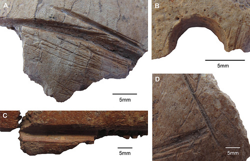
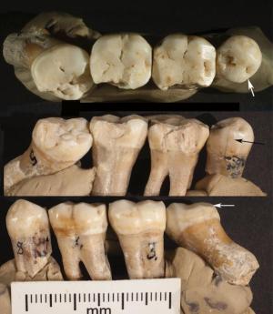
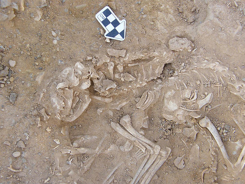
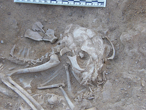
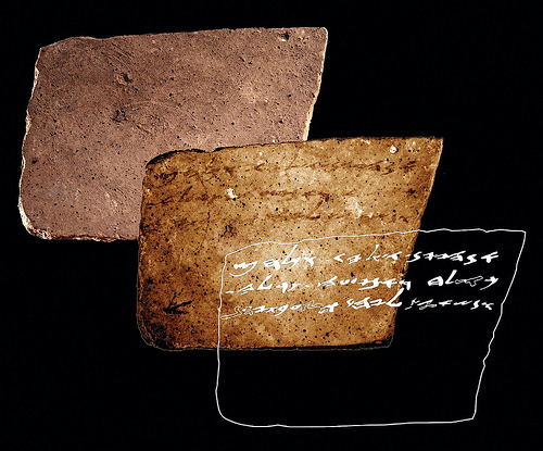
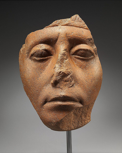
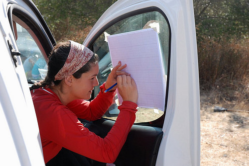
Three carved skull fragments uncovered at a Neolithic dig site in Turkey feature modifications not seen before among human remains of the time, researchers say. Thus, these modified skull fragments could point to a new “skull cult” — or ritual group — from the Neolithic period. Throughout history, people have valued skulls for different reasons, from ancestor worship to the belief that human skulls transmit protective properties. This focus on the skull has led to the establishment of the term skull cult in anthropology, and various such cults — each with characteristic modifications to skull bones — have been catalogued. Recently, Julia Gresky and colleagues observed a previously unknown type of modification in three partial skulls uncovered at Göbekli Tepe. Each skull had intentional deep incisions along its sagittal axes and one of those skulls also displayed a drilled hole in the left parietal bone, as well as red ochre remnants, the authors say. By using different microscopic techniques to analyze the fragments, Gresky et al. verified that the carvings were executed using lithic tools, thus ruling out natural causes, like animal gnawing. In addition, they were able to discount scalping as a source of the marks, due to the depth of the carvings; however, other minor cut-marks on the skulls show signs of possible defleshing, they say. More likely, the skulls were carved to venerate ancestors not long after their death, say the authors, or, to put recently “dispatched” enemies on display. These findings, published in an article about the research in Science Advances*, present the very first evidence for treatment of the dead at Göbekli Tepe.
_____________________________________
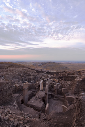
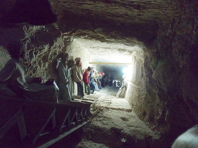
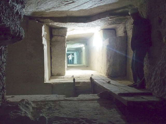
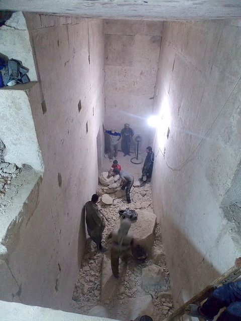
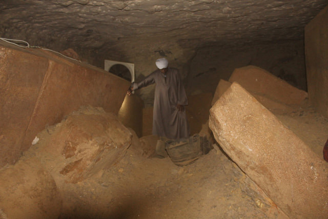
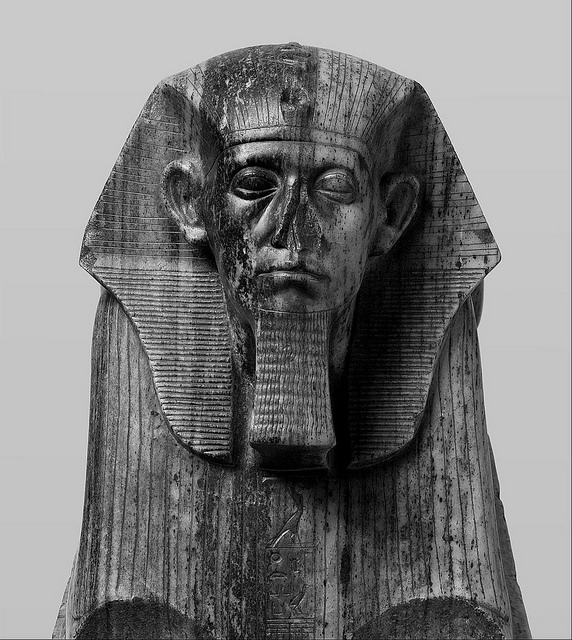
Göbekli Tepe “Southeast-Hollow.” Credit: German Archaeological Institute (DAI)
Receive 30 days free access to the popular new CuriosityStream lineup of documentaries on science, history, nature, and technology as a new Popular Archaeology premium subscriber.
This richly illustrated issue includes the following stories: Recent findings shedding new light on the whereabouts of the remains of Philip of Macedon, father of Alexander the Great; how an archaeologist-sculptor is bringing bones of the dead back to life; archaeologists uncovering town life at the dawn of civilization; an exclusive interview with internationally acclaimed archaeologist James M. Adovasio about what makes the Meadowcroft Rockshelter prominent in the ongoing search for the first Americans; what archaeologists are finding at the site of the ancient city of Gath, the home town of the biblical Philistine giant, Goliath; and how scientists are redrawing the picture of human evolution in Europe. Find it on Amazon.com.
UNIVERSITY OF KANSAS—LAWRENCE—Neanderthals treating toothaches?
A discovery of multiple toothpick grooves on teeth and signs of other manipulations by a Neanderthal of 130,000 years ago are evidence of a kind of prehistoric dentistry, according to a new study led by a University of Kansas researcher.
“As a package, this fits together as a dental problem that the Neanderthal was having and was trying to presumably treat itself, with the toothpick grooves, the breaks and also with the scratches on the premolar,” said David Frayer, professor emeritus of Anthropology. “It was an interesting connection or collection of phenomena that fit together in a way that we would expect a modern human to do. Everybody has had dental pain, and they know what it’s like to have a problem with an impacted tooth.”
The Bulletin of the International Association for Paleodontology recently published the study. The researchers analyzed four isolated but associated mandibular teeth on the left side of the Neanderthal’s mouth. Frayer’s co-authors are Joseph Gatti, a Lawrence dentist, Janet Monge, of the University of Pennsylvania; and, Davorka Radovčić, curator at the Croatian Natural History Museum.
The teeth were found at Krapina site in Croatia, and Frayer and Radovčić have made several discoveries about Neanderthal life there, including a widely recognized 2015 study published in PLOS ONE about a set of eagle talons that included cut marks and were fashioned into a piece of jewelry.
The teeth and all the Krapina Neanderthal fossils were discovered more than 100 years ago from the site, which was originally excavated between 1899-1905.
However, Frayer and Radovčić in recent years have reexamined many items collected from the site.
In this case, they analyzed the teeth with a light microscope to document occlusal wear, toothpick groove formation, dentin scratches, and ante mortem, lingual enamel fractures.
Even though the teeth were isolated, previous researchers were able to reconstruct their order and location in the male or female Neanderthal’s mouth. Frayer said researchers have not recovered the mandible to look for evidence of periodontal disease, but the scratches and grooves on the teeth indicate they were likely causing irritation and discomfort for some time for this individual.
They found the premolar and M3 molar were pushed out of their normal positions. Associated with that, they found six toothpick grooves among those two teeth and the two molars further behind them.
“The scratches indicate this individual was pushing something into his or her mouth to get at that twisted premolar,” Frayer said.
The features of the premolar and third molar are associated with several kinds of dental manipulations, he said. Mostly because the chips of the teeth were on the tongue side of the teeth and at different angles, the researchers ruled out that something happened to the teeth after the Neanderthal died.
_____________________________________
Three views of the four articulated teeth making up KDP 20; (a) occlusal view showing lingually placed mesial interproximal wear facet on P4 (arrow) and buccal wear on M3; (b) lingual view showing a mesially placed interproximal wear facet on P4 (arrow), chips from lingual faces of all teeth and rotated, partially impacted M3; (c) buccal view showing rotated buccal face of M3 (arrow) and hypercementosis on its root. Credit: David Frayer, University of Kansas
_________________________________________________
Toothpick grooves, irregular interproximal facets and other anomalies on the left P4; (a) mesial face with a small toothpick groove on the mesial-lingual edge. Above it is a very lingually positioned interproximal wear facet (arrow); (b) distal surface with a deep toothpick groove and an interproximal wear facet that has an abnormal lingual location (arrow); (c) chips from the occlusal/lingual margin; (d) probing striations on the mesial/buccal facet. Credit: David Frayer, University of Kansas
Past research in the fossil record has identified toothpick grooves going back almost 2 million years, Frayer said. They did not identify what the Neanderthal would have used to produce the toothpick grooves, but it possibly could have been a bone or stem of grass.
“It’s maybe not surprising that a Neanderthal did this, but as far as I know, there’s no specimen that combines all of this together into a pattern that would indicate he or she was trying to presumably self-treat this eruption problem,” he said.
The evidence from the toothpick marks and dental manipulations is also interesting in light of the discovery of the Krapina Neanderthals’ ability to fashion eagle talons fashioned into jewelry because people often think of Neanderthals as having “subhuman” abilities.
“It fits into a pattern of a Neanderthal being able to modify its personal environment by using tools,” Frayer said, “because the toothpick grooves, whether they are made by bones or grass stems or who knows what, the scratches and chips in the teeth, they show us that Neanderthals were doing something inside their mouths to treat the dental irritation. Or at least this one was.”
Receive 30 days free access to the popular new CuriosityStream lineup of documentaries on science, history, nature, and technology as a new Popular Archaeology premium subscriber.
This richly illustrated issue includes the following stories: Recent findings shedding new light on the whereabouts of the remains of Philip of Macedon, father of Alexander the Great; how an archaeologist-sculptor is bringing bones of the dead back to life; archaeologists uncovering town life at the dawn of civilization; an exclusive interview with internationally acclaimed archaeologist James M. Adovasio about what makes the Meadowcroft Rockshelter prominent in the ongoing search for the first Americans; what archaeologists are finding at the site of the ancient city of Gath, the home town of the biblical Philistine giant, Goliath; and how scientists are redrawing the picture of human evolution in Europe. Find it on Amazon.com.
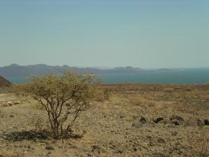
UNIVERSITY OF UTAH—The shores of Lake Turkana, in Kenya, are dry and inhospitable, with grasses as the dominant plant type. It hasn’t always been that way. Over the last four million years, the Omo-Turkana basin has seen a range of climates and ecosystems, and has also seen significant steps in human evolution. Scientists previously thought that long-term drying of the climate contributed to the growth of grasslands in the area and the rise of large herbivores, which in turn may have shaped how humans developed. It’s tough to prove that hypothesis, however, because of the difficulty of reconstructing four million years of climate data.
Researchers from the University of Utah have found a better way. By analyzing isotopes of oxygen preserved in herbivore teeth and tusks, they can quantify the aridity of the region and compare it to indicators of plant type and herbivore diet. The results, published in a study issued through the Proceedings of the National Academy of Sciences (PNAS) show that, unexpectedly, no long-term drying trend was associated with the expansion of grasses and grazing herbivores. Instead, variability in climate events, such as rainfall timing, and interactions between plants and animals may have had more influence on our ancestors’ environment. This shows that the expansion of grasslands isn’t solely due to drought, but more complex climate factors are at work, both for modern Africans now and ancient Africans in the Pleistocene.
______________________________________
A view of the Lake Turkana environment as it exists today. AdamPG, Wikimedia Commons
Receive 30 days free access to the popular new CuriosityStream lineup of documentaries on science, history, nature, and technology as a new Popular Archaeology premium subscriber.
This richly illustrated issue includes the following stories: Recent findings shedding new light on the whereabouts of the remains of Philip of Macedon, father of Alexander the Great; how an archaeologist-sculptor is bringing bones of the dead back to life; archaeologists uncovering town life at the dawn of civilization; an exclusive interview with internationally acclaimed archaeologist James M. Adovasio about what makes the Meadowcroft Rockshelter prominent in the ongoing search for the first Americans; what archaeologists are finding at the site of the ancient city of Gath, the home town of the biblical Philistine giant, Goliath; and how scientists are redrawing the picture of human evolution in Europe. Find it on Amazon.com.
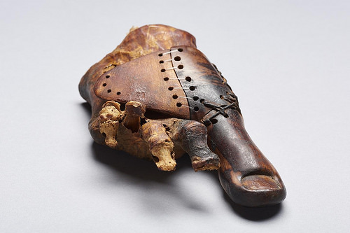
UNIVERSITY OF BASEL—It is likely to be one of the oldest prosthetic devices in human history: Together with other experts, Egyptologists from the University of Basel have reexamined an artificial wooden big toe. The find is almost 3000 years old and was discovered in a female burial from the necropolis of Sheikh ´Abd el-Qurna close to Luxor. This area is currently being studied using state-of-the-art methods.
The international team investigated the one-of-a-kind prosthesis using modern microscopy, X-ray technology, and computer tomography. They were able to show that the wooden toe was refitted several times to the foot of its owner, a priest’s daughter. The researchers also newly classified the used materials and identified the method with which the highly developed prosthesis was produced and utilized. Experts from the Egyptian Museum in Cairo – where the prosthetic device was brought to after it had been found – and the Institute of Evolutionary Medicine at the University of Zurich were also involved in this study.
The artificial toe from the early first millennium BC testifies to the skills of an artisan who was very familiar with the human physiognomy. The technical know-how can be seen particularly well in the mobility of the prosthetic extension and the robust structure of the belt strap. The fact that the prosthesis was made in such a laborious and meticulous manner indicates that the owner valued a natural look, aesthetics and wearing comfort and that she was able to count on highly qualified specialists to provide this.
___________________________________
Toe prosthesis of a female burial from the Theban tomb TT95, early first millennium BC. Egyptian Museum Cairo. Credit: University of Basel, LHTT. Image: Matja Kačičnik
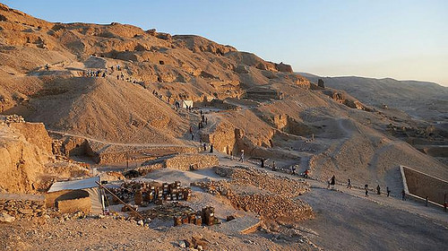
The prosthesis from the Early Iron Age was found in a plundered shaft tomb that was cut into the bedrock of an older, long time idle burial chapel at the graveyard hill of Sheikh ´Abd el-Qurna to the west of Luxor. This chapel belongs to a group of monumental rock-cut tombs from the late 15th century BC which were built for a small upper class that was close to the royal family. Since the end of 2015, the University of Basel has been studying this ancient Egyptian elite cemetery, its long history of usage, and surroundings.
For this project, funded by the Swiss National Science Foundation, microanalytic, scientifically oriented methods, as well as precision technology for surveying and photography were used. The researchers are looking into the materiality of archaeological remains and are thus gaining insight into the life histories of building structures and objects. These material biographies can provide information about the manufacturing practices, usages, personal skills, habits and preferences of people who were in contact with these objects.
______________________________________
A view of the excavation area in the cemetery of Sheikh ´Abd el-Qurna. Credit: University of Basel, LHTT. Image: Matja Kačičnik
The oldest known tombs from Sheikh ´Abd el-Qurna date back to the early second millennium BC. The cemetery saw its heyday in the 15th century BC. However, many of these rock-cut structures were reused and in parts remodeled several times for burials during the first millennium BC. Much later, they served as dwellings mostly for locals – a process that began with the early Christian hermits and only ended in the early 20th century.
Together with the experts for geodesy and geology from the ETH Zurich, the Basel team of archaeologists is scientifically assessing the natural and artificial structures of the excavation area and its surroundings. The specialists are currently developing geometric precise digital elevation, landscape, and architecture models for this area. These will then be combined to an archaeological and geological 3-D map that will illustrate the morphology of the terrain as well as the investigated subterranean structures. On that basis, the researchers want to reconstruct and simulate the development of the cemetery and its use phases.
Receive 30 days free access to the popular new CuriosityStream lineup of documentaries on science, history, nature, and technology as a new Popular Archaeology premium subscriber.
This richly illustrated issue includes the following stories: Recent findings shedding new light on the whereabouts of the remains of Philip of Macedon, father of Alexander the Great; how an archaeologist-sculptor is bringing bones of the dead back to life; archaeologists uncovering town life at the dawn of civilization; an exclusive interview with internationally acclaimed archaeologist James M. Adovasio about what makes the Meadowcroft Rockshelter prominent in the ongoing search for the first Americans; what archaeologists are finding at the site of the ancient city of Gath, the home town of the biblical Philistine giant, Goliath; and how scientists are redrawing the picture of human evolution in Europe. Find it on Amazon.com.
NORTH CAROLINA STATE UNIVERSITY—Skeletal evidence shows that, hundreds of years after the Roman Republic conquered most of the Mediterranean world, coastal communities in what is now south and central Italy still bore distinct physical differences to one another – though the same could not be said of the area around Rome itself.
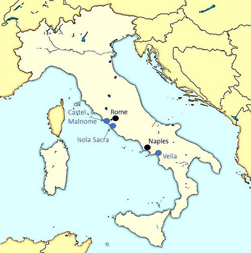
Using state-of-the-art forensic techniques, anthropologists from North Carolina State University and California State University, Sacramento examined skulls from three imperial Roman cemeteries: 27 skulls from Isola Sacra, on the coast of central Italy; 26 from Velia, on the coast of southern Italy; and 20 from Castel Malnome, on the outskirts of the city of Rome. The remains at the cemeteries in both Isola Sacra and Velia belonged to middle-class merchants and tradesmen, while those from Castel Malnome belonged to manual laborers. All of the remains date from between the first and third centuries A.D.
The researchers took measurements of 25 specific points on each skull using a “digitizer,” which is basically an electronic stylus that records the coordinates of each point. This data allowed them to perform shape analysis on the skulls, relying on “geometric morphometrics” — a field of study that characterizes and assesses biological forms.
“We found that there were significant cranial differences between the coastal communities, even though they had comparable populations in terms of class and employment,” says Ann Ross, a professor of anthropology at NC State and co-author of a paper on the work.
“We think this is likely due to the fact that the area around Velia had a large Greek population, rather than an indigenous one,” says Samantha Hens, a professor of biological anthropology at Sacramento State and lead author of the paper.
_____________________________________
A student uses a digitizer to record geometric morphometric sites on a skull. Credit: NC State University
A map showing the locations of the three imperial Roman cemeteries in relation to modern day Rome and Naples. Credit: Samantha Hens, California State University, Sacramento
In addition, the skulls from Castel Malnome had more in common with both coastal sites than the coastal sites had with each other.
“This likely highlights the heterogeneity of the population near Rome, and the influx of freed slaves and low-paid workers needed for manual labor in that area,” Hens says.
“Researchers have used many techniques — from linguistics to dental remains – to shed light on how various peoples moved through the Roman Republic and the Roman Empire,” Ross says. “But this is the first study we know of in which anyone has used geometric morphometrics to evaluate imperial Roman remains.
“That’s important because geometric morphometrics offers several advantages,” Ross says. “It includes all geometric information in three-dimensional space rather than statistical space, it provides more biological information, and it allows for pictorial visualization rather than just lists of measurements.”
“The patterns of similarities and differences that we see help us to reconstruct past population relationships,” Hens says. “Additionally, these methods allow us to identify where the shape change is occurring on the skull, for example, in the face, or braincase, which gives us a view into what these people actually looked like.”
Receive 30 days free access to the popular new CuriosityStream lineup of documentaries on science, history, nature, and technology as a new Popular Archaeology premium subscriber.
This richly illustrated issue includes the following stories: Recent findings shedding new light on the whereabouts of the remains of Philip of Macedon, father of Alexander the Great; how an archaeologist-sculptor is bringing bones of the dead back to life; archaeologists uncovering town life at the dawn of civilization; an exclusive interview with internationally acclaimed archaeologist James M. Adovasio about what makes the Meadowcroft Rockshelter prominent in the ongoing search for the first Americans; what archaeologists are finding at the site of the ancient city of Gath, the home town of the biblical Philistine giant, Goliath; and how scientists are redrawing the picture of human evolution in Europe. Find it on Amazon.com.
KU LEUVEN—DNA found at archaeological sites reveals that the origins of our domestic cat are in the Near East and ancient Egypt. Cats were domesticated by the first farmers some 10,000 years ago. They later spread across Europe and other parts of the world via the trade hub of Egypt. The DNA analysis also revealed that most of these ancient cats had stripes: spotted cats were uncommon until the Middle Ages.
Five subspecies of the wildcat Felis silvestris are known today. All skeletons look exactly alike and are indistinguishable from that of our domestic cat. As a result, it’s impossible to see with the naked eye which of these subspecies was domesticated in a distant past. Paleogeneticist Claudio Ottoni and his colleagues from KU Leuven (University of Leuven) and the Royal Belgian Institute of Natural Sciences set out to look for the answer in the genetic code. They used the DNA from bones, teeth, skin, and hair of over 200 cats found at archaeological sites in the Near East, Africa, and Europe. These remains were between 100 and 9,000 years old.
The DNA analysis revealed that all domesticated cats descend from the African wildcat or Felis silvestris lybica, a wildcat subspecies found in North Africa and the Near East. Cats were domesticated some 10,000 years ago by the first farmers in the Near East. The first agricultural settlements probably attracted wildcats because they were rife with rodents. The farmers welcomed the wildcats as they kept the stocks of cereal grain free from vermin. Over time, man and animal grew closer, and selection based on behaviour eventually led to the domestication of the wildcat.
Migrating farmers took the domesticated cat with them. At a later stage, the cats also spread across Europe and elsewhere via the trade hub of Egypt. Used to fight vermin on Egyptian trade ships, the cats travelled to large parts of South West Asia, Africa, and Europe. Bones of cats with an Egyptian signature have even been found at Viking sites near the Baltic Sea.
“It’s still unclear, however, whether the Egyptian domestic cat descends from cats imported from the Near East or whether a separate, second domestication took place in Egypt,” says researcher Claudio Ottoni. “Further research will have to show.” The scientists were also able to determine the coat pattern based on the DNA of the old cat bones and mummies. They found that the striped cat was much more common in ancient times. This is also illustrated by Egyptian murals: they always depict striped cats. The blotched pattern did not become common until the Middle Ages.
The study was led by the Centre for Archaeological Sciences at KU Leuven (University of Leuven), Belgium, and by the Royal Belgian Institute of Natural Sciences, in collaboration with the genetics lab at the Institut Jacques Monod in Paris and dozens of specialists from around the world who provided cat bones retrieved from archaeological sites.
___________________________________________
Receive 30 days free access to the popular new CuriosityStream lineup of documentaries on science, history, nature, and technology as a new Popular Archaeology premium subscriber.
This richly illustrated issue includes the following stories: Recent findings shedding new light on the whereabouts of the remains of Philip of Macedon, father of Alexander the Great; how an archaeologist-sculptor is bringing bones of the dead back to life; archaeologists uncovering town life at the dawn of civilization; an exclusive interview with internationally acclaimed archaeologist James M. Adovasio about what makes the Meadowcroft Rockshelter prominent in the ongoing search for the first Americans; what archaeologists are finding at the site of the ancient city of Gath, the home town of the biblical Philistine giant, Goliath; and how scientists are redrawing the picture of human evolution in Europe. Find it on Amazon.com.
WEIZMANN INSTITUTE OF SCIENCE—Gihon Spring, just downhill from the ancient city of Jerusalem, was crucial to the survival of its inhabitants, and archaeologists had uncovered the remains of a massive stone tower built to guard this vital water supply. Based on pottery and other regional findings, the archaeologists had originally assigned it a date of 1,700 BCE. But new research conducted at the Weizmann Institute of Science provides conclusive evidence that the stones at the base of the tower were laid nearly 1,000 years later. Among other things, the new results highlight the contribution of advanced scientific dating methods to understanding the history of the region.
Dr. Elisabetta Boaretto, Head of the Weizmann Institute of Science’s D-REAMS Radiocarbon Dating Laboratory and track leader within the Max Planck-Weizmann Center for Integrative Archaeology and Anthropology, had the opportunity to date the tower as part of her ongoing cooperative research projects with the Israel Antiquity Authority (IAA). Since 2012, Dr. Joe Uziel and Nahshon Szanton of the IAA, in continuing the excavations around the tower, have discovered that the base of the tower was not built on bedrock. “The boulders in the tower’s base, in and of themselves,” explains Boaretto, “do not yield any information other than the fact that whoever placed them there had the ability to maneuver such heavy stones. But underneath the boulders, the soil exhibits the layers typical of archaeological strata, and these can reveal the latest date that the site was occupied before the tower was built.”
The unique and methodical approach of the D-REAMS lab team begins by planning and executing the field sampling and excavation from the beginning – together with the site archaeologists. “Getting one’s hands dirty is all part of building a reliable chronology,” says Boaretto. During field work conducted with the archaeologists and later in her laboratory with postdoctoral fellow Dr. Johanna Regev, Boaretto identified several clearly-delineated strata. From these, they carefully collected remains of charcoal, seeds and bones – organic matter that can be definitively dated through radiocarbon dating.
The first dating was conducted on mid-to-lower levels of sediment, and these dates indeed agreed with those originally proposed. “But there was another half-meter of sediment between the material we had dated and the large cornerstone,” says Boaretto. “At a glance, we thought this might represent another few hundred years before the stone was placed.” The presence of separate, sequential layers, which they identified using microarchaeological tools and radiocarbon dating, enabled the researchers to attach dates to the strata just below the tower.
The radiocarbon dating method is based on counting the radioactive 14C atoms in a sample. These carbon atoms are found in all living things in a small, but stable ratio to that of regular carbon, and they begin to decay at a known rate after death. At the Weizmann Institute of Science, the count of 14C atoms in a sample is performed with an accelerator, so it can return highly accurate results on something as small as a seed.
The date revealed by this radiocarbon dating was sometime around 800-900 BCE. That is nearly 1,000 years later than thought, and it moves the building of the tower to another historical period entirely, from the Middle Bronze Age to the Iron Age.
____________________________________
Recently uncovered remains of a massive stone tower built to guard Gihon Spring—a vital water supply just downhill from the ancient city of Jerusalem. Cedit: Weizmann Institute of Science
_______________________________________________
To complete the study, Boaretto and her team asked whether any explanation could allow the tower to have been built earlier – repairs, for example – but the presence of the large boulders sitting above layers of earth containing the remains of everyday activities would appear to be fairly conclusive evidence that the later date is the correct one. Boaretto: “The conclusive, scientific dating of this massive tower, placing it in a later era than was presumed, will have repercussions for other attempts to date construction and occupation in ancient Jerusalem.”
Dr. Elisabetta Boaretto’s research is supported by the Dangoor Accelerator Mass Spectrometer Laboratory.
The Weizmann Institute of Science in Rehovot, Israel, is one of the world’s top-ranking multidisciplinary research institutions. Noted for its wide-ranging exploration of the natural and exact sciences, the Institute is home to scientists, students, technicians and supporting staff. Institute research efforts include the search for new ways of fighting disease and hunger, examining leading questions in mathematics and computer science, probing the physics of matter and the universe, creating novel materials and developing new strategies for protecting the environment.
_______________________________________________
Receive 30 days free access to the popular new CuriosityStream lineup of documentaries on science, history, nature, and technology as a new Popular Archaeology premium subscriber.
This richly illustrated issue includes the following stories: Recent findings shedding new light on the whereabouts of the remains of Philip of Macedon, father of Alexander the Great; how an archaeologist-sculptor is bringing bones of the dead back to life; archaeologists uncovering town life at the dawn of civilization; an exclusive interview with internationally acclaimed archaeologist James M. Adovasio about what makes the Meadowcroft Rockshelter prominent in the ongoing search for the first Americans; what archaeologists are finding at the site of the ancient city of Gath, the home town of the biblical Philistine giant, Goliath; and how scientists are redrawing the picture of human evolution in Europe. Find it on Amazon.com.
AMERICAN FRIENDS OF TEL AVIV UNIVERSITY—Using advanced imaging technology, Tel Aviv University researchers have discovered a hitherto invisible inscription on the back of a pottery shard that has been on display at The Israel Museum for more than 50 years.
The ostracon (ink-inscribed pottery shard) was first found in poor condition in 1965 at the desert fortress of Arad. It dates back to ca. 600 BCE, the eve of the kingdom of Judah’s destruction by Nebuchadnezzar. The inscription on its front side, opening with a blessing by Yahweh, discusses money transfers and has been studied by archaeologists and biblical scholars alike.
“While its front side has been thoroughly studied, its back was considered blank,” said Arie Shaus of TAU’s Department of Applied Mathematics, one of the principal investigators of the study published today in PLOS ONE. The study can be found at http://journals.plos.org/plosone/article?id=10.1371/journal.pone.0178400.
“Using multispectral imaging to acquire a set of images, Michael Cordonsky of TAU’s School of Physics noticed several marks on the ostracon’s reverse side. To our surprise, three new lines of text were revealed,” Shaus said.
The researchers were able to decipher 50 characters, comprising 17 words, on the back of the ostracon. “The content of the reverse side implies it is a continuation of the text on the front side,” said Shira Faigenbaum-Golovin of TAU’s Department of Applied Mathematics, another principal investigator of the study.
The multidisciplinary research was conducted by Faigenbaum-Golovin, Shaus, and Barak Sober, all doctoral students in TAU’s Department of Applied Mathematics, and by Dr. Anat Mendel-Geberovich of TAU’s Department of Archaeology. Additional collaborators include Prof. David Levin and Prof. Eli Turkel of TAU’s Department of Applied Mathematics, Prof. Benjamin Sass of TAU’s Department of Archaeology, as well as Michael Cordonsky and Prof. Murray Moinester of TAU’s School of Physics. The research team was co-led by Prof. Eli Piasetzky of TAU’s School of Physics and Prof. Israel Finkelstein of TAU’s Department of Archaeology.
“Using multispectral imaging, we were also able to significantly improve the reading of the front side, adding four ‘new’ lines,” said Sober.
_____________________________________
Above: The inscription found on reverse of ostraca at Arad. Credit: American Friends of Tel Aviv University (AFTAU)
_______________________________________
A request for more wine
“Tel Arad was a military outpost—a fortress at the southern border of the kingdom of Judah—and was populated by 20 to 30 soldiers,” said Dr. Mendel-Geberovich. “Most of the ostraca unearthed at Arad are dated to a short time span during the last stage of the fortress’s history, on the eve of the kingdom’s destruction in 586 BCE by Nebuchadnezzar. Many of these inscriptions are addressed to Elyashiv, the quartermaster of the fortress. They deal with the logistics of the outpost, such as the supply of flour, wine, and oil to subordinate units.”
“The new inscription begins with a request for wine, as well as a guarantee for assistance if the addressee has any requests of his own,” said Shaus. “It concludes with a request for the provision of a certain commodity to an unnamed person, and a note regarding a ‘bath,’ an ancient measurement of wine carried by a man named Ge’alyahu.”
“The newly revealed inscription features an administrative text, like most of the Arad inscriptions,” said Dr. Mendel-Geberovich. “Its importance lies in the fact that each new line, word, and even a single sign is a precious addition to what we know about the First Temple period.”
“On a larger scale, our discovery stresses the importance of multispectral imaging to the documentation of ostraca,” said Faigenbaum-Golovin. “It’s daunting to think how many inscriptions, invisible to the naked eye, have been disposed of during excavations.”
“This is ongoing research,” concluded Sober. “We have at our disposal several additional alterations and expansions of known First Temple-period ostraca. Hence, the future may hold additional surprises.”
Receive 30 days free access to the popular new CuriosityStream lineup of documentaries on science, history, nature, and technology as a new Popular Archaeology premium subscriber.
This richly illustrated issue includes the following stories: Recent findings shedding new light on the whereabouts of the remains of Philip of Macedon, father of Alexander the Great; how an archaeologist-sculptor is bringing bones of the dead back to life; archaeologists uncovering town life at the dawn of civilization; an exclusive interview with internationally acclaimed archaeologist James M. Adovasio about what makes the Meadowcroft Rockshelter prominent in the ongoing search for the first Americans; what archaeologists are finding at the site of the ancient city of Gath, the home town of the biblical Philistine giant, Goliath; and how scientists are redrawing the picture of human evolution in Europe. Find it on Amazon.com.
Popular Archaeology Magazine is pleased to announce the release of the Summer 2017 Issue. In this issue, the following fascinating articles are available:
1. The Extraordinary Case of the San Diego Mastodon (Premium Article)
The in-depth story about the controversial discovery of a 130,000-year-old human presence in Southern California.
2. A Pharaoh’s Massive Tomb Unveiled (Free to the public)
For the first time, visitors to Egypt will be able to descend 45 meters underground into the ancient tomb of the most famous pharaoh of Abydos.
3. Rising Star: New Answers, New Questions (Premium Article)
Is Africa’s largest trove of early human remains shedding game-changing light on human origins, or muddying the water?
4. Discoveries at El Palenque (Premium Article)
Archaeologists have uncovered the oldest multifunctional royal palace in Mexico’s Oaxaca Valley.
5. The Age of Little Foot (Premium Article)
Scientists continue the debate surrounding the true age of the famous fossil skeleton discovered at Sterkfontein Caves in South Africa.
6. The Lost Cities of Ethiopia (Free to the public)
Archaeologists and scholars crack the code of the historic Fra Mauro map to find long lost medieval cities in Ethiopia.
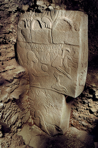
And coming soon: The astounding discoveries at Göbekli Tepe
There are amazing discoveries being made almost every day across the world. This issue covers only a few of the biggest stories of recent months. We hope you will enjoy the content, and please feel free to write us at [email protected] if you have any questions, concerns, or suggestions.
Finally, if you are not a premium subscriber, we invite you to join for access to all of our premium articles, and to take advantage of our special offer for exclusive 30 days free access to all of the popular documentary video streaming service films offered at CuriosityStream.
AUSTRALIAN NATIONAL UNIVERSITY—Archaeologists at The Australian National University (ANU) and the University of Sydney have provided a window into one of the most exciting periods in human history—the transition between Neanderthals and modern humans.
An archaeological dig in a cave in the Moravian region of the Czech Republic has provided a timeline of evidence from 10 sedimentary layers spanning 28,000 to 50,000 years ago. This is the period when our modern human ancestors first arrived in Europe.
The dig, in a cave near the Czech border with Austria and around 150kms north of Vienna, has unearthed over 20,000 animal bones as well as stone tools, weapons and an engraved bone bead that is the oldest of its kind in Central Europe.
ANU archaeologist Dr Duncan Wright said the project was so important because it gives some of the earliest evidence of modern human activity in the region. This was a period when humans were moving substantial distances and bringing with them portable art objects.
“In the early layers the items we’ve found are locally made flakes, possibly used by small communities living and hunting in the vicinity to kill animals or prepare food, but around 40,000 years ago we start to see objects coming from long distances away,” Dr Wright said.
“Dating from this same time we unearthed a bead made from mammal bone. This is the oldest portable art object of its type found anywhere in central Europe and provides evidence of social signalling, quite possibly used as a necklace to mark the identity of the wearer.
“So between these two periods, we’ve either seen a change in behaviour and human movement or possibly even a change in species.”
Archaeologist Ladislav Nejman of the University of Sydney said one of the biggest questions is the beginnings of human exploration of this landscape by Homo sapiens who arrived in this area for the first time. “We’ve found that somewhere between 40-48,000 years ago people became highly mobile,” Dr Nejman said.
“Instead of moving short distances near the cave where they lived, they were walking for hundreds of kilometres quite often. We know that because we found various artefacts where the raw material comes from 100-200 kilometres away.
“The artefacts were also made of different materials from different regions. Some from the North-West, some from the North, some from the East.”
However in layer 10, which represents an earlier time period between 48-45,000 years ago, all the recovered stone artefacts were made using local raw material, which indicates that the high residential mobility came later.
_____________________________________
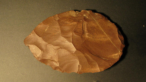
This is a stone tool thought to be a speartip made from radiolarite sourced over 100km to the east of the cave. Image: Miroslav Kralík
Dr Nejman said the study also revealed valuable new information about the climate of the region.
“We haven’t had such a long sequence of sedimentary layers before that we could test,” he said.
“The climate changed quite often from warmer to colder, and vice versa, but at all times it was much colder than the interglacial period that we have lived in for the past 10,000 years.”
Samples from the site have been sent through for analysis using a new technique, called ancient sediment DNA analysis. This is the first scientific method that can detect which species were present even without the bones of these species. It tests remnant DNA preserved in the sediment.
Dr Wright said the results will shed new light on a period of transition between two species of humans and also give clearer evidence about the activities of our modern human ancestors in a period and region where little is known.
“We can tell by the artefacts that small groups of people camped at this cave. This was during glacial periods suggesting they were well adapted to these harsh conditions” Dr Wright said.
“It’s quite possible that the two different species of humans met in this area.”
Receive 30 days free access to the popular new CuriosityStream lineup of documentaries on science, history, nature, and technology as a new Popular Archaeology premium subscriber.
This richly illustrated issue includes the following stories: Recent findings shedding new light on the whereabouts of the remains of Philip of Macedon, father of Alexander the Great; how an archaeologist-sculptor is bringing bones of the dead back to life; archaeologists uncovering town life at the dawn of civilization; an exclusive interview with internationally acclaimed archaeologist James M. Adovasio about what makes the Meadowcroft Rockshelter prominent in the ongoing search for the first Americans; what archaeologists are finding at the site of the ancient city of Gath, the home town of the biblical Philistine giant, Goliath; and how scientists are redrawing the picture of human evolution in Europe. Find it on Amazon.com.
Julie Masis is a freelance journalist based in Cambodia. Her stories have appeared in the Christian Science Monitor, the Guardian, the Boston Globe, Science magazine and in other publications.
The tomb of King Senwosret III, one of the most renowned pharaohs of ancient Egypt’s Middle Kingdom, is expected to open soon, allowing tourists to appreciate the architecture of Egyptian builders who constructed the burial complex almost four thousand years ago, according to Dr. Josef Wegner, Associate Curator of the Egyptian Section of the University of Pennsylvania Museum of Archaeology and Anthropology (Penn Museum). He has been excavating in Abydos, where the tomb is located and one of the oldest cities of ancient Egypt, for decades.
Dated to 1850 BC, it is the largest tomb at Abydos. The tomb measures 200 meters in length and 45 meters deep. To visualize how massive this is, one would need to imagine a 13 story building underground. “The architecture is amazing,” says Wegner. “It’s like going into a pyramid. It’s architecture is symbolic – depicting the sacred journey into the afterlife.”
The entrance of the tomb faces westwards (symbolizing death, because the sun sets in the west) and then the underground complex curls under a sacred natural mountain, anciently known as Anubis-Mountain, to face the eastern horizon, the direction from which the sun rises, symbolizing rebirth, explained Wegner. “For the Egyptians, that the sun vanishes in the west and magically rises in the east is one of the secrets of the universe, giving them the power of rejuvenation,” he said.
The burial complex features chambers with ceilings six meters high, as well as narrow passageways with blocking stones. The chambers are connected to each other with sloping passages. To navigate the tomb structure, archaeologists, while exploring it, had to slide down at approximately a 30 degree angle. Some blocking stones in these passages weigh as much as 40 to 50 tons. The air inside is stuffy, which makes some people uncomfortable, Wegner admitted. “Some people get a little nervous going into it. When we first opened it, it was full of debris, so we had to crawl on our hands and knees and slither like a snake.”
Luckily, tourists will not have to slither like snakes when they visit the tomb. Stairs with handrails, lights, and a ventilation system were installed and debris and broken blocking stones were removed to make it possible for visitors to walk upright. Work is currently underway to complete the signage in the tombs, and to prepare a parking area for buses, Wegner said.
The significance of the tomb
Although first discovered and explored in 1901 by Arthur Weigall, the tomb was not systematically excavated until Wegner and a team reopened it in 2005 with a plan for full excavation, publication and restoration of the tomb. Since then, more detailed features of the tomb structure have been revealed. It was found to be devoid of wall decoration, but its interior was lined with well-dressed masonry of Tura limestone and red Aswan quartzite. The burial chamber contained the broken remains of the king’s granite sarcophagus and canopic box, and was protected by an elaborate system of massive stone blocks and architectural techniques for concealing the royal burial’s location. Several of the blocking stones weighed over 50 tons, designed to prevent access by tomb robbers into the burial chamber itself.
Most significantly, the Senwosret III tomb is now the first known example of a hidden royal tomb, representing a change from the ancient traditional concept of the royal pyramid to that of a royal subterranean complex like those of the later royal burials in the Valley of the Kings at Thebes. Describing the tomb, Wegner and researchers write that “the tomb itself extends beneath the peak of Anubis-Mountain which serves as a substitute for the built pyramid. This name occurs on many clay impressions produced by a necropolis seal that was used extensively in a variety of administrative and ceremonial activities at the tomb site.” The tomb is thus a massively monumental example of a major shift in ancient Egyptian royal burial practices.
__________________________________
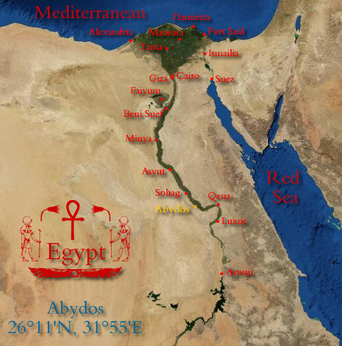
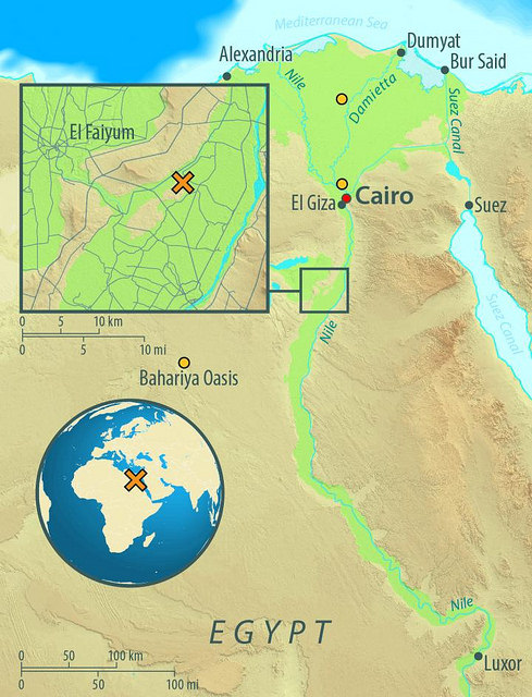
Location of Abydos in relation to other ancient sites in Egypt.
__________________________________
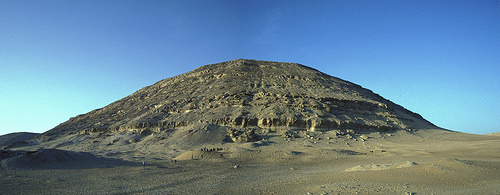
Panorama of the landscape of the Anubis-Mountain necropolis. Courtesy Josef Wegner and the Penn Museum
_____________________________________
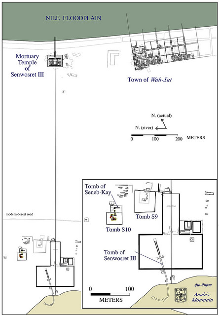
Overall plan of the complex of Senwosret III at South Abydos. Courtesy Josef Wegner and the Penn Museum
_______________________________________________
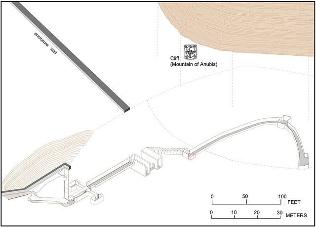
Cut-away view of the Senwosret III tomb. Courtesy Josef Wegner and the Penn Museum
Above and below: Views within the newly revealed massive tomb complex of Senwosret III. Note the remarkable interior of well-dressed masonry. Courtesy Josef Wegner and the Penn Museum
Red Aswan quartzite is a major material feature of the tomb. Courtesy Josef Wegner and the Penn Museum
Much is known about King Senwosret from inscriptions on ancient stone stelae. According to monuments he had erected during his reign, he expanded Egypt’s territory further south, more than any previous ruler, said Adela Oppenheim, a curator in the Egyptian Art Department at the Metropolitan Museum of Art in New York. It set the pace for his followers. “He said that any son who does not keep this border is not his son,” added Oppenheim. He initiated military campaigns in Nubia, an ancient region that spans southern Egypt and northern Sudan. He also built temples, monuments and fortresses (most of which were flooded when the Egyptians built the Aswan Dam in the 1960s), added Wegner.
It is believed that Senwosret III lived between 1878 BC and 1840 BC and that he was the son of Senwosret II, although this is not proven, according to Oppenheim. He had many wives, although it is not known how many.
Historians know what Senwosret III looked like because sculptures of him have survived, including two originals outside of Egypt at the Metropolitan museum in New York. Interestingly, he is the first ancient Egyptian pharaoh who was sculpted as an older man, without a smile on his face, said Oppenheim. “During this period, there was a radical change in how the king was depicted. He is depicted as if he has signs of aging. He is shown frowning. He has wrinkles on his forehead.” The reasons for this are not clear, but some historians say that perhaps this is because Egypt was enduring difficult times during Senwosret’s reign. However, Oppenheim believes that the sculptors were simply trying to show that the pharaoh had the wisdom that comes with age.
Was King Senwosret III’s body actually buried in the Abydos tomb?
Senwosret had two burial places prepared for himself – a pyramid at Dashur, near Cairo, where he also erected pyramids for his mother, his chief wife and other royal women – and the tomb at Abydos much farther south, which today is an eight hour drive from the Egyptian capital.
But which one was the actual burial place of the king?
While Senwosret III’s mummy was never found, historians are almost certain that he was not buried in the pyramid in Dashur – because archaeologists did not find any pottery or debris, or evidence that a sarcophagus was ever placed there, said Openheim, who is also the co-director of the excavation of the Dashur pyramid of Senwosret III.
In Abydos, on the other hand, archaeologists did find fragments of stone vessels that typically would have been laid in a royal tomb, indicating that the pharaoh was buried there, Wegner said. But no mummy. According to Wegner, it may have been destroyed when ancient robbers were searching for other valuables.
Other tombs to open to the public
In addition to King Senwosret’s tomb, which is the largest tomb in Abydos, visitors will also have access to three other ancient burial places.
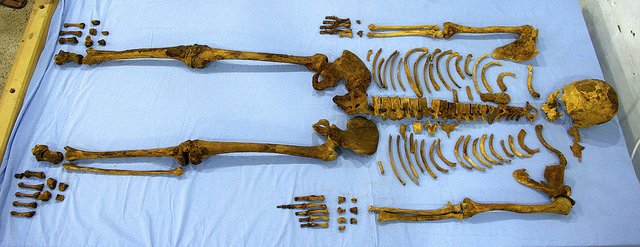
One is the smaller tomb of King Senebkay, where visitors will be able to see the skeletal remains of the king who died around 1650 BC, about two centuries after King Senwosret. Unlike King Senwosret, about whom historians know much from ancient inscriptions, virtually the only information that we have about King Senebkay comes from his tomb. The king’s bones are marked with injuries that ended his life, Wegner said. Archaeologists discovered cut marks on the king’s feet and ankles (which suggest that he was attacked from below, perhaps while he was mounted on a horse), as well as injuries to his skull. (It is suggested that he was killed by axe blows to the head after he fell to the ground.) “It is the earliest king whose physical remains indicate that he died in a battle,” Wegner said.*
Unlike King Senwosret’s tomb which is not decorated, King Senebkay’s tomb is adorned with hieroglyphics, Wegner said.
Two tombs of brother kings King Neferhotep I and King Sobekhotep IV will also become accessible to the public, Wegner added. In ancient times, these two tombs probably had small pyramids, although these pyramids have not survived, Wegner said. He explained that the design of the tombs indicate that they were once capped by a superstructure.
In all, the Abydos necropolis contains the tombs of at least 12 kings, “a whole forgotten dynasty of kings,” with the tomb of King Senwosret III being the oldest and the largest, said Wegner.
The tombs at Abydos are younger than the Great Pyramid of Giza, which dates to 2500 BC, yet older than the tombs in the Valley of the Kings, which span the period between 1500 and 1000 BC, Wegner said.
According to Wegner, ancient Egyptians stopped building pyramids and began to instead construct underground burial tombs due to a change in their religious beliefs and also in an attempt to keep out robbers. “Many people think hiding the tomb underground without a pyramid on top of it helped to protect it,” he said.
But Oppenheim suggests that ancient Egyptian consideration for building pyramids on top of tombs had more to do with the local landscape. They did not build pyramids in mountainous regions such as Abydos. “The mountains served as a marker that in some way was analogous to a pyramid,” she said.
______________________________________
General view of the tomb of the lost pharaoh Senebkay. Courtesy Josef Wegner and the Penn Museum
______________________________________
View through into the burial chamber of Senebkay. Courtesy Josef Wegner and the Penn Museum
_______________________________________
Above and below: The skeleton of Senebkay. Courtesy Josef Wegner and the Penn Museum
While visitors will be able to descend into the tombs and see the ancient architecture, the smaller artifacts that archaeologists found at Abydos will not go on display there, Wegner said. Most of these items are currently in storage.
One of Wegner’s favorites is a birthing brick – the first such brick that had ever been found. He discovered it while excavating the house of the mayor in the ancient city (Wah-Sut) near the tombs. The brick depicts a woman holding a new-born child after giving birth. In ancient Egypt, women customarily stood on such bricks when they were in labor, he said. “We have ancient texts describing birth bricks, but no one had discovered one.” The brick dates from 1750 BC to 1800 BC. Although it was unearthed about 15 years ago, it has never been displayed to the public. Wegner said he is not particularly upset about that. “You can open so many museums with the amount of stuff that has been excavated in Egypt, but a lot of stuff just doesn’t ever get displayed,” he said. And although the brick is the first such item to have ever been discovered, Egyptian officials, says Wegner, were not particularly interested in it because it is not made from precious metals.
____________________________________
The magical birth brick depicting the main scene. Courtesy Josef Wegner and the Penn Museum
Wegner and his crew from the University of Pennsylvania are returning to Abydos this summer to continue excavating.
Archaeologists work by first using magnetometers to create a magnetic map of the area – pieces of pottery and ceramics have good magnetic conduction properties and are an indication that there is something underground, Wegner said. The magnetometer can also detect mud brick structures because mud has iron in it, while the sand itself is mostly silica and has no magnetic properties, Wegner added. (The device works well only after people clear away modern garbage, such as metal cans and coins.)
After that, archaeologists start digging – with the help of their Egyptian workers. Everything, even the tops of the tombs, is buried five to six meters under the desert sand, Wegner said. “It’s not a place where you brush off a little bit of sand.”
Wegner wants to determine if Senwosret’s tomb extends beyond the 200 meters already excavated. If so, it might be the largest tomb of an Egyptian king ever discovered, he said.
He is also looking for a boat house. About two years ago, while excavating in Abydos, he found a building with images of hundreds of boats carved into the walls. He says the building may have served as a burial chamber for the funeral boats that carried the king’s body to the tomb, but nothing remains of the boats themselves because the wood was valuable, so it was probably stolen.
________________________________________
The boat images uncovered in an excavated building at Abydos. Courtesy Josef Wegner and the Penn Museum
What else is next at Abydos? Wegner suggests there is potentially more to discover at Abydos. “We know there are a bunch of other underground buildings in the area,” he said.
Plenty of work for years to come.
__________________________________
*Read more about the discovery of the lost pharaoh Senebkay in the article, The Tomb of the Warrior King, published in the Spring 2015 issue of Popular Archaeology.
_____________________________________________
Receive 30 days free access to the popular new CuriosityStream lineup of documentaries on science, history, nature, and technology as a new Popular Archaeology premium subscriber.
This richly illustrated issue includes the following stories: Recent findings shedding new light on the whereabouts of the remains of Philip of Macedon, father of Alexander the Great; how an archaeologist-sculptor is bringing bones of the dead back to life; archaeologists uncovering town life at the dawn of civilization; an exclusive interview with internationally acclaimed archaeologist James M. Adovasio about what makes the Meadowcroft Rockshelter prominent in the ongoing search for the first Americans; what archaeologists are finding at the site of the ancient city of Gath, the home town of the biblical Philistine giant, Goliath; and how scientists are redrawing the picture of human evolution in Europe. Find it on Amazon.com.
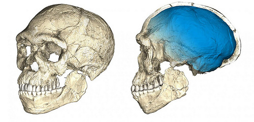
New fossil finds from the Jebel Irhoud archaeological site in Morocco have pushed back the origins of our species by 100,000 years, to at least 300,000 years ago, according to research conducted by Jean-Jacques Hublin of the Max Planck Institute for Evolutionary Anthropology in Leipzig, Germany, and Abdelouahed Ben-Ncer of the National Institute for Archaeology and Heritage (INSAP) in Rabat, Morocco. The new excavation uncovered 16 new Homo sapiens fossils along with stone tools and animal bones. The remains comprise skulls, teeth, and long bones of at least 5 individuals.. They also reveal what was on the menu for our oldest-known Homo sapiens ancestors 300,000 years ago.
Thermoluminescence dating of heated flints yielded an age of approximately 300,000 years ago—100,000 years earlier than the previously oldest Homo sapiens fossils.
Analysis of animal fossils found at the site provided additional evidence to support the date. Dating of rodent remains, for example, suggested they were 337,000 to 374,000 years old.
Pushing Back the Dates on Homo sapiens
Both genetic data of present day humans and fossil remains point to an African origin of our own species, Homo sapiens. Previously, the oldest securely dated Homo sapiens fossils were known from the site of Omo Kibish in Ethiopia, dated to 195 thousand years ago. At Herto, also in Ethiopia, a Homo sapiens fossil is dated to 160 thousand years ago. Until now, most researchers believed that all humans living today descended from a population that lived in East Africa around 200 thousand years ago. “We used to think that there was a cradle of mankind 200 thousand years ago in east Africa, but our new data reveal that Homo sapiensspread across the entire African continent around 300 thousand years ago. Long before the out-of-Africa dispersal of Homo sapiens, there was dispersal within Africa,” says palaeoanthropologist Jean-Jacques Hublin.
The Moroccan site of Jebel Irhoud has been well known since the 1960s for its human fossils and for its Middle Stone Age artefacts. However, the interpretation of the Irhoud hominins has long been complicated by persistent uncertainties surrounding their geological age. The new excavation project, which began in 2004, resulted in the discovery of new Homo sapiens fossils in situ, increasing their number from six to 22. These finds confirm the importance of Jebel Irhoud as the oldest and richest African Middle Stone Age hominin site documenting an early stage of our species. The fossil remains from Jebel Irhoud comprise skulls, teeth, and long bones of at least five individuals. To provide a precise chronology for these finds, researchers used the thermoluminescence dating method on heated flints found in the same deposits. These flints yielded an age of approximately 300 thousand years ago and, therefore, push back the origins of our species by one hundred thousand years.
“Well dated sites of this age are exceptionally rare in Africa, but we were fortunate that so many of the Jebel Irhoud flint artefacts had been heated in the past,” says geochronology expert Daniel Richter of the Max Planck Institute in Leipzig (Germany), now with Freiberg Instruments GmbH. Richter explains: “This allowed us to apply thermoluminescence dating methods on the flint artifacts and establish a consistent chronology for the new hominin fossils and the layers above them.” In addition, the team was able to recalculate a direct age of the Jebel Irhoud 3 mandible found in the 1960s. This mandible had been previously dated to 160 thousand years ago by a special electron spin resonance dating method. Using new measures of the radioactivity of the Jebel Irhoud sediments and as a result of methodological improvements in the method, this fossil’s newly calculated age is in agreement with the thermoluminescence ages and much older than previously realised. “We employed state of the art dating methods and adopted the most conservative approaches to accurately determine the age of Irhoud”, adds Richter.
The crania of modern humans living today are characterized by a combination of features that distinguish us from our fossil relatives and ancestors: a small and gracile face, and globular braincase. The fossils from Jebel Irhoud display a modern-looking face and teeth, and a large but more archaic-looking braincase. Hublin and his team used state-of-the-art micro computed tomographic scans and statistical shape analysis based on hundreds of 3D measurements to show that the facial shape of the Jebel Irhoud fossils is almost indistinguishable from that of modern humans living today. In contrast to their modern facial morphology, however, the Jebel Irhoud crania retain a rather elongated archaic shape of the braincase. “The inner shape of the braincase reflects the shape of the brain,” explains palaeoanthropologist Philipp Gunz from the Max Planck Institute for Evolutionary Anthropology in Leipzig. “Our findings suggest that modern human facial morphology was established early on in the history of our species, and that brain shape, and possibly brain function, evolved within the Homo sapiens lineage,” says Philipp Gunz. Recently, comparisons of ancient DNA extracted from Neanderthals and Denisovans to the DNA of present day humans revealed differences in genes affecting the brain and nervous system. Evolutionary shape changes of the braincase are therefore likely related to a series of genetic changes affecting brain connectivity, organization and development that distinguish Homo sapiensfrom our extinct ancestors and relatives.
The morphology and age of the fossils from Jebel Irhoud also corroborate the interpretation of an enigmatic partial cranium from Florisbad, South Africa, as an early representative of Homo sapiens. The earliest Homo sapiens fossils are found across the entire African continent: Jebel Irhoud, Morocco (300 thousand years), Florisbad, South Africa (260 thousand years), and Omo Kibish, Ethiopia (195 thousand years). This indicates a complex evolutionary history of our species, possibly involving the whole African continent.
“North Africa has long been neglected in the debates surrounding the origin of our species. The spectacular discoveries from Jebel Irhoud demonstrate the tight connections of the Maghreb with the rest of the African continent at the time of Homo sapiens‘ emergence”, says Abdelouahed Ben-Ncer.
Middle Stone Age Tools
The fossils were found in deposits containing animal bones showing evidence of having been hunted, with the most frequent species being gazelle. The stone tools associated with these fossils belong to the Middle Stone Age. The Jebel Irhoud artifacts show the use of Levallois prepared core techniques and pointed forms are the most common. Most stone tools were made from high quality flint imported into the site. Handaxes, a tool commonly found in older sites, are not present at Jebel Irhoud. Middle Stone Age artifact assemblages such as the one recovered from Jebel Irhoud are found across Africa at this time and likely speak to an adaptation that allowed Homo sapiens to disperse across the continent.
“The stone artifacts from Jebel Irhoud look very similar to ones from deposits of similar age in east Africa and in southern Africa” says Max Planck Institute archaeologist Shannon McPherron. “It is likely that the technological innovations of the Middle Stone Age in Africa are linked to the emergence of Homo sapiens.” The new findings from Jebel Irhoud elucidate the evolution of Homo sapiens, and show that our species evolved much earlier than previously thought. The dispersal of Homo sapiens across all of Africa around 300 thousand years is the result of changes in both biology and behaviour.
_______________________________________
These are two views of a composite reconstruction of the earliest known Homo sapiens fossils from Jebel Irhoud (Morocco) based on micro computed tomographic scans of multiple original fossils. Dated to 300 thousand years ago these early Homo sapiens already have a modern-looking face that falls within the variation of humans living today. However, the archaic-looking virtual imprint of the braincase (blue) indicates that brain shape, and possibly brain function, evolved within the Homo sapiens lineage. Credit: Philipp Gunz, MPI EVA Leipzig (License: CC-BY-SA 2.0)
_______________________________________
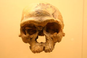
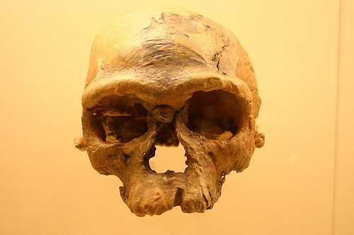
160,000-year-old Homo sapiens skull discovered at Jebel Irhoud. Ryan Somma, Wikimedia Commons
Findings from the site revealed more than the age of the human fossils, however. Plenty of gazelle meat, with the occasional wildebeest, zebra and other game and perhaps the seasonal ostrich egg, were among the finds that revealed the diet of these early ancestors, says Teresa Steele, a paleoanthropologist at the University of California, Davis, who analyzed animal fossils at Jebel Irhoud.
Steele, who studies how food sources and environmental change influenced human evolution and migration, was part of the international research team that began excavating at the site in 2004. She is the co-author of one of the two papers featured on the cover of the June 8 issue of Nature: “Human origins: Moroccan remains push back date for the emergence of Homo sapiens.”
Steele sifted through hundreds of fossil bones and shells found at the site, identifying 472 of them to species as well as recording cut marks and breaks indicating which ones had been food for humans.
Most of the animal bones came from gazelles. Among the other remains, Steele also identified hartebeests, wildebeests, zebras, buffalos, porcupines, hares, tortoises, freshwater molluscs, snakes and ostrich egg shells.
Small game was a small percentage of the remains. “It really seemed like people were fond of hunting,” she said.
Cuts and breaks on long bones indicate that humans broke them open, likely to eat the marrow, she said. Leopard, hyena and other predators’ fossils were among the finds, but Steele found little evidence that the nonhuman predators had gnawed on the gazelle and other prey.
Steele said the findings support the idea that the Middle Stone Age began just over 300,000 years ago, and that important changes in modern human biology and behaviour were taking place across most of Africa then.
“In my view, what it does is to continue to make it more feasible that North Africa had a role to play in the evolution of modern humans.”
Receive 30 days free access to the popular new CuriosityStream lineup of documentaries on science, history, nature, and technology as a new Popular Archaeology premium subscriber.
This richly illustrated issue includes the following stories: Recent findings shedding new light on the whereabouts of the remains of Philip of Macedon, father of Alexander the Great; how an archaeologist-sculptor is bringing bones of the dead back to life; archaeologists uncovering town life at the dawn of civilization; an exclusive interview with internationally acclaimed archaeologist James M. Adovasio about what makes the Meadowcroft Rockshelter prominent in the ongoing search for the first Americans; what archaeologists are finding at the site of the ancient city of Gath, the home town of the biblical Philistine giant, Goliath; and how scientists are redrawing the picture of human evolution in Europe. Find it on Amazon.com.
PHILADELPHIA, PA 2017—The Great Pyramids in Egypt, Stonehenge in England, and the Maya city of Teotihuacan were all built thousands of years ago. Add to that list of extraordinary achievements the earthen mounds—some rising to heights of 70 or 100 feet, some more than 5,000 years old—that dot the landscape of North America.
Moundbuilders: Ancient Architects of North America, a new exhibition opening June 24 at the Penn Museum in Philadelphia, tells the sometimes enigmatic story of more than 5,000 years of Native American moundbuilding through photographs, archival excavation records, and more than 60 artifacts excavated at mound sites throughout the eastern United States. The exhibition runs through December 2017.
About the Mounds
Earthen mounds—including some of the earliest monumental constructions in the world— have been engineered by diverse Native American groups over millennia. Yet the sizes, shapes, and purposes of mounds have varied greatly over time and geographical distance. Mounds have played and continue to play important roles in the religious, social, and political lives of Native American people. Some have been burial mounds; others have been centers of trade and community gatherings; still others have served as the foundations for important buildings or activities.
Archaeologists, fascinated by the extraordinary engineering feats of the moundbuilders, have been excavating and mapping this tradition since the 18th century. To date, many thousands of mounds have been discovered, from those at Cahokia, the massive Native American city outside Saint Louis, Missouri, to smaller mound sites like Smith Creek in Mississippi where the Penn Museum currently excavates. Over time, many mounds have been destroyed by farmers or leveled due to urban expansion; many more are believed to exist, not yet discovered.
A Chronological Approach
Moundbuilders explores the changing patterns of the construction and use of Native American mounds through time, beginning with the earliest known mounds, built by small groups of hunter-gatherers in the Lower Mississippi Valley as early as 3700 BCE. Without the help of metal tools, these early mound builders worked by hand moving basket loads of dirt. By 1400 BCE, the Poverty Point site in Louisiana was home to mounds that required thousands of laborers. In addition, exquisitely carved stone artifacts uncovered at the site suggest specialized artisans and an extensive trade network for materials.
Moundbuilding became much more common in later years. These constructions began to serve as burial places and certain burials were accompanied by elaborate grave goods. Some sites, like those associated with the Hopewell culture in Ohio (1 to 400 CE), included huge geometric enclosures that served as ceremonial centers for the surrounding populations. Around 600 CE, dramatic shifts in moundbuilding practices occured. In the Upper Mississippi Valley, people built thousands of effigy mounds in the shapes of animals. Further south, flat-topped platform mounds were built, serving as foundations for structures or stages for public activities.
Platform mounds were the most common mound form in the centuries leading up to European contact when corn agriculture developed and people congregated in major cities ruled by powerful chiefs. Though moundbuilding had largely ceased, some of these sites were still occupied when Europeans visited them in the 16th and 17thcenturies. A small renaissance of moundbuilding has begun today, as the Eastern Band of Cherokee Indians continues to construct the Kituwah mound in the mountains of North Carolina.
_______________________________________
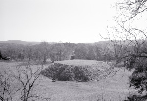
Mound B from atop Mound A (Great Temple Mound), Etowah Mounds, Near Cartersville,Georgiaca. 1250 CE. This black and white photograph by Tom Patton shows one of many large Mississippian period mound centers that dotted the landscape of eastern North America before European contact. Image courtesy Penn Museum
The exhibition includes excavated artifacts made from a variety of materials, including stone, such as the intricately carved underwater panther boatstone believed to be used as a weight on a spear thrower; ceramic, such as pots formed in the shape of human effigy figures; and shell, such as pendants from Key Marco, Florida. These latter objects bear sacred designs associated with the Southeastern Ceremonial Complex—a system of signs and symbols shared among different groups living hundreds of miles apart ca. 1000 – 1500 CE. In addition, visitors have an insider’s view into modern-day mound excavation through video footage of Dr. Kassabaum and her students excavating at Smith Creek in 2015. A case displaying hundreds of artifacts recovered on that expedition gives the visitor a sense of what most archaeological material looks like right after it is excavated.
________________________________________
Clay jar. 1200–1500 CE (Mississippian). Arkansas, Montgomery County. This ancient Mississippian Period ceramic jar, 17 cm tall by 18.5 cm wide, is from Arkansas. The style of decoration can help archaeologists determine when and where a pot was made, and the shape and size of the vessel can point to the types of activities taking place at the site. Image courtesy Penn Museum
Gorget (Ornament) Shell. 800–1400 CE (Late Woodland or Mississippian). Florida, Key Marco. The iconography on objects made of shell, bone, ceramic, stone, and copper speak to the belief systems of Mississippian people. The cross motif on this shell piece is thought to symbolize the center of the world and was part of a shared system of signs and symbols called the Southeastern Ceremonial Complex. 13 cm long by 12 cm wide. Courtesy Penn Museum
Photographing the North American mounds, often surrounded by lush greenery, farm fields, or nearby roadways, can be a challenge. For this exhibition, 38 photographs, the black and white work of two contemporary photographers—Jenny Ellerbe and Tom Patton—is featured. Their work captures the serene quality of these ancient sites while also illustrating how they are squeezed into today’s modern landscapes.
About the Curator
Dr. Megan Kassabaum, Weingarten Assistant Curator for North America at the Penn Museum and an archaeologist who directs the Smith Creek Archaeological Project, is curator of the exhibition. She has worked on mound sites throughout the eastern United States since 1999. Since 2005, she has worked in the Lower Mississippi Valley, exploring mounds constructed by the Coles Creek culture (700 to 1200 CE). As part of this fieldwork, she leads tours of many of the mound sites that are publically visible and has helped to develop a driving trail that allows visitors to explore sites that were built over the course of 5000 years along the Mississippi River.
“You don’t need a passport to visit extraordinary ancient monuments,” she noted. “I hope this exhibition will encourage more Americans to visit mound sites and gain a better understanding of the deep history of Native American peoples who’ve lived in North America for many thousands of years.”
The Penn Museum (the University of Pennsylvania Museum of Archaeology and Anthropology) is dedicated to the study and understanding of human history and diversity. Founded in 1887, the Museum has sent more than 300 archaeological and anthropological expeditions to all the inhabited continents of the world. With an active exhibition schedule and educational programming for children and adults, the Museum offers the public an opportunity to share in the ongoing discovery of humankind’s collective heritage.
The Penn Museum is located at 3260 South Street, Philadelphia, PA 19104 (on Penn’s campus, across from Franklin Field). Public transportation to the Museum is available via SEPTA’s Regional Rail Line at University City Station; the Market-Frankford Subway Line at 34th Street Station; trolley routes 11, 13, 34, and 36; and bus routes 21, 30, 40, and 42. Museum hours are Tuesday through Sunday, 10:00 am to 5:00 pm, and first Wednesdays of each month until 8:00 pm, with P.M. @ PENN MUSEUM evening programs offered Wednesdays, June 28 through September 6. Closed Mondays and holidays. Admission donation is $15 for adults; $13 for senior citizens (65 and above); free for U.S. Military; $10 for children and full-time students with ID; free to Members, PennCard holders, and children 5 and younger. July and August: special admission donation is $10 for adults, seniors, children (6 to 17) and full time students with ID.
Hot and cold meals and light refreshments are offered to visitors with or without Museum admission in The Pepper Mill Café; the Museum Shop offers a wide selection of gifts, books, games, clothing and jewelry. Penn Museum can be found on the web at www.penn.museum. For general information call 215.898.4000. For group tour information call 215.746.8183.
This richly illustrated issue includes the following stories: Recent findings shedding new light on the whereabouts of the remains of Philip of Macedon, father of Alexander the Great; how an archaeologist-sculptor is bringing bones of the dead back to life; archaeologists uncovering town life at the dawn of civilization; an exclusive interview with internationally acclaimed archaeologist James M. Adovasio about what makes the Meadowcroft Rockshelter prominent in the ongoing search for the first Americans; what archaeologists are finding at the site of the ancient city of Gath, the home town of the biblical Philistine giant, Goliath; and how scientists are redrawing the picture of human evolution in Europe. Find it on Amazon.com.
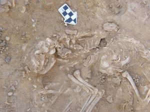
SMITHSONIAN TROPICAL RESEARCH INSTITUTE—A new report* by Smithsonian archaeologists and colleagues in the International Journal of Paleopathology identifies a bone tumor in the upper right arm of an adolescent who was buried in about 1300 AD in a trash heap at a site in western Panama called Cerro Brujo or Witch Hill. The reason for what appears to be a ritual burial in this abandoned pre-Colombian settlement is unknown.
“Based on the analysis of a tooth from the individual, we think he or she was buried about 150 years after the settlement was abandoned,” said Nicole Smith-Guzmán, post-doctoral fellow in staff scientist Richard Cooke’s lab at the Smithsonian Tropical Research Institute (STRI) in Panama. “And based on the fact that the body was tightly wrapped in the fetal position and buried face down with two clay pots and a shell trumpet like those still used by indigenous Ngäbe people in this area today, we consider this a ritual burial.”
STRI archaeologist Olga Linares (1936-2014) and Anthony Ranere, professor emeritus at Temple University, discovered the burial in 1970, during a study funded by the U.S. National Science Foundation.
Linares proposed that the first inhabitants of Cerro Brujo were farmers who had fled to the site, about 3 kilometers from the Caribbean coast, from the nearby Chiriquí highlands when Volcán Barú erupted in approximately 600 AD. Linares and Ranere found evidence that the site was inhabited twice, once from about 600 AD and a second time between 780 and 1252 AD.
The burial in question, in the largest of five ancient trash pits at the site, may have been placed there because it was the site where the individual’s ancestors lived. A large town site nearby, Sitio Drago near Boca del Drago on Isla Colón, excavated by UCLA archaeologist Tom Wake was occupied from roughly 600 AD until 1410 AD.
Smith-Guzmán is a bioarchaeologist who analyzes ancient bones to look for signs of health problems. In looking at the remains from the site 46 years later, she was surprised to find evidence of cancer in the upper right arm of an individual who was probably 14-16 years old.
She took the bones to the Centro Radiológico Metropolitano in Panama City and also to the radiology department at Punta Pacífica Hospital.
“As far as we know, this is the first case of cancer in ancient human remains reported from Central America,” Smith-Guzmán said. “Both osteosarcoma and Ewing sarcoma, the two most likely cancers in this case, are most common in children and adolescents. Most of the published cases of these cancers in the past were from adults–probably due to the poor preservation of non-adult skeletal remains–making this find especially rare.”
_____________________________________
Nicole Smith-Guzmán, post-doctoral fellow who discovered the first-known case of cancer in an ancient skeleton from Central America, working in staff scientist Richard Cooke’s lab at the Smithsonian Tropical Research Institute in Panama. Credit: Sean Mattson, STRI
This is a computed tomography (CT scan) of the right humerus. Left image shows a horizontal slice through the cancerous lesion. Credit: Nicole Smith-Guzmán
Most of the other examples of bone cancers are from places in the world with much more extensive collections of archaeological material. This form of cancer typically leaves a very characteristic “sunburst” pattern in the bone. The bones also show evidence of anemia that may have been a result of the cancer or of another inflammatory or metabolic disease. Three dimensional models of the humerus, one from a CT scan and the other from photogrammetry, are available in a program called Sketch Fab and in the supplementary material included in the article for use by other archaeologists and health professionals.
Shell trumpets like the one at the site made from an Atlantic triton shell (Charonia variegata) are used in the balsería ritual practiced by Ngäbe peoples in this region of Panama. The Ngäbe believe that a disruption of the balance between the natural and supernatural worlds can lead to sickness when a malevolent spirit enters the body during a dream to steal the soul. Traditionally, when a person was sick, a Ngäbe shaman, called a Sukia, would attempt to heal a patient using herbal remedies such as Hoffmannia longipetiolata, a plant still used in Ngäbe communities as an analgesic.
Smith-Guzmán will use DNA analysis, in collaboration with geneticists at the University of Göttingen, to learn more about the ancestry of the individual and the type of cancer s/he suffered from.
This richly illustrated issue includes the following stories: Recent findings shedding new light on the whereabouts of the remains of Philip of Macedon, father of Alexander the Great; how an archaeologist-sculptor is bringing bones of the dead back to life; archaeologists uncovering town life at the dawn of civilization; an exclusive interview with internationally acclaimed archaeologist James M. Adovasio about what makes the Meadowcroft Rockshelter prominent in the ongoing search for the first Americans; what archaeologists are finding at the site of the ancient city of Gath, the home town of the biblical Philistine giant, Goliath; and how scientists are redrawing the picture of human evolution in Europe. Find it on Amazon.com.
UNIVERSITY OF THE WITWATERSRAND—In a study published in the international journal Antiquity, Professor David Pearce, Director of the Rock Art Research Institute at the University of the Witwatersrand, Johannesburg, Adelphine Bonneau of Laval University, and colleagues at the University of Oxford showed that paintings in south-eastern Botswana are at least 5,500 years old, whilst paintings in Lesotho and the Eastern Cape Drakensberg, South Africa, date as far back as 3,000 years. These dates open the floodgates for researchers to ask and answer questions about the rock art that have baffled them for decades.
The dates obtained show some surprising results. In some sites, paintings continued to be made for more than a thousand years. “This is astonishing,” says Pearce, “people returned to the same rock shelters over very long periods of time to make rock paintings very similar to those made centuries or millennia before. This finding has profound implications for our understanding of hunter-gatherer religion in southern Africa.”
Research was conducted in the Thune Dam in Botswana, the Metolong Dam area in the Phuthiatsana Valley of Lesotho, and the Drakensberg Escarpment of the Eastern Cape in the ‘Nomansland’ region of South Africa. A total of 43 new dates were produced from these three areas, including the first direct dates on rock paintings ever in Botswana and Lesotho.
The new dates were obtained using radiocarbon dating. Over the decades rock art has proved extremely difficult to directly date. Indeed, it has been a major obstacle in this area of research. The success of this project is based on very careful chemical characterisation of the composition of the paint and contaminants on the rock. New chemical techniques were developed to remove contaminants from small samples of paint. These could then be dated using accelerator mass spectrometry (AMS) radiocarbon dating.
The two-phase research project entailed collecting tiny (less than a millimetre squared) quantities of pigment from the rock painting and then analysing these samples to determine which art should be sampled for AMS radiocarbon dating. The samples that contained the most carbon-black (and thus most likely to reveal dates) were then radiocarbon dated.
The dates reported in this study form the biggest set of direct dates on rock art in South Africa and the only direct dates ever obtained in Botswana and Lesotho.
Lead author, Bonneau, concludes in the paper: “This protocol is a step forward in the field of rock art dating by reducing the sample size to be collected, by optimising the success rate of such dating, and by limiting the impact on such valuable paintings while providing new chronological insights.”
This richly illustrated issue includes the following stories: Recent findings shedding new light on the whereabouts of the remains of Philip of Macedon, father of Alexander the Great; how an archaeologist-sculptor is bringing bones of the dead back to life; archaeologists uncovering town life at the dawn of civilization; an exclusive interview with internationally acclaimed archaeologist James M. Adovasio about what makes the Meadowcroft Rockshelter prominent in the ongoing search for the first Americans; what archaeologists are finding at the site of the ancient city of Gath, the home town of the biblical Philistine giant, Goliath; and how scientists are redrawing the picture of human evolution in Europe. Find it on Amazon.com.
More than four decades ago, archaeologists uncovered the skeletal remains of three individuals within a tomb located near the small town of Vergina in Macedonia, Greece. The bones, which were found scattered along the floor of what is described to be a comparatively modest tomb associated with the Great Tumulus, the resting place of some of the Kingdom of Macedonia’s most iconic early royal families, were identified to be those of an adult male in his 40’s, a young adult female, and a newborn infant. Arguably the most intriguing skeletal remains were those of the adult male, however — and more particularly two bones — a left femur and a left tibia, both of which showed signs of having fused together over time after an apparent severe wound to the knee caused by a sharp instrument, such as a spear.
These characteristics, along with a host of other circumstantial findings within the tomb, along with historical accounts, seemed to point, according to scientists who recently studied the bones and the tomb, to a tantalizing conclusion — that the bones, and the true resting place of King Philip II of Macedon, father of Alexander the Great, had been found. But not all scholars are on board with the conclusions. Debate continues, and further studies surely follow.
___________________________________
Left leg showing the massive knee ankylosis (fusion of the joint). Image courtesy of Javier Trueba
This richly illustrated issue includes the following stories: Recent findings shedding new light on the whereabouts of the remains of Philip of Macedon, father of Alexander the Great; how an archaeologist-sculptor is bringing bones of the dead back to life; archaeologists uncovering town life at the dawn of civilization; an exclusive interview with internationally acclaimed archaeologist James M. Adovasio about what makes the Meadowcroft Rockshelter prominent in the ongoing search for the first Americans; what archaeologists are finding at the site of the ancient city of Gath, the home town of the biblical Philistine giant, Goliath; and how scientists are redrawing the picture of human evolution in Europe. Find it on Amazon.com.
It would not be inaccurate to say that most archaeologists spend much of their lives within the narrow parameters defined by chosen areas of specialization. Some have even spent most of their entire careers focusing on a single archaeological site and what the site says about its particular corner of history and culture. Put together, the sum of these efforts and experiences across the world can paint a fascinating mosaic of our past, while raising a barrage of new questions at the same time.
At times some archaeologists, however, have chosen to deal with the broad brush of archaeological inquiry. For a variety of reasons, they elect to stand back and view the entire panorama of discovery and research, whether it is for the purpose of writing a book or teaching a class.
A few may even travel the world to do this.
Kate Leonard, an adventurous Canadian archaeologist, did just that. Beginning in January, 2016, she embarked on a global journey to twelve different destinations in 12 months to explore and reveal a taste of the vast variety of digs and research going on across the globe. Calling it the “Year of Digs”, or Global Archaeology Year, she created a website and blog to document and publicize her journey, bringing the world of archaeology across the world, as she hopped from one destination to another, to the smartphones, tablets and laptops of thousands of readers, young and old. Popular Archaeology also followed her on that journey with a series of articles.
Here is a final interview of Kate, capping what for her and many of her readers was a truly unique learning experience in the world of archaeology, beginning with her first stop in New Zealand and ending in Switzerland:
Questions: What unique or interesting experiences did you encounter or acquire (people, places, events) that you think are worth noting; what is the significance and impact (potential or real) of the work being done; and, what have you learned from this that you did not know or experience before?
New Zealand
On my first stop, I excavated Maori horticultural sites that likely date to before the arrival of Europeans in New Zealand. The types of features we were encountering were: kumara storage pits and structures, borrow pits (large pits dug by the Maori to remove sand beneath the natural subsoil to help them mix and cultivate their soils for horticulture), fire pits and post-holes. The two sites I worked on were located in the Bay of Plenty region and in the Waikato region of the North Island. My tasks were to excavate and record archaeological features in advance of infrastructural development. This involved investigating features to see if they were archaeological, excavating half of the feature if it was archaeological and then recording it through photographs, soil samples, plans and context sheets. Another major component of the excavations was working closely with iwi monitors to ensure an atmosphere of mutual understanding and respect.
In New Zealand all archaeological excavations are monitored by a member of the local iwi. In the Bay of Plenty region the iwi monitor was an elder of that community and was there to observe and comment. In the Waikato the iwi decided to have four members involved on a rotating basis and interact directly with the archaeologists to learn about the process of doing archaeology and what we were finding on the site. This was a very exciting and enriching experience for me because I learned more about the archaeology I was excavating through explaining the methodology behind it and hearing about the cultural practices that the archaeology reflects. I was also able to discuss the current political and cultural situation of the Maori people and how this has changed over the past 20 years (for the better). When you are working with another person in close proximity, for instance excavating a small archaeological feature together, it is easy to allow the conversation to flow and not feel forced like it could in a formal situation like an interview.
In the case of the Bay of Plenty, this is the first time that archaeology has been recorded on that ridgeline, even though it is a residential area full of houses. For the local iwi the discovery of so much archaeology on that small strip of land confirms what their oral history already says. They now know the physical evidence of Maori occupation of that location. In the Waikato the impact is different but no less significant. By exposing members of the local iwi to the basics of archaeology the mystery surrounding what archaeologists are doing is removed. Since archaeologists have to work closely with the iwi when they are developing excavation plans this helps both sides to understand what is required and why. It also adds an additional dimension to the Maori understanding of their past and how daily activities like horticulture were practiced hundreds of years ago.
I was not prepared for the sheer scale of some of the archaeological features we would be excavating. In the Waikato some of the borrow pits were 8m by 4m and over 2m deep. I had also not understood the level of complexity behind Maori horticultural practices and how much they had to augment the soils of New Zealand in order to grow the crops they brought with them from Polynesia. These practices were labor intensive and would have required an in-depth knowledge of their crops and how to manufacture soils to suit them.
Image: Waikato borrow pit under excavation. Courtesy Kate Leonard
Australia
Willow Court is a large complex of buildings that functioned as a mental health institution from 1827 to 2000. It was originally named the New Norfolk Insane Asylum and was built to care for convicts transported to Tasmania by the British Government (then known as Van Diemens Land). I joined the archaeological team and field school being run at Willow Court by Dr. Heather Burke of Flinder’s University. The field school focused mainly on the exercise yard outside of Ward C, the original Barracks building and the contemporary Superintendents cottage, Frescati House.
The main goal for the field school was to lay the groundwork for the excavations due to take place the next season. Specifically, mapping the institutional complex with a total station, doing geophysical surveys to identify sub-soil features and cataloguing artifacts in storage. One objective was to discern what artifacts and materials were retained since 1960, the processes involved in that retention, and what has been lost since. A complete archaeological recording of Frescati House was also in order to help the team and interest groups understand the construction pattern of the house as well as to record it. There was no good spatial data of the Willow Court complex or Frescati House so creating a comprehensive digital plan of the exterior areas (where future excavations may take place) was very important. The three types of geophysical equipment used were ground penetrating radar, an electrical resistivity device and a magnetic gradiometer. It is hoped that the results of the geophys will help the team to target areas to excavate next season.
As you can imagine the local community of New Norfolk has to grapple with stigmatization due to the legacy of this type of institution operating for 170 years. The future of the Willow Court institutional complex is therefore a sensitive and contested issue. On a positive note, the archaeological investigations being conducted here should help all the stakeholders to understand the current state of the site and the artifacts associated with it. With that information hopefully a productive solution that suits all parties can be developed. There have been arguments since the 1960’s about turning the site into a museum or at least preserving it, however nothing has ever developed. As a result the site has fallen into disrepair and is a favorite spot for local teenagers to vandalize. Without cataloguing the known material no plan can be developed to move forward with the future of Willow Court, so it was of the utmost importance that each object be catalogued and documented properly.
Although I was aware of Australia’s Convict Era and had some general knowledge of the severity of the penal system in place, the mental health repercussions had never crossed my mind. The journey in convict ships, physical punishment and mental punishment (such as solitary and silent confinement of prisoners in places like Port Arthur and Cascades Female Factory), and forced hard labor tested the limits of all the convicts minds and some were irreparably damaged by their experiences. Willow Court remained an important institution long after the Convict Era and that should serve to remind us that mental health affects all human populations in all time periods.
Image: The barracked bulding of Williow Court as it appears today. Courtesy K. Leonard
Fiji
The Archaeological Department of the Fiji Museum conducts Archaeological Impact Assessments (AIA’s) prior to the commencement of development projects (like the building of a resort) and in response to community requests. Communities often request AIA’s to be conducted on cultural significant sites that they perceive to be under threat (for instance by resort expansion) and that they would like to be protected by the government. Due to Cyclone Winston the fieldwork we conducted was directly associated with post-cyclone damage assessment. We traveled west from Suva to Nadi doing Archaeological Impact Assessments for communities and developers. We also conducted some post-cyclone assessments for national heritage sites like the Sigatoka Sand Dunes (where we had to do an unanticipated rescue lift of two human skeletons) and some WWII sites in Suva, and for a community administered site, the Tavuni Hill Fort. I was exposed to the full spectrum of Fijian archaeology in terms of both chronology and site type including Bourewa, site of the earliest known settlement in Fiji (c. 3100BP) and Momi Battery, a WWII gun emplacement site run by the National Trust of Fiji.
The physical challenges to doing fieldwork in Fiji are the heat, humidity and mosquitoes. Dengue fever is also a concern, especially after a violent storm like a cyclone that leaves a lot of standing water. The pace of work is also very different from what I am accustomed to as a North American. There are certain protocols and sequences of interaction that must be followed in order to be considered polite. Essentially this entails discussions and gifting that lead up to the actual fieldwork, time during which most ‘westerners’ would be ‘chomping at the bit’ to get started. However, this aspect is very important to Fijians and it is considered disrespectful to do otherwise. When archaeologists go out into the field to conduct work they must first visit the village associated with the land/archaeological site they are interested in, and then participate in a sevusevu. This is a ceremony whereby kava (a mildly narcotic powdered root made into a drink) is exchanged and consumed. The ceremony not only allows for the exchange of information regarding where all the parties are from, their chiefly affiliations and what work they wish to conduct, but it is a way of showing respect. It is a great transgression to go onto a community’s land without conducting the sevusevu.
The cultural heritage resource sector in Fiji is incredibly underdeveloped. The tourism sector has in the past focused on resorts and spas. However, there is now a move towards a new kind of tourist experience that includes village visits, home-stays, and natural/cultural experiences. It is essential for community groups that, if development along these lines takes place, their cultural sites are not negatively impacted. The work of the Archaeology Department of the Fiji Museum is crucial to the success of these processes. As they are a neutral institution they advise what is in the best interest of the archaeology, acting as best they can to ensure that the cultural heritage of Fiji remains accessible and available for all Fijians.
I had not anticipated the diversity of archaeological sites in Fiji. The archaeological collections held in storage by the Fiji Museum are impressive even though there have not been many archaeological investigations and there is still so much to discover and discuss. I was struck by how traditions and customs have remained important aspects of Fijian daily life, long after British colonization and the upheaval of WWII which brought many modernizations, especially in terms of infrastructural development. This has ensured that the culture remains vibrant. The country is very poor but the people have an infectious positive attitude. This was especially apparent in the aftermath of Cyclone Winston. Homes and livelihoods had been destroyed but people were focused on rebuilding and considered themselves blessed that so few people had been hurt. Such a positive outlook on life is inspirational.
Image: Fragments of ceramic salt drying trays. Image courtesy Kate Leonard and the Fiji Museum
Mexico
My experience in Mexico took place in the small village of Tahcabo, in the center of the Yucatán Peninsula in Mexico. I worked with the Collaborative Archaeological Project of Eastern Yucatán (PACOY: Proyecto Arqueológico Colaborativo del Oriente de Yucatán). The principal investigators of the project were Dr. Patricia A. McAnany (UNC, InHerit) and Dr. Iván Batún Alpuche (UNO, AGEY). The excavation I participated on was under the direction of Field Coordinator Maia Dedrick, who is conducting primary research for her doctoral dissertation. In the this field season the team was excavating rejolladas and abandoned settlements in order to better understand changes in Maya horticultural practices that took place when the Spaniards first came to the area around Tahcabo. Rejolladas are natural solution sinkholes in the karstic limestone that collect rich soils ideal for cultivation. The rejolladas located in the village of Tahcabo itself are still actively used for gardening, for making earth ovens (píib) and for conducting the Ch’a’ Cháak rain ceremony. There are usually chickens wandering through and there could be vegetables growing, tree crops, animals, or some other activity taking place. As part of her dissertation research, Field Coordinator Dedrick is examining changes in how food was grown in Tahcabo’s rejolladas from the Classic period through the Spanish colonization of Mexico (ca. 600-1800 CE). It is hoped that these investigations will shed more light on how sweeping social changes affected community organization, agricultural production, and food preparation. To achieve this, the excavation provides samples for analysis of macro- and micro-botanical remains and soil chemistry.
Dedrick excavated 2m x 2m trenches in six of Tahcabo’s rejolladas. From pre-determined depths within the trenches the team systematically took archaeo-botanical samples such as charcoal for C14 dating, 30 liters of soil for flotation, around 30 grams of soil for both carbon isotope analysis and pollen analysis, and about 100 grams of soil for phytolith and starch grain analysis. Since each 20cm depth is being sampled in so many ways Maia will have many pieces of evidence to figure out the puzzle of ancient Maya gardening in Tahcabo’s rejolladas. By collecting C14 samples for each layer it will be possible to find out if the types of plants grown changed over time. It’s possible that the results will show how gardening practices in Tahcabo changed after the arrival of the Spaniards to Mexico.
A very important component of the Project is community involvement. The excavation sites are located within the municipal boundaries and the residents of Tahcabo are actively encouraged to participate in all aspects of the project. We often had visitors to the rejolladas we were excavating in and were of course working alongside people from the local community. The excavations were a good opportunity for a few months of consistent paid work and the knowledge of the local area that they brought to the project was highly valued. Students from the Universidad de Oriente (UNO) and Universidad Autonoma de Yucatán (UADY) are also active members of the project, an initiative that provides an opportunity for the younger generation, including those who themselves speak Maya, to study local Maya culture, anthropology and archaeology. Wider dissemination will come in the form of educational materials and reports (in Spanish and Yucatec Maya) composed by Dedrick in collaboration with the non-profit group InHerit.
Image: Planning limestone at the end of an ancient settlement mound. Photo by M. Dedrick of PACOY
South Africa
My next stop was in South Africa, at a series of cave shelters at Pinnacle Point on the southern coast. The first cave to be excavated, PP13B, has given us the earliest evidence for human consumption of shellfish – dated to around 164 000 years ago. Cave PP13B also contained evidence for early use of ochre pigment and heat treatment of stone artifacts. PP5-6 has provided the earliest known evidence for the knapping of microliths to make composite tools (possibly the earliest evidence for projectile points around 71 000 years ago), and to make those microliths they focused on heat treatment to improve the stone. Today a large interdisciplinary team is working together at the rockshelter PP5-6 to provide a fuller context within which to understand how early humans were living in this area many tens of thousands of years ago. The archaeological material being excavated at Pinnacle Point is providing information about the evolution of modern humans and therefore its importance goes beyond that of a single country or cultural group – this is how our shared human story began. The types of innovations that have been revealed by the excavations in the cave shelter complex share some major traits: cooperation, organization and planning. For example, the archaeological evidence of shellfish collecting implies a knowledge/awareness of lunar cycle as this activity can only be done at low spring tide (a new and full moon). Once this knowledge began to be implemented to harvest shellfish the people living at Pinnacle Point had a predictable source of calorie rich protein with which to supplement their diet.
PP5-6 contains archaeological material that dates from between 90 – 50 000 years ago. There is one long section through the entire cave shelter that connects all the stratigraphic layers from the earliest to the latest. The stratigraphy at the base of the ‘long section’ is so deep that it has been completely buttressed with sandbags. I had never excavated such ancient archaeology before and I was keenly aware of this. At Pinnacle Point the level of detail being recorded was truly astounding. A really exciting innovative technique developed by the Pinnacle Point team is the use of barcode scanners to record all artifacts, samples, sieved buckets and archaeological features (lot numbers, stratigraphic units, contexts, etc.). The barcode scanners are directly connected to a handheld computer that is connected to a total station (a high tech piece of survey equipment that makes digital 3D maps). Each time an artifact is found its coordinate in 3D space is plotted with the total station and this information is stored in that total station’s tablet. A barcode is then scanned and placed in a bag with the artifact. Each artifact gets its own individual barcode. Since the archaeological feature that artifact came from also has a barcode (previously scanned into the system) when the artifacts are analyzed and catalogued back at the lab the barcode is simply scanned again to access all data associated with that artifact and the location it came from in the excavation. There are two recorders on site and each is responsible for all the forms and logs for half the excavation. The excavators and recorders work together to ensure that all information logged is correct: the sediment excavated (its color, texture, moisture level and composition), the artifacts uncovered (types, amount, orientation and distribution), samples collected, photographs taken, and much more. Tablets are great pieces of tech for doing this type of work! They are lightweight and mobile so can easily be carried around an archaeological site from excavator to excavator. A really nice feature is the ability to take a photo with the tablet, draw on the photo and make notes related to what was excavated and what still needs to be excavated, then upload it directly onto the stratigraphic unit form on the tablet. It is amazing to see the activity on site with excavators furiously digging, the site recorders moving between their workstation and the excavators, and 5 total stations being run simultaneously to keep up with the amount of archaeology being revealed.
In the end, the excavations at Pinnacle Point are teaching us about the complex lives of our earliest human ancestors. It is possible that the individuals that created the archaeological remains being unearthed are the ancestors of those humans who went on to populate the globe.
Image: The team working at the lower end of the excavation in PP 5-6. Courtesy Kate Leonard
Greece
In Greece, I worked with the Stélida Naxos Archaeological Project (SNAP), an international team led by Dr. Tristan Carter of McMaster University through the Canadian Institute in Greece, along with his co-director Dr. Demetris Athanasoulis of the Cycladic Ephorate of Antiquities of the Hellenic Republic’s Ministry of Culture and Sports. This team is investigating the hilly peninsula of Stélida on the island’s western coast, home to the earliest known archaeological site in the region. The hill itself is basically one big chert source where people came to get raw material for making stone tools since the Lower Palaeolithic (at least 250,000 years ago) and through to the Mesolithic (to 9,000 years ago). What is being found in the excavations are the leftovers from thousands of years of removing chert from the outcrops and the roughing out of stone tools. This isn’t necessarily where hominins and, later on, humans lived — instead, the archaeological material being uncovered indicates that Stélida was a place returned to again and again to extract chert from which to make sharp and durable tools. At Stélida there is known Middle Palaeolithic activity identified from diagnostic prepared core technology, demonstrating that some of the anthropogenic material found here can be securely dated to the time when Neanderthals were living in Europe. It is also possible that there were other hominid species taking away and using Stélida chert even earlier, suggested by the tantalizing evidence for Lower Palaeolithic activity in the form of possible bifaces that could be interpreted as handaxes; these large heavy tools could have been made by Homo heidelbergensis, the predecessor of the Neanderthals in Europe. The possibility for evidence of these early hominids living on what are now the Cycladic islands has not been seriously investigated before and if conclusively verified will change how we understand the movements of hominids across the globe.
A very early site that was primarily used as a raw material source doesn’t necessarily contain all the lovely (easily identified) stone tools that would be found on a habitation site — instead, you find the leftovers from making these stone tools. There is so much lithic material being found at Stélida that the team struggles to wash it so the lithic specialist can assess it and inform the team of diagnostic pieces uncovered. I was tasked with excavating a 2m x 2m trench about ¾ of the way up the hill that was positioned immediately at the base of a substantial chert outcrop. Until I had excavated about a meter below the modern ground surface half of the soil was full of stone tool making leftovers (debitage) and identifying the lithic material was initially a challenge for me.
Not only is Stélida a stunningly beautiful location to dig, but there is the possibility that my contribution to the project will help us better understand how hominids and humans spread across the globe. It was exciting to be part of a project that is asking difficult questions and trying to reassess how we are interpreting the archaeological record. The debris left behind as raw material was selected and worked from the same locations over thousands and thousands of years. This can inform archaeologists about the different behaviors and skills of these hominids. This exciting groundbreaking research is investigating a previously overlooked region of Greece for possible alternative routeways for Homo sapiens and their ancient predecessors’ movements from Africa into Europe and Asia.
Image: A view of the trench where Kate was excavating. Courtesy Kate Leonard
Ireland
The next stop was Ireland, with the Caherconnell Archaeology Field School (CAFS), directed by Dr. Michelle Comber. Caherconnell Cashel is a possible indigenous royal settlement occupied from the 10th century to the 15th/16th centuries AD. The ‘cashel’ is a drystone (no mortar) enclosure: a 4m-high limestone wall enclosing a circular area that contained dwellings, the enclosure having an east-facing entrance. Already the excavations in the interior of the cashel have revealed evidence for a series of occupation/building phases that indicate a long period of use. Many medieval artifacts have been uncovered, such as clothes-fastening pins (aka dress pins) of various styles, glass and amber beads, iron knives and shears, and intricately carved bone hair combs. Stone walls, animal bone and finely worked metal objects all come together to tell the story of the medieval ‘native’ Irish Gaelic people who lived and worked at Caherconnell –- a story not fully told through written history. The seasonal digs at Caherconnell are helping archaeologists and historians to better understand the lifestyle of Gaelic Irish people in the medieval period, a period whose narrative is often dominated by the archaeology, architecture and politics of the invading Anglo-Normans (from the 12th century AD). It is very important that the story of the native population be put back into the narrative of medieval Ireland. Understanding the daily lives of Caherconnell’s medieval occupants can help to fill-out this narrative and the underlying limestone bedrock of the region creates an alkaline condition (non-acidic) that preserves bone wonderfully, thus allowing for a fuller understanding of the average diet. The large animal bone assemblage from the site indicates that the cashel’s occupants throughout the medieval period had a rich varied diet including pig, sheep/goat and cow milk products and meat, fish, shellfish, and poultry which also means eggs. The meat in their diet was supplemented with gathered herbs, fruits and nuts (like the ever present hazelnut!), and cereal grains like barley, oats, rye and wheat ground by hand into flour and/or meal using heavy stone rotary querns.
Since I worked with Dr. Comber on a nearby project (for three seasons) in the past I was asked to help supervise the students on-site. Most of the students had never excavated before and it is great fun to dig beside them and experience the joys and disappointments of being a rookie ‘digger’ as they did. The bedrock is very close to the topsoil (in some cases only 10cm but in others can be up to a meter in depth) in the Burren and so a large area can be excavated down to the natural level in a short period of time. I was digging in an area of the site where the foundations of a round structure, and associated internal features, were revealed that likely date to the earliest occupation of the cashel – the 10th century AD. This structure appears to have been some sort of kitchen/workshop area.
The stone fort itself is open to the public through the Visitor Center (which has a wonderful cafe!). This working farm and tourist destination is run by Mr. John Davoren, the landowner, and is a shining example of an archaeological site integrated into a sustainable family business.
Image: Field school team members excavating at the site of the Caherconnell Cashel. Courtesy Kate Leonard
Portugal
In Portugal, I participated in an excavation led by site directors Miguel Serra and Eduardo Porfirio and supervisor Sofia Eiras. They investigated the Late Bronze Age (1250-850 BC) fortified hilltop settlement of Outeiro do Circo in the Alentejo plain of southern Portugal. The site covers about 17 hectares. This huge area was enclosed by a complex defensive system: a double wall of stone, fire hardened clay and wood was augmented with bastions, ramps, platforms and an exterior retaining wall built on a disused ditch. By its size alone it is clear that Outeiro do Circo was an important location in the region and this season the team was investigating the interior area. The team opened a number of trenches on the summit of the hilltop and just inside the enclosing wall. Their goal was to gain a better understanding of what went on inside the wall during the Late Bronze Age and to assess the level of disturbance to the archaeology from modern farming. Outeiro do Circo is one of the largest settlements of this time period in the Iberian Peninsula. It is also situated in an area which has (relatively recently) undergone significant archaeological investigation due to infrastructure development. Because of this development it is now known that the large fortified Outeiro do Circo settlement was not isolated in the Late Bronze Age but was in fact located in a landscape dotted with small contemporary settlements – a perspective which drastically changed archaeological understanding of this regions Bronze Age.
I was tasked with digging a trench on the northwestern slope of the hill within the line of the wall. Within the trench some exciting evidence of Bronze Age activity was found – including a cup-marked stone and various types of diagnostic pottery. One morning when I arrived on site the sunrise was slanting across the site and I noticed some indentations on one of the larger stones in the trench. As I excavated this stone it became clear that it was decorated with prehistoric cup-marks, intentionally created by one or more people and then positioned in the Late Bronze Age structural feature we were revealing. Cup-marked stones, or in Portuguese “rochas com covinhas” – or just “covinhas” for short -are a type of prehistoric decorated stone found across western Europe. They are difficult to date but are certainly prehistoric – Neolithic, Copper Age and/or Early Bronze Age – and have frequently been found reused on later prehistoric sites, as is the case at Outeiro do Circo. The cup-marked stone from my trench is the fourth found at Outeiro do Circo. One was found at the base of a deep Late Bronze Age pit close to the summit of the hilltop and another was used in the construction of the top course of the enclosing wall. The fourth is a large boulder that sits in situ where it was decorated. This has by far the most cup-marks on it and is located in a part of the hill that would have been ideal for settlement. This stone must have been known about in the Late Bronze Age when the hill was being fortified. The cup-marked stones found at Outeiro do Circo were not reused in a context that could be interpreted as particularly special or religious, but still….the three smaller stones were integrated into the construction of features on the hilltop. It is particularly intriguing to me that here there are both smaller cup-marked stones that were moved from their original position to be reused and the large boulder that still sits where it was decorated.
Fragments of pottery from the Chalcolithic to the Roman period have been found on the ground surface at Outeiro do Circo but by far the most common are those from the Late Bronze Age. The archaeological investigations being conducted by the team here are helping to paint a vivid picture of it as an important Late Bronze Age settlement in what seems to have been a thriving region.
The Projecto Outeiro do Circo is highly engaged with the local community. They frequently post their findings on the project blog (http://outeirodocirco.blogspot.pt) and have regular evening talks about the project or topics related to it. The project also organizes site visits and workshops for children’s groups (and adults) over the summer. An even bigger initiative is the “12 Lugares, 12 Meses, 12 Histórias”, which involves the eleven regions around the central town of Beja showcasing their Bronze Age sites through walks and talks. This initiative was organized after I contacted the site director, Miguel Serra, about volunteering with them for month 8 of my 12 countries – 12 projects – 12 months Global Archaeology year.
Image: The cup-marked stone emerging from the trench. Photo courtesy Kate Leonard
Scotland
In Scotland, the Heritage and Archaeological Research Practice (HARP) has been collaborating with the Mull Archaeology Interest Group (MAIG) to investigate the small abandoned historic settlement of Kildavie in the North West Mull Community Woodland of Langamull on the Isle of Mull in the Inner Hedrides off the west coast of Scotland. The HARP team run a seasonal field school that excavates the remains of the Kildavie settlement which was occupied in the 17th and 18th centuries before its full abandonment. Sixteen buildings have already been identified on the site – mainly domestic dwellings, though the site may include locations of cottage industry. The reason for its final abandonment is unknown, as is the origin of the settlement. As part of Scotland’s Rural Past project Kildavie was surveyed by the Mull Archaeological Interest Group (MAIG), who mapped the general layout of the settlement’s buildings and enclosures which showed that the (approximately sixteen) buildings conform to a general shape and style of construction. Further analysis of the settlement over the past few excavation seasons has highlighted variety between structures that casts uncertainty on how each was used. While there is a grand narrative about the Highland Clearances in this part of the country – with some very real and harrowing accounts to go along with it – the story is not straightforward in every case. While some people were quickly forced out of their homes, other places were more gradually abandoned and Kildavie may be one of these.
HARP targeted three areas of the abandoned village for excavation during the season in which I participated: each focused on a different style of structure. Above all else the archaeological team is hoping that the excavations at Kildavie and the objects uncovered will provide more information about the lives of those who lived there. In the historic records there is no complete description of the number of people living in the settlement and what their occupations were. By excavating as wide a variety of structures as possible the team hopes to identify differences in dates of occupation and use of the structures. The team is also investigating the possibility that one or two of the structures were built for something other than a domestic dwelling, for instance for a cottage industry. It also seems that some buildings were ‘renovated’ and re-used for another purpose. This type of later reuse can be seen in the small dividing walls built in some of the structures, possibly after they went out of use as a home.
Historic archaeologists can often use written records and maps to identify sites and discover details about people who lived in the past. But equally there are aspects of past lives that were not recorded and can’t be learned from ledgers and letters. The investigations being conducted by HARP at Kildavie are a perfect example of how physical remains uncovered through archaeology can expand our understanding of historic records.
Image: Revealing unwritten history through archaeology: Investigation of the structures and the associated artifacts will help shed light on the functions of the structures and the lives of the people who once occupied them. Photo courtesy Kate Leonard
Hawai`i
My next stop was Honolulu on the Hawaiian island of Oʻahu with the Archaeology Collections in the Anthropology Department of the Bernice Pauahi Bishop Museum, which is also the Hawaiʻi State Museum of Natural and Cultural History. The primary purpose of the Bernice Pauahi Bishop Museum is to serve and represent the interests of Native Hawaiians. In addition to the main exhibition areas that feature Hawaiian and Pacific natural and cultural history, the museum has an active program of rotating exhibits. The Bishop Museum staff is working to use their existing collections to develop dynamic programming for its visitors. Princess Bernice Pauahi Bishop was the last member of the royal Kamehameha Dynasty which ruled the (then) Kingdom of Hawaiʻi from 1810 – 1872. After she died in 1884, her husband, Charles Reed Bishop, founded the museum to honor her memory and to house the royal heirlooms she had inherited. The Bishop Museum was built on the grounds of the original Kamehameha Schools boys’ campus. An original school building, Bishop Hall, still stands on the museum grounds and one day will hopefully be restored to its former glory. In 1898, Charles Bishop had Hawaiian Hall and Polynesian Hall constructed, now both on the National Register of Historic Places. Today the Bishop Museum also has modern extensions such as the planetarium and is considered the premier natural and cultural history institution in the Pacific.
One of my tasks at the Museum was to scan and crop archival photos from the Stokes Collection. Together with William Brigham, the first director of the Bishop Museum, John F. G. Stokes was part of the first major archaeological survey of Hawaiian heiau in 1906-1909. These photos of archaeological sites, people and places are a record of Hawai‘i long before the tourists and resorts arrived. Some of these collections will soon be available through a new online database, and through them we can see the Hawai‘i that Brigham and Stokes were exploring over 100 years ago. I also helped to catalogue donated thin section slides of 3,000-year old Lapita pottery from the western Pacific that was studied by William Dickinson, who was one of the foremost experts in this area. These are thin slices of pottery sherds cut with a diamond saw and ground flat until they are microns thin and can be mounted on a glass slide. The slides can be examined under a powerful microscope to identify the minerals contained in the pottery, which can tell archaeologists about the type of clay and inclusions used to form the pottery, which can then be used to track the movement of raw materials. Once completed, this catalogue will be accessible to interested researchers from all over the world.
Today the Anthropology Department at the Bishop Museum is focused on using their existing collections in new research projects. The team is passionate about using non-destructive techniques to continue to learn more about the cultural and natural history of Hawaiʻi and the Pacific Islands. I got to see the team in action, zapping stone adzes with their portable XRF (x-ray fluorescence) machine. This device determines the elemental composition of a stone, which can tell archaeologists where it is from in the world. The Anthropology Department is particularly involved in the Hoʻomaka Hou Research Initiative and the Hawaiian Archaeological Survey project. One outcome of the Hoʻomaka Hou Research Initiative is the publicly accessible Online Fishhook Database, featuring over 4000 fishhooks from three sites excavated on Hawaiʻi Island in the 1950s by a joint Bishop Museum and University of Hawaiʻi team.
The creation of online databases so both researchers and the public can access and explore collections remotely is an important component of the work currently being done by the Bishop Museum, and the projects I worked on directly contribute to this on-going effort. There is a continuously rotating squad of volunteers who work diligently to process and digitize the Archaeology Collections of the Anthropology Department. Already this work had produced results: the Ho‘omaka Hou Research Initiative Online Fishhook Database, the Hawaiian Archaeological Survey (HAS) Database, and the Rapa Nui Interactive Radiocarbon Database can all be accessed online through the Bishop Museum website. The Hawaiian Archaeological Survey (HAS) Database is a searchable catalogue of over 12800 Hawaiian archaeological sites investigated by Bishop Museum archaeologists – a valuable resource for anyone interested in learning more about Hawaiian archaeology.
Image: Today the Bishop Museum is considered the premier natural and cultural history institution in the Pacific. Courtesy Kate Leonard
Canada
The almost thirty galleries of the Royal Ontario Museum (ROM) in Toronto, Ontario, Canada, display everything from T-Rex skeletons to Roman coins to Samurai armour – it is a museum that brings the world to the city of Toronto while showcasing Toronto’s architectural history to the world. Many of the ROM’s objects and materials were collected at the end of the heyday of collecting in the 1920’s. At this time Canada was much more integrated into the British Empire (with some of the provinces not even part of Canada yet) and so many collections were donated to the ROM from British officials who had travelled abroad. The correspondence of the ROM’s first curator of archaeology, Charles Trick Currelly, is very interesting to read as these letters reveal the vast global network of agents when museums everywhere used to acquire new and interesting objects. It often wasn’t possible for museum staff to travel to far flung places and so agents were used to identify and obtain new pieces for museum collections. The ROM came into being one hundred and fourteen years ago, on April 16, 1912, when the ROM Act was signed in the province of Ontario Legislature. This piece of law outlined the parameters of the museum and gave equal power over funding and development to the province and to the University of Toronto. About two years later the Royal Ontario Museums of Archaeology, Palaeontology, Mineralogy, Zoology and Geology were opened to the public. The original five galleries each housed a different museum: it wasn’t until 1955 that the five museums were amalgamated into one. In 1933 a new eastern wing facing Toronto’s Queen’s Park was opened to the public in the midst of the Great Depression. This wing and the original 1914 museum are today listed as heritage buildings of Toronto. The ROM continues to exhibit material from the five original museum themes of Archaeology, Palaeontology, Mineralogy, Zoology and Geology but these are now under the umbrellas of Natural History, World Cultures and Hands-on Galleries, as well as Temporary and Ongoing special exhibitions.
When I arrived the Royal Ontario Museum’s Anthropology Department was in the midst of a big collection storage move. One of my tasks was to open boxes of excavated material that had been accessioned but not yet re-housed. It is important to remove objects from boxes and/or bags that are ripped or deteriorating to make sure that the archaeological material is protected and not separated from any important information written on its storage container. It is fascinating to see the types of bags and boxes that archaeologists sometimes used in the past. They took advantage of whatever they had on hand in the field: newspapers, matchboxes, cigarette boxes and even bankers bags! Today museum professionals use acid free boxes and plastic bags to keep the collections safe from pests and harmful environmental factors.
Working with the staff at the Royal Ontario Museum was a special treat for me because, as a Canadian from the province of Ontario, the ROM was one of the first museums I ever visited. I have childhood memories of being transfixed by the Egyptian mummies and Classical Greek vases on display. Visiting as an adult, the architecture of the museum is as fascinating to me as the archaeological and natural history objects it exhibits. The totem poles that stand in the eastern wing of the ROM have always been particularly intriguing to me and I was thrilled to learn that the staircases there they stand were actually constructed around them when the wing was built in 1933.
Switzerland
On my final stop, I worked at the Institut für Archäologie, Universität Zürich, Switzerland. The main focus of the Universität Zürich archaeology department is to train the next generation of archaeologists through class and lab work as well as archaeological excavations in Switzerland and abroad. Every archaeology student at the Universität Zürich must complete an archaeological field school as well as a ‘praktikum’ with a heritage service or museum, in addition to their regular coursework. By making a field school compulsory the department ensures that each student who completes their studies has an understanding of excavation procedures. Fieldwork isn’t for everyone and archaeology is the type of profession that needs many people working off-site to make the entire process run smoothly. However, it is very important that those archaeologists who don’t do fieldwork have a first-hand awareness of where the data, artifacts, and/or materials they are investigating come from.
In order to facilitate the exchange of ideas and information more and more university departments are encouraging their staff and students to publish research in English. This allows for more international readership of their work. My task at the Institut für Archäologie of Universität Zürich was to edit an English language version of a multi-authored publication. Although there are many people at the university who can edit English documents, I was able to bring an archaeological perspective to the language and vocabulary needed to comprehensively communicate what the author intended.
Each institutional sphere – academia, museum, government – of archaeology in Switzerland fit together like one of the country’s famous watches. Each has a role to play in the wider organization of excavation, recording, processing, and maintenance and must rely on the other components to bring projects to completion. There was fantastically preserved cultural heritage all around me as I walked to and from the Universität Zürich each day and I enjoyed learning more about the long history of this beautiful city.
Connecting with Global Archaeology
I have been very lucky that each project I participated in was very different in terms of the research questions. So not only did I get the chance to explore 12 new cultures and countries but I got first-hand experience with types of archaeology I never would have experienced if I hadn’t left my own research focuses. This journey was not all sunshine and trowels: there was a large dollop of extreme weather events (Cyclone Winston), vermin (rats, cockroaches, possums, mosquitoes, etc.), in addition to the culinary delights (from kava to spiced offal).
Even though the countries and projects were different, there are basic things about archaeology that are the same all around the world in terms of methodology and interpretation. Essentially we dig and record what we find. The recording systems are fairly consistent across the world (context sheets, photos, spreadsheets, etc.) but the level of detail recorded, the technology available (total station vs. measuring tape) and the level of training available varies.
Since I was traveling with a purpose and a daily routine I was able to have experiences with local people and get insights into their lives and cultures that I have never had as a conventional tourist. Global Archaeology is about more than just digging holes, it is about making global connections — personal connections with the people I met and worked with, online connections with the people who followed my blog and posts, and connections between living people and people who lived in the past and shaped our world. Throughout the Global Archaeology journey I observed and participated in activities to inform communities about their local archaeology through outreach projects. Again and again I saw how effective archaeology can be as a mechanism for developing a sense of connection with the past. Holding an ancient object in your hand seems to bring the past very close to the present. Global Archaeology was, and still is, my vehicle for making and communicating these connections.
Receive 30 days free access to the popular new CuriosityStream lineup of documentaries on science, history, nature, and technology as a new Popular Archaeology premium subscriber.
This richly illustrated issue includes the following stories: Recent findings shedding new light on the whereabouts of the remains of Philip of Macedon, father of Alexander the Great; how an archaeologist-sculptor is bringing bones of the dead back to life; archaeologists uncovering town life at the dawn of civilization; an exclusive interview with internationally acclaimed archaeologist James M. Adovasio about what makes the Meadowcroft Rockshelter prominent in the ongoing search for the first Americans; what archaeologists are finding at the site of the ancient city of Gath, the home town of the biblical Philistine giant, Goliath; and how scientists are redrawing the picture of human evolution in Europe. Find it on Amazon.com.
RUTGERS UNIVERSITY—About 1 to 2 million years ago, early humans in East Africa periodically faced very dry conditions, with little or no water in sight. But they likely had access to hundreds of springs that lingered despite long dry spells, allowing our ancestors to head north and out of Africa, according to a groundbreaking study by scientists at Rutgers University-New Brunswick and other institutions.
The international team showed that climate may not play such a primary role in human evolution as is commonly asserted.
“This has very important implications for human evolution,” said Gail M. Ashley, a professor in the Department of Earth and Planetary Sciences at Rutgers. “We’re not saying anything about why early humans left Africa. We’re only saying it was possible to leave Africa by going from one spring to the next and they could travel during dry periods.”
The study, which focuses on the key role of “hydro-refugia,” or water refuges, in East African hominin (early human) evolution and dispersal, was published today in the online journal Nature Communications. Hydro-refugia, a new term coined by the scientists, include springs, wetlands, groundwater-fed perennial streams and groundwater-fed rivers.
The study has global relevance since drylands cover about 45 percent of the Earth’s land mass. The importance of groundwater for the survival of our hominin ancestors during dramatic climate swings could inspire and inform strategies for human resilience to future climate change, the study says.
For several million years, the African climate has fluctuated between wet and dry in 23,000-year cycles. And since most lakes are undrinkable (saline or alkaline) and rivers dry up for large parts of the year in East Africa, where early humans arose, the study focused on the viability of groundwater-fed springs.
Rainwater is stored in large underground aquifers and moves slowly until it seeps out onto the surface as springs. The location of groundwater-fed springs is controlled by geology and the groundwater supply is buffered against climate change, according to Ashley, a geologist whose curiosity about springs prompted the study.
The study area is vast – nearly 2.1 million square kilometers (some 808,000 square miles), stretching from northern Tanzania to Ethiopia and focusing on the East African Rift Valley. And the scientists performed hydrogeological modeling of the current landscape. A spring that discharges 1,000 cubic meters of water (about 264,000 gallons) a year was deemed productive enough to maintain continuous flow.
“I’m absolutely amazed how in some places, it looks like a trickle of water is coming out and yet it will supply hundreds of animals a day,” said Ashley, who has conducted research in the region since 1994 and has studied many springs.
Using today’s distribution of lakes, rivers and springs sprinkled along the valley from northern Tanzania to Ethiopia, a computer study was performed to see if it would have been possible for humans to walk from one water source to another and survive. The study assumed that a person could walk up to 180 kilometers, or about 112 miles, in three days.
“In some places, people could not migrate and they would have stayed at one spring for quite a long time until it got wetter again, and then more springs would open up and they could continue to move,” Ashley said.
People have always assumed that climate was the main factor in human migration and human evolution, she said.
“Climate fluctuated, but the geology allowed the development and maintenance of springs – hydro-refugia – on the landscape, allowing humans to disperse and migrate out of Africa,” she said. “The bigger question is what motivated humans to move up the East African Rift Valley. We know they did and we have shown how it was possible, but we don’t really have a logical reason for them doing that.”
_______________________________________
A spring in Lake Manyara National Park in northern Tanzania, just south of Olduvai Gorge. Credit: Gail M. Ashley, Rutgers University
This richly illustrated issue includes the following stories: Recent findings shedding new light on the whereabouts of the remains of Philip of Macedon, father of Alexander the Great; how an archaeologist-sculptor is bringing bones of the dead back to life; archaeologists uncovering town life at the dawn of civilization; an exclusive interview with internationally acclaimed archaeologist James M. Adovasio about what makes the Meadowcroft Rockshelter prominent in the ongoing search for the first Americans; what archaeologists are finding at the site of the ancient city of Gath, the home town of the biblical Philistine giant, Goliath; and how scientists are redrawing the picture of human evolution in Europe. Find it on Amazon.com.
MAX PLANCK INSTITUTE FOR THE SCIENCE OF HUMAN HISTORY—An international team of scientists, led by researchers from the University of Tuebingen and the Max Planck Institute for the Science of Human History in Jena, successfully recovered and analyzed ancient DNA from Egyptian mummies dating from approximately 1400 BCE to 400 CE, including the first genome-wide nuclear data from three individuals, establishing ancient Egyptian mummies as a reliable source for genetic material to study the ancient past. The study*, published today in Nature Communications, found that modern Egyptians share more ancestry with Sub-Saharan Africans than ancient Egyptians did, whereas ancient Egyptians were found to be most closely related to ancient people from the Near East.
Egypt is a promising location for the study of ancient populations. It has a rich and well-documented history, and its geographic location and many interactions with populations from surrounding areas, in Africa, Asia and Europe, make it a dynamic region. Recent advances in the study of ancient DNA present an intriguing opportunity to test existing understandings of Egyptian history using ancient genetic data.
However, genetic studies of ancient Egyptian mummies are rare due to methodological and contamination issues. Although some of the first extractions of ancient DNA were from mummified remains, scientists have raised doubts as to whether genetic data, especially nuclear genome data, from mummies would be reliable, even if it could be recovered. “The potential preservation of DNA has to be regarded with skepticism,” confirms Johannes Krause, Director at the Max Planck Institute for the Science of Human History in Jena and senior author of the study. “The hot Egyptian climate, the high humidity levels in many tombs and some of the chemicals used in mummification techniques, contribute to DNA degradation and are thought to make the long-term survival of DNA in Egyptian mummies unlikely.” The ability of the authors of this study to extract nuclear DNA from such mummies and to show its reliability using robust authentication methods is a breakthrough that opens the door to further direct study of mummified remains.
For this study, an international team of researchers from the University of Tuebingen, the Max Planck Institute for the Science of Human History in Jena, the University of Cambridge, the Polish Academy of Sciences, and the Berlin Society of Anthropology, Ethnology and Prehistory, looked at genetic differentiation and population continuity over a 1,300 year timespan, and compared these results to modern populations. The team sampled 151 mummified individuals from the archaeological site of Abusir el-Meleq, along the Nile River in Middle Egypt, from two anthropological collections hosted and curated at the University of Tuebingen and the Felix von Luschan Skull Collection at the Museum of Prehistory of the Staatliche Museen zu Berlin, Stiftung Preussicher Kulturbesitz.
In total, the authors recovered mitochondrial genomes from 90 individuals, and genome-wide datasets from three individuals. They were able to use the data gathered to test previous hypotheses drawn from archaeological and historical data, and from studies of modern DNA. “In particular, we were interested in looking at changes and continuities in the genetic makeup of the ancient inhabitants of Abusir el-Meleq,” said Alexander Peltzer, one of the lead authors of the study from the University of Tuebingen. The team wanted to determine if the investigated ancient populations were affected at the genetic level by foreign conquest and domination during the time period under study, and compared these populations to modern Egyptian comparative populations. “We wanted to test if the conquest of Alexander the Great and other foreign powers has left a genetic imprint on the ancient Egyptian population,” explains Verena Schuenemann, group leader at the University of Tuebingen and one of the lead authors of this study.
____________________________________
Sarcophagus of Tadja, Abusir el-Meleq. Credit: bpk/Aegyptisches Museum und Papyrussammlung, SMB/Sandra Steiss
___________________________________
Map of Egypt, showing the archaeological site of Abusir-el Meleq (orange X), and the location of the modern Egyptian samples used in the study (orange circles). Credit: Graphic: Annette Guenzel. Credit: Nature Communications, DOI: 10.1038/NCOMMS15694
_______________________________________________
Close genetic relationship between ancient Egyptians and ancient populations in the Near East
The study found that ancient Egyptians were most closely related to ancient populations in the Levant, and were also closely related to Neolithic populations from the Anatolian Peninsula and Europe. “The genetics of the Abusir el-Meleq community did not undergo any major shifts during the 1,300 year timespan we studied, suggesting that the population remained genetically relatively unaffected by foreign conquest and rule,” says Wolfgang Haak, group leader at the Max Planck Institute for the Science of Human History in Jena. The data shows that modern Egyptians share approximately 8% more ancestry on the nuclear level with Sub-Saharan African populations than with ancient Egyptians. “This suggests that an increase in Sub-Saharan African gene flow into Egypt occurred within the last 1,500 years,” explains Stephan Schiffels, group leader at the Max Planck Institute for the Science of Human History in Jena. Possible causal factors may have been improved mobility down the Nile River, increased long-distance trade between Sub-Saharan Africa and Egypt, and the trans-Saharan slave trade that began approximately 1,300 years ago.
This study counters prior skepticism about the possibility of recovering reliable ancient DNA from Egyptian mummies. Despite the potential issues of degradation and contamination caused by climate and mummification methods, the authors were able to use high-throughput DNA sequencing and robust authentication methods to ensure the ancient origin and reliability of the data. The study thus shows that Egyptian mummies can be a reliable source of ancient DNA, and can greatly contribute to a more accurate and refined understanding of Egypt’s population history.
*Ancient Egyptian mummy genomes suggest an increase of Sub-Saharan African ancestry in post-Roman periods. Authors: Verena J. Schuenemann, Alexander Peltzer, Beatrix Welte, W. Paul van Pelt, Martyna Molak, Chuan-Chao Wang, Anja Furtwangler, Christian Urban, Ella Reiter, Kay Nieselt, Barbara Tessmann, Michael Francken, Katerina Harvati, Wolfgang Haak, Stephan Schiffels & Johannes Krause DOI: 10.1038/ncomms15694
_______________________________________________
Subscribe to Popular Archaeology Premium. Available on all laptops and mobile devices, and still the industry’s best value at only $9.00 annually.
This richly illustrated issue includes the following stories: Recent findings shedding new light on the whereabouts of the remains of Philip of Macedon, father of Alexander the Great; how an archaeologist-sculptor is bringing bones of the dead back to life; archaeologists uncovering town life at the dawn of civilization; an exclusive interview with internationally acclaimed archaeologist James M. Adovasio about what makes the Meadowcroft Rockshelter prominent in the ongoing search for the first Americans; what archaeologists are finding at the site of the ancient city of Gath, the home town of the biblical Philistine giant, Goliath; and how scientists are redrawing the picture of human evolution in Europe. Find it on Amazon.com.
EUROPEAN SOCIETY OF HUMAN GENETICS—Copenhagen, Denmark: New genomic tools are enabling researchers to overturn long-held beliefs about the origins of populations, a researcher will tell the annual conference of the European Society of Human Genetics today (Monday). Dr Eran Elhaik, Assistant Professor of Animal and Plant Sciences at the University of Sheffield, Sheffield, UK, will say that new technologies are enabling scientists to track the origins and migrations of populations with increasing accuracy.
Until recently, assumptions about origins were based on where people were buried. “However, this does not take into account the migrations which we now know took place thousands of years ago,” says Dr Elhaik, who carried out the research with colleagues including Dr Umberto Esposito.
Using a recently-developed technology, the ancient Geographic Population Structure (aGPS) tool, the researchers were able to find the geographical origins of ancient DNA, with the only limitation being the availability of DNA data. This in turn enabled them to combine hundreds of snap shots from the past into a reconstruction of modern history from 12,000 BC to the modern era. “This is by far the most comprehensive reconstruction of our genetic history. Our work reveals the colonisation of Europe, step by step, and answers many questions concerning the origins and migrations of Europeans,” says Dr Elhaik.
Applied to a dataset of over 300 ancient Eurasians and Near-Easterners during the Ice Age to Late Iron Age period, aGPS localised around 50% of the samples at up to 200km from their burial site, about 32% at between 200 and 1000km, and the remainder at between 1000 and 3,175km. “The migration patterns revealed by our work were remarkably complex and dynamic, and the difficulties in interpreting them correctly are significant.
“The challenge for us now is to understand why these migrations took place. What caused a particular group of people to make a journey of over 3000km at a time when travel was complicated and dangerous? When we combine our results with archaeological and climate data, we can begin to see why,” says Dr Elhaik. “For example, we can identify areas where the land became exhausted from over-farming, and thus caused the movement of populations. We can also pinpoint the formation of city states and ‘biodiversity centres’, corresponding to ancient empires that drew immigrants from other countries.”
The results allow the researchers to confirm the theory of the massive migration of populations from the steppes of the Caucasus (the Yamnaya) to Central Europe during the Late Neolithic period (3500 to 2300 BC). “We discovered that Central Europeans were always on the move, continuously mixing with other populations and forming ancient cities in Germany, Denmark and Hungary, for example close to modern-day Hamburg and Berlin, and Budapest. In contrast, Near Eastern peoples tended to stay close to home,” says Dr Elhaik.
“Genetic data can answer many questions that archaeology alone cannot. For example, is a specific decoration indicative of an alien culture, or simply an import? These new insights are fascinating, not just in a historical context, but because they provide additional proof of the unlikelihood of a ‘day zero’ of ethnic homogeneity, except perhaps in a very few isolated places. Even if it had existed, there must be practically no-one alive on earth who could trace all their ancestors to one ethnically homogenous population”.
There are endless challenges in this research. “Imagine working with a very short DNA sequences with more holes than bases – not only can we not align this with other ancient sequences, but we also do not know where it is from. And this is before we get to the question of “when?” which is, again, linked to “where?” because different regions entered developmental periods, like the Iron Age, at different times.
“However, our findings to date have already brought about a far greater understanding of the identity of Old World residents, and our goal is now to reconstruct the full “Human Atlas” showing ancient migration patterns worldwide,” he will conclude.
Chair of the ESHG conference, Professor Joris Veltman, Director of the Institute of Genetic Medicine at Newcastle University, Newcastle, United Kingdom, said: “This fascinating work illustrates the power of modern genetic approaches to study human history and migration. The scientists demonstrate that information in ancient DNA samples, even of low quality, can be used to provide a very precise geographical localisation of the origin of a person.”
This richly illustrated issue includes the following stories: Recent findings shedding new light on the whereabouts of the remains of Philip of Macedon, father of Alexander the Great; how an archaeologist-sculptor is bringing bones of the dead back to life; archaeologists uncovering town life at the dawn of civilization; an exclusive interview with internationally acclaimed archaeologist James M. Adovasio about what makes the Meadowcroft Rockshelter prominent in the ongoing search for the first Americans; what archaeologists are finding at the site of the ancient city of Gath, the home town of the biblical Philistine giant, Goliath; and how scientists are redrawing the picture of human evolution in Europe. Find it on Amazon.com.
April 14 — April 26, 2027. Join Popular Archaeology Magazine and EF Go Ahead Tours for the trip of a lifetime to ancient Egypt. See, in person, the most spectacular and iconic sites and treasures of Egypt. Visit the website for more information!
Experience a unique, up-close-and-personal hike among ancient hilltop towns in central Italy. You will walk the sensational countryside of the regions of Umbria and Tuscany, soaking in important sites attesting to the advanced Etruscan civilization, forerunners of the ancient Romans; imposing architectural and cultural remains of Medieval Italy; local food and drink; and perhaps best of all — spectacular scenic views!Join usin this collaborative event for the trip of a lifetime!
WHO WERE THE AEGEANS? The exciting new podcast series exploring the mysteries of the ancient Aegeans, the Bronze Age people who inspired Homer's epic stories of the Iliad and the Odyssey.