American Association for the Advancement of Science (AAAS)—Hand remains from two ancient hominins found in South Africa have human-like finger characteristics useful for object manipulation, even though both species still regularly climbed trees, a new study* finds. However, the human-like hand features in each species – Australopithecus sediba and Homo naledi – differ from each other. The findings ultimately support the hypothesis that musculoskeletal hand evolution – a necessity for learning to use tools – was not a linear journey in Plio-Pleistocene hominins. Learning to use tools was a pivotal event in the history of the genus Homo. Until now, it’s been debated whether hominin hands lost traits adapted for climbing in trees before they developed object manipulation traits, or if manipulation and human-like dexterity emerged more gradually. Samar Syeda and colleagues examined two near-complete hand remains from these two hominins. Both had human-like traits in their fingers that differed from each other. The thumb base of A. sediba showed features that likely supported manipulation, while H. naledi’s hand had human- and Neanderthal-like features in its radial carpometacarpal joints, which connect the fingers to the carpal bones in the wrist. Each species’ hands also had traits to help them climb trees. The work shows that key traits for manipulation and tool use evolved while early humans were still climbing, suggesting that the road to human dexterity was anything but straightforward.
___________________________
3D color maps of cortical bone distribution in fossil and extant hominin phalanges. Syeda et al., Sci. Adv. 11, eadt1201 (2025)
___________________________
Standardized average J and phalangeal curvature of A. sediba and H. naledi in relation to an extant and fossil comparative sample. (B) Phalangeal curvature measured via included angle, with images depicting proximodistal curvature of the dorsal shaft in a representative third proximal and intermediate phalanx for each taxon. Reported curvature values represent the average of digits 2 to 5 for the proximal and intermediate phalanges. Syeda et al., Sci. Adv. 11, eadt1201 (2025)
*Phalangeal cortical bone distribution reveals different dexterous and climbing behaviors in Australopithecus sediba and Homo naledi, Science Advances, 14-May-2025. www.science.org/doi/10.1126/sciadv.adt1201
Cover Image, Top Left: Homo naledi hand. Lee Roger Berger research team, CC BY 4.0, Wikimedia Commons
Proceedings of the National Academy of Sciences—A study* identifies the sources of obsidian used in artifacts from the capital of the Aztec Empire. Mesoamerican societies, including the Mexica, or Aztecs, valued obsidian as a key resource for tools and ornamental or religious objects. Diego Matadamas-Gomora and colleagues explored trends in the use of obsidian at Tenochtitlan, the capital of the Mexica Empire, from around 1375 CE to 1520 CE based on analysis of 788 obsidian artifacts excavated from the Templo Mayor complex. The authors used X-ray fluorescence to analyze the geochemical composition of the artifacts, which included ritual objects and fragments of prismatic blades and flakes likely used for nonritual activities. The analysis identified the Sierra de Pachuca obsidian deposit as the source of 89% of the artifacts. Sierra de Pachuca obsidian was valued for ritual objects due to its distinctive green and gold colors, and its use remained constant throughout Tenochtitlan’s history. Nonritual objects came from diverse sources within and outside the empire, including the Tulancingo, El Paraíso, and Zacualtipán deposits in the early phases of the site. Following the consolidation of the Mexica Empire around 1430 CE, obsidian from the Otumba, Paredón, and Ucareo deposits became common. According to the authors, the findings provide insights into the dynamics of obsidian trade systems across Postclassic Mesoamerica.
____________________________
Researchers analyze obsidian objects at the Proyecto Templo Mayor field laboratory in Mexico City. Leonardo López Luján
____________________________
Above and below: obsidian artifacts from Templo Mayor of Tenochtitlan. Mirsa Islas Orozco
*“Compositional analysis of obsidian artifacts from the Templo Mayor of Tenochtitlan, capital of the Mexica (Aztec) Empire,” by Diego Matadamas-Gomora et al., Proceedings of the National Academy of Sciences, 12-May-2025. https://www.pnas.org/cgi/doi/10.1073/pnas.2500095122
Cover Image Top Left: Remains of the Templo Mayor Complex at ancient Tenochtitlan. Thelmadatter, Public Domain, Wikimedia Commons
American Association for the Advancement of Science (AAAS)—The oldest known wood spears are actually 100,000 years younger than previously thought, new research reveals. This updated estimate means that Neanderthals – and not their forebears – likely used the spears at what is now the Schöningen 13II-4 archaeological site. Located in modern Germany, Schöningen 13II-4 contains clues about the prehistoric “Spear Horizon,” in which Paleolithic hominins began spear hunting. Prior work first dated the site and its complete wood spears to roughly 400,000 years ago. This meant the spears would have been used by Homo heidelbergensis, likely the last common ancestor of humans and Neanderthals. However, subsequent research moved that estimate up to 300,000 years ago. Now, Jarod Hutson and colleagues have revised this estimate again, establishing the spears as just 200,000 years old. By combining results from amino acid-based geochronology of fossils with reexaminations of local chronostratigraphy from the Mid-Pleistocene, they determined that the site was active during the time of the Neanderthals, who used them for communal hunting. “Schöningen stood as an outlier among sites,” Hutson et al. write. “Our dating evidence for the ‘Spear Horizon’ corrects this mismatch and aligns the Schöningen spears within the timeframe of European Neanderthals and the Middle Paleolithic.”
_______________________________
Map showing the location of Schöningen (white dot) relative to the maximum extent of major Middle (Anglian, Elsterian, and Saalian advances) and Upper (Devensian and Weichselian) Pleistocene inland glacial advances across northern Europe (100, 101). Map based on SRTM30_PLUS data. Hutson et al., Sci. Adv. 11, eadv0752 (2025)
_______________________________
Schöningen Spear in situ at excavation site. P. Pfarr NLD, CC BY-SA 3.0 DE, Wikimedia Commons
_______________________________
Schöningen spears. Matthias Vogel, CC BY 4.0, Wikimedia Commons
*Revised age for Schöningen hunting spears indicates intensification of Neanderthal cooperative behavior around 200,000 years ago, Science Advances, 9-May-2025. www.science.org/doi/10.1126/sciadv.adv0752
Cove Image, Top Left: P. Pfarr NLD, CC BY-SA 3.0 DE, Wikimedia Commons
_______________________________
Advertisement
EXPLORE THE ANCIENT ETRUSCANS IN PERSON! Experience a unique, up-close-and-personal hike among ancient hilltop towns in central Italy. You will walk the sensational countryside of the regions of Umbria and Tuscany, soaking in important sites attesting to the advanced Etruscan civilization, forerunners of the ancient Romans; imposing architectural and cultural remains of Medieval Italy; local food and drink; and perhaps best of all — spectacular scenic views! Join us in this collaborative event for the trip of a lifetime!
The evolution of the human mind has allowed us to transcend our modern understandings of time and expand into the realm of “deep time thinking.” One example of this is the Geologic Time Scale (GTS), a human construct that traces the astrophysical events that have affected the composition and structure of the Earth since it was formed some 4.6 billion years ago.
Scientists have assembled bits and pieces of this huge temporal scale into periods of relative climatic and biotic stability based on geological and fossil data. By ordering these events sequentially in time, they have been able to reconstruct when, how, and under what conditions life emerged on the planet. Under the aegis of the International Union of Geological Sciences (IUGS), the International Commission on Stratigraphy (ICS) is charged with defining geological epochs based on fundamental changes registered in the Earth’s geological formations. The GTS is often depicted with spiraling concentric branches divided into segments representing distinct geological epochs defined by periods of relative geobiological stability.
These epochs are named, dated, and ordered, and the length of each segment is proportional to its duration relative to the other phases. As we progress toward the outer rings of the spiral, we notice that the time segments gradually become smaller, especially around 500 million years ago after the unprecedented proliferation of complex life forms that appeared during the Cambrian explosion, which accelerated the pace of global ecological changes registered in the Earth’s layers.
The emergence of the first humanoid species has been traced back to only around 7 million years ago and is placed at the extreme tip of the last branch of the spiral, underscoring how little time has passed, relatively, since our ancestors appeared on the planet. Based on global climatic data, the evolutionary story of the genus Homo has taken place throughout the Quaternary Period that began around 2.58 million years ago during the Pleistocene Epoch. This period roughly overlaps with the invention of the first breakthrough human technologies made from stone. A global warming event that began 11,650 years ago around the same time as the emergence of early sedentary civilizations in the Fertile Crescent signals the start of the Holocene Epoch, in which we currently live.
The Anthropocene (The Age of Humans) has been proposed as a new geological epoch after or within the Holocene, and, if formalized, would be the first to be introduced based on geologically observable effects of human activity on the planet. This compelling proposal spurred the establishment of the Anthropocene Working Group (AWG), which is tasked to evaluate whether the geophysical signature of human behavior is sufficient to justify placing this new epoch at the apex of the spiraling branches of the GTS. While many scientists agree on the idea in principle, a major point of contention is when exactly the Anthropocene began.
Not surprisingly, pinpointing a precise threshold when human activity caused recognizable global geological alteration has proven to be a very difficult task that geologists and archaeologists are working together to resolve. Some archaeologists consider the Anthropocene as an incremental process, whose genesis can be identified diachronically in the Earth’s strata as early as tens of thousands of years ago, when modern humans consolidated planetary dominance, appropriating and transforming landscapes and biotic resources in archaeologically detectable ways.
Anthropogenic signals, such as changes in ecosystems brought on by human overhunting of ice age megafauna, can be traced back to this period. By 10,000 years ago, plant and animal domestication boosted human ecosystem engineering as populations grew steadily through time. By around 5,000 years ago, the first urban dwellings drew swelling numbers of individuals into restricted areas, and technological innovation surged after the invention of metallurgy. Growing populations and intensified farming consumed and modified land, and animal husbandry led to increases in methane emissions traceable in the Earth’s sedimentary record.
The human imprint on the planet becomes significantly more conspicuous after the industrial age was launched in the Western world around 200 years ago, with an upsurge in carbon emissions from burning coal to feed technological development and increasing concentration of greenhouse gases driving global warming.
While viable arguments support each of these signposts along our evolutionary highway, the AWG concluded that the most suitable time to begin the Anthropocene would be in the 1950s, when the Great Acceleration sharply augmented the signs of human activity in the global geological record. This made the signs even more clearly distinguishable thanks to a wide range of indicators synchronously chronicling their symptoms, like climate deregulation, atmospheric, terrestrial, and water pollution, loss of biodiversity, excessive resource consumption, and massive land transformations.
In March 2024, the IUGS decided not to formally integrate the Anthropocene into the GTS; a verdict that has hardly quelled disagreements surrounding this matter. And there are other problems related to this issue. For example, while the existing chronostratigraphic divisions of the GTS register periods of stability lasting millions of years, the Anthropocene would be the first geological epoch to occur within only a human lifetime.
Even if we situate its beginning thousands of years before the industrial revolution, the Anthropocene sedimentary archive is currently still under formation. No matter the outcome of this fascinating planet-wide debate, the Anthropocene has indelibly entered into scientific and social discourse as the world faces many challenges posed by the unprecedented expansion of advanced human populations with unique techno-social behaviors that are now clearly linked to cataclysmic climatic events and biological genocide. It has become evident that the implications of the Anthropocene now exceed the question of its validity as a geochronological division in the Earth’s evolutionary history.
While geologists examine the end results of long-term paleoecological scenarios, archaeologists center on more recent layers that record the origins and evolution of human life (the archeosphere). Fascinating interpretations are coming out of the collaboration between geologists and archaeologists on the issue of the Anthropocene. Among these, the concept of the physical technosphere is particularly interesting since it addresses questions about how the entire mass of materials manufactured and modified by humans is becoming assimilated into the Earth system. In 2016, Jan Zalasiewicz and colleagues estimated the total mass of the physical technosphere to be a staggering 30 trillion tons, and it continues to grow, far surpassing both the volume and the diversity of the domesticated biosphere (plants and animals).
“We define the physical technosphere as consisting of technological materials within which a human component can be distinguished, with part in active use and part being a material residue. The human signature may be recognized by characteristics including form, function and composition that result from deliberate design, manufacture and processing. This includes extraction, processing and refining raw geological materials into novel forms and combinations of elements, compounds and products,” stated the article by Zalasiewicz and colleagues published in the Anthropocene Review, United Kingdom.
The study further added, “The active technosphere is made up of buildings, roads, energy supply structures, all tools, machines, and consumer goods that are currently in use or usable, together with farmlands and managed forests on land, the trawler scours and other excavations of the seafloor in the oceans, and so on. It is highly diverse in structure, with novel inanimate components including new minerals and materials… and a living part that includes crop plants and domesticated animals. Humans both produce and are sustained by (and now are dependent on) the rest of the physical technosphere.”
Although it was formed culturally because of anthropogenic agency, the technosphere combined with natural forces, has become an integral part of the functioning Earth system. It operates above and below the ground, in the seas, and even in outer space, with components interacting constantly and dynamically with the lithosphere, the biosphere, the hydrosphere, and the atmosphere.
While these other spheres have evolved over millions, or even billions of years, the technosphere—like the Anthropocene—has existed for a comparatively minute period of time. Continuously growing in pace with human demography and technological advances, the technosphere now generates so much excess waste that it cannot all be recycled back into the system, creating an imbalance in the structural relationships guiding the planet’s equilibrium and generating traceable Anthropocene deposits.
Beyond its physical aspects, the technosphere also encompasses the human social structures that enable it to function and in which all individuals play a part. Much like the synapses within the human brain or molecular systems forming the parts of a larger whole, humans constitute the individual components of the technosphere, cooperating to enable it to function while also creating the need for its existence.
“The technosphere is also manifest in the wide distribution of myriad artifacts such as needles, motors, and medicines, and by technological or technologically assisted processes like pumping and harvesting, as well as by nominally human activities that are closely tied to technological processes, such as watching television or filling out tax forms. Most such localized systems, processes and artifacts derive from, or are connected either directly or indirectly to, the globe-spanning networks of the technosphere,” stated the 2014 article by P. K. Haff, published in the Geological Society, London.
Following geological precepts and using methodologies classically applied in archaeological sciences, the imprint of human activity on the planet is gradually being defined, quantified, mapped, and categorized, while novel subjects like technospheric taxonomy are being developed to complement traditional geological and stratigraphic practices. Just like the remnants of prehistoric material culture—like stone tools or pottery sherds—the objects we produce, use, and throw away in our daily lives are transforming into technofossils that will become markers in the chronocultural framework of human evolution, providing fodder for future archaeologists.
At the generational scale, residues from polluting gases, sewage, toxic chemicals, and microplastics are melding into sedimentary layers, and artificial ground transformed by landfills, war rubble, mining, and urban settings is converted into novel anthropic geological settings with the passage of time.
There is no doubt that scarring and modification of land and sea resulting from wars, agriculture, urbanization, mining, and other human activities are being incorporated into the Earth’s geological layers. The evolution of human technologies has led our species to embark on an ongoing process that began incrementally and snowballed exponentially over the millennia, converting into the emblem of modern human heritage.
The global distribution of all human waste will be chronicled in relation to its position in sub-actual sedimentary formations that—in the not so distant future—will serve to define and classify the sequential cultural contexts of the Anthropocene.
University of Florida—Two thousand years before the Inca empire dominated the Andes, a lesser-known society known as the Chavín Phenomenon shared common art, architecture, and materials throughout modern-day Peru. Through agricultural innovations, craft production, and trade, Chavín shaped a growing social order and laid the foundations for hierarchical society among the high peaks.
But one of their most powerful tools wasn’t farming. It was access to altered states of consciousness.
That’s according to a new study* that uncovered the earliest-known direct evidence of the use of psychoactive plants in the Peruvian Andes. A team of archaeologists from the University of Florida, Stanford University and South American institutions discovered ancient snuff tubes carved from hollow bones at the heart of monumental stone structures at Chavín de Huántar, a prehistoric ceremonial site in the mountains of Peru.
By conducting chemical and microscopic analyses of the snuff tubes, the researchers revealed traces of nicotine from wild relatives of tobacco and vilca bean residue, a hallucinogen related to DMT. The leaders, it seems, wielded these substances not just for personal visions but to reinforce their authority.
Unlike communal hallucinogenic use common in other ancient cultures, Chavín’s rituals were exclusive. Archaeologists discovered the snuff tubes in private chambers within massive stone structures that held only a handful of participants at a time, creating an air of mystique and control.
“Taking psychoactives was not just about seeing visions. It was part of a tightly controlled ritual, likely reserved for a select few, reinforcing the social hierarchy,” said Daniel Contreras, Ph.D., an anthropological archaeologist at UF and co-author of the new study that revealed these rituals at Chavín.
These experiences were likely profound, even terrifying. To those who inhaled, the supernatural might have felt like a force beyond comprehension. And that was precisely the point. By controlling access to these altered states, Chavín’s rulers established a potent ideology and convinced their people that their leadership was intertwined with mystical power and part of the natural order.
“The supernatural world isn’t necessarily friendly, but it’s powerful,” Contreras said. “These rituals, often enhanced by psychoactives, were compelling, transformative experiences that reinforced belief systems and social structures.”
Contreras has spent nearly thirty years studying the site as part of a team led by John Rick, Ph.D, professor emeritus at Stanford University. The team argue that these ceremonies were pivotal in shaping early class structures. Unlike forced labor societies, Chavín’s builders likely believed in the grandeur of the monuments they were constructing, persuaded by these immersive rituals.
Those rituals extended beyond the use of psychedelics. Archaeologists have also uncovered trumpets made from conch shells and chambers seemingly designed to enhance the awe-inducing musical performances.
“One of the ways that inequality was justified or naturalized was through ideology — through the creation of impressive ceremonial experiences that made people believe this whole project was a good idea,” Contreras said.
Their study was published this week in the Proceedings of the National Academy of Sciences.
The findings help solve a century-old mystery about this site, located at an elevation of 10,000 feet. Since its first excavation over a hundred years ago, Chavín has been seen as related to both earlier, more egalitarian societies and the mountain-spanning empires ruled by powerful elites that came later.
Controlled access to mystical experiences helps explain this major social transition, a finding only made possible by decades of intense excavations and advanced analytical methods.
“It’s exciting that ongoing excavations can be combined with cutting-edge archaeological science techniques to get us closer to understanding what it was like to live at this site,” Contreras said.
___________________________
The site of Chavin de Huantar in modern-day Peru hosts several monumental buildings overseeing a large plaza, located at an elevation of 10,000 ft. Daniel Contreras
___________________________
Snuff tubes carved from hollow bones and used to inhale tobacco and hallucinogenic vilca. Daniel Contreras
___________________________
A rendering of the chamber, or gallery, where the snuff tubes were discovered. This private chamber had restricted access, suggesting that the use of psychedelics was a special ritual reserved for the elite. Daniel Contreras
___________________________
A rendering of the Chavin de Huantar in modern-day Peru at its height. The site hosts several monumental buildings overseeing a large plaza, located at an elevation of 10,000 ft. Daniel Contreras
___________________________
The site of Chavin de Huantar in modern-day Peru hosts several monumental buildings overseeing a large plaza, located at an elevation of 10,000 ft. Daniel Contreras
*Pre-Hispanic Ritual Use of Psychoactive Plants at Chavín de Huántar, Peru, Proceedings of the National Academy of Sciences, 5-May-2025.
___________________________
Advertisement
EXPLORE THE ANCIENT ETRUSCANS IN PERSON! Experience a unique, up-close-and-personal hike among ancient hilltop towns in central Italy. You will walk the sensational countryside of the regions of Umbria and Tuscany, soaking in important sites attesting to the advanced Etruscan civilization, forerunners of the ancient Romans; imposing architectural and cultural remains of Medieval Italy; local food and drink; and perhaps best of all — spectacular scenic views! Join us in this collaborative event for the trip of a lifetime!
On a clear, sunny morning in early October, I made my way from Fira, the iconic Mediterranean Greek island of Santorini’s largest town situated along the precipice of the Thera caldera. I traveled south to the location of the archaeological remains of Akrotiri. Though its remains hug the edge of land and ocean, it is now housed within a modern construction created specifically to protect the site from the elements. What archaeologists have revealed here represents only a fraction of what once constituted the entire settlement, but even so, it leaves a jaw-dropping impression of an ancient people who thrived in this place in abundance well over 3,000 years ago.It would be no exaggeration to say that this ancient city could be described as the Pompeii of Bronze Age Greece. Devastated during the massive eruption of the Thera volcano in the 16th century BCE, like the cities of Pompeii and Herculaneum in present-day Italy many centuries later, it was destroyed yet miraculously preserved, as if frozen in time. Excavated thousands of years after the Thera eruption, it has joined the world’s short-list of the most spectacular archaeological discoveries of all time.
Santorini is anciently known as Thera, and today it hosts an estimated 2 million visitors a year. As an island in the southern Aegean Sea, it lies about 120 miles southeast of the Greek mainland. It is the largest island within an archipelago of the Cyclades, a group of islands south of Greece and north of Crete. It is best known for its volcanic history, and the great, water-filled caldera that bestows the location its defining characteristic. It is also known for its many attractions as a tourist destination, but perhaps most fascinating of all are the incredible archaeological remains of the nearly 7,000-year-old maritime settlement of Akrotiri, the center of a Cycladic civilization that flourished most prominently during the 16th century BCE. Trade relations established with other Aegean cultures and civilizations that ringed the Mediterranean proved to be the engine of its growth, especially that of the copper trade. It became an important center for processing copper, based on the artifacts discovered at the site. The city prospered as a major center for at least 500 years. Excavations have revealed—along with thousands of artifacts—paved streets, an extensive drainage system, sophisticated pottery, and a masterful array of some of the earliest fresco wall paintings of the Bronze Age. In fact, the culture of Akrotiri was so sophisticated for its time that some historians and scholars have attributed the ancient city as a possible historic basis for the later legend of Plato’s lost Atlantis. The city came to its end between 1620 and 1530 BCE with the eruption of the Thera volcano.
What follows is a photographic pictorial from the perspective of a typical visitor’s walk-through of the site. The sun’s rays penetrated the enveloping open structure that protected the remains—houses, apartments, public administrative buildings, religious spaces—providing an interesting flow of beaming light over many of the site’s details….
Frontiers—For centuries, many cultures around the world embalmed their dead, often for religious reasons. Accordingly, embalming methods differ, but not all of them are studied equally well.
In a first report* of a previously undocumented embalming method, an international team of researchers has analyzed a mummy from a small Austrian village. Detailed analyses provided insights into little-known mummification techniques and allowed them to identify the body.
“The unusually well-preserved mummy in the church crypt of St Thomas am Blasenstein is the corps of a local parish vicar, Franz Xaver Sidler von Rosenegg, who died in 1746,” said Dr Andreas Nerlich, a pathologist at Ludwig-Maximilians-Universität and first author of the Frontiers in Medicine article. “Our investigation uncovered that the excellent preservation status came from an unusual type of embalming, achieved by stuffing the abdomen through the rectal canal with wood chips, twigs and fabric, and the addition of zinc chloride for internal drying.”
A different type of embalming
The team conducted extensive analyses, including CT scanning, focal autopsy, and radiocarbon dating. The mummy’s upper body was fully intact, whereas lower extremities and head showed considerable post-mortem decay.
During their investigation, the researchers found a variety of foreign material packed in the abdominal and pelvic cavity. Upon opening the body, the team identified wood chips from fir and spruce, fragments of branches, as well as different fabrics, including linen, hemp, and flax. All these materials were easily available at that time and in that region.
The researchers believe it is this mixture of materials that kept the mummy in such good condition. “Clearly, the wood chips, twigs, and dry fabric absorbed much of the fluid inside the abdominal cavity,” said Nerlich. Next to these absorbents, a toxicological analysis showed traces of zinc chloride, which has a strong drying effect.
This way of embalming is different to better-known methods where the body is opened to prepare it. Here, however, the embalming materials were inserted via the rectum. “This type of preservation may have been much more widespread but unrecognized in cases where ongoing postmortal decay processes may have damaged the body wall so that the manipulations would not have been realized as they were,” Nerlich pointed out.
Inside the mummy, the researchers also found a small glass sphere with holes on both ends – perhaps an application to fabric of monastic origin. Since only a single bead was found, it might have been lost during the preparation of the body.
Tracing a life
The mummy was long rumored to belong to Sidler, but the origin of these rumors is unknown. It was, however, only the current investigation that provided certainty as to its identity. “The identification of the mummy comes from our interdisciplinary analysis, especially with the radiocarbon dating, his body activity pattern, and the stable isotope pattern,” Nerlich said.
These analyses showed that the mummy died most likely aged between 35 and 45 years old and most probably between 1734 and 1780. These dates match Sidler’s life. In addition, they suggested Sidler ate a high-quality diet based on central European grains, animal products, and possibly inland fish. Towards the end of his life, he may have experienced food shortages, likely due to the War of Austrian Succession. The lack of major sign of stress on the skeleton fits the life of a priest without hard physical activity. There also was evidence of a long-term smoking habit, and lung tuberculosis towards the end of his life.
“We have some written evidence that cadavers were ‘prepared’ for transport or elongated laying-out of the dead – although no report provides any precise description,” Nerlich concluded. “Possibly, the vicar was planned for transportation to his home abbey, which might have failed for unknown reasons.”
____________________________
The mummy of the ‘air-dried chaplain’ in his coffin in the church crypt of St. Thomas am Blasenstein, Austria. Credit: Andreas Nerlich.
____________________________
External appearance of the mummy from the ventral (A) and dorsal side (B) showing a completely intact body wall. Credit: Andreas Nerlich.
____________________________
Further findings of special fabric tissue from the material detected in the mummy’s abdominal cave: Left: A piece of cotton with an elaborate floral pattern. Right: Fragment of a silk fabric such as used for the mummy’s cross. Credit: Andreas Nerlich.
____________________________
Left: Removal of parts of the foreign material from the dorsal abdominal wall revealed a mixture of fragmented white fabric, small wood chips, and plant material along with some brownish amorphous tissue residues. Right: The round foreign sphere detected in the left pelvis had a small hole with a raised lip. Credit: Andreas Nerlich
____________________________
Analysis of the packing material obtained during the partial autopsy of the abdomen revelaed A: Typical wood chip. B: Twigs of various plants. C: Small fragment of a simple fabric made of hemp or flax. Image: Andreas Nerlich.
*The Mystery of the “Air-dried Chaplain” solved: the Life and “Afterlife” of an unusual Human Mummy from 18 th century Austria, Frontiers in Medicine, 2-May-2025. 10.3389/fmed.2025.1560050
“It is impossible to see those deformed figures, and not feel moved. They have been dead for eighteen centuries, but they are human beings seen in their agony…….. it is the pain of death that takes on body and form. Up to now temples, houses and other objects have been found that have aroused the curiosity of educated people, artists and archaeologists; but now you, my dear Fiorelli, have uncovered human pain, and every man feels it.”.
— Luigi Settembrini, “Letter to the Pompeians”, 1863
Pompeii.
In the mind’s eye, the name conjures up immediate images of plaster cast human figures writhing in agony in their final moments of life — the hapless and unsuspecting citizen-victims of an ancient Roman city — bodies prone, twisted and arched; hands clenched as fists; faces locked in agonizing grimaces. They have all been frozen in time, ironically preserved by the destructive force and elements of the Vesuvius eruption of 79 AD.
In equal measure, however, one marvels at the buildings, estimated to extend 64 to 67 hectares (160 to 170 acres), two-thirds of which have been excavated. Walls, many of them preserved to the second and third levels; villa interior spaces still adorned, at least partially, with what remains of the sumptuous, masterfully rendered, colorful frescoes that were commissioned to impress and to glorify the wealth of the privileged few; and fountains and statues showcasing 1st Century Roman engineering and artistic achievement.
But majestic villas are but a small part of what can be seen here. There are shops, bakeries, food vendors, brothels, public baths, public toilets, as well as grand public and administrative centers and massively constructed edifices for entertainment. Inside these structures, archaeologists uncovered countless artifacts of everyday living — carbonized objects, including food and furniture and other, smaller personal items.
Most accounts describe the great eruption as lasting two days. At first, most inhabitants would have experienced a rain of small fragments of pumice (lapilli), increasing in size through time and lasting about 18 hours. This gave most people enough time to escape the city, taking their most valuable belongings. But there were some, for whatever reasons, who lingered. Approximately 1,150+ human remains have been found or excavated in Pompeii to date. Many of them were found with their jewelry, coins, and silverware.
Cast of a corpse recovered from Pompeii. Ken Thomas, Public Domain
Later, during the night or early the following day, high-speed pyroclastic flows of super-heated, dense ash erupted from the volcano and down through the city, collapsing whole or in part the structures of the city and extinguishing the remaining inhabitants. The city was entombed in a shroud of pumice and ash, and by the time the silence of early evening fell, the air was a thick haze through which the sun could only struggle to penetrate.
Extensive research has indicated that heat was the main cause of death for those who remained to face the volcanic onslaught, with a temperature of at least 250 °C (480 °F) causing instant death, even within the delusive protective shelter of buildings.
Pompeii was buried in as much as twelve layers of tephra, totaling about 6 meters (19.7 ft) deep. (See video below for one version of the eruption. The dates may be inaccurate).
This dramatic story of Pompeii and its prolific, remarkably well preserved remains explains why, as an archaeological park, it enjoys more than 2.5 million visitors a year. Its popularity is born of other obvious reasons — no other archaeological site on the planet has revealed as much in terms of both volume and diversity of objects and structures in one place. In essence, it paints an ever-developing, still unfinished portrait of the daily life of a community that thrived 2,000 years ago. The more visitors and scholars see and know, the more they realize something that is at the heart of why there is such fascination that surrounds this place — these people were much like us, and they suffered an unspeakable catastrophe.
Above and below: Typical views as one walks along the ancient streets of Pompeii.
_________________________________
_________________________________
Above and below: The restored remains of the sumptuous villas of Pompeii would be reason alone to visit the ancient city.
_________________________________
_________________________________
_________________________________
Above and below: A slice of the massive restored public buildings and centers of the ancient city.
_________________________________
_________________________________
New Discoveries
Archaeologists have been excavating and investigating this massive site using systematic methodologies since the mid-18th century. Their work has produced prolific results — approximately two thirds of the estimated area of the city, which supported about 11,000 people in its day, has been uncovered thus far. Through the decades, techniques, technology, and objectives and strategies have changed in step with the times. These changes, along with renewed efforts and new objectives related to conservation, protection and restoration, have played a role in some fascinating new discoveries that have been made in recent years……….
Discoveries in Regio V
Through the ‘Great Pompeii Project’, more than 1.6 miles of ancient walls within the city were rescued from impending danger of collapse from the pressure of groundwater and earth movement by addressing the unexcavated areas behind the associated street fronts. This operation included excavations in the unexcavated areas of Regio V, a sector of Pompeiiwhere a number of fascinating new discoveries were made in the process.
____________________________
____________________________
Archaeologists encountered several finds in Regio V that have caught the special attention and imagination of the public and scholars alike:
A Snack Bar
It goes without saying that restaurants and food establishments are favorite destinations and resting stops for everyone today, whether one is on foot or traveling in a vehicle. This was equally so for the citizens of Pompeii nearly 2,000 years ago. One cannot walk far along the streets of ancient Pompeii today without encountering the remains of a restaurant or food bar, especially thermopolia, (a Greek term that means a place where one can purchase hot, ready-made food). Thermopolia were very common in the Roman world, and Pompeii at current count had no less than eighty of them. Their features are a dead giveaway, even for the untrained eye of a non-archaeologist (see images below).
________________________________
________________________________
________________________________
In 2019 and 2020, archaeologists conducted excavations, investigations and studies of one very remarkable thermopolium. Designated in the technical literature of the find as the Thermopolium of Regio V, or in popular literature as The Snack Bar, the site yielded a rich array of decorative still life paintings on its structural elements, as well as food residues, animal bones, amphorae, and even victims of the eruption. First to emerge from excavations were decorations painted on the snack bar counter, which included an image of a Nereid riding a sea-horse, and on its shorter side an illustration interpreted to be a depiction of the shop itself, illustrating amphorae, the same or similar to actual amphorae unearthed within the snack bar space itself. Further excavation revealed illustrations of animals likely butchered and sold in the shop, as bone fragments of the animals were also discovered within dolia (jars) containers embedded in the counter. The containers clearly held these food items ready for sale to customers, such as two upside down mallard ducks and a rooster. Also illustrated on the counter structure is a dog on a lead. Of note is an inscription in the frame of the dog painting with the words NICIA CINAEDE CACATOR -Nicia being a name and the other two words translated as Shameless ShitterIt is thought that this might have been done by a prankster or a person who worked in the shop.
________________________________
________________________________
In addition, archaeologists discovered a scattering of human bones, left dispersed and disarticulated on the floor of the shop by looters. Despite their disarray,investigators were able to determine that the bones belonged to an individual about fifty years of age who was situated on a bed furnishing (based on the associated space, nails and wood residue beneath the body remains) at the time of the volcanic pyroclastic flow. Bones of another individual were recovered, placed possibly by previous excavators inside a dolium.
Finally, a variety of pantry and transport objectswere found, including nine amphorae, a bronze patera, two flasks and a common ceramic table olla.
Specialists are conducting ongoing analyses of the artifacts found within the thermopolium.
_____________________________
_____________________________
The Domus of Leda and the Swan
The Domus (or house) of Leda and the Swan was encountered during intervention work along the Via del Vesuvio. The structure was named after the impressive fresco painting found in what was identified as a bedroom. The subject of the painting focuses on the myth about Jupiter (Roman version of the Greek god Zeus), transformed into the form of a swan, and Leda, the wife of Tindar, king of Sparta. The story originates from Greek mythology, in which the god Zeus, in the form of a swan, seduces or rapes Leda. According to later Greek mythology, Leda bore Helen and Polydeuces, children of Zeus, while at the same time bearing Castor and Clytemnestra, children of her husband Tindar. According to various versions of the story, Jupiter took the form of a swan and had sexual intercourse with Leda on the same night she slept with her husband, King Tindar.
This painting (see below) is not the only treasure unearthed in this room. The room also features refined decorative elements, including floral ornaments, griffins with cornucopias, flying cupids, still life subjects and scenes of animal fights. Also connected to this room is a partially excavated atrium, with colorful walls and a fresco of Narcissus, who is depicted mirrored in water. The atrium also features traces of stairs leading to an upper floor. Finally, one of the walls of the atrium is adorned with a brightly colored figure of Hermes (Mercury).*
This discovery is now open to the public for viewing.
*Understanding the rich symbolism and mythology behind such masterpieces enriches the experience of visiting these sites. To build a solid foundation in art history and classical mythology, many enthusiasts turn to the Nibble platform. Its expert-curated modules allow you to explore the stories that shaped ancient art in bite-sized, engaging sessions, making complex cultural history easy to grasp on the go.
______________________________
Above: Remains of room featuring Leda and the Swan restored, as now shown to the general public.
______________________________
The House of the Lararium
During the process of conducting maintenance operations on Regio V in 2018, archaeologists excavated a sumptuously decorated lararium of a house. Used as a room by the household for religious worship, it featured a wall that had a niche dedicated to protective deities, and below this a representation of two ‘agathodaemon’ serpents, or ‘good’ daemons that would assure good fortune and prosperity. The lararium also consisted of walls with landscape paintings that included plants and birds, as well as hunting scenes.
But the most spectacular discovery emerged while excavating immediately surrounding lower and upper rooms of the household in 2021. During this operation, excavators uncovered remarkable evidence of furnishings and small artifacts that opened a window on middle class life in Pompeii.
Stated Massimo Osanna, Italy’s Director General of Museums:
“In the Roman Empire there was a significant proportion of the population which fought for their social status and for whom the ‘daily bread’ was anything but taken for granted. It was a social class that was vulnerable during political crises and famines, but also ambitious to climb the social ladder. In the House of the Lararium at Pompeii, the owner was able to embellish the courtyard with the lararium and the basin for the cistern with exceptional paintings, yet evidently funds were insufficient to decorate the five rooms of the house, one of which was used for storage. In the other rooms, two on the upper floor which could be reached by a mezzanine, we have discovered an array of objects, some of which are made of precious materials such as bronze and glass, while others were for everyday use. The wooden furniture, of which it has been possible to make casts, was extremely simple. We do not know who the inhabitants of the house were, but certainly the culture of otium (leisure) which inspired the wonderful decoration of the courtyard represented for them more a future they dreamed of than a lived reality.”*****
The Rooms of the Lower Floor
All furnishings of one roomwere recovered by excavating voids left in the cinerite (hardened volcanic ash from the eruption) and then filling the voids with liquid plaster to create casts after hardening. One of the rooms contained a bed, with some of the frame still preserved, a pillow showing the texture of its fabric, with a cot that featured a rope netting over which fabric was laid. Next to this is awooden chest, which appeared to have been left open in the moment the occupants fled during the eruption. Beams and planks from the ceiling above the chest had collapsed upon it. The chest was decorated with a sigillata plate and a double-spouted lantern. Adjacent to this was a small, circular three-legged table, upon which still rested a ceramic cup that contained two glass ampoules, a sigillata plate and glass plate. Next to the table rested a glass ampoule and small jugs and amphorae. The room and its furnishings reflected a moment frozen in time — the last moments of its existence before destruction.
The other room appeared to be a simple storage room. Here, two casts yielded a shelf holding amphorae, and a group of wooden planks bound with cords. Because the planks appeared to be of different sizes, types and finishes, archaeologists believe they were used for different projects, from furniture to building repairs. Just outside the room in a hallway archaeologists discovered a wooden cabinet featuring at least four doors. The cabinet was measured to be about 2 meters high. It had at least five shelves, with the top one holding small jugs, amphorae, and glass plates.
The Rooms of the Upper Floor
The structure and objects of the upper rooms had collapsed into the lower rooms. Among the objects, archaeologists produced acast of waxed tablets — seven triptychs that were tied together by a cord. They were likely stored on a shelf, and were found among other ceramic and bronze artifacts. Remains of a cupboard with ceramic vessels that would have been used in the kitchen and a canteen, as well as sigillata and glass vessels, were also found. Adjacent was a set of bronze vessels. Finally, a cradle-shaped incense burnerwas discovered.
Discoveries at Civita Giuliana
In an area as rich in buried cultural heritage as Pompeii, it has naturally become a target for illicit digging activity for individual gain in terms of the antiquities that can be obtained. Government authorities stepped in at one site to halt the activities of grave robbers. That investigative intervention and excavation led to the discovery and recovery of a series of rooms within a large, well-preserved suburban villa, which included, just to start, a variety of artifacts such as amphorae, kitchen utensils and part of a wooden bed, from which a cast was made.
“…….. this was a prestigious estate, with richly frescoed and furnished rooms, and sumptuous sloping terraces facing onto the Gulf of Naples and Capri, as well as an efficient servant’s quarter, with a farmyard, oil and wine warehouses and densely cultivated lands, even according to the first investigations of the early twentieth century”, stated former Director General Massimo Osanna.
Most remarkably, further excavations led to some additional surprises:
Horses
One of the rooms, identified as a stable, contained the remains of several horses, and clues to at least one elaborate military harness. One of the horses, laying on its right side, appeared to be still tied to a trough, presumably unable to free itself during the volcanic conflagration. Another was laying on its left side, with its iron bite still preserved under its jaw. Excavation of this horse yielded five bronze finds: Four, reworked of conifer-wood, were coated in bronze lamina and half-moon shaped. They were located on the rib cage. The fifth object, consisting of three hooks with rivets, was found under the belly area, near the horse’s hind limbs. Archaeologists suggest that they were part of a four-horned saddle, a type used by the military in the Roman Empire since the 1st century AD. They uncovered four ring joints for each harness. Ring joints were used to connect the leather straps to secure the saddle on the horse’s back. Evidence of plant fibers gave clues to a cloth/mantle. A space between the front and hind legs suggested the presence of a bag.
These horses, said Osanna. “must have belonged to the ‘noblest breed’ of display animals, as indicated by their imposing size – likely the result of selective breeding – and the quality of their iron and bronze harnesses.”
The Processional Chariot
Perhaps the most sensational find from the Civita Giuliana villa excavations can arguably be attributed to the results of a meticulously executed excavation of an elaborately decorated 4-wheel chariot discovered within a double-level portico. The portico opened to an uncovered courtyard and was also connected to the stable where the horses were unearthed. Early phases of the excavation focused on excavating, clearing and removing the collapsed remains of the wooden ceiling, characterized by a network of beams, all carbonized as a result of the eruption. But as they continued to excavate, they came across an iron artifact that hinted at a much larger artifact or feature to come. As archaeologists carefully excavated through the covering of volcanic material that had anciently flooded into the portico during the eruption, they eventually uncovered the remains of a 4-wheeled chariot, beautifully preserved in almost every detail. Moreover, the archaeologists could see that this was not a simple chariot used for common transportation and agricultural commerce. It was a pilentum, a type of chariot used by the Roman elite class for ceremonial purposes. This was a rare find.
Its decorative detail gives clues to its significance and purpose: It features large iron wheels with a light carriage that supports a seat surrounded by metal arm and back rests for one or possibly two passengers. The carriage is adorned on both sides with engraved bronze sheet and wood panels painted in red and black. The rear of the chariot features registers with bronze and tin medallions illustrating figurative scenes. The medallions are set in bronze and surrounded by reliefs of male and female figures in erotic scenes. Other smaller medallions depict cupids and the lower part of the chariot features a small, bronze female herm wearing a crown. Said Massimo Osanna, former Director of the Archaeological Park of Pompeii:
“What we have is a ceremonial chariot, probably the Pilentum referred to by some sources, which was employed not for everyday use or for agricultural transport, but to accompany community festivities, parades and processions. This type of chariot, which has never before emerged from Italian soil, bears comparison with finds uncovered around fifteen years ago inside a burial mound in Thrace (in northern Greece, near the Bulgarian border). One of the Thracian chariots is particularly similar to ours, even if it lacks the extraordinary figurative decorations that accompany the Pompeian find.
The scenes on the medallions which embellish the rear of the chariot refer to Eros (satyrs and nymphs), while the numerous studs feature erotes. Considering that the ancient sources allude to the use of the Pilentum by priestesses and ladies, one cannot exclude the possibility that this could have been a chariot used for rituals relating to marriage, for leading the bride to her new household.”*
_____________________________
_____________________________
More Human Victims
While investigating other parts of the villa, archaeologists encountered human remains in a room adjacent to a cryptoporticus, or covered walkway. The cryptoporticus was constructed with archways that supported rooms above. The human remains were clearly those of victims of the eruption. They belonged to two young men, one in his late teens or early 20’s and the other in his 30’s, who died side-by-side. The younger man, who wasa little over 5 feet tall, had compressed vertebrae, suggesting a life of labor (a servant?). He wore a tunic. The older man (the master?), about 5 feet, 4 inches tall, wore a mantle and tunic. Evidence for bundles of cloth were found near the remains of the men.
Archaeologists knew these details about the men by analyzing the excavated bones and laser-scanning and filling the voids within the immediate hardened ash context with plaster. The resulting casts were detailed enough to show the folds of what was determined to be woolen material of their tunics.
What were these men doing in this room during the final minutes of their lives? Further study and analysis may present some suggested answers. In any case, like the many examples from previous excavations at Pompeii, these finds have added an additional dramatic chapter to the tragic yet captivating legacy of the doomed city.
The Room of the Slaves
As if the discovery of the processional chariot was not spectacular enough, one can imagine the excitement of the archaeologists when they uncovered something, in some ways, even more sensational — the incredibly preserved lodging space of some of the villa workers who serviced the chariot and stabled horses that were uncovered only a matter of a few feet away. The room contained three wooden beds and a wooden chest that stored metal and fabric items determined to be parts of the horse harnesses. A chariot shaft still rested on one of the beds, of which a cast was made. The bedsconsist of wooden planks and web bases made of ropes, supporting fabric blankets. Imprints and plaster casting proved instrumental in identifying them. Two of the beds are about 1.7 meters long and one is about 1.4 meters, suggesting the latter was used by a youth or child. Other objects, such as amphorae, ceramic jugs and a ‘chamber pot’ were located beneath the beds. The room, very simple with no decorative elements, also featured a small window.
Archaeologists suggest the room was also used as a storage space, as eight additional amphorae are located jumbled together in the corners of the room.
Said Gabriel Zuchtriegel, Director General of the Pompeii Archaeological Park:
“This is a window into the precarious reality of people who seldom appear in historical sources that were written almost exclusively by men belonging to the elite, and who as a result risk remaining invisible in the great historical accounts. It is a case in which archaeology helps us to discover a part of the ancient world which we would otherwise know little about, but which is nonetheless extremely important. What is most striking is the cramped and precarious nature of this room, which was something between a dormitory and a storage room of just 16 sqm, which we can now reconstruct thanks to the exceptional state of preservation created by the eruption of AD 79. It is certainly one of the most exciting discoveries during my life as an archaeologist, even without the presence of great ‘treasures’ – the true treasure here is the human experience, in this case of the most vulnerable members of ancient society, to which this room is a unique testimony.”***
_____________________________
_____________________________
The Tomb of Marcus Venerius Secundio
Discovering ancient skeletal remains of people who lived millennia before our time is exciting enough, but uncovering articulated skeletons still retaining some of the soft tissue they sported in life can arguably be described as rare and sensational. This is exactly what archaeologists encountered during excavations at the necropolis of Porta Sarno, just to the east of Pompeii. Here they found a monumental tomb featuring a commemorative inscription to the tomb’s owner, Marcus Venerius Secundio, who was buried within the tomb. The inscription refers to performances at Pompeii that were conducted in Greek, the first direct archaeological evidence for this practice. The tomb structure, dating to the early 1st century AD, is surrounded by a worked stone enclosure. There is evidence of paint still visible on the tomb façade, illustrating green plants with a blue background.
Perhaps the most remarkable discovery was the condition of Marcus Venerius’s internment, constituting one of Pompeii’s best preserved skeletons. He was buried in a small space behind the tomb’s main façade. Forensic analysis revealed that he was an adult male over 60 years old. The funerary chamber in which his remains rested was hermetically sealed at his burial, creating conditions that resulted in exceptional preservation — hair on the head and the soft tissue of an ear were both still visible upon excavation. Grave goods were associated with his burial, including two glass unguentaria and many fragments of fabric.
Within the tomb enclosure excavators recovered two cinerary urns, one belonging to a woman named Novia Amabilis. In the Roman period, cremation was a widely used method of disposing of the dead, whose ashes were sometimes placed in glass cinerary urns. Usually only small children were buried. This makes theburial of Marcus Venerius very unusual.
SaidProfessor Llorenç Alapont of the University of Valencia:
“We still need to understand whether the partial mummification of the deceased is due to intentional treatment or not. Analysis of the fabric could provide further information on this. From the sources we know that certain textiles such as asbestos were used in embalming. Even for those like me, who have been specialized in funerary archaeology for some time, the extraordinary wealth of information offered by this tomb, from the inscription to the burials, the osteological finds and the painted façade, is exceptional, which confirms the importance of adopting an interdisciplinary approach, such as that conducted by the University of Valencia and the Archaeological Park during this project”.****
The excavation and recovery operations of the tomb were conducted by the University of Valencia, led by Prof. Llorenç Alapont of the Department of Prehistory and Archaeology. Also participating were archaeologist Luana Toniolo, restorer Teresa Argento and anthropologist Valeria Amoretti of the Pompeii Archaeological Park.
_______________________________
_________________________________
The House of the Chaste Lovers
When one thinks of the destruction of ancient Pompeii, more often than not the vision of a great racing pyroclastic cloud of super-heated ash comes to mind. This is the common narrative, and it is accurate. But perhaps less discussed and documented is the deadly earthquake that accompanied the Vesuvius cataclysm. For at least some of the remaining inhabitants during the event, it was the earthquake, not the volcanic conflagration, that spelled their primary demise. A recent case in point emerged when archaeologists encountered the skeletal remains of two victims while excavating several rooms as a part of safety measures to renovate roofing and secure the sides of the excavation of what has been designated the Insula of the House of the Chaste Lovers. The remains were found lying on one end of a utility room, where they had apparently fled for greater protection.
Forensic analysis shows that these individuals likely died from multiple bodily traumas from the collapse of the building’s structure surrounding them, and that they were two males at least 55 years old.
While removing parts of one of the skeletons, evidence of organic matter emerged, likely a bundle of fabric, which contained coins — two silver denarii, one a Republican denarius dated to the mid-second century BC and a denarius dated to the reign of Vespasian, and three bronze coins, re-minted but dated to the age of Vespasian. Additionally, in the same location they recovered five elements of glass paste, thought to be beads of a necklace.
Also in this room excavators found an amphora leaning against a corner wall near one of the skeletons, as well as an assemblage of vessels, jugs and bowls that had been stacked against a wall.
Most telling was the clear damage caused to two walls, which appeared to be earthquake damage. One of the walls appeared to have collapsed upon one of the men. His raised arms indicate his dramatic attempt to protect himself in vain from the collapse. At the same time, the upper section of the west wall became detached as a result of the motion of the earthquake and fell inward, killing and burying the other man.
In an adjoining room a kitchen counter made of stone was discovered. Archaeologists suggest that at the time of the eruption in 79 AD, it was temporarily out of use — they found a pile of powdered lime on the counter, which they suggest may have evidenced repair work being conducted at the time. In addition, Cretan amphorae, typically used to transport wine, were discovered along a wall, as well as a domestic shrine depicting the household gods above the counter and a pot placed into the wall, possibly used for religious offerings. Finally, a narrow room was unearthed adjacent to the kitchen. It contained a latrine that was connected to a drainage system beneath a nearby street.
Regio IX
Archaeologists began conducting new investigations in February, 2023 in Regio IX, an area that encompasses a block of the city that still remains unexcavated.
Here,two atrium houses were explored, though they were partly investigated in the 19th century. These structures were originally Samnite houses but they were converted to workshops during the 1st Century AD. A laundryfacility wasestablished in place of the atrium of one of the houses. It featured tubs and work benches. Also found was a bakery with an oven, including areas for millstones and rooms for food processing. In these rooms, the skeletal remains of three individuals were found.
Forensic analysis shows they were two adult women and a 3 – 4-year-old baby. Resting on the floor, trauma evidence suggests they died from a collapsing attic. Fragments of the attic were found mixed with white pumice lapilli, indicating the event took place during the first phase of the eruption.
Two frescoed cubicles were also discovered during the initial excavations. They depict mythical scenes that include the gods Poseidon, Ammonia, Apollos and Daphne. In addition, a remarkable still-life fresco painting was found in the atrium of the house that was connected to the bakery. According to the interpretation of the archaeologists, it depicts an assortment on a silver tray that includes a wine cup, a flat focaccia that features various fruits, spices, a kind of pesto, perhaps condiments, dried fruits, yellow strawberry trees, dates and what appears to be a pomegranate. A recent news release about this fresco issued by the Archaeological Park of Pompeii states:
“Such genre of images, known in antiquity as Xenia, took inspiration from the “gifts of hospitality” that were offered to guests because of a Greek tradition that came from the Hellenistic period, (III-I centuries BCE). Around 300 of these representations are found in Vesuvian cities; they often refer to the sacred sphere as well as the sphere of hospitality. Until now, we have not had a precise comparison between findings; the recently discovered fresco amazes us also because of its high quality of execution. From a passage of Virgil’s Aeneid, (book VII, v.128 sgg.) it is possible to understand the position of fruits and other products of the fields, on sacrificial breads that function as “tables”. This reminds us of the moment in which the Trojan heroes who had finished their meal of fruits, chose to eat the bread which they had used as containers (tables). This showed the realisation of the Virgilian Epos, where a prophecy had stated that the Trojans would find a new homeland when they “arrived on unknown beaches, finished all the food,” and their hunger made them “devour also the tables”.******
Most recently, several major discoveries in Regio IX have captured popular attention. The first, excavated within a large structure named the House of the Thiasos (referencing the procession of the god Dionysus, or the god of wine and ecstasy), has revealed a remarkably well-preserved and beautiful megalography, or frieze with nearly life-sized figures. Almost 100 years older than the time of the eruption of Vesuvius in 79 AD, it extends across three sides of a banquet hall, with a fourth open to a garden. The only other such comparable frieze in Pompeii is found in the Villa of the Mysteries, found 100 years before.
The frieze illustrates the procession of Dionysus, showing bacchantes as dancers andhunters, satyrs playing the double flute or performing wine sacrifice (libation). Central to the composition is a woman with Silenus. She will be initiated into the mysteries of Dionysus, who according to myth dies and is reborn, bestowing the same power on his followers.
The cult of Dionysus was one of a series of cults in ancient times. These cults were exclusive to those who underwent an initiation ritual. Part of the culture of the elite, membership and participation brought the best blessings of life, even into the afterlife.
_______________________________
_______________________________
Equally significant was the discovery of a large thermal complex (baths) inside a private Domus, or house, that was attached to a large banquet hall. This spatial relationship of the baths to the hall suggests, based on what we know about Roman elite society, a function well beyond luxurious living, designed to facilitate the entertainment and reception/visitation of guests by peddling influence to achieve electoral consensus among its special guests, to promote the candidacy of friends or relatives, make deals, or to support and strengthen the house owner’s social status.
This bath complex, like most other Roman thermal complexes consisting of a calidarium, tepidarium, frigidarium (hot, warm and cold room) as well as an apodyterium (changing room), is estimated to have accommodated as many as thirty people, based on the benches found. Most impressive is the cold room, which features a peristyle, a porticoed courtyard, and a large pool at the center.
_______________________________
_______________________________
These discoveries are only a few of the many that have come to light in recent years in Regio IX. Investigations and excavations are ongoing and much more will be reported as progress continues.
……And Restoration
Excavation and first-time discovery accounts for only a small part of the entire operation conducted over recent years under the auspices of the national and local governments of Italy at the site of Pompeii. Preservation, conservation, and restoration all play significant roles in the ongoing ‘re-discovery’ process. Indeed, it is the work of these endeavors that create the face of ancient Pompeii that visitors from the world over come to see.
The House of the Vettii, arguably Pompeii’s most iconic and illustrious Domus, provides perhaps the best example of this. It has recently reopened to the public after many years of intense, careful restoration. In early 2023, the Archaeological Park of Pompeii published a press release that includes a summary of the significance of the results:
“……….Excavated between 1894 and 1896, the House of the Vettii belonged to Aulus Vettius Conviva and Aulus Vettius Restitutus, probably two freedmen brothers who had become rich through commerce in wine. The magnificent paintings and sculptures in the house also reflect the wealth of the territory of Pompeii, where wine was produced for export throughout the Mediterranean, and social mobility which enabled two former slaves to reach the upper echelons of local society.
There are various traces of the life of the poor, in particular a room adjoining the kitchen in the slaves’ quarters which is decorated with small erotic paintings. The room was originally fitted with an iron door to ensure that access was restricted only to adult men. The barrier was removed only a few days prior to the re-opening of the house. It has been suggested that the room was used for prostitution, a hypothesis that appears to be confirmed by the discovery of an inscription on the left wall of the vestibulum (entrance hall). The inscription refers to a woman named Eutychis, “a Greek woman of pleasant manners”, who was offered for two asses (copper coins) (Eutychis Graeca a(ssibus) II moribus bellis). Besides the beauty of ancient art and architecture, this find offers an extraordinary insight into ancient society, its stratification and customs.
“……The House of the Vettii represents the story of the Roman world encapsulated in a single house, the ‘house/ museum’ of the ‘Roman spirit’: it contains mythological frescoes and sculptures made of bronze and marble of exceptional artistic quality which reflect the complex relationship between Greek models and Roman copies, as well as the economic and social life of the city. The owners, who were freedmen and thus former slaves, testify to a level of social mobility which would have been unthinkable two centuries previously. Their wealth stemmed from commerce in agricultural produce from the territory around Pompeii, but it would appear that prostitution was also practiced in their house by a Greek slave woman who belonged to the most deprived groups of society,” emphasizes Gabriel Zuchtriegel, Director of the Archaeological Park of Pompeii.” **
_______________________________
_______________________________
As roughly one third of the ancient city remains unexcavated, there is still much work left to do. Excavation and discovery will attract and inspire the imagination of the public through the popular press. But far beyond this, the continuing work of research, rescue operations, preservation, conservation and restoration will in reality consume much if not most of the time and resources dedicated to the illumination of this ancient city and the invaluable snapshot in time it provides for a deeper understanding of ancient Roman life-ways in the 1st Century AD.
The Archaeological Park of Pompeii and the Italian government entities that support the work at the ancient site will continue to disseminate the latest developments for the public in the ongoing effort. Much more information, images and videos can be accessed at the Archaeological Park of Pompeii website.
Section 106 of the National Historic Preservation Act is under attack. It’s not the first time. The rationale for these attacks has remained the same for the last 50 years: Section 106 compliance is slow, expensive, and unpredictable; it hinders economic growth and kills jobs. All of this comes easy to its detractors; none of it is true.
Section 106 requires federal agencies to assess the effects of their actions that involve lands they administer, permits they provide, and licenses they grant on historic, archaeological, and cultural properties listed in or eligible to be listed in the National Register of Historic Places, and, to the extent possible, minimize harmful effects to these significant places. The rules governing Section 106 have been in place since 1974. The path toward compliance is well-worn and easy to follow. So why the attacks?
Who Cares?
Before we get into the nitty-gritty of the fight over Section 106, let’s start with three broader questions: Do Americans care about preserving their history? Do Americans want historic places protected and preserved? Do Americans want taxpayer money spent on historic preservation? The best answers to these questions come from polls taken over the last 25 years (Ipsos 2018, 2023; Ramos and Duganne 2000; Shannon 2014). Consistently, between 80 percent and 90 percent of respondents state that archaeological sites and historic buildings are important to them. In the latest poll (Ipsos 2023), 64 percent responded that archaeological site preservation should be a priority of the federal government, with 77 percent replying that there should be laws to protect archaeological sites and only 5 percent desiring no laws. Most respondents want federal funding for the protection of sites to increase and 80 percent want more land associated with archaeological sites to be set aside and preserved.
It’s one thing to answer a poll, it’s another to act on those beliefs. “So, what do Americans do on their vacations and how do they spend their money?” For many, the answer is visiting archaeological and historic sites. For example, since it opened in 1908, Mesa Verde National Park has hosted about 37 million visitors, with an average of more than 500,000 annually for the last 60 years. Gettysburg National Military Park was established in 1934 and has been visited by more than 136 million visitors, with an average attendance for the last 65 years cresting more than 1 million annually.
Perhaps surprising to some, one of the most visited National Historic Parks (NHP) is the San Antonio Missions, which since 1983 has preserved four of the five Spanish Missions near San Antonio (the fifth, the Alamo, is the best known and most visited but is not part of the park and not included in the visitation numbers). The San Antonio Missions NHP has been visited by more than 42 million people, easily exceeding an average of 1 million visitors a year since its inception.
But it’s not just the most famous parks that receive visitors. In my home state of Arizona, there are 19 national parks (NP), monuments, historic sites, and memorials administered by the National Park Service (NPS) (Table 1). Of these, 11 are national monuments, historic sites, or memorials (collectively, termed “NM” below) focused around archaeological or historic sites. In 2024, more than 1.6 million people visited these 11 NMs (NPS 2025), spending about $167 million and accounting for about 1,650 jobs (Flyr and Koontz 2024). In all, the archaeological and historical NMs account for about 20 percent of all NPS visitation in Arizona and more than 10 percent of the money spent and jobs created at NPS units in the state.
One of the parks in Arizona is the Grand Canyon, which by itself accounts for more than half of all visits, money, and jobs to Arizona NPS units. If we exclude the Grand Canyon National Park, then archaeological and historical NMs are responsible for about 45 percent of all visitations, money, and jobs at NPs and NMs in Arizona. Some may scoff at the size of the numbers, but it’s important to remember that many archaeological and historic NMs are in rural parts of the state, where the dollars generated and the jobs created at these units are extremely important to local businesses and communities. Also, some of the archaeological and historical NMs are hard to get to (for example, you need to hike a 3-mile loop to get in and out of Fort Bowie).
No matter how difficult, Americans keep coming. With their money and their time, Americans overwhelmingly declare that they enjoy visiting and learning about the past at archaeological and historical sites. They come alone, with their families, their friends, their schools, and their churches. They are awed by what Americans have done and are inspired to dream about things they might do.
Back to Section 106
Section 106 seeks to balance the interests of project proponents and land developers with protecting the historic fabric of this country. Those who contend that Section 106 is an impediment to development tend to be those with an economic interest. They provide anecdotal evidence of particular projects in which Section 106 compliance was maddeningly slow and outrageously expensive. They never, however, analyze Section 106 actions in a systematic and comprehensive manner, since such an evaluation shows a very different story.
Table 2 is derived from a report on the cumulative impact of the Historic Preservation Fund for the period 2001-2021, commissioned by the National Conference of State Historic Preservation Officers (PlaceEconomics 2023:22). It shows that for the first two decades of the 21st century, the State Historic Preservation Office (SHPO) in 59 jurisdictions made about 4.3 million decisions
related to Section 106 undertakings. Nearly 80 percent of these decisions were findings that either no historic properties were found in the project area or that those that did exist were not sufficiently significant to warrant any action. In short, about 3.4 million projects brought before SHPOs were dealt with quickly and cheaply, with the project proponent or
developer free to proceed in less than 30 days (often in less than a week). In addition, many federal agencies, in partnership with SHPOs and other consulting parties, have made agreements that exclude a vast number of small-scale projects from Section 106 reviews, which have minimal potential to adversely affect the National Register listed or eligible properties. These Section 106 agreements are effective tools that streamline and expedite a wide range of development projects.
About 900,000 projects were found to include a significant property and/or have an adverse effect on such a property. Most of these were altered, redesigned, or withdrawn so that the historic property or properties were not harmed and the proponent was free to proceed or move on to another project without having spent lots of money or wasted considerable time. Of the millions of Section 106 undertakings, less than 0.5% resulted in an agreement document among the SHPO, federal agency, affected Native American tribes, project proponent, local jurisdictions and communities, and other interested public groups on how to resolve the project’s harmful effects on significant historic properties. In 21 years, less than 20,000 agreement documents were signed in the 59 SHPO jurisdictions, or less than 20 per year in the entire country. What do these 20 projects have in common? They contained properties of historical and cultural value to our nation, local communities, Native American tribes, and descendants. The Section 106 agreement documents protected the values embedded in those places while allowing development to proceed.
Safeguard or Obstruction
There are two views of Section 106. Many in the development community view it as a regulation that inhibits economic progress. They argue that the Section 106 process is used by opponents to stymie or kill projects, particularly large and controversial ones. In contrast, local and descendant communities maintain that Section 106 provides them with one of the few means by which they have any say in development decisions. Even with Section 106, however, these groups maintain that the playing field is unequal, with development holding the stronger hand.
Each view has some truth to it, and each overstates the harm that regulations cause them. I have been involved with more than 1,000 Section 106 projects in the last 50 years. The vast majority were uncontested and noncontroversial. The results documented the past, protected significant places, and expedited economic development. There were also a handful of controversial projects, in which passions became inflamed, the proponents and opponents talked past each other, and the agreement reached was in name only, with both sides feeling that they had been shorted.
Critics of Section 106 point to these controversial projects as evidence that the regulation doesn’t work, that it neither protects significant places nor allows the country to build needed infrastructure or improve property. Yet this view is wrong on the facts and mistaken in where it places the blame. Section 106 is a procedural law that does not establish a required outcome. The federal agency with jurisdiction over a project has the final decision, which in almost every case is to allow the project to proceed.
As a country, we want economic development that betters our lives and strengthens our communities. Development that offers a brighter future must be grounded in our shared past. Killing Section 106 would do nothing to further our aspiration to balance economic development with historic preservation. It would not even speed up development. Instead, it would ensure that historic preservationists, who otherwise welcome the opportunity to work with developers, would become entrenched opponents. Heritage strikes at the heart of a community’s ethos, so few land battles stir more passion. Section 106 negotiations can be intense, irate, and irreconcilable, but they take place within a structure designed to make sure everyone is heard and all viewpoints considered. With it, even the most controversial projects move forward. Without it, battle lines form at development sites with no one emerging unscathed.
Let me be clear, development projects proceed not in spite of but because of Section 106. Without the Section 106 regulations, local and descendant communities would have no voice to ensure that development is in keeping with their values and their past. Their only recourse would be to sue. Litigation would be everything critics say about Section 106 and then some—excruciatingly slow, extremely expensive, and unpredictable.
We Can Still Do Big Things
In 1999, Statistical Research, Inc. (SRI), the cultural resource management consulting firm my wife and I founded, was awarded a five-year contract to provide historic preservation services on the U.S. Air Force portion of the Barry M. Goldwater Range (BMGR). Located in the region of Southwest Arizona known as the Papaguería, the main military mission of the BMGR is to train fighter pilots. At the time when we were awarded the contract, the commanding officer took me aside and quietly, but firmly, said, “You’re free to do all the research and studies you want as long as the fighters continue to fly. The day that archaeology stops one flight will be your last day on the BMGR.”
Today, SRI continues to provide CRM services on the BMGR. In more than 25 years, not a plane has been grounded; not a flight has been aborted; not a mission has been altered because of archaeology. Hundreds of thousands of acres have been inventoried, thousands of archaeological sites have been recorded, hundreds of test excavations have been conducted, and several large-scale excavations have been completed. Native Americans from multiple tribes have joined archaeologists and the U.S. Air Force personnel on scores of site tours. Tribes have inventoried the BMGR for traditional properties and sacred sites, and with almost no exception, these areas have been avoided by military training. More than a bookshelf of technical reports have been written and thousands of artifacts cleaned, analyzed, and stored. Articles, books, and lectures for professional and non-professional audiences have been written or presented.
There are those on the right and the left who argue that we can’t do big things in this country. That Section 106 is choking off growth. But thousands of fighter pilots, many of whom went off to war to defend this country, were trained without interruption, while below, archaeologists and Native Americans worked together to document thousands of years of human occupation of the Papaguería.
There are those who will grant that the process works but still argue that the archaeology and history of places like the Papaguería are not critical to the history of the United States. The BMGR lies in one of the hottest, driest deserts in the United States. Who in their right mind would live here? And, really, who cares?
One hot summer day, in exasperation, I asked these very same questions. Accompanying me in the field that day was Joe Joaquin, an elder of the Tohono O’odham Nation as well as a Marine veteran of Korea and Vietnam. Joe looked around and then, with a wry grin, looked at me, “Who wouldn’t want to live here?” And then more seriously he went on, “These mountains hold our stories, the valleys [are] our ancestral sites, as O’odham people, we are put on this earth to take care of them, and without them we lose who we are. You have the skills and knowledge to find these places, which we don’t have. What you do is important.”
Joe has long since passed away, though his words still reverberate in me. Training fighter pilots is paramount to the defense of this country. But we can do that and still honor an obligation to the first people of the land. The path to doing so is clear. It’s called Section 106.
EXPLORE THE ANCIENT ETRUSCANS IN PERSON! Experience a unique, up-close-and-personal hike among ancient hilltop towns in central Italy. You will walk the sensational countryside of the regions of Umbria and Tuscany, soaking in important sites attesting to the advanced Etruscan civilization, forerunners of the ancient Romans; imposing architectural and cultural remains of Medieval Italy; local food and drink; and perhaps best of all — spectacular scenic views! Join us in this collaborative event for the trip of a lifetime!
Max Planck Institute for Evolutionary Anthropology—The Phoenician culture emerged in the Bronze Age city-states of the Levant, developing prominent innovations such as the first alphabet (from which many present-day writing systems derive). By the early first millennium BCE, Phoenician cities had established a vast maritime network of trading posts as far as Iberia, spreading their culture, religion, and language throughout the central and western Mediterranean.
By the 6th century BCE, Carthage, a Phoenician coastal colony in what is now Tunisia, had risen to dominate this region. These culturally Phoenician communities associated with or ruled by Carthage became known as “Punic” by the Romans. The Carthaginian empire left its mark in history, particularly well-known for the three large-scale “Punic Wars” with the rising Roman Republic, including the Carthaginian general Hannibal’s surprise campaign to cross the Alps.
Within the framework of the Max Planck-Harvard Research Center for the Archaeoscience of the Ancient Mediterranean, co-directed by Johannes Krause, Director at the Max Planck Institute for Evolutionary Anthropology, and Michael McCormick of Harvard University, an international team of researchers has now presented a study* on the genetic history of these ancient Mediterranean civilizations.
New perspective on the spread of Phoenician culture
The new study aimed to use ancient DNA to characterize Punic people’s ancestry and look for genetic links between them and Levantine Phoenicians, with whom they share a common culture and language. This was made possible by sequencing and analyzing a large sample of genomes from human remains buried in 14 Phoenician and Punic archaeological sites spanning the Levant, North Africa, Iberia, and the Mediterranean islands of Sicily, Sardinia, and Ibiza.
The researchers revealed an unexpected result. “We find surprisingly little direct genetic contribution from Levantine Phoenicians to western and central Mediterranean Punic populations,” says lead author Harald Ringbauer, who was a post-doctoral scientist at Harvard University when he began this research, and is now a group leader at the Max Planck Institute for Evolutionary Anthropology in Leipzig, Germany. “This provides a new perspective on how Phoenician culture spread—not through large-scale mass migration, but through a dynamic process of cultural transmission and assimilation.”
The study highlights that Punic sites were home to people with vastly different ancestry profiles. “We observe a genetic profile in the Punic world that was extraordinarily heterogeneous,” says David Reich, a professor of Genetics and Human Evolutionary Biology at Harvard University who co-led the work. “At each site, people were highly variable in their ancestry, with the largest genetic source being people similar to contemporary people of Sicily and the Aegean, and many people with significant North African associated ancestry as well.”
Ancient DNA reveals cosmopolitan nature of Punic world
The results underscore the Punic world’s cosmopolitan nature. Individuals with North African ancestry lived next to and intermingled with a majority of people of mainly Sicilian-Aegean ancestry in all sampled Punic sites, including Carthage. Moreover, genetic networks across the Mediterranean suggest that shared demographic processes—such as trade, intermarriage, and population mixing—played a critical role in shaping these communities. The researchers even found a pair of close relatives (ca. second cousins) bridging the Mediterranean, one buried in a North African Punic site and one in Sicily.
“These findings reinforce the idea that ancient Mediterranean societies were deeply interconnected, with people moving and mixing across often large geographic distances,” says Ilan Gronau, a professor of Computer Science at Reichman University in Herzliya, Israel, who co-led the work. He adds: “Such studies highlight the power of ancient DNA in its ability to shed light on the ancestry and mobility of historical populations for which we have relatively sparse direct historical records”.
*Punic people were genetically diverse with almost no Levantine ancestors, Nature, 23-Apr-2025. 10.1038/s41586-025-08913-3
____________________________
Advertisement
EXPLORE THE ANCIENT ETRUSCANS IN PERSON! Experience a unique, up-close-and-personal hike among ancient hilltop towns in central Italy. You will walk the sensational countryside of the regions of Umbria and Tuscany, soaking in important sites attesting to the advanced Etruscan civilization, forerunners of the ancient Romans; imposing architectural and cultural remains of Medieval Italy; local food and drink; and perhaps best of all — spectacular scenic views! Join us in this collaborative event for the trip of a lifetime!
American Association for the Advancement of Science (AAAS)—Fire activity by the Han army around 221 to 111 BCE sparked the devastation of an ancient Chinese swamp cypress forest, according to new research*. Today, traces of this ancient forest lurk beneath the water in the Pearl River Delta. The research also indicates that human agricultural activity related to the invasion introduced new plants, such as rice, to the swamp – bringing the cypress closer to extinction. Between 2 and 6 thousand years ago, the Chinese swamp cypress (Glyptostrobus pensilis) grew abundantly throughout the Pearl River Delta in modern China. Then, its population rapidly dropped almost to the point of extinction, leaving behind peat- and water-covered stumps from the ancient forest. Researchers have put forth many theories to explain the forest’s collapse, but none have yet solved the mystery. Now, Ning Wangand colleagues suggest that fire from the Han army’s attacks around 2100 years ago caused this forest’s destruction. Radiocarbon analysis of preserved underwater cypress stumps dates the burn damage to the Han Empire’s invasion of the Nanyue Realm. Many historical documents establish the Han army’s use of fire during this conquest, further supporting a causal relationship between warfare and the cypress’s decline. Wang et al. studied pollen records and observed an increase in Poaceae (grasses) including rice and other cereals, indicating agricultural activity assumed to provide food for the army. They also found higher metal concentrations tied to human use.
___________________________
Distribution of extant and buried G. pensilis in Asia and the PRD. (A) Distribution of buried forests (brown circles) and those identified as ancient G. pensilis forests (orange diamonds) in the PRD. Yellow diamonds indicated the study sites of Gaoyao and Sihui (14, 71). (B) Distribution of extant and buried G. pensilis within ecoregions based on Ecogions2017. Yellow triangles indicate the locations of paleoclimate records mentioned in the text. Wang et al., Sci. Adv. 11, eadt1736 (2025)
PLOS—The domestication of grapevine was a slow process in Italy, taking place over thousands of years, according to a study published April 23, 2025 in the open-access journal PLOS One by Mariano Ucchesu of the University of Montpellier, France and colleagues.
Each year, worldwide grape cultivation produces roughly 80 million tons of fresh grapes and 26 billion liters of wine, with Italian wine featuring prominently. While the deep history of viticulture is well-studied in parts of Asia and Europe, data is lacking in the western Mediterranean region. In this study, Ucchesu and colleagues analyzed more than 1,700 grape seeds from 25 archaeological sites in and around Italy spanning seven millennia from the Neolithic Period to the Medieval Period.
Morphological analysis revealed that in sites older than 1000 BC, nearly all of the grape seeds share the size and proportions of modern wild grapevine, suggesting that these fruits were gathered from the wild. Then, from roughly 1000 BC to 600 AD, the majority of grape seeds are more akin to modern domesticated varieties, although there is considerable variation in seed size and proportions, as well as the ratio of domestic to wild grapes from site to site. And in sites from the Medieval Period, starting around 700 AD, domestic grape seeds are abundant and highly similar to modern cultivated grapes.
These results indicate that grape cultivation in Italy likely began during the Late Bronze Age, followed by many centuries of gradual domestication, likely involving the mixing of wild and cultivated vines to produce new domestic varieties. The authors note that these results align with previous genetic and archaeological research, but stress the importance of future study at a wider variety of archaeological sites to fill in the picture of grape cultivation across the Mediterranean.
The authors add: “This research has made it possible, for the first time, to trace the history of the origins of viticulture in Italy. The appearance of the first domesticated grapes during the Bronze Age, in Italian archaeological contexts, points to a long-standing tradition of Italian wine heritage within the broader landscape of Western Europe.”
“This research was made possible thanks to funding received through the European Union’s Horizon 2020 research and innovation program under the Marie Curie Fellowship (2021–2023 n. Agreement-101019563-VITALY) and supported by the ANR MICA project (grant agreement ANR-22-CE27-0026). The successful outcome of the research is also due to the valuable collaboration of the archaeobotanical colleagues from CNRS-ISEM in Montpellier and all the Italian colleagues who generously provided the archaeobotanical materials, valuable advice and suggestions for this research.”
*Ucchesu M, Ivorra S, Bonhomme V, Pastor T, Aranguren B, Bacchetta G, et al. (2025) Tracing the emergence of domesticated grapevine in Italy. PLoS ONE 20(4): e0321653. https://doi.org/10.1371/journal.pone.0321653
___________________________
Advertisement
EXPLORE THE ANCIENT ETRUSCANS IN PERSON! Experience a unique, up-close-and-personal hike among ancient hilltop towns in central Italy. You will walk the sensational countryside of the regions of Umbria and Tuscany, soaking in important sites attesting to the advanced Etruscan civilization, forerunners of the ancient Romans; imposing architectural and cultural remains of Medieval Italy; local food and drink; and perhaps best of all — spectacular scenic views! Join us in this collaborative event for the trip of a lifetime!
Maynooth University—A groundbreaking study* has uncovered the first physical evidence of human-animal gladiatorial combat in the Roman period.
The research presents compelling skeletal evidence of a human victim attacked by a large carnivorous animal, likely within the context of Roman-era spectacle combat. It was conducted by an international team of archaeologists and osteologists, led by Tim Thompson, Professor of Anthropology and Vice President for Students and Learning at Ireland’s Maynooth University.
While images of gladiators being bitten by lions have appeared in ancient mosaics and pottery, this is the only convincing skeletal evidence using forensic experiments anywhere in the world of bite marks produced by the teeth of a large cat, such as a lion.
The findings center on a single skeleton discovered in a Roman-period cemetery outside York in England, a site believed to contain the remains of gladiators. The individual’s bones exhibited distinct lesions that, upon close examination and comparison with modern zoological specimens, were identified as bite marks from a large feline species. The bite marks on the pelvis of the skeleton represent the first osteological confirmation of human interaction with large carnivores in a combat or entertainment setting in the Roman world.
Lead author Prof Thompson outlined the significance of the discovery:“For years, our understanding of Roman gladiatorial combat and animal spectacles has relied heavily on historical texts and artistic depictions. This discovery provides the first direct, physical evidence that such events took place in this period, reshaping our perception of Roman entertainment culture in the region.”
The research, published in the journal of science and medical research PLOS One, is a collaboration between leading institutions including Maynooth University, Cranfield University, Durham University, the University of York, King’s College London, York Archaeological Trust, now known as York Archaeology, and York Osteoarchaeology Ltd. It highlights the brutality of these spectacles and their reach beyond Rome’s core territories.
The study contributes a vital new dimension to our knowledge of Roman Britain, reinforcing the region’s deep connection to the empire’s entertainment traditions. These findings offer new avenues for research into the presence of exotic animals in Roman-period Britain and the lives of those involved in gladiatorial combat.
____________________________
Lesion on the left iliac spine of 6DT19. From the research paper: Unique osteological evidence for human-animal gladiatorial combat in Roman Britain
____________________________
Lesion on the right ilium of 6DT19. From the research paper: Unique osteological evidence for human-animal gladiatorial combat in Roman Britain
*Unique osteological evidence for human-animal gladiatorial combat in Roman Britain, PLOS One, 23-Apr-2025. 10.1371/journal.pone.0319847
____________________________
Advertisement
EXPLORE THE ANCIENT ETRUSCANS IN PERSON! Experience a unique, up-close-and-personal hike among ancient hilltop towns in central Italy. You will walk the sensational countryside of the regions of Umbria and Tuscany, soaking in important sites attesting to the advanced Etruscan civilization, forerunners of the ancient Romans; imposing architectural and cultural remains of Medieval Italy; local food and drink; and perhaps best of all — spectacular scenic views! Join us in this collaborative event for the trip of a lifetime!
Gary M. Feinman is an archaeologist and the MacArthur curator of anthropology at the Field Museum of Natural History in Chicago.
Without archaeology, there is no way to truly examine economic inequality, its causes, and its consequences over very long time spans on a global scale. Until recently, most grand narratives that purported to tell the story of human inequality over time tended to focus either on European history of the last five to six centuries or snapshots of recent societies, derived following colonial encounters with people around the world. These were then pyramided into proposed stepped sequences of change that were presumed to mimic unilinear temporal processes. Whereas the former was not global, the latter was not even historical.
Well into the 20th century, European history and its colonial global impact empirically underpinned our conceptual lenses on inequality. For this reason, it is hardly surprising that to the present, our grand narratives on the topic tend to see increasing wealth disparities as inevitable. Inequality is seen as a byproduct of population and economic growth, only potentially reversible through the spread of a supposedly nascent rationality birthed at the outset of the modern era, with the rise of the West and the program of governance and education it offered. Alas, over the last decades, as inequality spirals, nowhere more than at the heart of the West in the United States and the United Kingdom, the long-entrenched grand narratives now seem naive and out-of-date.
Fortunately, over the last half-century, archaeologists have gone to work looking beyond ancient temples and tombs and, instead, have been mapping sites and excavating houses. By broadening their vantage beyond kings and courts, archaeologists in many regions of the world have and continue to gather data on diverse segments of past societies; farmers as well as rulers. The systematic cumulation of these data, with a focus on houses, lies at the core of the GINI project, a broad collaborative effort led by Timothy A. Kohler (Washington State University), Amy Bogaard (Oxford University), and Scott Ortman (University of Colorado), which has measured and coded more than 50,000 houses from more than 1,000 archaeological sites.
During the past and present, disparities in housing have been one of the best measures of wealth differences. And with this unprecedented sample, it is now feasible to trace economic inequality across much of the globe over time. Now, for the first time, we can see that neither farming nor population growth nor urban aggregation are simple determinants of inequality. Nor can we point to a uniform, unilinear sequence that accounts for patterns of change across every continent. Nevertheless, when we look across humanity’s past, there are broader tendencies, patterns, and even lessons to absorb and learn.
One clear trend is that through time, across the broad sweep of human history, the potential for inequality has grown due to advances in technology (domesticated crops and animals, enhanced communication, and advances in transport) and the increasing size of human aggregations and nations. These factors are important as they contribute to the growing extent of economic inequality. Yet alone, they are not determinative.
The deeply held story that sedentary settlement, along with farming, prompted the advent of private property, which generated intra-community inequality that was then a basis for the emergence of top-down, autocratic governance simply does not fit most, if any, global regions. It often took millennia after reliance on farming for degrees of economic inequality to tick significantly upward, and only in specific places.
For the regions we examined as part of this research project, the potential for inequality was not uniformly realized or consistently reached. In fact, in general, within global areas, the variances or ranges in the degree of inequality expanded through time. Over and over, and in different ways, people have devised institutions, modes of governance, and leveling mechanisms to muffle that expansive potential for rises in inequality.
Regarding the realized degrees of inequality, population size and the hierarchical complexity of governing institutions do matter in line with long-held narratives. But how those governing institutions were organized, how democratic or autocratic they were, is also a relevant factor—and one not considered in the past when Athens and the Roman Republic were wrongly presumed to be the only political democracies before the modern era. Across human history, people at certain times and places have made choices that quell ever present agentic selfishness and leverage the unmatched human abilities to cooperate and collaborate with large numbers of non-kin.
And yet, past and present, democratic or collective institutions are hard to maintain and sustain. Human cooperation tends to be situational and contingent. Institutions that are organized democratically require constant nurturing and participation. When that is disrupted, participatory, inclusive institutions break down, which is why we see temporal cycles and spatial variation in the degree of inequality across time and geographic space.
Our global sample, along with other recent studies, also holds clues as to why the institutions of governance shift along the axis of concentrated (or personalized) power and more democratic formations with checks and balances. What we see is that when our governing institutions are financed by monopolized resources that are not drawn from the labor and fields of the local population, but rather through external resources, power in governance will likely become concentrated in the hands of a few.
Herd animals, access to metals, and the control of long-distance exchange routes all seem to have a relationship to greater potential for inequality. Whether today or in the deep past, when political power is wielded autocratically, the checks and leveling mechanisms that dampen inequality will tend to break down, and, over time, disparities in wealth will move closer toward their maximal potentials. In this way, the past is a mirror for what we now see.
______________________________
This article was produced by Human Bridges, a project of the Independent Media Institute.
EXPLORE THE ANCIENT ETRUSCANS IN PERSON! Experience a unique, up-close-and-personal hike among ancient hilltop towns in central Italy. You will walk the sensational countryside of the regions of Umbria and Tuscany, soaking in important sites attesting to the advanced Etruscan civilization, forerunners of the ancient Romans; imposing architectural and cultural remains of Medieval Italy; local food and drink; and perhaps best of all — spectacular scenic views! Join us in this collaborative event for the trip of a lifetime!
University of Cambridge—Three consecutive years of drought contributed to the ‘Barbarian Conspiracy’, a pivotal moment in the history of Roman Britain, a new Cambridge-led study reveals. Researchers argue that Picts, Scotti and Saxons took advantage of famine and societal breakdown caused by an extreme period of drought to inflict crushing blows on weakened Roman defences in 367 CE. While Rome eventually restored order, some historians argue that the province never fully recovered.
The ‘Barbarian Conspiracy’ of 367 CE was one of the most severe threats to Rome’s hold on Britain since the Boudiccan revolt three centuries earlier. Contemporary sources indicate that components of the garrison on Hadrian’s wall rebelled and allowed the Picts to attack the Roman province by land and sea. Simultaneously, the Scotti from modern-day Ireland invaded broadly in the west, and Saxons from the continent landed in the south.
Senior Roman commanders were captured or killed, and some soldiers reportedly deserted and joined the invaders. Throughout the spring and summer, small groups roamed and plundered the countryside. Britain’s descent into anarchy was disastrous for Rome and it took two years for generals dispatched by Valentian I, Emperor of the Western Roman Empire, to restore order. The final remnants of official Roman administration left Britain some 40 years later around 410 CE.
The University of Cambridge-led study*, published in Climatic Change, used oak tree-ring records to reconstruct temperature and precipitation levels in southern Britain during and after the ‘Barbarian Conspiracy’ in 367 CE. Combining this data with surviving Roman accounts, the researchers argue that severe summer droughts in 364, 365 and 366 CE were a driving force in these pivotal events.
First author Charles Norman, from Cambridge’s Department of Geography, said: “We don’t have much archaeological evidence for the ‘Barbarian Conspiracy’. Written accounts from the period give some background, but our findings provide an explanation for the catalyst of this major event.”
The researchers found that southern Britain experienced an exceptional sequence of remarkably dry summers from 364 to 366 CE. In the period 350–500 CE, average monthly reconstructed rainfall in the main growing season (April–July) was 51 mm. But in 364 CE, it fell to just 29mm. 365 CE was even worse with 28mm, and 37mm the following year kept the area in crisis.
Professor Ulf Büntgen, from Cambridge’s Department of Geography, said: “Three consecutive droughts would have had a devastating impact on the productivity of Roman Britain’s most important agricultural region. As Roman writers tell us, this resulted in food shortages with all of the destabilizing societal effects this brings.”
Between 1836–2024 CE, southern Britain only experienced droughts of a similar magnitude seven times – mostly in recent decades, and none of these were consecutive, emphasizing how exceptional these droughts were in Roman times. The researchers identified no other major droughts in southern Britain in the period 350–500 CE and found that other parts of northwestern Europe escaped these conditions.
Roman Britain’s main produce were crops like spelt wheat and six-row barley. Because the province had a wet climate, sowing these crops in spring was more viable than in winter, but this made them vulnerable to late spring and early summer moisture deficits, and early summer droughts could lead to total crop failure.
The researchers point to surviving accounts written by Roman chroniclers to corroborate these drought-driven grain deficits. By 367 CE, Ammianus Marcellinus described the population of Britain as in the “utmost conditions of famine”.
“Drought from 364 to 366 CE would have impacted spring-sown crop growth substantially, triggering poor harvests,” Charles Norman said. “This would have reduced the grain supply to Hadrian’s Wall, providing a plausible motive for the rebellion there which allowed the Picts into northern Britain.”
The study suggests that given the crucial role of grain in the contract between soldiers and the army, grain deficits may have contributed to other desertions in this period, and therefore a general weakening of the Roman army in Britain. In addition, the geographic isolation of Roman Britain likely combined with the severity of the prolonged drought to reduce the ability of Rome to alleviate the deficits.
Ultimately the researchers argue that military and societal breakdown in Roman Britain provided an ideal opportunity for peripheral tribes, including the Picts, Scotti and Saxons,to invade the province en masse with the intention of raiding rather than conquest. Their finding that the most severe conditions were restricted to southern Britain undermines the idea that famines in other provinces might have forced these tribes to invade.
Andreas Rzepecki, from the Generaldirektion Kulturelles Erbe Rheinland-Pfalz, said: “Our findings align with the accounts of Roman chroniclers and the seemingly coordinated nature of the ‘Conspiracy’ suggests an organized movement of strong onto weak, rather than a more chaotic assault had the invaders been in a state of desperation.”
“The prolonged and extreme drought seems to have occurred during a particularly poor period for Roman Britain, in which food and military resources were being stripped for the Rhine frontier, while immigratory pressures increased.”
“These factors limited resilience, and meant a drought induced, partial-military rebellion and subsequent external invasion were able to overwhelm the weakened defences.”
The researchers expanded their climate-conflict analysis to the entire Roman Empire for the period 350–476 CE. They reconstructed the climate conditions immediately before and after 106 battles and found that a statistically significant number of battles were fought following dry years.
Tatiana Bebchuk, from Cambridge’s Department of Geography, said: “The relationship between climate and conflict is becoming increasingly clear in our own time so these findings aren’t just important for historians. Extreme climate conditions lead to hunger, which can lead to societal challenges, which eventually lead to outright conflict.”
Charles Norman, Ulf Büntgen, Paul Krusic and Tatiana Bebchuk are based at the Department of Geography, University of Cambridge; Lothar Schwinden and Andreas Rzepecki are from the Generaldirektion Kulturelles Erbe Rheinland-Pfalz in Trier. Ulf Büntgen is also affiliated with the Global Change Research Institute, Czech Academy of Sciences and the Department of Geography, Masaryk University in Brno.
EXPLORE THE ANCIENT ETRUSCANS IN PERSON! Experience a unique, up-close-and-personal hike among ancient hilltop towns in central Italy. You will walk the sensational countryside of the regions of Umbria and Tuscany, soaking in important sites attesting to the advanced Etruscan civilization, forerunners of the ancient Romans; imposing architectural and cultural remains of Medieval Italy; local food and drink; and perhaps best of all — spectacular scenic views! Join us in this collaborative event for the trip of a lifetime!
Purple-dyed textiles, primarily woolen, were much sought after in the Ancient Near East and the Mediterranean, and they adorned the powerful and wealthy. It is commonly assumed that in antiquity, purple dye—extracted from specific species of marine mollusks—was produced in large quantities and in many places around the Mediterranean. But despite numerous archaeological excavations, direct and unequivocal evidence for locales of purple-dye production remains very limited in scope. Here we present Tel Shiqmona, a small archaeological tell on Israel’s Carmel coast. It is the only site in the Near East or around the Mediterranean—indeed, in the entire world—where a sequence of purple-dye workshops has been excavated and which has clear evidence for large-scale, sustained manufacture of purple dye and dyeing in a specialized facility for half a millennium, during the Iron Age (ca. 1100–600 BCE). The number and diversity of artifacts related to purple dye manufacturing are unparalleled. The paper focuses on the various types of evidence related to purple dye production in their environmental and archaeological contexts. We utilize chemical, mineralogical and contextual analyses to connect several categories of finds, providing for the first time direct evidence of the instruments used in the purple-dye production process in the Iron Age Levant. The artifacts from Shiqmona also serve as a first benchmark for future identification of significant purple-dye production sites around the Mediterranean, especially in the Iron Age.*
____________________________
Hexaplex trunculus shell collected near Tel Shiqmona. 400 such shells were identified by two free-style divers within 90 mins at a depth of one to two meters on October 20, 2020. Photo by Ayelet Gilboa. Shalvi et al., 2025, PLOS One, CC-BY 4.0
____________________________
Photo of body sherds of purple dye vats with purple dye remains. Shalvi et al., 2025, PLOS One, CC-BY 4.0 (https://creativecommons.org/licenses/by/4.0/)
____________________________
Stone tools with purple dye residue. Photos by Maria Bukin. Shalvi et al., 2025, PLOS One, CC-BY 4.0
*Shalvi G, Sukenik N, Waiman-Barak P, Dunseth ZC, Bar S, Pinsky S, et al. (2025) Tel Shiqmona during the Iron Age: A first glimpse into an ancient Mediterranean purple dye ‘factory’. PLoS ONE 20(4): e0321082.
University of Michigan—ANN ARBOR—Ancient Homo sapiens may have benefitted from sunscreen, tailored clothes and the use of caves during the shifting of the magnetic North Pole over Europe about 41,000 years ago, new University of Michigan research shows.
These technologies could have protected Homo sapiens living in Europe from harmful solar radiation. Neanderthals, on the other hand, appear to have lacked these technologies and disappeared around 40,000 years ago, according to the study, published in Science Advances and led by researchers at Michigan Engineering and the U-M Department of Anthropology.
The team found that the North Pole wandered over Europe when the magnetic field’s poles started to flip positions, a natural process that has happened around 180 times over Earth’s geological history. While the magnetic reversal didn’t complete at the time, the magnetic field weakened to cause aurora to occur over most of the globe, and allowed more harmful UV light to come in from space.
Around the same time, Homo sapiens appear to have started making tailored clothing and using ochre, a mineral that has sun-protective properties when applied to the skin, with greater frequency. These behaviors could have contributed to their spread throughout Europe and Asia at a time when the Neanderthal population was declining.
“In the study, we combined all of the regions where the magnetic field would not have been connected, allowing cosmic radiation, or any kind of energetic particles from the sun, to seep all the way in to the ground,” said Agnit Mukhopadhyay, lead author and U-M research affiliate in climate and space sciences and engineering.
“We found that many of those regions actually match pretty closely with early human activity from 41,000 years ago, specifically an increase in the use of caves and an increase in the use of prehistoric sunscreen.”
Wandering poles
Earth’s magnetic field is created by its rotation, and by extension, the rotation of its core. The core, which is composed of molten iron, generates electrical currents, which extend in a halo around the globe. This halo helps protect Earth from cosmic radiation—the stuff that thins Earth’s ozone layer and lets in more UV light. The interaction of these particles with Earth’s magnetic field results in aurora as well.
The sun continually throws hot gases and charged particles toward Earth, which, because of their extremely high temperatures, act as a plasma system. Mukhopadhyay developed a model that predicts how this plasma system interacts with Earth’s magnetic field, ultimately driving the formation of the aurora.
This magnetic field has a north and south orientation: the North and South poles. The orientation of the magnetic field is why you typically only see aurora at the North and South poles, where magnetic fields are the strongest. But occasionally throughout history, these poles wander from their traditional geographic positions. These are called “geomagnetic excursions,” says Mukhopadhyay. The most recent event is called the Laschamps excursion, which occurred about 41,000 years ago.
Working with Sanja Panovska, a researcher at Germany’s GFZ Helmholtz Centre for Geosciences, Mukhopadhyay created a 3D reconstruction of Earth’s geospace system. To do this, the researchers combined three separate models: one global model that reconstructs the geomagnetic field during the Laschamps excursion, a model of the space plasma environment around Earth, and a model that predicted what Earth’s aurora looked like at the time. The resulting 3D model showed where charged particles were able to slip through Earth’s geomagnetic field.
The researchers found that during the Laschamps excursion, Earth’s magnetic field reduced in size to about 10% of its current strength. This allowed Earth’s magnetic poles to droop down near the equator and for its magnetic field lines to expand. This would have also allowed aurora to be seen all over Europe and into northern Africa.
The researchers then laid their 3D map of Earth’s space system over the world, and found that the time period of the Laschamps excursion—which lasted from about 41,000 to 39,000 BP—coincided with periods of change for groups of humans living on the planet
Cosmic rays, radiation and survival
Neanderthals and Homo sapiens coexisted in Europe, with Homo sapiens—often called anatomically modern humans—arriving roughly 56,000 years ago, says Raven Garvey, U-M associate professor of anthropology. By about 40,000 years ago, Neanderthals were no longer identified as a species in Europe.
“What some of the differences are between these species, between Neanderthals and anatomically modern humans, that might account for that disappearance has been a major anthropological question for decades,” Garvey said.
Clothing may have been a contributing factor, she said. The technological means of producing clothing that fitted to the body has been discovered at archaeological sites associated with anatomically modern humans, but not necessarily Neanderthals.
However, at sites associated with anatomically modern humans, archaeologists have found not only scrapers used in hide production, but also needles and awls—items associated with sewing. According to Garvey, tailored clothing has a twofold benefit: It was significantly warmer and the added warmth meant that people could travel farther from their hearths and shelters in search of food.
Tailored clothing could have also provided another unintended benefit—protection from sun damage, she said.
There are multiple detrimental effects of solar radiation, including ocular pathologies and folate depletion (which can lead to birth defects and increased infant mortality), “so having protection against solar radiation would also have conferred significant advantage to anyone who possessed it,” Garvey said.
Homo sapiens may have also ramped up their use of ochre, a naturally occurring pigment composed of iron oxide, clay and silica that has been used by many species of hominins for a very long time. People used it to paint objects, cave walls and even to decorate their bodies.
“There have been some experimental tests that show it has sunscreen-like properties. It’s a pretty effective sunscreen, and there are also ethnographic populations that have used it primarily for that purpose,” Garvey said. “Its increased production and its association primarily with anatomically modern humans (during the Laschamps) is also suggestive of people’s having used it for this purpose as well.”
Finding caution in the (solar) wind
The researchers are careful to underscore that their findings aren’t definitive. However, they are a new way to look at already existing data.
“I think it’s important to note that these findings are correlational and (ours is a) meta analysis, if you will,” Garvey said. “But I think it is a fresh perspective on these data in light of the Laschamps excursion.”
In addition to examining how previous excursions might have affected humans long ago, Mukhopadhyay said the 3D model offers people a way to predict how excursions might affect us in the future.
“If such an event were to happen today, we would see a complete blackout in several different sectors,” he said. “Our communication satellites would not work. Many of our telecommunication arrays, which are on the ground, would be severely affected by the smallest of space weather events, not to mention the human impacts which would also play a pretty massive role in our day-to-day lives.”
Mukhopadhyay also pointed out that their work also highlights that people were still able to survive on a planet whose atmosphere looked a lot different than ours does today, and this has implications for the search for life on planets other than Earth.
“Many people say that a planet cannot sustain life without a strong magnetic field,” he said. “Looking at prehistoric Earth, and especially at events like this, helps us study exoplanetary physics from a very different vantage point. Life did exist back then. But it was a little bit different than it is today.”
Study co-authors also include Michael Liemohn, Daniel Welling and Austin Brenner of Michigan Engineering, Natalia Ganjushkina of both Michigan Engineering and the Finnish Meteorological Institute, Ilya Usoskin of the University of Oulu and Mikhail Balikhin of the University of Sheffield.
*Wandering of the Auroral Oval 41,000 Years Ago, Science Advances, 16-Apr-2025. 10.1126/sciadv.adq7275
____________________________
Advertisement
EXPLORE THE ANCIENT ETRUSCANS IN PERSON! Experience a unique, up-close-and-personal hike among ancient hilltop towns in central Italy. You will walk the sensational countryside of the regions of Umbria and Tuscany, soaking in important sites attesting to the advanced Etruscan civilization, forerunners of the ancient Romans; imposing architectural and cultural remains of Medieval Italy; local food and drink; and perhaps best of all — spectacular scenic views! Join usin this collaborative event for the trip of a lifetime!
El Araba El Madfuna, meaning ‘the Buried Wagon’ in arabic, otherwise known as Arabeh el-Madfuna, “the buried Arabah”, is a small Egyptian town on the edge of the desert, 9 miles west of the Nile on the western side of the Nile valley. Settled about 300 miles south of the massive population center of Cairo and the iconic Giza pyramids, by itself it does not attract much attention. But very near to the town are the monumental remains of Abydos, a place that draws thousands of visitors every year. Considered one of the oldest cities of ancient Egypt, it is also known for its significance as one of the most important religious centers of Egyptian civilization, centered around the cult of Osiris and Isis, and the burial place of Egypt’s first pharaohs (ca. 3000-2800 BCE). Walking among its silent stones, one cannot help but feel the heat of the desert sun kissing this place with a sense of sterile purity, sanctifying it over 5,000 years with a deeply and uniquely ancient Egyptian spirituality. Here was Egypt’s main center dedicated to the worship of Osiris, god of the afterlife, resurrection, fertility, agriculture, life, and vegetation. Spanning multiple dynasties and kingdoms, it was, for the ancient Egyptians, the “go-to” place at the heart of their religion and storied beginnings.
___________________________
The interior of the iconic Temple of Seti I at Abydos. From the earliest times, Abydos was the center of the rising cult of Osiris and Isis. The temple contains an inscription known as the Abydos King List. Vyacheslav Argenberg, CC BY 4.0, Wikimedia Commons
___________________________
Recent decades have seen Abydos slowly resurrect under the methodological hands of archaeologists….
Excavations at Anubis-Mountain
It was in 1901 when the tomb of the 12th DynastyMiddle Kingdom pharaoh Senwosret III (who reigned ca. 1880-1850 BCE) was first discovered. Among the largest royal tombs of ancient Egypt, the tomb complex and the area around it has been under investigation since 1994 by teams from the University of Pennsylvania’s Museum of Archaeology and Anthropology (Penn Museum), currently headed by Josef Wegner, as part of the combined University of Pennsylvania-Yale-Institute of Fine Arts/New York University Expedition in cooperation with the Egyptian Ministry of Tourism and Antiquities. The excavations have focused primarily on Senwosret’s subterranean tomb, his mortuary temple and associated structures, a related royal town settlement known as Wah-Sut, and a New Kingdom cemetery further to the north. Senwosret was significant for a number of reasons, not the least of which was the nature of his burial—instead of being interred within a traditional royal pyramid like his forerunners, he chose to be buried in a subterranean tomb. This was a first, giving rise eventually to the well-known underground tomb concept popularly associated with the royal tombs of the New Kingdom pharaohs in the Valley of the Kings. The tomb is located near a peak in the cliffs near the excavations, a place ancient texts have designated as “Anubis Mountain,” a sacred mountain, and thus the work has been popularly penned as the Anubis Mountain excavations.
Particularly since 2014, extraordinary new discoveries have come to light that are beginning to change what we know about a relatively obscure time in ancient Egyptian history, the Second Intermediate Period and the mystery of the lost Abydos Dynasty.
________________________
Panorama of the landscape of the Anubis-Mountain necropolis. Courtesy Josef Wegner and the Penn Museum, as published at Popular Archaeology, June 14, 2017, A Pharaoh’s Massive Tomb Unveiled
________________________
Above and below: Views within the newly revealed massive tomb complex of Senwosret III. Note the remarkable interior of well-dressed masonry. Courtesy Josef Wegner and the Penn Museum, as published at Popular Archaeology, June 14, 2017, A Pharaoh’s Massive Tomb Unveiled
________________________
________________________
Senwosret III at the Metropolitan Museum of Art. Gift of Edward S. Harkness, 1917. http://www.metmuseum.org/art/collection/search/544186, CCO 1.0 Universal, Wikimedia Commons
________________________
The Tomb of the Warrior King
Winter, 2014 — The first clues were nothing extraordinary—a line of mudbricks in the sand, not unlike the first evidence of many of the other tombs already found in this ancient, sacred place.
But digging down further, the excavators could see something different about this one. The line of bricks eventually became walls, and the walls became a decorated burial chamber. Wall paintings depicted images of the Egyptian gods Isis, Nut, Nephthys, and Selket, surrounding a canopic shrine. Among the paintings was a royal cartouche. Cartouches always meant names. This one belonged to ‘Woseribre Senebkay’—a virtual unknown among the pharaonic lists. The tomb had all the hallmarks of a royal tomb, but the name didn’t ring any bells for the excavators.
Who was this Senebkay?
Further excavation of this mystery tomb revealed an antechamber (now dated to Egypt’s Second Intermediate Period, or 1650 to 1550 BCE) containing skeletal remains, presumably of Senebkay himself. Also with his remains was his canopic chest, and fragments of a mummy mask. The condition and positioning of the objects had all the signs that the tomb had been plundered anciently by robbers—what was left was only debris, his mummy having been torn apart in antiquity, his coffin and canopic chest in fragments, and the original gild surfaces of his other tomb equipment long gone. But for archaeologists, there was enough information here to keep them busy for years. The skeletal remains alone contained a wealth of information, and as modern forensic science would have it, the scientists were in for a fascinating up-close-and-personal encounter with a pharaoh who, until January, 2014, no one knew existed.
___________________________
Team members work to excavate the burial chamber of the pharaoh Woseribre Senebkay, with sheets covering a painted wall decoration. Photo: Josef Wegner, Penn Museum. From The Tomb of the Warrior King, March 16, 2015, Popular Archaeology
___________________________
The exposed tomb of Woseribre Senebkay. Here, a LiDAR instrument and spheres were set up to create a precise digital map of the tomb. As an essential part of investigating the area in which the tomb was located, researchers utilized technology such as LiDAR ( Light Detection And Radar), as well as magnetometry and ground penetrating radar. Photo courtesy Paul Verhelst. From The Tomb of the Warrior King, March 16, 2015, Popular Archaeology
___________________________
At left, the sun disc and goose means “Son of Re” (or Ra), the Egyptian sun god. The cartouche at right spells the name of the pharaoh, Senebkay, whose body was interred in this tomb. Photo: Jennifer Wegner, Penn Museum. From The Tomb of the Warrior King, March 16, 2015, Popular Archaeology
___________________________
A Violent Death
Initial examination of Senebkay’s skeleton by University of Pennsylvania graduate students and team members Paul Verhelst and Matthew Olson suggested the king was moderate in height, about 5’10, and that he died in his mid-to-late 40s.
But further study revealed much more. A more detailed examination by Dr. Maria Rosado and Dr. Jane Hill of Rowan University pinpointed his death at 35 to 40 years of age, and showed clear evidence of multiple wounds to his body. They documented no less than 18 wounds, including cuts to his lower back, knees, ankles, feet, and hands. But, according to the examiners, death likely came as evidenced by three major wounds to his skull. More telling, the wounds matched the distinctive size and shape of well-known battleaxes used in warfare during Egypt’s Second Intermediate Period. And more telling still, the pattern of most of the wounds suggested that they had been inflicted while he was in an elevated position.
A few possible scenarios could explain this. One stands out—evidence on the femur and pelvis bones of muscle attachments indicated he had spent a significant amount of his life on horseback.
Was Senebkay slain in battle or in an ambush while on horseback?
The researchers suggest this as a real possibility. He may have been, like other pharaohs known from later periods, a warrior king, fighting alongside his troops. Another king’s remains, discovered in a tomb near Senebkay’s, also indicated a life of horseback riding, additional evidence that Second Intermediate Period kings were already riding horses, a skill that was not known to have been commonly employed in battle until after the Bronze Age. Was horseback riding beginning to play an increasing role in military campaigns as early as the Second Intermediate Period? The researchers hope that further discoveries and research will shed more light on the question.
In any case, for the first time, archaeologists had what appeared to be first evidence of a long-forgotten Egyptian pharaoh who likely met a dramatic and viciously dealt death—what today could be the stuff of a cinematic production.
Other key questions revolve around whom he might have fought and where the battle took place, assuming by interpretation that he died in battle. His remains indicated that a significant amount of time passed between the time of his death and actual burial, suggesting that his body may possibly have been transported from a distant location to the place of burial. But this is where the evidence stops. Based on what scholars know about the history of the region, the king may have died fighting the Hyksos. The ancient record reflects 15th Dynasty Hyksos rule of northern Egypt at that time. Alternatively, he may have died in battle against possible enemies such as the 16th Dynasty Thebans to the south, or the Nubians, who according to written records from his time invaded Egypt from the south at least once. These are questions that await further research.
_____________________________
The skeleton of pharaoh Woseribre Senebkay. Originally mummified, the body was ripped apart by robbers in antiquity. Photo: Josef Wegner, Penn Museum. From The Tomb of the Warrior King, March 16, 2015, Popular Archaeology
_____________________________
Schematic showing the distribution of traumatic battle wounds to Senebkay: front view. Image: Dr. Jane Hill. From The Tomb of the Warrior King, March 16, 2015, Popular Archaeology
_____________________________
Schematic showing the distribution of traumatic battle wounds to Senebkay: rear view. Image: Dr. Jane Hill. From The Tomb of the Warrior King, March 16, 2015, Popular Archaeology
_____________________________
Image composite depicting the right ankle and left knee of Woseribre Senebkay’s skeleton. The patterns of wounds to Senebkay’s body suggest he was attacked while in an elevated position relative to his assailants, quite possibly mounted on horseback. Image: Jane Hill and Josef Wegner. From The Tomb of the Warrior King, March 16, 2015, Popular Archaeology
_____________________________
Rear view of Woseribre Senebkay’s skull, indicating the locations of two axe wounds to the back of the cranium. Photo: Jane Hill and Josef Wegner. From The Tomb of the Warrior King, March 16, 2015, Popular Archaeology
_____________________________
Front and top views of Woseribre Senebkay’s skull, indicating the location of an axe wound to the front of the cranium. This and two other major blows to Senebkay’s skull preserve the distinctive size and curvature of battle axes used during Egypt’s Second Intermediate Period. Photo: Josef Wegner, Penn Museum. From The Tomb of the Warrior King, March 16, 2015, Popular Archaeology
_____________________________
A Dynasty Lost and Found
As the excavators found, the tomb of Senebkay proved to be comparatively modest in scale and showed reuse of materials from the earlier Middle Kingdom, such as decayed cedar wood remains of his canopic chest, which still bore the name of Sobekhotep I beneath its gild covering. This, along with other evidence, suggested a kingdom with far more limited resources than the previous Middle Kingdom. But the discovery provides new evidence of the existence of a forgotten Abydos Dynasty contemporary with the 16th Theban Dynasty to its south and the 15th Hyksos Dynasty to its north.
There is now evidence for 18 royal tombs spanning the period of this lost dynasty. Tombs of nine of them have been excavated, of which Senebkay’s, dated to 1650 BCE, is one, revealing clues to a time and series of pharaohs that until now were not known to exist.
Who were these kings and what was their place in history? Sandwiched between their Hyksos and Theban Dynasty contemporaries, did they vie with them for power and control of all of ancient Egypt, or simply defend themselves in efforts to hold on to what they had, including invasions from the Nubians further to the south? Do Senebkay’s fatal wounds tell a story that could have anything to do with any of these potential scenarios? Wegner’s team, including other researchers, may find answers to these questions as they continue their investigations. Senebkay’s tomb, was, in fact, one of eight relatively small tombs clustered within preexisting enclosures in the same area that has been investigated by Wegner’s team, all exhibiting similar structural characteristics and dates and pointing to the existence of a previously unknown dynasty.
The Tomb of the Unknown King
Investigations and excavations at Anubis-Mountain did not stop with the Senebkay tomb. Something remarkable happened again in January, 2025, as the team was investigating an ancient large brick enclosure that included the previously identified tomb of Pharaoh Neferhotep I.
Digging down through the sand in the corner area of the great enclosure, the excavators could see the signs of the destructive work of ancient tomb robbers, then features of massive brick walls. The slow, grudging work of digging through the sand deposits then began to give way to a very different feeling.
_____________________________
Digging through the sand deposits, something remarkable emerges. Dr. Josef Wegner for the Penn Museum
_____________________________
“It was a very exciting discovery when we realized we had come upon yet another royal tomb,” said Wegner.
At about 23 feet below the surface, the telltale features of the tomb began to emerge. Built of limestone, it was large, with a decorated entryway and other chambers capped by 16-foot-high vaults made of mudbrick.
_____________________________
The features of the tomb structure began to emerge after painstaking excavations.Image: Dr. Josef Wegner for the Penn Museum.
_____________________________
Photo: Dr. Josef Wegner for the Penn Museum.
_____________________________
They estimated it to be 3,600 years old, set within the Egyptian Late Middle Kingdom—early Second Intermediate Period, a time just before the period of instability when Egypt splintered into rival, warring kingdoms. This tomb exhibited architectural and decorative features very similar to that of the Senebkay tomb, albeit much larger, supporting the archaeologists’ suggestion that the ruler to whom the tomb belonged may have been a predecessor, possibly Senaiib or Paentjeni, who, like Senebkay, were kings of the little-known Abydos Dynasty, but whose tombs have not yet been found.
_____________________________
Image: Dr. Josef Wegner for the Penn Museum
_____________________________
The 3,600-year-old limestone tomb chamber. Image: Dr. Josef Wegner for the Penn Museum
_____________________________
Image: Dr. Josef Wegner for the Penn Museum
_____________________________
As excavators cleaned and defined the walls of the tomb, they could see scant remaining traces of polychrome wall paintings, scenes that appeared to depict the goddess Isis, the goddess of healing and motherhood, and Nephthys, her sister, who is frequently shown with Isis in funerary contexts. Moreover, excavators could see that the pharaoh’s name was likely originally once painted into scenes depicted on the plaster and brickwork that decorated the burial chamber entrance. Unfortunately, the work of ancient tomb robbers had significantly erased most of the hieroglyphic text. Not enough of the text has survived to afford identification of the pharaoh’s name.
______________________________
The limestone burial chamber featured a decorated entryway. See traces of decoration on the right. Image: Dr. Josef Wegner for the Penn Museum
______________________________
The unknown king’s name was painted on ancient plastered brickwork leading to the limestone chamber, but ancient tomb robbers damaged the hieroglyphic texts. Image: Dr. Josef Wegner for the Penn Museum
______________________________
As Wegner and the archaeological team continue to dig and investigate, more and more about the obscure Abydos Dynasty is coming to light. According to Dr. Wegner, the tomb discovery confirms there are likely additional early kings buried in, and around, the nearby large tomb enclosure of the pharaoh Neferhotep I, the 13th Dynasty king who ruled a century before the Abydos Dynasty. The enclosure area interior and associated tombs have been under systematic investigation by the Wegner team. Another large tomb, which, like the others, was found to have been plundered of its treasures as well as architectural stones during the Second Intermediate Period, is thought to be that of king Sobekhotep IV, Neferhotep’s brother. Both kings were considered active in the Abydos area during their reigns.
Investigations and excavations at Anubis Mountain will continue through the application of the latest technology, including remote sensing, photogrammetry (three-dimensional modeling of the tombs) and magnetometry(magnetic mapping).
“We have a series of tombs,” says Wegner. “It’s exciting to find not just the tomb of one previously unknown [now identified] pharaoh, but the necropolis of an entire forgotten dynasty,” stated Dr. Wegner in a Penn Museum press release. “Continued work in the royal tombs of the Abydos Dynasty promises to shed new light on the political history and society of an important but poorly understood era of Ancient Egypt.”*
_______________________________
See more about the Penn Museum, located in Philadelphia, Pennsylvania.
See the monumental discoveries at Abydos in person! Join Popular Archaeology Magazine and an Egyptologist on a specially organized land and Nile cruise tour of ancient Egypt’s most iconic sites, to include the Grand Egyptian Museum and the spectacular treasures of Tutankhamun, the tomb of Tutankhamun, the pyramids of Giza and the Great Sphinx, the necropolis of Saqqara, Abydos, the Valley of the Kings, Luxor, and many other iconic tomb and temple sites. This tour is planned for the late fall of 2026 or early spring of 2027. It includes an optional extension to Amman, Petra and the Dead Sea in Jordan. The cost of the 13 -day core Egypt tour is estimated to be between $3,500 and $4,400, excluding airfare. Email populararchaeology@gmail.com to express interest and to receive more information!
Julie Masis is a freelance journalist based in Cambodia. Her stories have appeared in the Christian Science Monitor, the Guardian, the Boston Globe, Science magazine and in other publications.
Editor’s Note: What follows is a reprise of the article published in 2017 in Popular Archaeology about the remarkable rediscovery and excavation of a tomb of the major Egyptian Middle Kingdom pharaoh Senwosret III at the Anubis-Mountain site in Abydos, one of the oldest cities of ancient Egypt. It is within the expansive enclosure surrounding his tomb where more recent excavations (published in this issue) have revealed more tombs extending into the Second Intermediate Period. Led by the Penn Museum’s Josef Wegner in cooperation with the Egyptian Ministry of Tourism and Antiquities, these tombs, including that of Senwosret III, are producing new revelations about ancient pharaohs and the lesser-known period of history, as well as a lost dynasty, that followed the iconic king’s reign.
Today, the tomb of King Senwosret III, one of the most renowned pharaohs of ancient Egypt’s Middle Kingdom, offers a remarkable new example of the architecture of Egyptian builders who constructed burial complexes almost four thousand years ago, according to Dr. Josef Wegner, Curator of the Egyptian Section of the University of Pennsylvania Museum of Archaeology and Anthropology (Penn Museum). He has been excavating in Abydos, where the tomb is located and one of the oldest cities of ancient Egypt, for decades.
Dated to 1850 BC, it is the largest tomb at Abydos. The tomb measures 200 meters in length and 45 meters deep. To visualize how massive this is, one would need to imagine a 13 story building underground. “The architecture is amazing,” says Wegner. “It’s like going into a pyramid. It’s architecture is symbolic – depicting the sacred journey into the afterlife.”
The entrance of the tomb faces westwards (symbolizing death, because the sun sets in the west) and then the underground complex curls under a sacred natural mountain, anciently known as Anubis-Mountain, to face the eastern horizon, the direction from which the sun rises, symbolizing rebirth, explained Wegner. “For the Egyptians, that the sun vanishes in the west and magically rises in the east is one of the secrets of the universe, giving them the power of rejuvenation,” he said.
The burial complex features chambers with ceilings six meters high, as well as narrow passageways with blocking stones. The chambers are connected to each other with sloping passages. To navigate the tomb structure, archaeologists, while exploring it, had to slide down at approximately a 30 degree angle. Some blocking stones in these passages weigh as much as 40 to 50 tons. The air inside is stuffy, which makes some people uncomfortable, Wegner admitted. “Some people get a little nervous going into it. When we first opened it, it was full of debris, so we had to crawl on our hands and knees and slither like a snake.”
Luckily, today visitors will not have to slither like snakes when they visit the tomb. Stairs with handrails, lights, and a ventilation system were installed and debris and broken blocking stones were removed to make it possible for people to walk upright.
The significance of the tomb
Although first discovered and explored in 1901 by Arthur Weigall, the tomb was not systematically excavated until Wegner and a team reopened it in 2005 with a plan for full excavation, publication and restoration of the tomb. Since then, more detailed features of the tomb structure have been revealed. It was found to be devoid of wall decoration, but its interior was lined with well-dressed masonry of Tura limestone and red Aswan quartzite. The burial chamber contained the broken remains of the king’s granite sarcophagus and canopic box, and was protected by an elaborate system of massive stone blocks and architectural techniques for concealing the royal burial’s location. Several of the blocking stones weighed over 50 tons, designed to prevent access by tomb robbers into the burial chamber itself.
Most significantly, the Senwosret III tomb is now the first known example of a hidden royal tomb, representing a change from the ancient traditional concept of the royal pyramid to that of a royal subterranean complex like those of the later royal burials in the Valley of the Kings at Thebes. Describing the tomb, Wegner and researchers write that “the tomb itself extends beneath the peak of Anubis-Mountain which serves as a substitute for the built pyramid. This name occurs on many clay impressions produced by a necropolis seal that was used extensively in a variety of administrative and ceremonial activities at the tomb site.” The tomb is thus a massively monumental example of a major shift in ancient Egyptian royal burial practices.
__________________________________
Location of Abydos in relation to other ancient sites in Egypt.
__________________________________
Panorama of the landscape of the Anubis-Mountain necropolis. Courtesy Josef Wegner and the Penn Museum
_____________________________________
Overall plan of the complex of Senwosret III at South Abydos. Courtesy Josef Wegner and the Penn Museum
_______________________________________________
Cut-away view of the Senwosret III tomb. Courtesy Josef Wegner and the Penn Museum
Above and below: Views within the newly revealed massive tomb complex of Senwosret III. Note the remarkable interior of well-dressed masonry. Courtesy Josef Wegner and the Penn Museum
Red Aswan quartzite is a major material feature of the tomb. Courtesy Josef Wegner and the Penn Museum
______________________________
Who was Senwosret III?
Much is known about Senwosret from inscriptions on ancient stone stelae. According to monuments he had erected during his reign, he expanded Egypt’s territory further south, more than any previous ruler, said Adela Oppenheim, a curator in the Egyptian Art Department at the Metropolitan Museum of Art in New York. It set the pace for his followers. “He said that any son who does not keep this border is not his son,” added Oppenheim. He initiated military campaigns in Nubia, an ancient region that spans southern Egypt and northern Sudan. He also built temples, monuments and fortresses (most of which were flooded when the Egyptians built the Aswan Dam in the 1960s), added Wegner.
It is believed that Senwosret III lived between 1878 BC and 1840 BC and that he was the son of Senwosret II, although this is not proven, according to Oppenheim. He had many wives, although it is not known how many.
Historians know what Senwosret III looked like because sculptures of him have survived, including two originals outside of Egypt at the Metropolitan museum in New York. Interestingly, he is the first ancient Egyptian pharaoh who was sculpted as an older man, without a smile on his face, said Oppenheim. “During this period, there was a radical change in how the king was depicted. He is depicted as if he has signs of aging. He is shown frowning. He has wrinkles on his forehead.” The reasons for this are not clear, but some historians say that perhaps this is because Egypt was enduring difficult times during Senwosret’s reign. However, Oppenheim believes that the sculptors were simply trying to show that the pharaoh had the wisdom that comes with age.
Was Senwosret III’s body actually buried in the Abydos tomb?
Senwosret had two burial places prepared for himself – a pyramid at Dahshur, near Cairo, where he also erected pyramids for his mother, his chief wife and other royal women – and the tomb at Abydos much farther south, which today is an eight hour drive from the Egyptian capital.
But which one was the actual burial place of the king?
While Senwosret III’s mummy was never found, historians are almost certain that he was not buried in the pyramid in Dahshur – because archaeologists did not find any pottery or debris, or evidence that a sarcophagus was ever placed there, said Openheim, who is also the co-director of the excavation of the Dahshur pyramid of Senwosret III.
In Abydos, on the other hand, archaeologists did find fragments of stone vessels that typically would have been laid in a royal tomb, indicating that the pharaoh was buried there, Wegner said. But no mummy. According to Wegner, it may have been destroyed when ancient robbers were searching for other valuables.
Other tombs to open to the public
In addition to King Senwosret’s tomb, which is the largest tomb in Abydos, there are several other ancient tombs in the area of Anubis-Mountain.
One is the smaller tomb of King Senebkay, wherein archaeologists uncovered the skeletal remains of a previously unknown king who died around 1650 BC, about two centuries after King Senwosret. Unlike King Senwosret, about whom historians know much from ancient inscriptions, virtually the only information that we have about King Senebkay comes from his tomb. The king’s bones are marked with injuries that ended his life, Wegner said. Archaeologists discovered cut marks on the king’s feet and ankles (which suggest that he was attacked from below, perhaps while he was mounted on a horse), as well as injuries to his skull. (It is suggested that he was killed by axe blows to the head after he fell to the ground.) “It is the earliest king whose physical remains indicate that he died in a battle,” Wegner said.*
Unlike Senwosret’s tomb, which is not decorated, Senebkay’s tomb is adorned with hieroglyphics, Wegner said.
Two tombs of brother kings Neferhotep I and Sobekhotep IV have also come to light. In ancient times, these two tombs probably had small pyramids, although these pyramids have not survived, Wegner said. He explained that the design of the tombs indicate that they were once capped by a superstructure.
In all, the Abydos necropolis contains the tombs of at least 13 kings, “a whole forgotten dynasty of kings,” with the tomb of King Senwosret III being the oldest and the largest, said Wegner.
The tombs at Abydos are younger than the Great Pyramid of Giza, which dates to 2500 BC, yet older than the tombs in the Valley of the Kings, which span the period between 1500 and 1000 BC, Wegner said.
According to Wegner, ancient Egyptians stopped building pyramids and began instead to construct underground burial tombs due to a change in their religious beliefs and also in an attempt to keep out robbers. “Many people think hiding the tomb underground without a pyramid on top of it helped to protect it,” he said.
But Oppenheim suggests that ancient Egyptian consideration for building pyramids on top of tombs had more to do with the local landscape. They did not build pyramids in mountainous regions such as Abydos. “The mountains served as a marker that in some way was analogous to a pyramid,” she said.
______________________________________
General view of the tomb of the lost pharaoh Senebkay. Courtesy Josef Wegner and the Penn Museum
______________________________________
View through into the burial chamber of Senebkay. Courtesy Josef Wegner and the Penn Museum
_______________________________________
Above and below: The skeleton of Senebkay. Courtesy Josef Wegner and the Penn Museum
While visitors will be able to descend into the tombs and see the ancient architecture, the smaller artifacts that archaeologists found at Abydos will not go on display there, Wegner said. Most of these items are currently in storage.
One of Wegner’s favorites is a birthing brick – the first such brick that had ever been found. He discovered it while excavating the house of the mayor in the ancient city (Wah-Sut) near the tombs. The brick depicts a woman holding a new-born child after giving birth. In ancient Egypt, women customarily stood on such bricks when they were in labor, he said. “We have ancient texts describing birth bricks, but no one had discovered one.” The brick dates from 1750 BC to 1800 BC. Although it was unearthed about 15 years ago, it has never been displayed to the public. Wegner said he is not particularly upset about that. “You can open so many museums with the amount of stuff that has been excavated in Egypt, but a lot of stuff just doesn’t ever get displayed,” he said. And although the brick is the first such item to have ever been discovered, Egyptian officials, says Wegner, were not particularly interested in it because it is not made from precious metals.
____________________________________
The magical birth brick depicting the main scene. Courtesy Josef Wegner and the Penn Museum
Wegner and his crew from the University of Pennsylvania are continuing to excavate.
Archaeologists work by first using magnetometers to create a magnetic map of the area – pieces of pottery and ceramics have good magnetic conduction properties and are an indication that there is something underground, Wegner said. The magnetometer can also detect mud brick structures because mud has iron in it, while the sand itself is mostly silica and has no magnetic properties, Wegner added. (The device works well only after people clear away modern garbage, such as metal cans and coins.)
After that, archaeologists start digging – with the help of their Egyptian workers. Everything, even the tops of the tombs, are typically buried five to six meters under the desert sand, Wegner said. “It’s not a place where you brush off a little bit of sand.”
Wegner wants to determine if Senwosret’s tomb extends beyond the 200 meters already excavated. If so, it might be the largest tomb of an Egyptian king ever discovered, he said.
He is also looking for a boat house. While excavating, he found a building with images of hundreds of boats carved into the walls. He says the building may have served as a burial chamber for the funeral boats that carried the pharaoh’s body to the tomb, but nothing remains of the boats themselves because the wood was valuable, so it was probably stolen.
________________________________________
The boat images uncovered in an excavated building at Abydos. Courtesy Josef Wegner and the Penn Museum
What else is next at Abydos? Wegner suggests there is potentially more to discover at Abydos. “We know there are a bunch of other underground buildings in the area,” he said.
Plenty of work for years to come.
__________________________
Readers can learn more about the Penn Museum at their website.
__________________________________
Advertisement
See the monumental discoveries at Abydos in person! Join Popular Archaeology Magazine and an Egyptologist on a specially organized land and Nile cruise tour of ancient Egypt’s most iconic sites, to include the Grand Egyptian Museum and the spectacular treasures of Tutankhamun, the tomb of Tutankhamun, the pyramids of Giza and the Great Sphinx, the necropolis of Saqqara, Abydos, the Valley of the Kings, Luxor, and many other iconic tomb and temple sites. This tour is planned for the late fall of 2026 or early spring of 2027. It includes an optional extension to Amman, Petra and the Dead Sea in Jordan. The cost of the 13 -day core Egypt tour is estimated to be between $3,500 and $4,400, excluding airfare. Email populararchaeology@gmail.com to express interest and to receive more information!
WHO WERE THE AEGEANS? The exciting new podcast series exploring the mysteries of the ancient Aegeans, the Bronze Age people who inspired Homer's epic stories of the Iliad and the Odyssey.
Popular Archaeology is now on Instagram! Join Instagram and search for Popular Archaeology at: populararchaeology.

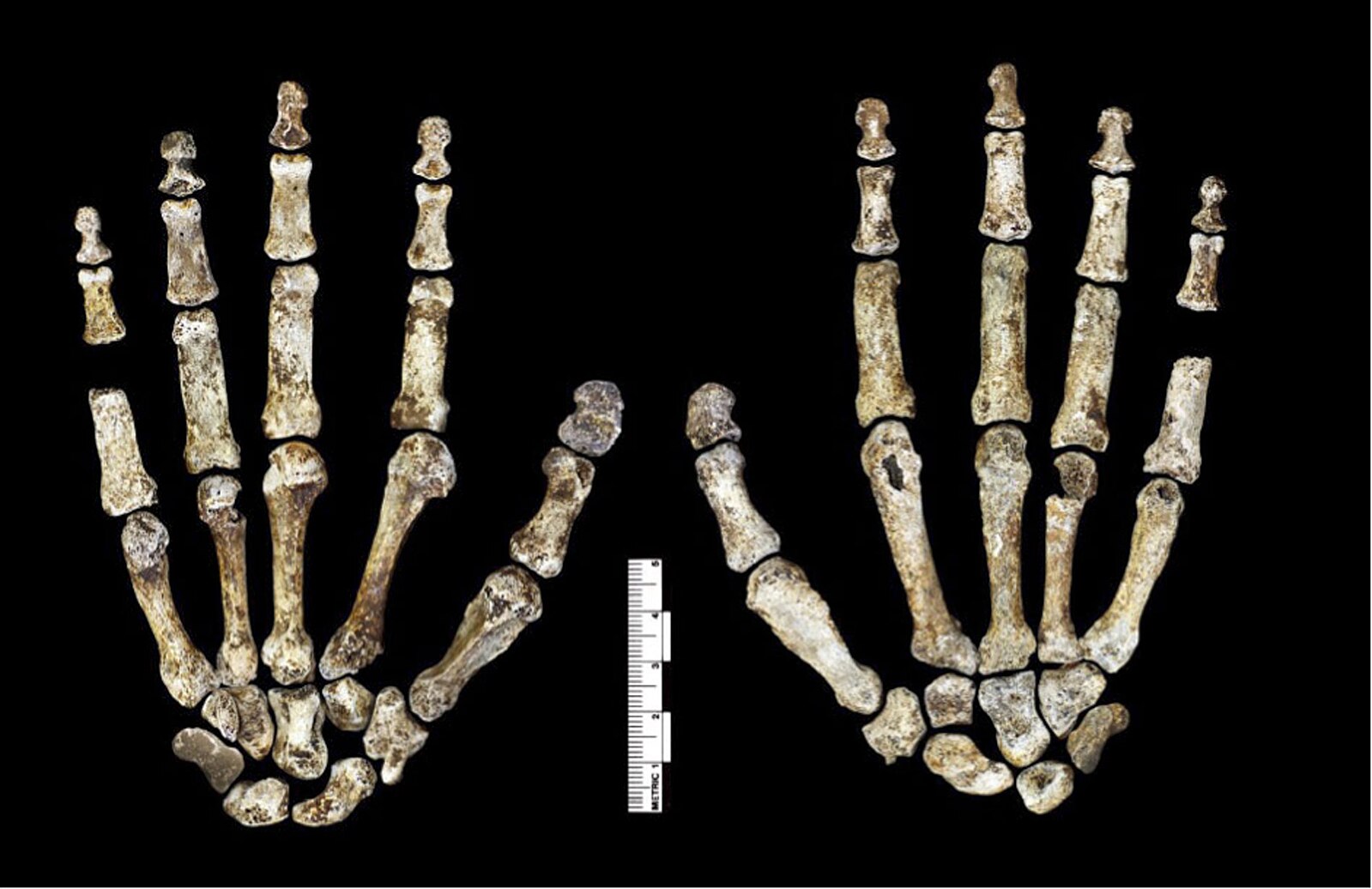
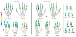
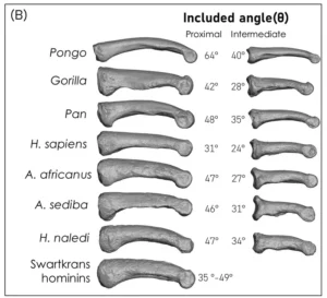
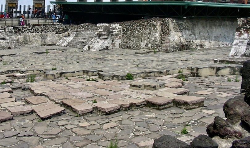
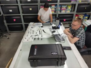
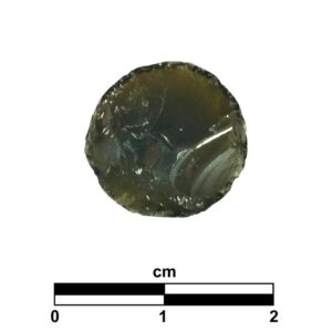
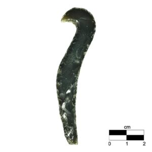
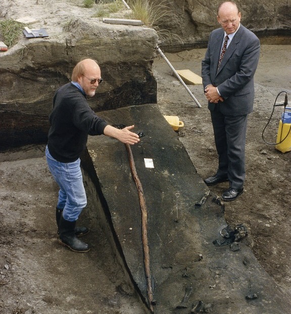
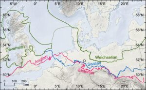
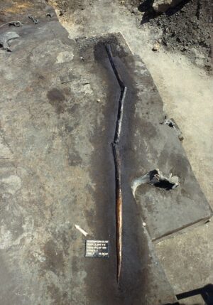
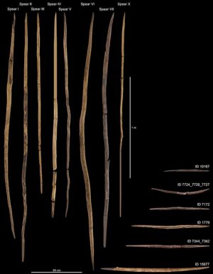

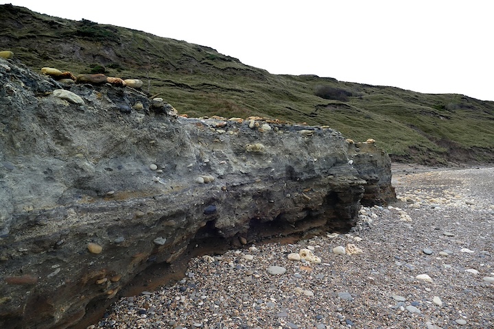

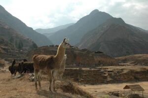
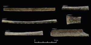
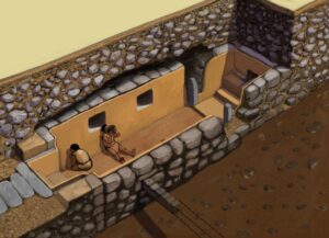
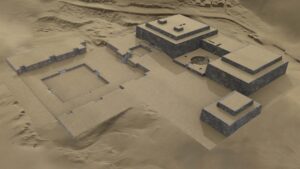
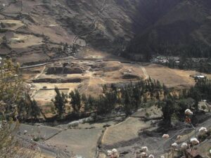
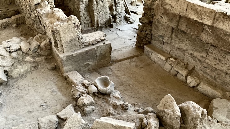
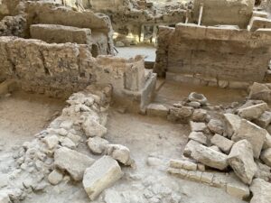
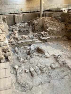
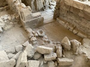
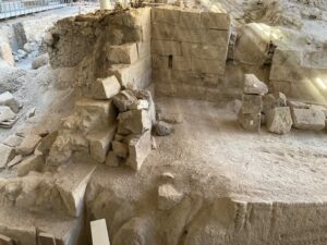
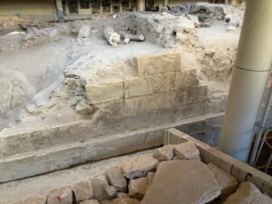
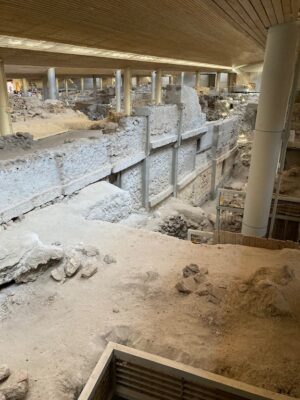
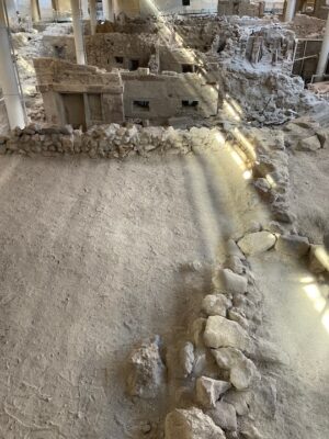
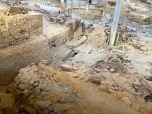
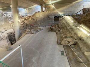
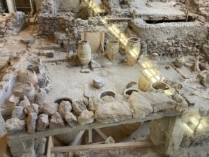
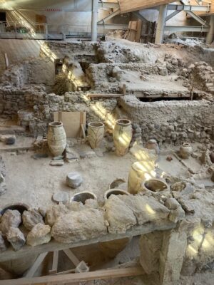
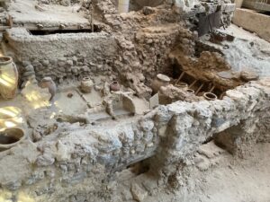
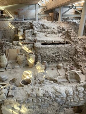
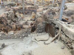
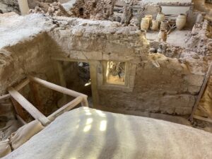
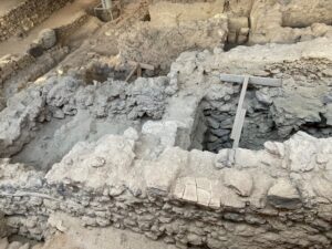
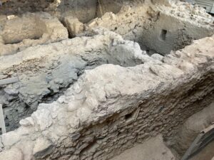
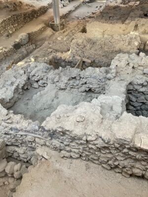
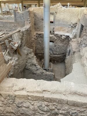
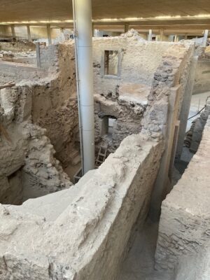
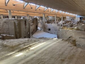
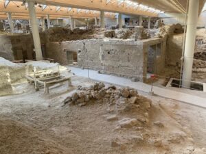
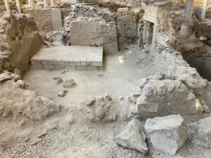
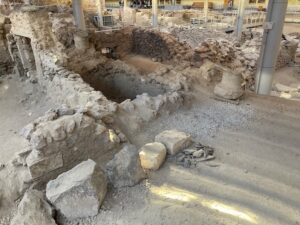
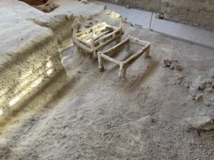
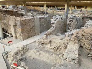
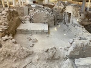
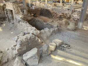
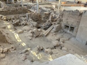
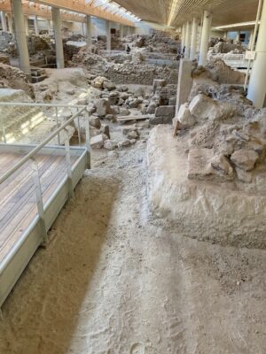
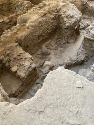
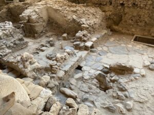

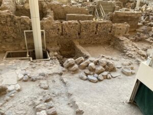
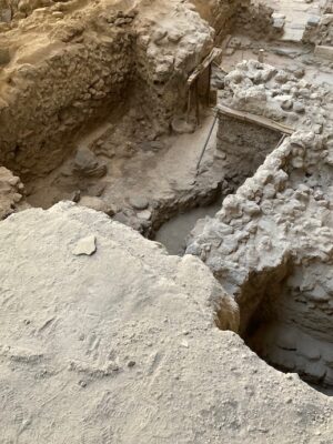


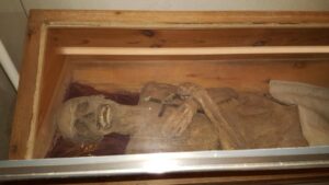
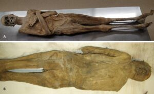
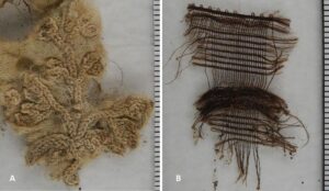
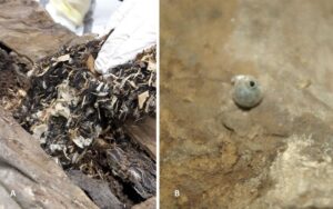
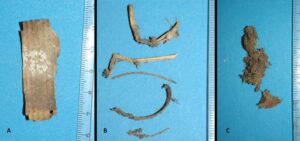
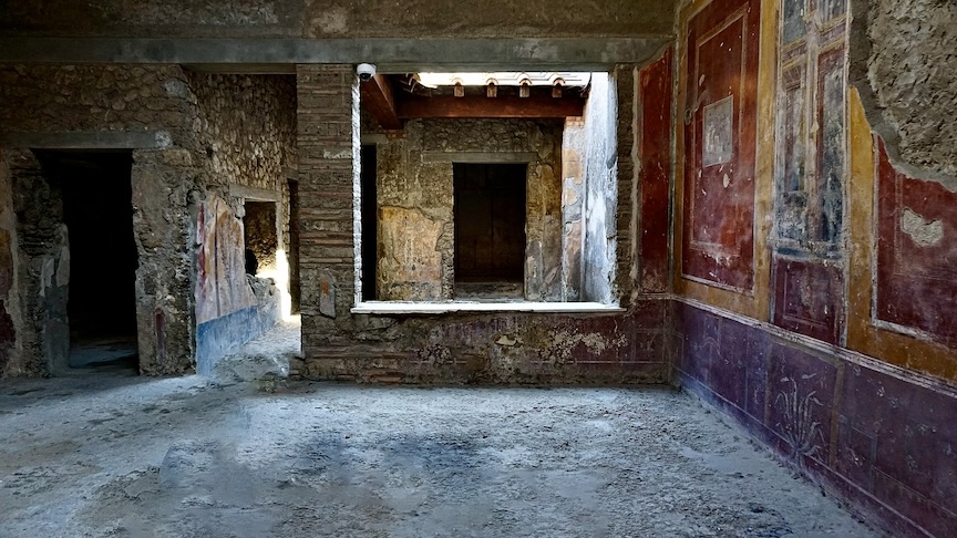
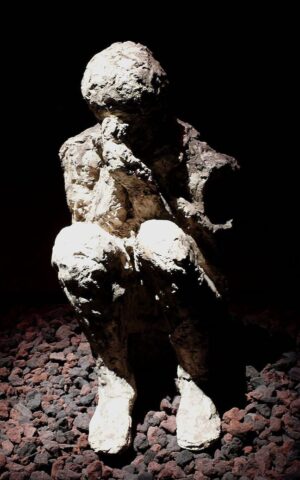
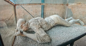
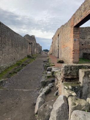
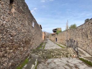
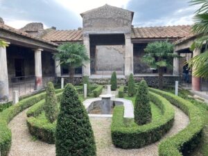
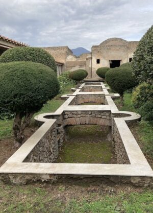
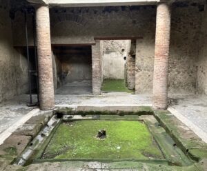
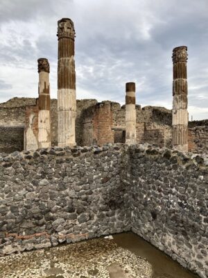
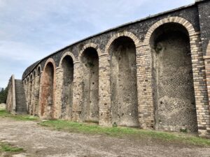
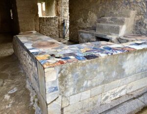
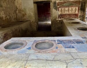
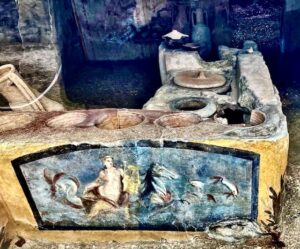
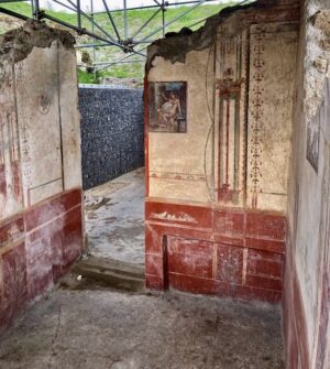
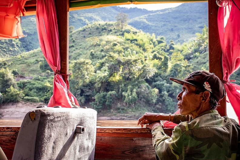


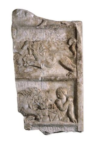
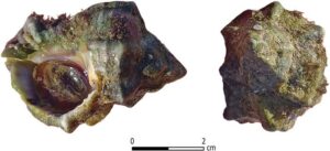
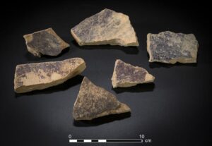

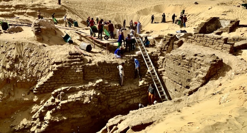
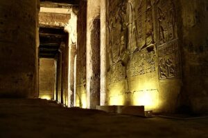

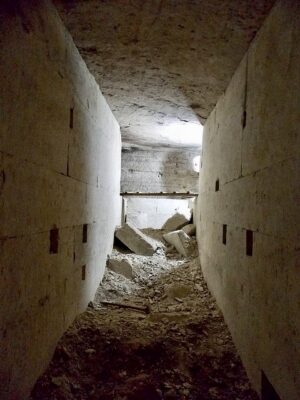
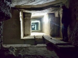
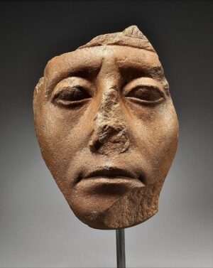
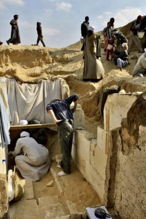
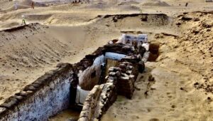
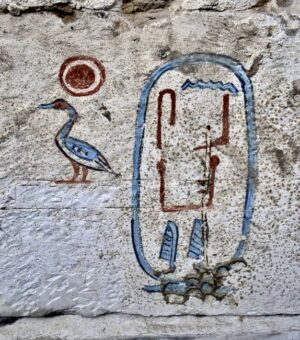
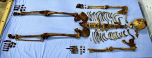
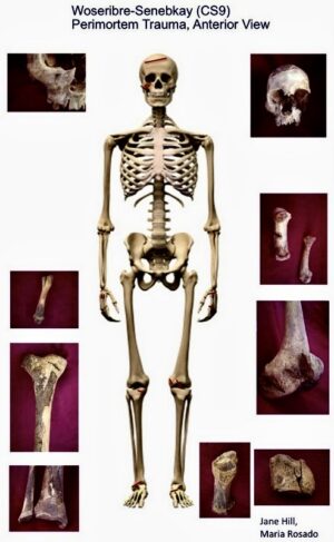
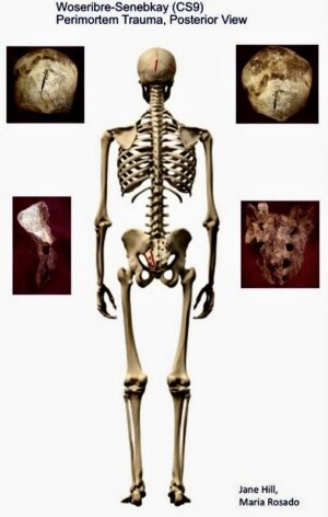
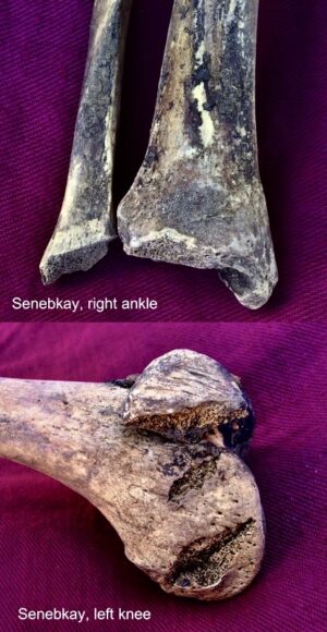
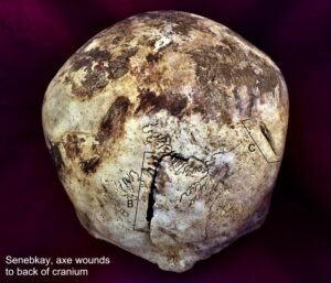
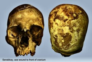
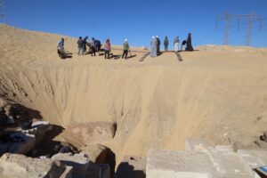
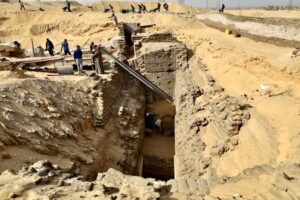

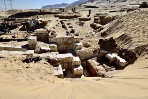
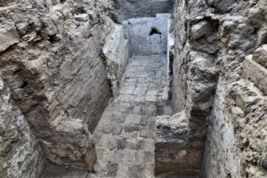
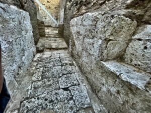
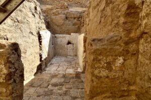

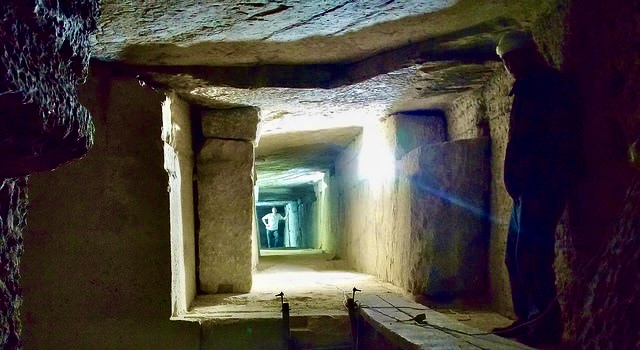
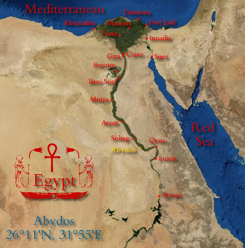
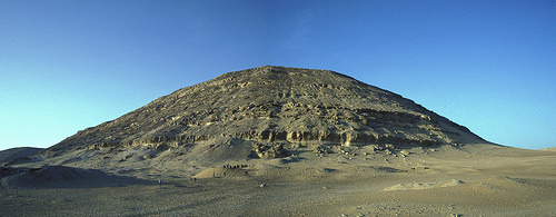
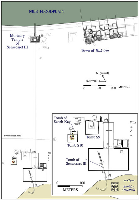
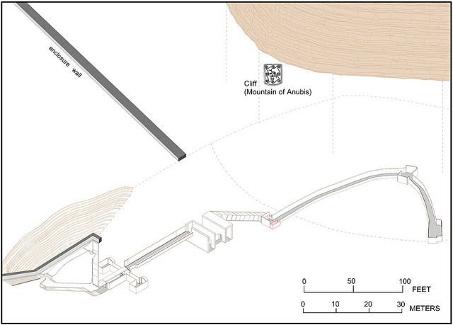
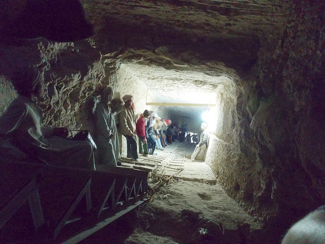
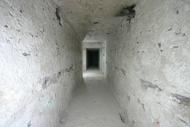
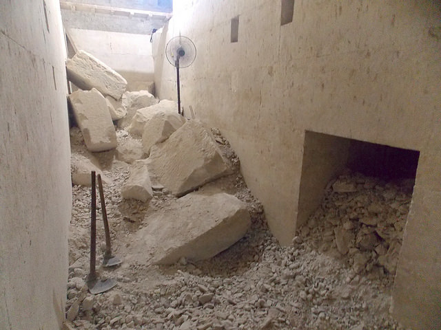
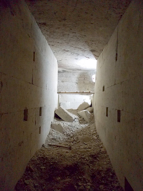
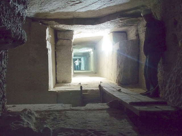
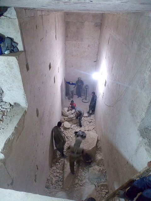
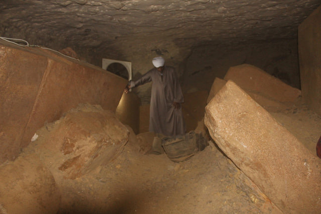
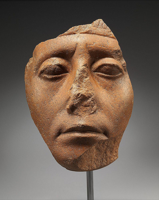
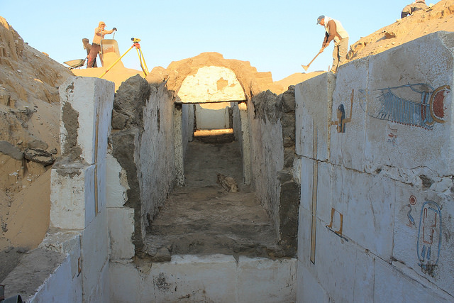
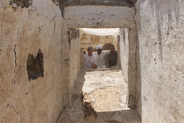
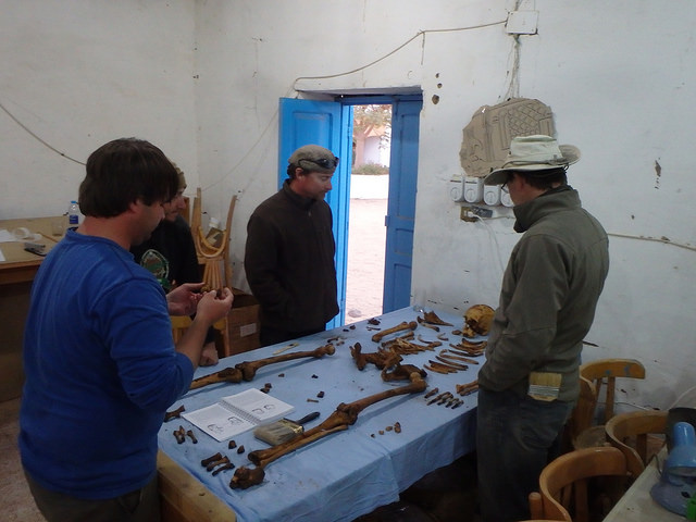
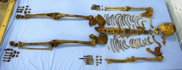
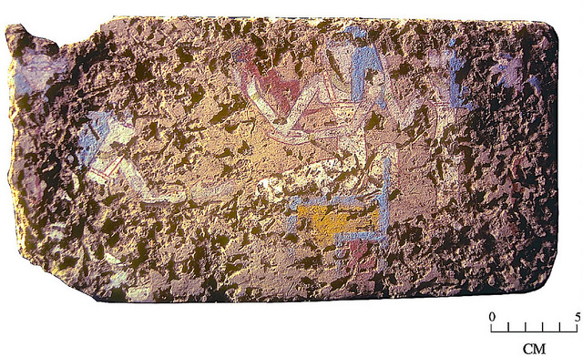
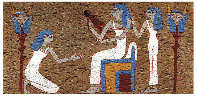

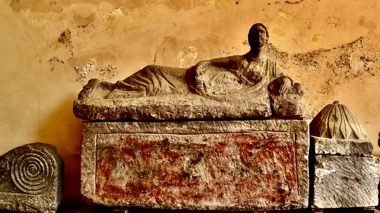


