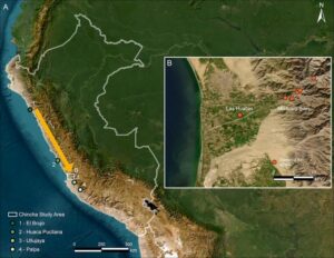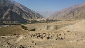
Khirbet Qeiyafa, in Israel, is located on the summit of a hill that borders the Elah Valley southwest of Jerusalem. This would have been a key strategic location in the biblical Kingdom of Judah, on the main road from Philistia and the coastal plain to Jerusalem and Hebron in the hill country. Even prior to excavation, visitors to Khirbet Qeiyafa could discern a massive city wall, 2–3 m in height, encompassing the summit of the hill. This city wall demarcates an area of 2.3 hectares with a total length of ca. 700 m. Due to the local topography, only the external face of the wall is exposed, the inner part buried under archaeological remains. The base of the wall is composed of cyclopean stones, some weighing 4–5 tons, while its upper part is built with medium-sized stones. Two city gates were already located prior to their excavation, one in the south and one in the west (Figs. 1–3).
____________________________________

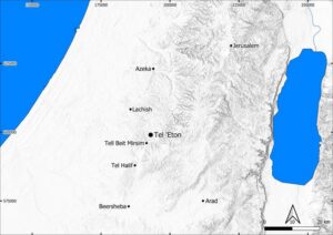
Fig. 1. Map of the southern Levant and the location of Khirbet Qeiyafa.
___________________________________
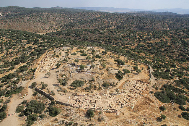
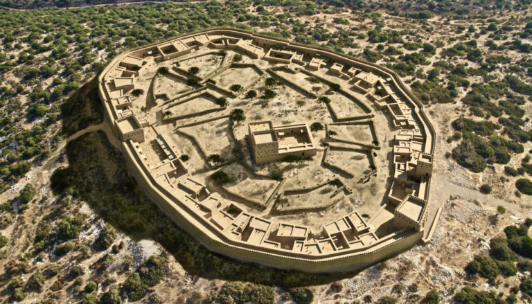
Fig. 2. Aerial photograph of Khirbet Qeiyafa at the end of the 2012 excavation season, view to the north (sky view).
__________________________________

Fig. 3. An aerial photo of the Elah Valley and the city wall of Khirbet Qeiyafa in the lower right corner (Photograph by Sky view).
____________________________________
The history of research of Khirbet Qeiyafa started in the mid 19th century, when it was reported by the French explorer V. Guerin in the year 1868. In the British Survey of Western Palestine in 1883 Khirbet Qeiyafa was described in only a few words: “heaps of stones”. During the 20th century, the site was neglected; it is not referred to in the works of the leading scholars in the field of biblical historical geography, but is mentioned in a few surveys conducted in the 1980s and 1990s by Y. Dagan and Z. Greenhut. None of these surveys, however, recognized that the site represented a heavily fortified city of the early 10th century B.C.
Seven excavation seasons (2007–2013) were conducted at Khirbet Qeiyafa by Y. Garfinkel and S. Ganor on behalf of the Institute of Archaeology of the Hebrew University of Jerusalem. In the years 2009–2011 the expedition included M. G. Hasel of the Southern Adventist University.
A number of periods are represented at the site: Late Chalcolithic, Middle Bronze Age II, Early Iron Age IIA, Late Persian-Early Hellenistic, Roman, Byzantine and Islamic. However, the main period of occupation, with most of the preserved accumulation, belongs to the heavily fortified city of the Iron Age IIA. According to radiometric datings, this city existed in the early 10th century BCE, the time of King David. This writing concentrates only on this phase in the history of Khirbet Qeiyafa.
The 2007–2013 Excavations and Field Results
Thanks to the shallow accumulation and the massive stone construction, it was possible to uncover a large part of the city during a relatively short time. The excavation was carried out in six areas, in which the following remains from the biblical period were discovered (Figs. 4–5):
Area A: In this area, located in the center of the city at its highest point, we uncovered remains of a palace – a large structure with long and exceptionally thick walls – that likely served as the administrative center for the city and the lowlands region.
Area B: In this area, located in the western part of the city, a city gate was found, as well as a casemate wall and dwellings abutting the wall.
Area C: In this area, in the southern part of the site, excavation revealed the second city gate, a gate piazza and six large dwellings abutting the wall.
Area D: This area, in the western part of the city, adjoins Area B. It was excavated by Michael Hasel and his staff from the Southern Adventist University. Here a casemate wall was uncovered along with a large gate piazza that abutted the Area B gate; south of the piazza a dwelling was found abutting the wall.
Area E: In this area, in the eastern part of the city, a small portion of the casemate wall surrounding the city was found.
Area F: In this area, located in the northern part of the city, we revealed 50 m of the city wall. Abutting the wall was a large storehouse, which originally contained two rows of large stone pillars.
___________________________________

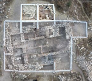
Fig. 4. Plan of the Iron Age city of Khirbet Qeiyafa at the end of the excavation project.
_______________________________________________
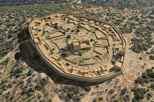
Fig. 5: Visualized reconstruction of the city layout and features based on archaeological investigation. Reconstruction by Architect Roy Albag, Bible Lands Museum Jerusalem
___________________________________
Thanks to the large horizontal exposure we uncovered a large part of the fortifications and entire structures, thus revealing the urban character of the city. Six main components of the city were distinguished:
City Wall
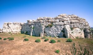
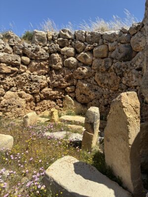
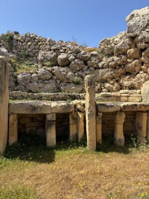
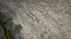
The casemate wall that surrounds the city stood partially exposed before the start of the project, and its outline could clearly be observed. We found that the wall was 4 m wide and was preserved in places to a height of 3 m. At every point where we dug to the base of the wall, we could see that it had been built directly on bedrock. The fortifications consisted of two parallel massive stone walls. Short internal cross-walls divided the city wall into long, narrow rooms. These rooms are called casemates, hence the name of this type of wall (Figs. 6–8).
____________________________________

Fig. 6. Aerial photograph of Area B showing the thick casemate city wall and houses abutting the casemate city wall. On the right side is the western city gate, with its four-chambers, a drain on the central passageway, and a monumental threshold (photograph by Sky view).
__________________________________
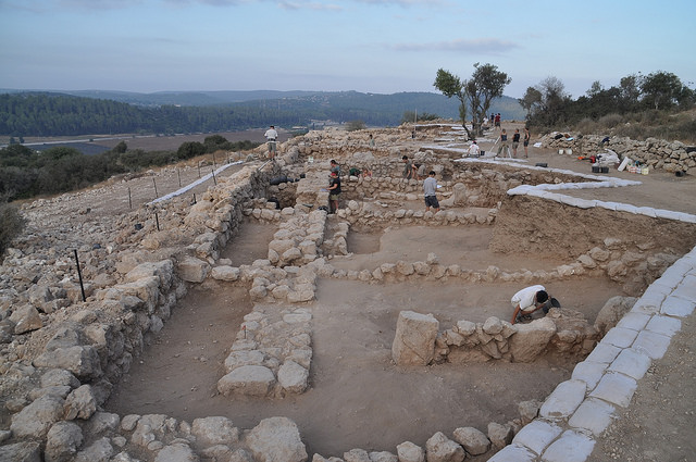
Fig. 7. Area C: The thick casemate city wall (on the left) and houses abutting the city wall from inside the city (photo by Y. Garfinkel).
___________________________________________

Fig. 8. Area C: the thick casemate city wall in the lower part of the picture, and the thin walls of the houses abutting the city wall from inside the city and including the casemates as part of the house (Photograph by Sky view).
______________________________________________
Two Gates
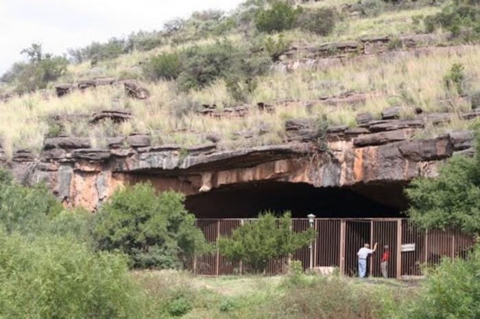
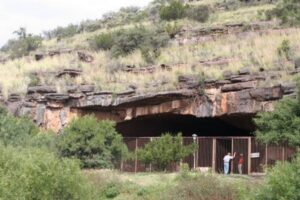
The entrance to the city was via two gates, one in the south and the other in the west. The two gates were very similar in plan. Each had four chambers and a drainage channel on the left side of the passage (from the perspective of a person entering the city). The main gate was the southern one, its importance highlighted by two huge stones set in the entrance, the larger of which weighed about 8 tons. This is one of the most impressive gate façades from the First Temple period ever discovered. The locations of the gates conform to the network of roads leading from the city. A road from the southern gate leads to the Elah Valley and continues eastward to Jerusalem, Bethlehem and Hebron, while a road from the western gate leads to Philistia and the Mediterranean coast (Figs. 6, 9).
___________________________________
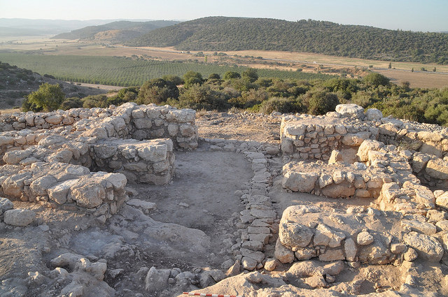
Fig. 9. The southern gate of Khirbet Qeiyafa, leading down to the valley of Elah.
_______________________________________________
Two Gate Piazzas
Near each gate was a piazza – a broad open area of several hundred square meters – which was separated from the rest of the city by a wall. The southern piazza was about 20 m long and the western piazza about 30 m long. Beside each of the piazzas was a dwelling in which one room, abutting the piazza, had a cultic function. The Bible describes a variety of activities in city gates: markets and commerce, judgment and punishment, political announcements, prophecies and religious activities. In our city we found that a specific and delimited area for such activities was set aside near each gate.
Private Dwellings at the Periphery of the City
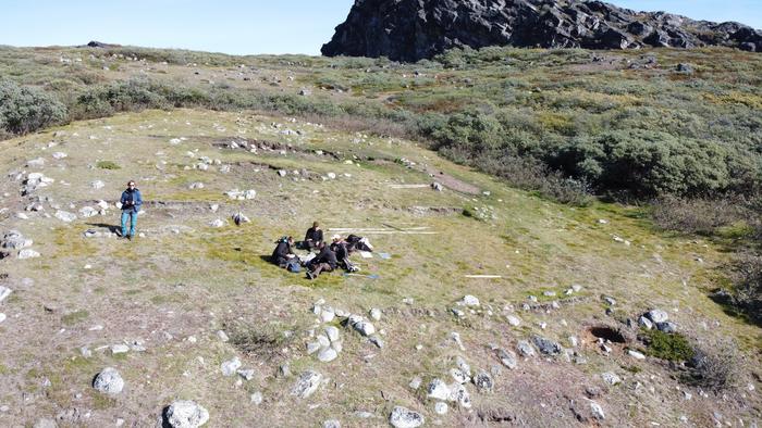
Next to the casemate wall were simple dwellings attached to the wall in such a way that the casemate was the back room of the house. The houses adjoin one another other, sharing an outer wall. Some of the houses are the width of one casemate, while others are the width of two or even three casemates. We were able to discern corridors, courtyards and rooms in these houses. The internal division of the houses in the city varied from structure to structure, but the principle in common was usually several dwelling units built around a shared courtyard, each structure apparently serving a number of nuclear families who lived together as an extended family. The structures we uncovered were residential, but in some cases they had additional rooms that served other purposes, such as stables, storerooms and cult rooms (Figs. 7, 10).
_____________________________________

Fig. 10. Schematic plan of the buildings in Area C. Two cultic rooms were found in this area: Room G in Building C3 and Room G in Building C10.
________________________________________________
Urban planning in which dwellings abutted a casemate wall is known at four additional sites: Tell en-Nasbeh, Beth Shemesh, Tell Beit Mirsim and Beersheba. These sites, like Khirbet Qeiyafa, were within the territory of the Kingdom of Judah as defined in the biblical account. The palace and storehouse at Khirbet Qeiyafa are clear evidence of state-sponsored construction and administrative organization. This is decisive proof of the existence of a kingdom or polity that had established control at strategic geographic points.
Public Storage Building
In the northern part of the city, in Area F, we unearthed a pillared building measuring 6 x 15 m. There were originally two straight rows of large stone columns along the length of the hall, dividing it into three long, narrow spaces. Such pillared buildings have been uncovered in various cities from the First Temple period in the Land of Israel. Such structures, which look very different from dwellings, were typically used as storerooms to hold agricultural products collected as taxes by the state.
The Palace on the City’s Summit
The second large public building was found at the highest point of the site. We uncovered a portion of the palace of what was likely the city’s governor – a large courtyard dwelling that was originally about a thousand square meters in area. Unfortunately, most of the palace was destroyed some 1,400 years after its construction when a fortified farmhouse was constructed here in the Byzantine period. The remains include a row of rooms on the south and another row on the west. There were apparently one or two large courtyards in the center of the structure. Structures of this basic type are known in the Land of Israel in a number of Canaanite palaces from the Late Bronze Age. Their walls are exceptionally thick, two or three times the thickness of the walls of ordinary buildings. At Khirbet Qeiyafa, for example, walls of dwellings are 30–40 cm thick, while the walls of the palace are up to one meter thick. This extraordinary thickness indicates that they supported the weight of a number of stories above the ground floor. Various installations were found near the palace, one of them attesting to a metal industry. Rare pottery vessels such as a black juglet and an alabaster vessel imported from Egypt were also found.
This large structure at Khirbet Qeiyafa is distinctive in four aspects: its location at the highest point in the city, its position in the center of the settlement, its extraordinary size and the thickness of its walls. The elevated location enabled control of the houses in the lower part of city while providing an expansive view from the Mediterranean in the west to the mountains of Hebron and Jerusalem in the east. That would have made it a particularly suitable place for the transmission of fire signals.
The Major Small Finds Categories
A sudden destruction and abandonment of the city left a very rich assemblage of objects of daily life on the floors and destruction debris in every room. The three largest categories of finds are pottery, stone artifacts, and metal objects (Fig. 11).
_____________________________________
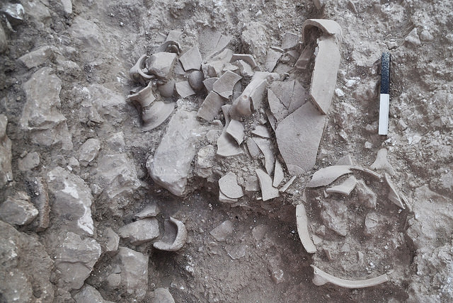
Fig. 11. destruction
____________________________________________________
Pottery
Hundreds of restorable pottery vessels were found, the best example of early tenth-century B.C. pottery ever found that could be attributed to biblical Judah. Until our excavations, the pottery typology of the early Iron Age IIA was poorly known. Khirbet Qeiyafa completely changed this situation. Of special interest are three categories of pottery vessels (Figs. 12–15):
1. The mass production of jars with finger-impressed handles is the beginning of a long tradition in the region of Judah, when the royal administration marked storage jars on handles. Thus, the nearly 700 impressed jar handles from Khirbet Qeiyafa are not coincidental and reflect the beginning of this very long tradition.
2. The painted Philistine pottery, known as Ashdod Ware, uncovered at Khirbet Qeiyafa has enabled us to subdivide this pottery tradition into two groups, earlier and later.
3. Four vessels known as “Black Juglets” were found, three of them originating from Trans- Jordan.
4. Two Cypriot juglets connect Khirbet Qeiyafa with the Mediterranean trade and have far-reaching implications for the dating of these juglets at other sites.
_______________________________________

Fig. 12. The typical storage jar of Khirbet Qeiyafa. Many of them were stamped with a finger impression on one or two handles. These jars were probably used for the collection of taxes, in the form of olive oil, wine, and other agricultural products, as were the royal (LMLK) jars of the eighth century BCE (photo by C. Amit, IAA).
________________________________________________

Fig. 13. The typical finger impression on jar handles from Khirbet Qeiyafa. Nearly 700 such handles were found at the site (photo by C. Amit, IAA).
__________________________________________________

Fig. 14. Ashdod Ware I vessels from Khirbet Qeiyafa, imported from the nearby Philistine territory.
_______________________________________

Fig. 15. A small barrel-shaped juglet of Cypriot Black-on-White ware.
___________________________________________________
Stone Artifacts
Over two hundred stone artifacts were found. These were made from hard limestone, soft limestone, chalk, basalt, beachrock, flint, and other minerals. A few fragments of small alabaster vessels were discovered as well; they are probably indicative of trade relations with Egypt. Basalt is not a local raw material in the Judean Shephelah and had to be imported from volcanic deposits more than 100 kilometers from the site. The appearance of basalt grinding tools at Khirbet Qeiyafa, including quite heavy items, suggests an intensification of economic activities in the early tenth century BCE.
Metal Objects
Nearly 100 metal objects had been unearthed in the Iron Age city, and over thirty iron and bronze tools, mainly weapons, were uncovered. Two pottery crucibles with bronze slag were found as well, indicating that metal was smelted on site. The dominant use of iron rather than bronze should not be overlooked (Fig. 16).
_______________________________________
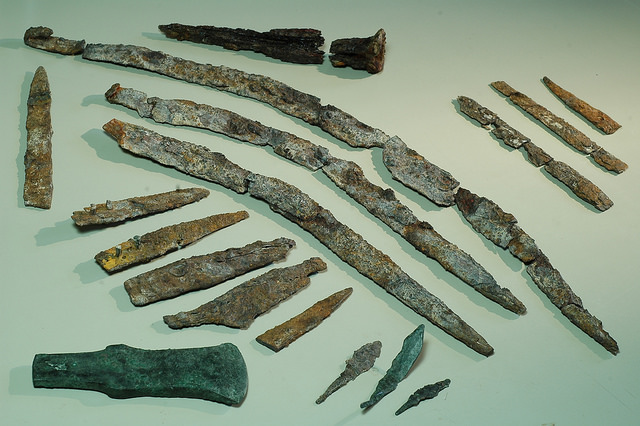
Fig. 16. Various metal objects: iron knives, large iron swords, a bronze axe and bronze arrowheads.
___________________________________________________
Objects of Trade
The large variety of objects imported to Khirbet Qeiyafa points to trade connections with a rather wide geographical spread:
1. Local, regional trade. This category includes trade with the nearby Philistine coastal plain. Petrographic analysis has shown that the Ashdod Ware pottery came from Philistia. In the same way, grinding stones made from beachrock originated from the Mediterranean coast.
2. Interregional trade within the southern Levant. This category includes basalt grinding tools and copper.
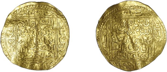
3. International trade. This category includes two Cypriot juglets, Egyptian scarabs and amulets, alabaster vessels, tin for the bronze industry, and a miniature gold leaf.
As with all trade, the immediate question is what was given in return. What goods could the inhabitants of Khirbet Qeiyafa have provided to the inhabitants of the Philistine coastal plain? It seems to us that timber may have been a major commodity that was in short supply in Philistia, since the sandy coastal plain is not an appropriate ecological zone for trees. The large population of the Philistine sites of Ashdod, Ashkelon and Gath, would have needed timber for construction, cooking, and heating. This would create the motivation for regional trade connections between Philistia and the Judean Shephelah.
The Inscriptions
Two inscriptions were found during the excavations (Figs. 17–19).
The Ostracon
This is a large pottery sherd bearing an inscription, written in ink, containing five lines, with a total of some seventy letters. The letters are written in an archaic style in the Canaanite writing tradition (also known as “Proto-Canaanite”). This is the longest inscription in this style ever found, and the longest extant inscription from the 12th to 9th centuries BC in the region. It is also one of only a few inscriptions to be uncovered in clear stratigraphic context and its date, ca. 1000 BC, is certain. Nearly 20 scientific articles had been written on this text, yet its reading is not clear.
The Incised Jar
The second inscription was incised before firing from right to left on the shoulder of a pottery storage jar. The letters are large and clear, similar in size and evenly spaced, written by a skilled hand in Canaanite script. A short, straight vertical line (a word divider) appears between each pair of words. The inscription includes a personal name: Eshbaal son of Beda‘. The name Beda‘ is unique, while Eshbaal is known from the Bible but has never yet appeared on an ancient inscription. The few first letters of the inscription are not fully preserved but, in the context of an incised inscription on a large container, it seems that the first word implies that the jar’s contents came from the field/estate of Eshbaal son of Beda‘.
_______________________________________

Fig. 17. Photograph of the Khirbet Qeiyafa ostracon taken at the Megavision laboratory.
________________________________________

Fig. 18. Drawing of the Khirbet Qeiyafa ostracon by Ada Yardeni.
___________________________________________________

Fig. 19. The ʾIšbaʿal inscription was incised on the storage jar before firing.
______________________________________________________
The Cult at Khirbet Qeiyafa
Substantial data on the cult of the inhabitants were obtained, including:
Standing Stones.
The standing stone, the biblical massebah, is one of the more common cultic objects in the ancient Near East. Typically, it is an elongated stone with a rounded top that was placed on its narrow end. In most cases a natural stone was chosen for this purpose and signs of intentional shaping are absent or minimal. Seven standing stones were uncovered in the city.
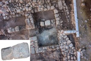
Cultic Room in Building C3 (Figs. 20–23).
The room was equipped with special installations and finds, including a bench, a sink-hole with a connection to a drainage system that was found in the adjacent room to the south, two standing stones, an offering table, a rounded installation built of stones and containing a Black Juglet, a rectangular installation in the southeastern corner, and a limestone basin. The room is notable for the rich destruction debris accumulated on its floor, which included, as well as a very large amount of pottery vessels and cultic paraphernalia: a basalt altar, a libation vessel consisting of two conjoined round cups, a seal and an Egyptian scarab.
__________________________________________

Fig. 20. The cultic Room G in Building C3, with the Valley of Elah in the background.
___________________________________________

Fig. 21. Two standing stones found in Cultic Room G in Building C3.
_______________________________________________________
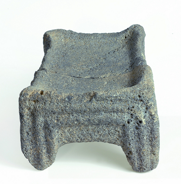
Fig. 22. A basalt altar restored from two parts, each found on a different side of Cultic Room G in Building C3.
_________________________________________________________

Fig. 23. Twin-cup pottery libation vessel from Cultic Room G in Building C3.
____________________________________________
Cultic Room in Building D1
Immediately after the western gate piazza, a cultic room was found. This room was furnished with a bench, a standing stone and an offering table, and contained among other finds three iron swords. A libation vessel with two rounded cups of the type found in the cultic room of Building C3 was found in an adjacent room.
Cultic Room in Building C10 (Figs. 24–27).
Immediately after the southern gate piazza, a cultic room was found. Two exceptional artifacts uncovered in the room are model shrines, one made of clay and the other of limestone:
“Model shrine” made of clay: This item is 11 cm wide and 16 cm high. While the sides and back are simple, the façade is elaborately decorated to resemble a temple entrance, including two lions, two columns, ribbons tied to the columns and four beams above the entrance, above which is a rolled curtain. On the beams are circles scored with vertical parallel lines, apparently representing roofing beams laid perpendicularly to the entrance and extending beyond it. Three birds perch on the roof. Further analysis of the significance and function of this artifact is presented below.
“Model shrine” made of limestone: This artifact, 21 cm wide, 26 cm long and 35 cm high, was carved from a single block of soft limestone. Traces of red paint are visible on the exterior. While the sides and back are simple, the façade is elegantly profiled. In the center of the façade is a large rectangular doorframe, 10 cm wide and 20 cm high, formed by three recessed frames. Between the doorframe and the roof is a row of protruding rectangular elements, each divided by deep incisions into three narrow parallel rectangles. Four of these protruding elements are fully preserved and traces of three others are visible. This is the triglyph, a common element in classical architecture.
Iconographic analysis of this building model, undertaken by the author and Madeleine Mumcuoglu, enabled us to better interpret the various technical terms in the biblical description of Solomon’s palace and temple (Fig. 28)
_________________________________________________

Fig. 24. The cultic room and nearby city wall casemate in Building C10. Two model shrines were found here, one made from clay, the other from limestone.
__________________________________________________
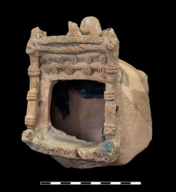
Fig. 25. Clay model shrine from Rooms G and H in Building C10, after restoration.
_________________________________________________

Fig. 26. Limestone model shrine from Room G in Building C10, after restoration.
_________________________________________________

Fig. 27. Trigliphes
__________________________________________________
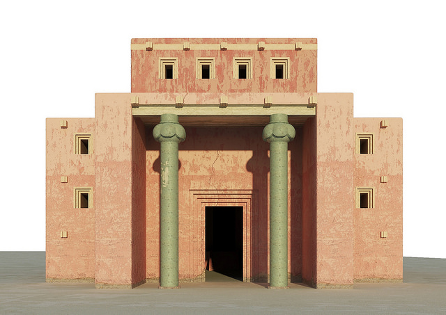
Fig. 28. Reconstruction of Solomon’s temple
_____________________________________________________
Khirbet Qeiyafa Dating
Two radiometric dating projects were conducted by the expedition. Already in the first few years (2008–2010) olive pits from various contexts in the city were processed at Oxford University. The results suggested at the 68.3% confidence level that the destruction of the city took place between 1012 and 967 BC. However, our interpretation of these results has been criticized on the grounds that the olive pits were collected from various contexts and thus should not be averaged. In this view, the earlier dates represent the construction of the city and the later dates represent its destruction. Hence, the single-phase city existed from ca. 1050 to 925 BC. What was needed, according to this critique, was a secure context containing a large number of short-lived samples.
In the 2012 excavation season such a secure context was found: a pottery storage jar containing some 20 burnt olive pits found in the destruction layer of the city. The jar was uncovered in Building C10 near the southern city gate. Firstly, all the olive pits came from a well-controlled context, a closed container that minimized the chance of contamination (isolated olive pits can travel up and down the sediment of a site and the location in which an object is found is not always that of its original deposition). Secondly, the short-lived nature of olives suggests that they were harvested in the very last years before the destruction of the city. After this discovery, a second dating project was initiated.
In the second radiocarbon dating project 17 samples of olive pits were analyzed, 12 at Belfast and 5 at Oxford. The results clearly indicate that the destruction of Khirbet Qeiyafa took place in the first third of the 10th century BC (ca. 1000-970 BCE)
Khirbet Qeiyafa and the Debate over the Historicity of the Hebrew Bible
In order to understand the contribution of Khirbet Qeiyafa to the debate over the historicity of the Hebrew Bible one must consider the developments in the field of Biblical archaeology and Biblical history in the last 40 years (Fig. 30). This debate can now be divided into three phases, and Khirbet Qeiyafa is at the focus of the second and the third of these (Garfinkel and Ganor 2008, 2009).
Phase I. The Mythological Paradigm
In the mid-1980s, new approaches developed concerning the historicity of the biblical narrative. The main argument revolved around dating the final writing of the Hebrew Bible. Particularly relevant to our discussion is the narrative of the tenth century BCE, the period known as the United Monarchy. The so-called “Minimalist” school claims that the Hebrew Bible was written in the Hellenistic period, nearly 700 hundred years after the time of David and Solomon, and therefore the description of that era is a purely literary composition.
In 1993 and 1994, several fragments of an Aramaic stele were found at Tel Dan, dated to the ninth century BCE. This text specifically mentions a king of Israel and a king of the “House of David”, that is, a king of the dynasty of David (Fig. 31). Reference to the “House of David” has consequently been identified on the Mesha Stele, also dated to the ninth century BCE. Thus, there is at least one, and possibly two, clear references to the dynasty of David in the ninth century BCE, only 100–120 years after his reign. This suggests evidence that David was indeed a historical figure and the founding father of a dynasty, contrary to the claims of the Minimalists.
An interesting side-effect of the collapse of the minimalist paradigm was the panic reaction of its proponents, leading to a number of suggestions which now seem ridiculous: “House of David built on sand”, “Did Biran kill King David?” or “Eponymic referent to Yahweh as Godfather”. Another linguistic manipulation suggested that the stele reference should be read as a place-name called Bethdod, in parallel to the known place-name Ashdod. Nowadays, articles of this type can be classified as displaying “Paradigm-Collapse Trauma”—literary compilations of groundless arguments, masquerading as scientific writing through footnotes, references and publication in professional journals.
The Tel Dan stele ended the first phase of the debate regarding the historicity of the Hebrew Bible, clarifying that the mythological paradigm was nothing but a modern myth.
Phase II. The Low Chronology Paradigm
After the collapse of the mythological paradigm, a new strategy was developed by the Minimalists. This time, the central method was to lower the dating of the transition between Iron Age I and Iron Age II from c. 1000 BCE, as was accepted until then (commonly called “high chronology”), to c. 925 BCE (“low Chronology”). A more extreme approach even lowered the transition to as late as c. 900 BCE (“ultra-low chronology”).
What was achieved by these low-chronology suggestions?
The Iron Age I in Judah and Israel was a period of agrarian communities organized in a tribal social organization (described in the biblical tradition as the period of the Judges). The next period, the Iron Age II, was a period of urban society and a centralized state organization (described in the biblical tradition as the period of the Kings). Low chronology placed urbanization only at the end of the tenth century BCE, thereby indicating that David and Solomon were not rulers of a kingdom but local tribe leaders.
In the last decade, hundreds of organic samples from Iron Age sites were sent for radiometric dating in order to verify or contradict the low chronology. Initially, various methodological problems and mistakes were made regarding radiometric dating of such archeological samples. These include the type of material used for dating, the context from which the sample is retrieved, the selection of dates and statistical analysis.
Once the various problems were understood and corrected, the advocates of low chronology declared without hesitation that the dating results of hundreds of samples clearly supported low chronology.
This situation is altered completely thanks to the recent excavations at Khirbet Qeiyafa. The site cannot be later than c. 970 BCE. This date fits the period associated with King David (c. 1000–965 BCE) and is too early for King Solomon (c. 965–930 BCE). The fortified city of Khirbet Qeiyafa indicates that the Iron Age IIA in the southern Levant began at the very end of the eleventh century BCE, thus rendering the low chronology paradigm nothing but a modern myth.
In this context, it was indeed a pleasant surprise to see the article by Finkelstein and Piasetzky where they show that Canaanite sites in northern Israel, like Megiddo, have destruction levels dated to c. 1,000 BCE. This is exactly the dating indicated by the traditional high chronology decades ago. Thus, Finkelstein is not only the founding father of low chronology, but also its undertaker. Dating the end of major Iron I sites to c. 1,000 BCE fits perfectly with the dating of Khirbet Qeiyafa. This very early Iron IIA border site was destroyed shortly after its construction.
Phase III. The Ethnic Identification of Khirbet Qeiyafa
Khirbet Qeiyafa is located on the border between Judah and the Philistine region, and could, therefore, be associated with either of these. If it was a Judaean site it indicates that fortified cities were built in Judah, so David and Solomon were not shepherds living in tents. This situation supports the Biblical tradition.
Here begins the third phase in the evolution of the minimalist approach. The basic minimalist argument is very simple: even if David was a historical figure (given the Tel Dan stele), and even if the transition from Iron Age I to Iron Age II began at the end of the eleventh century BCE (given the dating of Khirbet Qeiyafa), there was still no kingdom in Judah at the tenth century BCE. For this assumption to be true, Khirbet Qeiyafa must be a non-Judean site. Conversely, the identification of Khirbet Qeiyafa as a Judean city would indicate that David was indeed a meaningful king, who built fortified cities in strategic border locations. Thus, the first attempt of the Minimalists is to classify Khirbet Qeiyafa as a non-Judean city. In this way it was suggested that the site was a Philistine city, a Canaanite city, or a city in the Kingdom of Israel built by King Soul. None of these suggestions however took into consideration the data uncovered at the site of Khirbet Qeiyafa. Needless to say, if the proposed identifications fail, there are still more ethnic candidates for the population of Khirbet Qeiyafa — the various other nations mentioned in the Bible: Hittites, Girgashites, Amorites, Perizzites, Hivites and Jebusites (Deut. 7:1).
The Khirbet Qeiyafa expedition did not take part in the long-standing minimalist debate and has nothing to gain or lose if the site is identified as Judean or Philistine. Thus, we remain open-minded in evaluating the evidence. As it seems now, the identification of Khirbet Qeiyafa as a Judean site is supported by various site characteristics and elements. The main ones are:
1. Settlement pattern: Fortified field cities are known only in Judah. In Philistia, only the five large capital cities were fortified.
2. Character of the fortifications: Casemate city walls are not known in Philistia, but in Judah.
3. Orientation of the entrance to the city: The main entrance to Khirbet Qeiyafa faced Jerusalem.
4. No pig or dog bones were found at Khirbet Qeiyafa, while in Philistine Gath, these animals were part of the diet, as indicated by the bone remains found at Tell es-Safi.
5. At Khirbet Qeiyafa, a pottery baking tray was found in each of the buildings uncovered in the 2008 season. Such baking trays were not found at Philistine sites; and
6. The language of the ostracon uncovered at Khirbet Qeiyafa is Hebrew, according to the epigraphist Haggai Misgav. The inscription published from Tell es-Safi (Philistine city of Gath) contain Indo-European names, while the Khirbet Qeiyafa ostracon displays no such names.
The central question regarding Khirbet Qeiyafa is its relationship with the biblical text, which describes state-formation processes in Judah, King David’s activities, and intensive military clashes against the Philistine city of Gath in the Elah Valley. These biblical traditions are contemporaneous with the settlement of the fortified city at Khirbet Qeiyafa. Thus, our excavations have direct implications for these complex matters. If Khirbet Qeiyafa was a Philistine or Canaanite city or belonged to the Kingdom of Israel, it cannot be connected with the traditions about David and state formation in Judah. If, however, Khirbet Qeiyafa was a Judean city, it is of crucial importance for David and state-formation processes in Judah.
When evaluating the various possible interpretations of Khirbet Qeiyafa, the following distinctive components should be considered:
1. The site was built according to the typical Judaean urban plan, a plan that is not found in any city in the Kingdom of Israel.
2. There are nearly 700 impressed jar handles, a typically Judean administrative device. Impressed jar handles are not found in the Kingdom of Israel in meaningful quantities.
3. The site did not yield the figurines that are characteristic of sites in the Kingdom of Israel in this period.
4. Five early alphabetic (Proto-Canaanite) inscriptions are known today from the tenth century B.C.: three from Khirbet Qeiyafa, one from Beth-Shemesh, and one from Jerusalem. These sites are located in the core area of Judah. Not a single such inscription was found in sites of the Kingdom of Israel.
5. The dominance of iron tools in the assemblage of metal objects is characteristic of Judean sites; in the Kingdom of Israel bronze was dominant at this stage; and
6. The site’s location in the Elah Valley on the main road from the Philistine centers of Ashdod and Ashkelon to Jerusalem had no geopolitical importance for the Kingdom of Israel. In order to defend its supposed territory from Philistine attacks, the northern kingdom would have needed to build fortified cities in the Sorek and Ayalon Valleys.
The material culture of Khirbet Qeiyafa does not accord with the characteristics of the Philistine city states of the coastal plain and lower Shephelah, the Canaanites, or the Kingdom of Israel. On the other hand, all these aspects fit the Kingdom of Judah very well. Indeed, those who raised the idea that Khirbet Qeiyafa could be a site of the Philistines/Canaanites/Kingdom of Israel did not discuss its material culture.
One should also be aware that the finds at Khirbet Qeiyafa do not imply a large kingdom extending all the way to Megiddo or Hazor. In this phase, even Beersheba and Arad were not yet fortified. Thus, Khirbet Qeiyafa represents the first stage in the development of the Kingdom of Judah, which was at that time a relatively small political unit.
_______________________________________

Fig. 30. Three possible models for understanding the establishment of the biblical Kingdom of Judah.
____________________________________________________
Archaeology and King David
Until our excavations at Khirbet Qeiyafa it was indeed very difficult to find Judean sites dated to the early 10th century BCE, the time of King David. Thus, it is not surprising that “minimalist” approaches had been developed. However, the new data from Khirbet Qeiyafa open a new horizon for the study of the very early stage of the Judean Kingdom. The combination of the site location, its massive fortifications, its urban planning, its chronology, central production of jars with stamped handles, the writing and seal, all point to an organized state, not an agrarian community.
____________________________________
Acknowledgments
The Khirbet Qeiyafa Archaeological Project is directed by Yosef Garfinkel and Saar Ganor on behalf of the Hebrew University of Jerusalem, and Michael G. Hasel on behalf of the Southern Adventist University. Other participating institutions include Oakland University and Virginia Commonwealth University and volunteers from over 15 countries. The project is sponsored mainly by J.B. Silver and the Nathan and Lily Silver Foundation.
____________________________________________
Unless otherwise noted, figures and images courtesy the author and the Khirbet Qeiyafa Archaeological Project and Insititue of Archaeology, Hebrew University of Jerusalem.
_____________________________________________
This popular account of the Khirbet Qeiyafa project is based on the following scientific publications:
Y. Garfinkel, 2011. The Davidic Kingdom in Light of the Finds at Khirbet Qeiyafa. City of David Studies of Ancient Jerusalem 6:13*–35* (English), 31–51 (Hebrew)
Y. Garfinkel, 2011. The Birth & Death of Biblical Minimalism. Biblical Archaeology Review 37/3: 46–53.
Y. Garfinkel, 2017. The Ethnic Identification of Khirbet Qeiyafa: Why It Matters? In Lev-Tov, J., Wapnish, P. and Gilbert, A. (eds.) The Wide Lens in Archaeology. Honoring Brian Hesse’s Contributions to Anthropological Archaeology, pp. 149–167. Atlanta: Lockwood Press.
Y. Garfinkel and S. Ganor, 2008. Khirbet Qeiyafa: Sha‘arayim. Journal of Hebrew Scriptures 8: Article 22.
Y. Garfinkel and S. Ganor, 2009. Khirbet Qeiyafa Vol. 1: Excavation Report 2007–2008. Jerusalem: Israel Exploration Society.
Y. Garfinkal, S. Ganor and M.G. Hasel, 2014. Khirbet Qeiyafa Vol. 2. The 2009–2013 Excavation Seasons. Stratigraphy and Architecture (Areas B, C, D, E). Jerusalem: Israel Exploration Society.
Y. Garfinkel, S. Ganor and M.G. Hasel, in press. Footsteps of King David in the Valley of Elah. London: Thames & Hadson.
Y. Garfinkel, S. Ganor and J.B. Silver, 2017. Did the Ancient City of Khirbet Qeiyafa/Sha’arim have two gates? Biblical Archaeology Review January/February 51/1:37–42, 59.
Y. Garfinkel, M.R. Golub, H. Misgav and S. Ganor, 2015.The ʾIšbaʿal Inscription from Khirbet Qeiyafa. Bulletin of the American Schools of Oriental Research 373: 217–233.
Y. Garfinkel, M.G. Hasel and M. Klingbeil, 2013. An Ending and a Beginning: Why We’re Leaving Qeiyafa and going to Lachish. Biblical Archaeology Review 39/6: 44–51.
Y. Garfinkel, I. Kreimerman and P. Zilberg, 2016. Debating Khirbet Qeiyafa: A Fortified City in Judah from the Time of King David. Jerusalem: Israel Exploration Society.
Y. Garfinkel and M. Mumcuoglu, 2013.Triglyphs and Recessed Doorframes on a Building Model from Khirbet Qeiyafa: New light on Two Technical Terms in the Biblical Descriptions of Solomon’s Palace and Temple. Israel Exploration Journal 63: 135–163.
Y. Garfinkel and M. Mumcuoglu, 2016. Solomon’s Temple and Palace: New Archaeological Discoveries. Jerusalem: Bible Lands Museum Jerusalem & Biblical Archaeology Society.
Y. Garfinkel, K. Streit, S. Ganor and M.G. Hasel, 2012. State Formation in Judah: Biblical Tradition, Modern Historical Theories and Radiometric Dates at Khirbet Qeiyafa. Radiocarbon 54: 359–369.
Y. Garfinkel, K. Streit, S. Ganor and P.J. Reimer, 2015. King David’s City at Khirbet Qeiyafa: Results of the Second Radiocarbon Dating Project. Radiocarbon 57/5: 881–890.
A. Gilboa, 2012. Cypriot Barrel Juglets at Khirbet Qeiyafa and Other Sites in the Levant: Cultural Aspects and Chronological Implications. Tel Aviv 39:133–149.
H.G. Kang and Y. Garfinkel, 2015. Finger-Impressed Jar Handles at Khirbet Qeiyafa: New Light on Administration in the Kingdom of Judah. Levant 47: 186–205.
K.H. Keimer, I. Kreimerman and Y. Garfinkel, 2015. From Quarry to Completion: Hirbet Qeiyafa as a Case Study in the Building of Ancient Near Eastern Settelments. Zeitschrift des Deutschen Palästina-Vereins 131: 109–128.
M. Mumcuoglu and Y. Garfinkel, 2015. The Puzzling Doorways of Solomon’s Temple. Biblical Archaeology Review 41/4 (Jul/Aug): 34–41.
S. Schroer and S. Münger (eds.), 2017. Khirbet Qeiyafa in the Shephelah. Papers Presented at a Colloquium of the Swiss Society for Ancient Near Eastern Studies Held at the University of Bern, September 6, 2014. Orbis Biblicus et Orientalis 282. Fribourg (CH): Academic Press.
______________________________