Editor’s Note: Most archaeological excavations and investigations reveal fragments and clues that, given extensive additional research, can tell us much about our past. But nothing can compare to the rich, extraordinarily well-preserved material evidence left to us of ancient cities buried by great cataclysmic volcanic events. Following is an anthology drawn from articles previously published in Popular Archaeology Magazine, edited and combined for presentation exclusively for the magazine’s Instagram readers and those who have not previously had the opportunity to read the stories.
_________________________________________
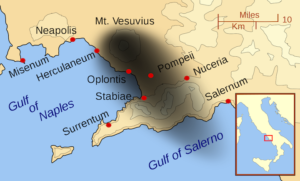
Walking in the Shadow of Vesuvius
A Pictorial
Naples, Italy — Although November is considered the wettest month in this, the third largest city of Italy, my arrival was graced by the sun. My travels would take me to some of the most iconic archaeological sites of southern Italy—Pompeii, Herculaneum, and other ancient towns and cities that fell victim to one of the ancient world’s most terrible calamities—the 79 AD eruption of Mt. Vesuvius.
My first stop, the “mothership” of all open-air museums……
______________________________________
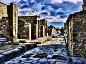
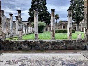
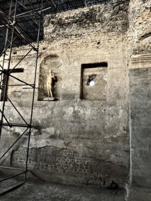
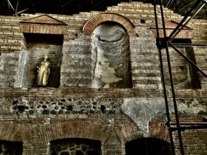
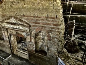
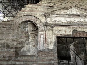
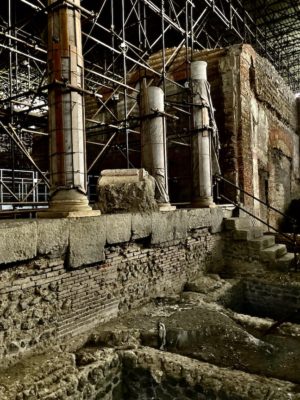
Pompeii
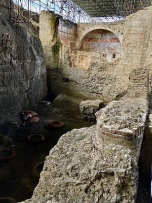
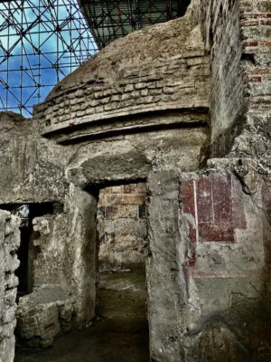
Archaeologically speaking, Pompeii is arguably the world’s most spectacular archaeological site and park. Home to about 11,000 to 11,500 people in its day, the city’s urban footprint spreads across 160 to 170 acres, and archaeological excavations have thus far uncovered about two thirds of the city. Although excavations continue, efforts now focus on specific, smaller areas with designs to achieve certain research objectives. Conservation of current exposed remains also continues to be a major priority of governing authorities for the site.
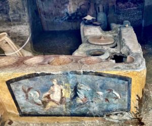
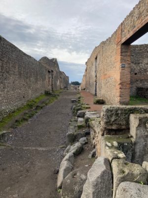
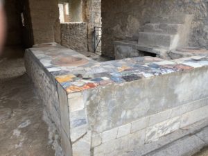
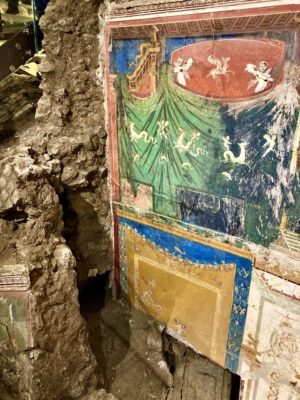
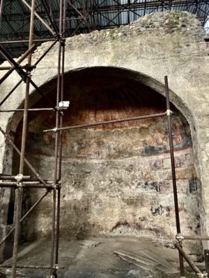
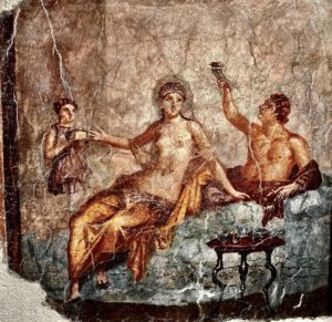
Thus it was no wonder that, given the site’s massive size and complexity, along with the sensational state of preservation reflecting everyday living in the ancient Roman Empire, I allotted myself a full day to explore its remains — not typical of the ‘day’ tours that usually afford but two or three hours. I walked the ancient city streets, through some of the most prominent and spectacular structures and features of the city, including the remarkably well preserved amphitheater. Archaeologists can detail the stories and research findings behind most every major structure and feature of the city, affording an inside, intimate perspective on everyday life. A highlight is time spent at the recent discoveries in Regio V, where archaeologists uncovered, among other things, a well-preserved thermopolium, a cook-shop or snack bar conceptually much like a fast-food shop one would encounter today in the modern world. I imagined the city residents wandering by during its day, some stepping in to purchase a freshly cooked snack or meal, just as one might enter a modern Chipotle or Panera establishment just off the road today. This shop, in contrast to other similar shops I had already observed as I walked along the streets, featured unusually rich painting illustrations, such as a Nereid on horseback in a marine environment, still life scenes and representations of animals likely slaughtered, the meat of which was prepared and sold to customers in the shop.
It is not enough to see pictures and read about Pompeii in the popular literature. The massive site demands a personal encounter with sufficient time to properly absorb it.
_____________________________
_____________________________
_____________________________
_________________________________________
_________________________________________
_________________________________________
_________________________________________

_________________________________________
_________________________________________
_________________________________________
_________________________________________
_________________________________________

_________________________________________
_________________________________________

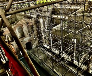
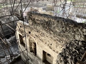
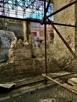
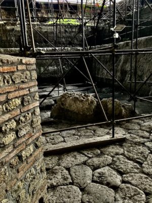
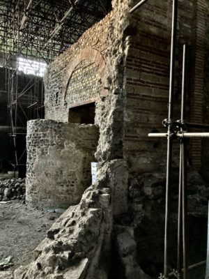
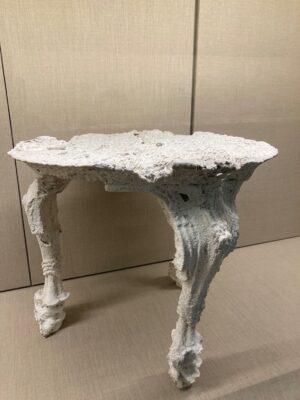
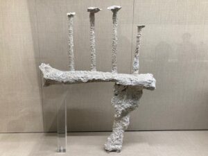
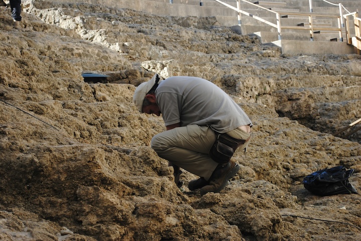
Even as Pompeii hosts its many visiting tourists, archaeological conservation and excavation work continues in the ancient city. These workers were oblivious to our presence as we passed them along the ancient street.
_________________________________________
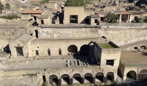
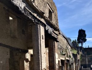
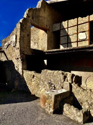
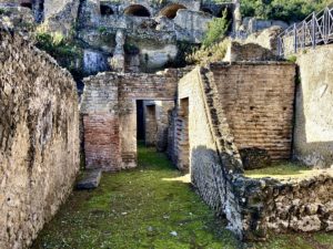
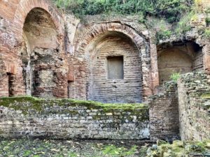
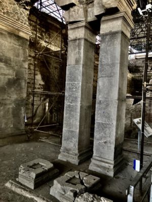
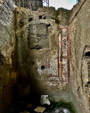
Herculaneum
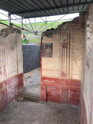
One cannot speak of Pompeii in the context of the 79 AD Vesuvius eruption without speaking of Herculaneum. Like Pompeii anciently, it bore the brunt of the cataclysm. I arrived at Herculaneum in the morning, embarking on a half-day’s worth of exploring the site. Given the size of the site compared to Pompeii, the stay was proportional, but experiencing the remains here was every bit as spectacular, if not more. An obvious difference between Pompeii and Herculaneum can be seen in the generally well-preserved height of the structures, as well as much of the restored decor within the structures. If one wants to see architecture and art more akin to the way it actually appeared before the eruption, Herculaneum earns first place. The incredibly well-preserved structures and their decorative elements reveal a rich tapestry of the physical appearance and lives of the citizenry.
_______________________________________
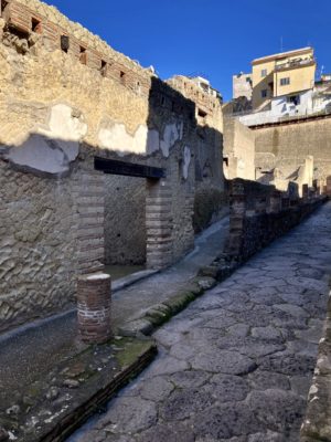
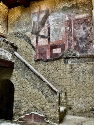
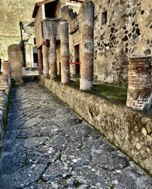
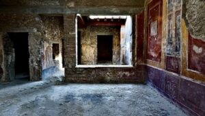
Above and below: Views of Herculaneum.
_______________________________________

_______________________________________

_______________________________________
_______________________________________

_______________________________________
_______________________________________
_______________________________________
Note the carbonized wooden beam exposed in this structure along Herculaneum’s decumanus maximus (central main street).
_______________________________________
_______________________________________
_______________________________________

_______________________________________
This marks the ancient shoreline at Herculaneum during the time of the Vesuvius eruption.
_______________________________________

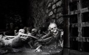
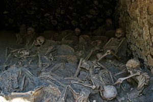
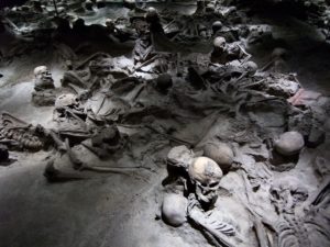
One example of the skeletal remains discovered at Herculaneum, preserving the final moment of life during the eruption.
_______________________________________
Baia
Be wealthy, and visit any of today’s most luxurious, seaside spa resorts designed for relaxation and fun in the sun, and you would get a modern-day taste of what defined the ancient site of Baia in its 1st Century A.D. heyday, nestled on the shore of the Gulf of Pozzuoli (part of the Gulf of Naples). This was a destination of choice for ancient Rome’s rich and famous. For centuries, Roman emperors and the Roman elite established opulent getaway villas here. While it drew people for the healing powers of its mineral springs and the soothing fragrance of the surrounding myrtle groves, it also became known for the hedonistic lifestyle of its residents, both permanent and transient. Its spas and baths drew everyone who was anyone, and stories of corruption and scandal is said to have marked its character, whether true or false. Only a fraction of its sumptuous massive architecture has been exposed. Its remains cascade down the steep rocky slopes that overlook the gulf. The numerous baths and complexes that functioned in their time were fed by the natural hot springs as well as fresh water transported in by the nearby Augustan aquaduct. Unlike the better known iconic sites of nearby Pompeii and Herculaneum, it is not on everyone’s must-see bucket list. But the fact remains that what any visitor can see here is every bit as impressive and engaging.
________________________________________
Above and below: Views of Baia.
________________________________________
________________________________________
________________________________________
________________________________________

________________________________________
________________________________________
________________________________________

________________________________________
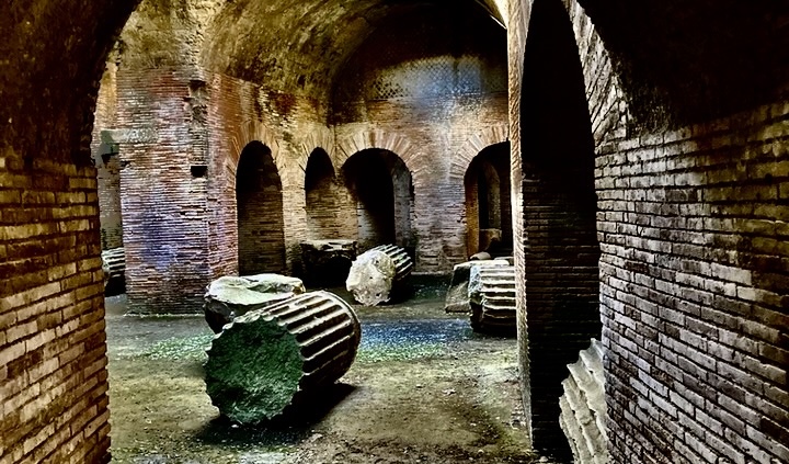
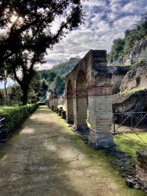
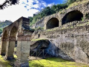
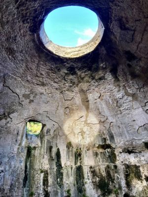
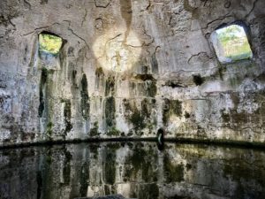
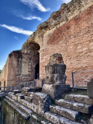
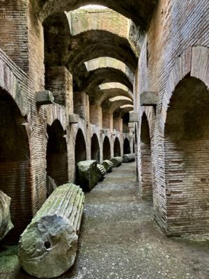
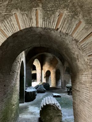
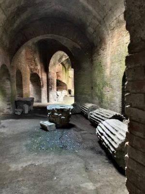
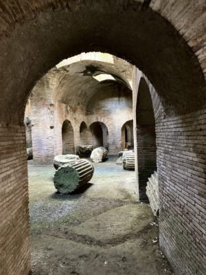
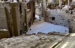
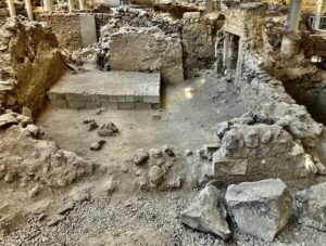
Pozzuoli
Imagine yourself as a member of the Roman Senate vacationing at your summer villa at Baia and you have plans for some exciting entertainment. Gladiatorial combat is a favorite of yours, so you have your horses harnessed to get yourself and your guests off to the games at the nearby Flavian amphitheater in Puteoli (today known as Pozzuoli).
One of the grandest amphitheaters of ancient Rome, the Flavian amphitheater of Pozzuoli is considered the third largest after the Colosseum in Rome and the Amphitheater of Capua. With a historic capacity of 50,000 spectators, it measures 482 x 384 feet, with the arena floor alone at 237 x 139 feet. One is impressed first by the exterior remains towering above, reddish brickwork providing a contrast with other grey-hued structural elements. Stepping down into its subterranean spaces, one enters a world unto itself, a massive system of arches, chambers, walls and fallen pillars, left as if the ancient inhabitants had just abandoned the spaces only the day before. It was difficult to believe the almost pristine freshness of the stone and brickwork. Hidden, protected from the ravages of human activity and weathering above ground level over the centuries, it seemed, like Pompeii and Herculaneum, frozen in time. One could still easily imagine the sight and sounds of the sets, animals, and other equipment and devices in play within the cool spaces, now mostly empty, as workers made preparations for the pending performance. In my mind’s ear, a somewhat muted ancient roar of the sitting crowds above could be heard.
____________________________________
Above and below: Views of the amphitheater at Pozzuoli.
____________________________________

____________________________________
____________________________________
____________________________________
____________________________________
____________________________________
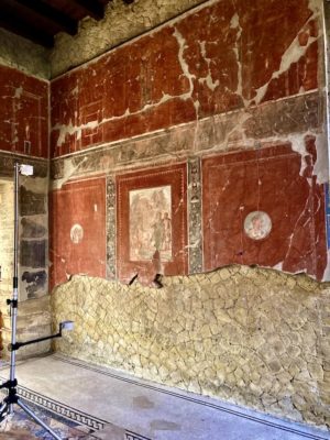
The Roman Villa of Positano
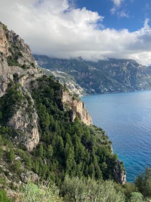
The Amalfi coast, named after the town of Amalfi on the Sorento Peninsula, is famously known for its majestically scenic beauty. Nick-named the “Divine Coast” and historically a popular destination for Europe’s jet set, it is no wonder that it is among the most visited regions of Italy, particularly during the high tourist season between April and October. Rugged, rocky vertical lines and cliffs, dressed by nature’s artful touch of green pine and other flora, overlook the vast, glistening blue water of the Mediterranean. To negotiate it, one must drive the winding and relatively narrow 25-mile-long Amalfi Drive that hugs the steep coastline from the town of Vietri sul Mare in the east to Positano in the west. For this writer, the drive was a bit like being in a visual heaven, but this was secondary to my objective — the Roman Villa of Positano.
Otium
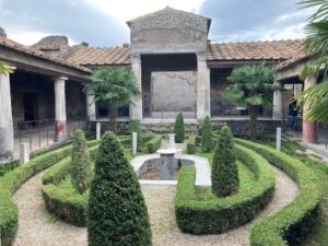
“Otium,” is a latin term which in ancient Roman times meant ‘leisure time’, a luxury of the Roman elite, who had their sumptuous seaside villas built along what is presently the Amalfi coast beginning as early as the Julio-Claudian Dynasty (27 BC to 68 AD). This was where the rich and famous played, away from the usual business of Rome and other urban centers. Evidence for one of these otium villas, today called the Roman Villa of Positano, was first discovered by Karl Weber, the initial excavator of Pompeii and Herculaneum, in 1758. But the most extensive excavations were undertaken between 2003 and 2016, when archaeologists uncovered a startlingly well-preserved portion of the villa beneath the medieval hypogeum of the Santa Maria Assunta church at the city center. Although it represented but a fraction of the original structure, the room, determined by the archaeologists to be a triclinium, featured walls covered with masterfully rendered fine fresco paintings in brilliant color and clarity, almost as if they had been painted yesterday. “Yesterday”, in this instance was a time not long after 62 AD, when an earthquake’s destruction presented the opportunity for the villa’s ownership to renovate, including this triclinium now on view to the public. Scholars have suggested that the villa may have been owned by Posides Claudi Caesaris, a wealthy and powerful man who, once a slave or servant, had been favored and freed by Emperor Claudius himself. It is thought that Positano may have taken its name from this individual. What can be seen today of Posides’s grand villa is its appearance just moments before it was buried beneath the same ash, pumice, and pyroclastic flows that destroyed Pompeii and Herculaneum in 79 AD. Archaeologists and scholars suggest that the greater complex featured at least a peristyle with a central garden and fountain, along with the triclinium and bath quarters — features typical of a Roman villa of the times.
Unlike Pompeii, Herculaneum, and other sites such as Stabiae, the Roman Villa of Positano afforded me the opportunity to see something “off the radar” of most visitors who come to see the most iconic spots in Campania.
______________________________________
The rugged and beautiful Amalfi coastline.
______________________________________
Above and below: Views of the wall painting in the Villa of Positano. The two lower photos show painting features displacement caused by the ancient earthquake.
______________________________________

______________________________________

_________________________________
Digging on the Dark Side
Somma Vesuviana, Italy
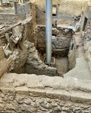
By any measure, this appeared to be the most massive ancient villa I had ever seen. Walls towered over me. Peering upward, I stretched my neck to observe their height — at least what was left of their full dimension after their destruction 1600 years ago. Metal scaffolding enveloped them and an enormous metal roof occupied space far above them, shielding them from the sun, wind, rain and other elements of the world outside. I was looking up from deep below ground surface. In contrast to the warmth of the sun’s radiation at ground level above me, the air was cool within this gargantuan, carefully and painstakingly excavated pit and I needed no hat to shield my head and face from the sun’s rays above.
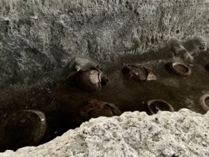
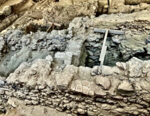
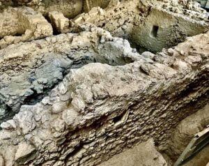
Located near the small town of Somma Vesuviana at the foot of the northern slope of Vesuvius (opposite and invisible from ancient Pompeii and Herculaneum and referenced by some as the ‘dark side’ of Vesuvius), this site was initially discovered in the 1930’s with limited excavation. But the most extensive investigation began in 2002 through a multidisciplinary project with the University of Tokyo. Those excavations, now ongoing, have revealed the walls preserved to a remarkable height, doorways decorated with Dionysiac motifs, a pilastered arcade, apses and interior room walls decorated with frescoes, cisterns, terraces, colonnades — emblematic of spaces created to impress large public audiences — and a large wine cellar with dolia (large earthenware jars), some of which can be seen still buried to their lips in the ground. Scholars have determined that they still contained fermenting grape juice when the eruption occurred. For a time, this was clearly more than a wealthy person’s villa — it was also a production facility for wine, the principal product of the region. Many artifacts, including a marble statue of Dionysus, the god of wine himself, were also recovered in the process. But what we see today is but a fraction of the entire complex that once existed.
The site, known today as the “Villa of Augustus”, or the Dionysiac Villa, is thought to have been first constructed in the 1st or 2nd century AD. Early on, scholars suggested it was a great villa of Augustus Caesar himself (and thus the name), and some have even suggested that Augustus died here, as it is recorded that he died near Nola, which lies not far from Somma Vesuviana. This is under scholarly debate to this day. It’s easy to assume that, like so many other ancient Roman structures in the Vesuvius area, it was destroyed and submerged in the ash from the famous 79 AD eruption — the one that destroyed yet ironically preserved the sensational remains of Pompeii, Herculaneum, and other nearby sites so popular for tourists today. But archaeological investigations have revealed little evidence and effects of the 79 AD eruption at this site. Archaeologists state that the remains we now see of the villa were likely constructed after the 79 AD eruption, in place of whatever was destroyed by that eruption. Unlike the structures of the doomed and lost cities of Pompeii and Herculaneum, this villa, situated by contrast at the north face of Vesuvius, in fact stood and operated for hundreds of years following the Plinian event. This was a great palatial villa that stood at the time of much later eruptions, most notable that of 472 AD (the eruptive material of which lies directly over the structure) and other events that followed, such as the 512, 536 and 1631 AD eruption events.
Research has shown that the area surrounding this side of Vesuvius and the villa continued to be robustly productive agriculturally after the 79 AD event, especially in the form of vineyards and the production of wine. The villa reflects this.
“The main room has many representations of grape bunches, and the stuccoed doorway is decorated with symbols of Dionysus, mystic rituals of his cult, and satyrs and maenads as his companions,” writes The Apolline Project: Illuminating the Dark Side of Vesuvius, a web-based summary report on the recent excavations at the villa. “A marble statue of Dionysus himself – represented as a young boy holding a panther cub in his arms – was originally placed in a niche, where it remained even when the entire building was transformed into a unit for agricultural production. During this transformation, a wine cellar was added to the lower terrace; we can take this as a sign of cultural continuity, despite the significant changes that occurred in religious beliefs and economy in the wider area.”*
Walking among the massive remains, I snapped a photo of a column of great pillars on one side of me. High walls ran perpendicularly at either end of the row of columns. They were adorned with niches that contained and framed at least one statue of Dionysus himself. I could see just below me on the opposite side, another terrace. Here, large, complete vessels lay mostly buried beneath soil. They were filled now with ancient volcanic material, but at one time they contained fermenting grapes. This was the wine cellar. Above this a towering wall of hardened pyroclastic ash and other volcanic material, cut meticulously and painstakingly by teams of archaeologists and other workers, illustrated an impressive record of layer upon layer of successive phases of multiple eruptions over centuries. Eventually, even this volcanic wall will be dug away, revealing what lies beyond and beneath — and what new insights on life in the aftermath of the 79 AD eruption will tell us.
___________________________________
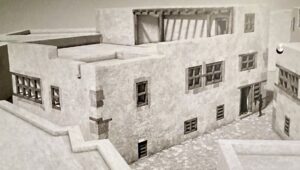
The Dionysiac Villa (Villa of Augustus): Pictorial
Above and two images below: At first blush, looking down from near the surface as one enters the excavated remains from above.
_______________________________________
_______________________________________
_______________________________________
_______________________________________
_______________________________________
_______________________________________
_______________________________________
Note the remarkably well preserved wall fresco painting in the back.
_______________________________________
The wine cellar.
_______________________________________
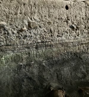
The layers of volcanic material that covered and encased the site exposed.
_______________________________________
Cisterns
_______________________________________
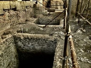
Pilastered arcade remains, cisterns below to the right.
_______________________________________
Massive pillars supported the internal structure of the audience hall.
_______________________________________
_______________________________________
Above and below: Apse, with decorative fresco painting still visible.
_______________________________________
_______________________________________
_______________________________________
_______________________________________
_______________________________________
_______________________________________
*https://www.apollineproject.org/somma.html
______________________________________
Museums
Any archaeologically-oriented visit would not be complete without including visits to key museums. This is where one can see, close-at-hand, some of the most important and/or most spectacular or diagnostic individual artifacts unearthed at the sites explored. In my case, there were museums attached to or related to most of the sites encountered during my visit, perhaps the most iconic of which was the famous National Archaeological Museum in Naples. Here, for example, the curators have displayed some of the most magnificent fresco paintings and other works of art and artifacts of Pompeii, among other sites. Here they are kept safe, preserved from the deleterious effects of the exterior environment, and close-at-hand for further study and conservation — and, of course, as a convenient one-stop destination for the public to see some of the most impressive objects representing the archaeology and ancient culture of the region.
For this author, the museum that left the most positive impression was unequivocally the facility attached to the site of Herculaneum. Small in comparison to the National Archaeological Museum of Naples, it is nonetheless rich with some of the finest artifacts and art pieces archaeologists have unearthed since the inception of investigations at the site. Furniture, tableware, jewelry, fresco paintings — all of the items that tell the story of Roman life in this coastal city for both the rich and the not-quite-so-rich, including a remarkably well-preserved boat recovered from the deposits that defined the ancient Herculaneum coastline when Vesuvius made its disastrous assault — make this museum something not to miss on any itinerary that includes Herculaneum.
______________________________
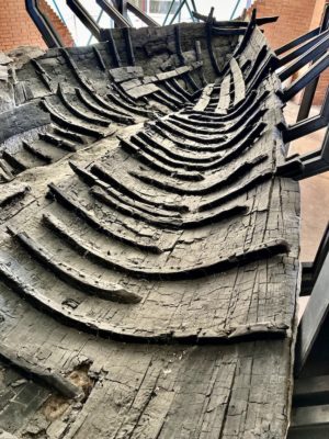
Above and below: Artifacts recovered from the Herculaneum excavations, as exhibited in the associated museum. Shown above is a well-preserved boat.
_______________________________________

_______________________________

_______________________________
_______________________________
_______________________________
_______________________________
The Death Chambers of Herculaneum
No one knows her name.
The hollow cavities that once held her eyes in her last, terrifying, desperate moment of life nearly 2,000 years ago stared back at me in silence. Surrounded by the articulated skeletal remains of family and friends, her bones told a story of a catastrophe that still echoes across time to this day. I was peering into a cave-like construction that once housed fishing equipment — one among 12 of them — neatly arranged as built in a straight-line row along the back perimeter of what is today a flat but stoney surface. It defined the dimensions of what was once an ancient city’s inviting seaside beach……………
Cataclysm
Autumn, 79 AD.
That was when Mount Vesuvius, only 8 miles to the northeast and an imposing daily presence as viewed unobstructed by any person from the city’s streets, spewed an explosive assault on the upscale Roman community of Herculaneum. A series of preceding earth tremors and volcanic rumblings must have given many in the city fair warning and time to escape. However, beginning around 1:00 pm, the volcano emitted clouds of volcanic material thousands of meters into the sky, eventually forming a column that flattened near the top between 17 and 21 miles high, forming what Pliny the Younger described in his letter to Tacitus as the overall shape of a familiar Italian Umbrella Pine tree. Atmospheric winds at first blew the cloud material to the southeast, falling mostly in the direction of Pompeii and surrounding communities. Roofs collapsed in Pompeii under falling debris, but Herculaneum’s initial experience was different.
“The cloud was being blown toward the south,” explains John Shepherd, a British archaeologist who has studied and shown groups through Pompeii and throughout the Campanian region for years. “Herculaneum was just on the edge of that cloud, so just a small amount of lapilli accumulated here over approximately 18 hours, giving most people in Herculaneum sufficient time to escape, but also giving people a false sense of security — the reason why so many took shelter in the [boathouse] shelters [along Herculaneum’s ancient shoreline].”
______________________________
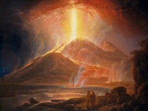
The Vesuvius Eruption. Painting by Jacob More (1740 – 1793), Public domain
______________________________
______________________________
But what appeared to be Herculaneum’s light and easy fate was not to last. By 1:00 am the next morning, the volcano’s massive eruptive column, like the twin towers in New York City on 9/11, began collapsing on itself, propelling a pyroclastic surge of ash and hot gases down the mountain and through the (now) mostly evacuated city at approximately 100 mph. The thunderous sound must have been terrifying for those remaining within earshot. One can only imagine the terror. Even in Misenum, across the Bay from Herculaneum and 5 miles farther from the erupting cataclysm, reactions were palpable. “We could hear women shrieking, children crying and men shouting,” writes Pliny the Younger. “Some were calling for their parents, their children, or their wives, and trying to recognize them by their voices [as darkness fell from the ash cloud]. Some people were so frightened of dying that they actually prayed for death. Many begged for the help of the gods, but even more imagined that there were no gods left and that the last eternal night had fallen on the world.”*
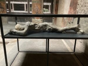
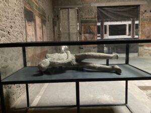
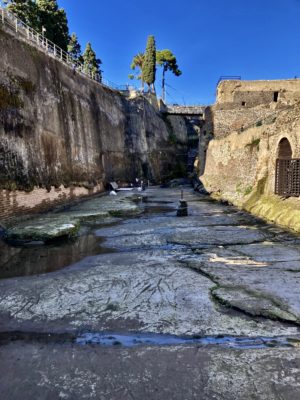
Many or most of the individuals and families who remained or lingered in Herculaneum, for whatever reasons, fled to the beach, where they had anticipated their escape by boats stored or docked near the boathouses, and by any additional efforts dispatched from nearby Misenum across the Bay. Possibly at least some of the remaining citizens on the beachfront were also simply the last in a long line or throng of people who early on had been escaping by boat dispatch over the past 18- 20 hours since the eruption began. Clinging desperately to hope, they had no idea they were facing their last moments of life. At least 350 people were left to their demise on the beach in that horrific event.
In the end, a total of six flows and surges eventually buried the city to a depth of approximately 20 meters, or over 65 feet. By the time most of those flows occurred, everyone who remained in or near the city had already perished. As witnessed today by the results of years of painstaking archaeological excavation, there appeared to be little relative destruction in many areas, preserving structures, objects and victims to a remarkable degree. However, other areas suffered significant damage, felling or erasing walls, and destroying columns and other objects.
Huddled Terror
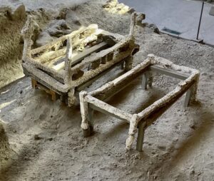
For almost 2,000 years Herculaneum was lost, hidden under 65 feet of hardened volcanic fallout. It was not until the early 18th century when evidence, in the form of statuary dug from work related to wells, began to emerge as a result of excavation. Excavations continued sporadically until the first and most significant, systematic, large-scale excavations were conducted under Italian archaeologist Amedeo Maiuri from 1927 until 1942. That project uncovered approximately four hectares of the ancient city, the results of which show most of what visitors can see today.
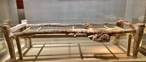
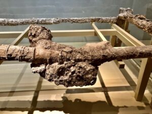
The excavations also revealed a scarcity of victims. That is, until 1980, when archaeologists began to uncover skeletal remains in excavations along what was once the ancient shoreline, particularly within the remains of chambered structures the Romans had constructed to house fishing equipment along the shore. Work conducted in the early 1980’s and then in the 1990’s eventually uncovered hundreds of mostly articulated skeletons. It would show, after pain-staking excavation, a macabre and horrifying scene. Mostly women and children had been found huddled closely together within the boathouse chambers, capturing what appeared to be moments of desperate refuge within dark, confined spaces. But skeletal remains of men were also found laid out on the ancient beach area itself, including the much-publicized remains of a man interpreted by some scholars to have been a high-ranking Roman soldier who was part of Pliny the Elder’s naval rescue mission dispatched to save fleeing citizens of the city. Hs body was found face down, with remnants of armor, a saddlebag, a backpack containing carpenter’s tools, and a leather belt embellished with silver and gold foil, attached to which was also a decorated sword with an ivory handle. Near the body archaeologists found a dagger, a stack of 12 silver and two gold coins, and the remains of a boat (now housed in the Herculaneum museum). Forensic analysis indicated he was a man between 40 and 45 years old, healthy and had led a physically active life.
His efforts clearly proved futile. If he was attempting to help the hapless refugees huddled within the boathouses, it was too late. The first and deadliest pyroclastic surge made sure of that.
________________________________
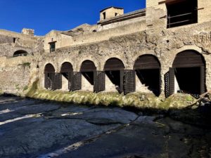
Above: The ‘boathouses’ along the ancient Herculaneum seashore.
________________________________
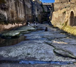
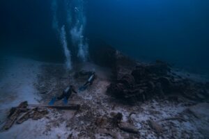
The ancient Herculaneum beachfront, where current excavations are taking place.
________________________________
In the Blink of an Eye
Walking first through a tunnel, one of the first things I encountered when I approached ancient Herculaneum were the well-preserved remains of the12 boathouse structures, all aligned in a row, flanking both the left and the right as I entered and passed over a low-lying bridge, like crossing a castle drawbridge into the city. Looking closer at these boathouse structures, however, I could clearly see articulated skeletal remains within, scores of them, bunched together within the chambers, places that were normally used to store nets and fishing gear. This is where I met her staring back at me, like a ghost from the past. Now only a caste replica of the bones she left behind, I knew there was a lost, untold history and personality here that will never be known to today’s living generations.
At least for now, we know how she died, and how quickly………
Through research conducted by a number of researchers, including a team under the leadership of Pierpaolo Petrone* of the University Federico II in Naples, scientists have analyzed the skeletal remains of the victims. This research was built upon and confirmed results of previous bioarchaeological and taphonomic studies. Based on the previous studies and their knowledge of how extreme heat can effect the human body, they formulated a horrific and vividly graphic hypothesis for study: The first pyroclastic surge of superheated ash and gases moved rapidly over the victims at a temperature of approximately 500 degrees Celsius, equivalent to 932 degrees Fahrenheit. This was hot enough to instantly boil and vaporize blood and all soft tissue, causing many skulls to explode and teeth to break, and muscular contraction of hands, feet and essentially whole bodies. Death was instantaneous, occurring before anyone could even react defensively to the impact of the surge. The effect was the same for both victims located outside and inside the boathouse chambers. Ash quickly filled the cavities left by vaporized tissue, explaining why archaeologists uncovered skulls that were filled with hardened ash. The enveloping ash bed laid down by the surge cooled and hardened, encasing the victims in the positions and postures they assumed only a second before instantaneous death. What archaeologists encountered during excavation was the victims’ final second of life before death, frozen in time for nearly 2,000 years before discovery.
Recent studies have now confirmed the temperature of the deadly surge by conducting macroscopic analysis, optical microscopy, histochemistry and electron microscopy on bone samples of the victims from the sites most affected by the Vesuvius eruption. By comparing the data drawn from the ancient bone samples to that of modern bone samples subjected to high heat testing in the laboratory, they concluded that the ancient victims indeed experienced a rapid temperature elevation to about 500 degrees Celsius (932 degrees Fahrenheit at Herculaneum, 600 degrees Celsius (1,112 degrees Fahrenheit) in nearby Oplontis, and 250 – 300 degrees Celsius (482 – 572 degrees Fahrenheit) in Pompeii, each 6, 7, and 10 kilometers (3.7, 4.4, and 6.2 miles) from Vesuvius respectively. They further concluded that victims located within 10 to 20 kilometers from Vesuvius were also killed instantly from surge effects.
The most recent, 2018 study by Petrone* and colleagues provided additional evidence confirming the effects of the surge on the Herculaneum’s beach refugees and others found present on the beach front during flight and rescue efforts. Applying taphonomic and other laboratory investigation procedures on skeletal samples, his team found clear cut skull cracking similar to that observed with cremated remains, as well as skulls filled with ash which produced hardened ash castes of the cranial interior contours, suggesting that the surge was hot and fluid enough to fill intracranial cavities very soon after soft tissues had disappeared. Moreover, they observed a presence of a red mineral residue encrusting the bones and penetrating the cranial ash fills as well as the ash bed surrounding the skeletal remains. Mass spectrometry analysis revealed the red mineral substance as high in iron, suggesting it originated from body fluids — another sign pointing to rapid vaporization of body fluids and soft tissues due to exposure to extreme heat conditions.
Thus, though the horrific fear, struggle and desperation of residents in the erupting volcano’s vicinity endured for hours, it can now be conclusively stated that actual death came in a fraction of a second, hardly enough time to know ‘what hit them’, so to speak. Death was ironically merciful. But the emotional suffering of family and friends who must have mourned their loved ones, their bodies missing, unaccounted for beneath the massive, hardened ash layers, would no doubt have persisted long after their demise. No burials, no epitaphs or evidence to mark the physical presence of their remains would bear record of their passing for nearly 2,000 years. But now their remains, as finally revealed through archaeological investigations, will likely serve as a lasting memorial, though their identities remain sadly nameless.
_________________________________
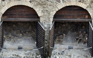
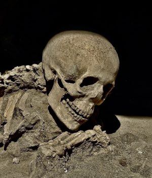
The skeletal remains of the victims within the ‘boathouse’ chambers can be clearly seen as one approaches Herculaneum from the ancient beachfront side. Public Domain, Wikimedia Commons
__________________________________________
__________________________________________
__________________________________________
__________________________________________
__________________________________________
Research and analysis on the remains continue. DNA testing and analysis will have more to say in the future. Just recently, for example, scientists have successfully sequenced the entire genome from an individual who died in Pompeii during the 79 AD eruption. Analysis showed that the individual was a male between 35 and 40 years old, may have suffered from tuberculosis, and had a DNA profile that was most similar to people living in central Italy today. And scholars and scientists alike await further future results from DNA studies of the victims at Herculaneum.
Petrone writes* about the future implication of the findings for today’s world —though the great eruptive events of Vesuvius are a matter of written and geologic history, the volcano and its surrounding geological environment are still very much alive. I sojourned the Vesuvius area only months before I penned this account for publication. As I traveled the region near the Bay of Naples, I could see hypothermal activity and fumaroles at a safe distance. I awoke to an earth tremor one morning. I had to remind myself that Vesuvius is still an active threat to all who walk in its shadow. In 79 AD, there were tens of thousands of people living daily lives in its vicinity.
Today there are three million.
___________________________________________
*https://igppweb.ucsd.edu/~gabi/sio15/lectures/volcanoes/pliny.html
*Petrone, Pierpaolo, The Herculaneum victims of the 79 AD eruption: a review, Journal of Anthropological Sciences, Vol. 97 (2019), pp. 68 – 89.
**Bioarchaeological and palaeogenomic portrait of two Pompeians that died during the eruption of Vesuvius in 79 AD, Scientific Reports, 26-May-2022.
_________________________________
The Masters of Akrotiri
Standing and peering out from here, I could easily see why people the world over flock to this destination. Far below me lay what appeared to be a vast, lustrous blue Mediterranean inlet. In fact, it is a massive, ancient water-filled caldera — the result of multiple past volcanic eruptions. This is what makes Fira, Greece’s sunny, bustling Santorini tourist town, a magnet for Europe’s honeymooners and vacationing couples. Behind me I could hear throngs of them walking the strand that hugs the great caldera’s high ledge. They are here to shop the countless pricey boutiques that line the strand — jewelry, clothing, souvenirs, everything money can buy. Some of them are wearing the clothes they purchased in these shops just yesterday. Many of them, however, are either unaware or uninterested in arguably the most valuable asset this popular resort island has to offer: its past.
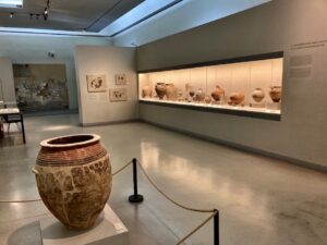
Just a short walking distance from where I stood, one of the world’s most prolific collections of ancient Aegean artifacts is displayed. Built in the early 70’s on the site of the earthquake-destroyed Ypapanti Church, the Museum of Prehistoric Thera stands almost unnoticed within a well-appointed gated space. Though almost lost among the commercial bustle that surrounds it, here is housed a time capsule of human habitation and life that flourished as much as over 5,000 years ago.
And even before.
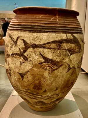
One exhibit near the museum entrance features fossilized flora recorded in the walls of the ancient caldera, echoing a 60,000-year-old ecosystem with a Mediterranean climate not unlike today’s climate on Santorini (known anciently as Thera). Beyond this, the spaces reveal a rich Late Neolithic and Bronze Age history of human occupation, with the most prolific exhibits showcasing the great 17th century BC florescence of the remarkable Minoan civilization that dominated the island at that time. The urban settlement of Akrotiri, the archaeological remains of which Santorini is best known and from which most of the artifacts exhibited in the museum were excavated, represents one of archaeology’s most spectacular discoveries, second only to Italy’s Pompeii and Herculaneum for the wealth and preservation of the material culture ancient people have left behind……
__________________________________
View of the caldera from modern day Fira on Santorini.
__________________________________
The Museum of Prehistoric Thera
__________________________________
A view of the interior of the Museum of Prehistoric Thera
__________________________________
Fossilized leaves of the olive tree from the walls of the caldera, dated to 60,000 BP.
__________________________________
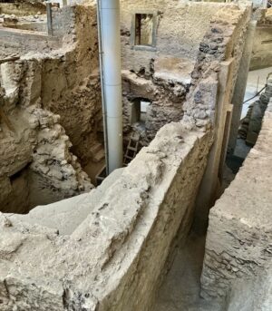
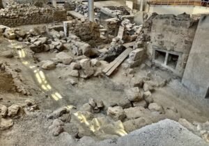
The Wonder of Akrotiri
For the people who went about their routine and peaceful daily lives in the island city of Akrotiri between 1609 and 1560 BCE, signs of the nearby volcano’s coming fury must have been noticeable for days. Earth tremors and tell-tale vapor-like plumes at its summit sounded the alarm, giving them time to quickly gather their most precious and necessary belongings and family members and make their way to the boats. As a maritime society where fishing, an aquatic industry and seagoing trade defined their lives, the technology and resources for evacuation were probably at hand.
Archaeologists can paint such a picture of a society prepared to escape the loss of life characteristic of such a disaster, as excavations of the city’s remains yielded little or no skeletal remains which would evidence a population caught and perished in the great cataclysm that was the eruption of the Thera volcano — one of the largest volcanic events of human history. It is said to have ejected up to four times as much material as the famous eruption of Krakatoa in 1883, destroying all indigenous life on the island. Its effect was experienced across the globe, its plume and volcanic lightning possibly described in the Egyptian Tempest Stele, and the Bamboo Annals of ancient China reporting rare yellow skies and summer frost during the Shang dynasty — clear signs of a volcanic winter.
Though largely abandoned by the time Thera released its first explosive bellow, Akrotiri’s pre-eruption structural face was transformed in the fiery onslaught. Yet, like ancient Rome’s Pompeii and Herculaneum below the pyroclastic expulsion of Mount Vesuvius in 79 AD, Thera’s ejecta and ash produced a remarkable result — an ancient city much destroyed yet miraculously well enough preserved to create a stunningly detailed time capsule of life and advanced human achievement more than 3,500 years old.
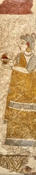
Extensive excavations beginning in 1967 by archaeologist Spyridon Marinatos and his team uncovered a remarkably advanced urban settlement, with multi-storied buildings, paved streets, evidence of fine furniture, various religious and domestic vessels, magnificent fresco wall paintings, an elaborate and advanced drainage system, and much more. Like Pompeii and Herculaneum, Akrotiri proved to be one of the most spectacular archaeological sites ever uncovered. Of all the objects and features of the ancient city discovered, however, no other Bronze Age site in the world could compare to Akrotiri in terms of the early advanced works of distinctive fresco painting produced by its master artists — the most prolific collection of such paintings preceding the great fresco works of the masters of ancient Rome and Renaissance Italy much later.
___________________________________
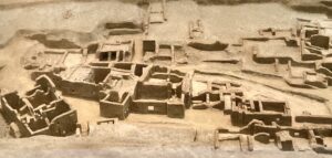
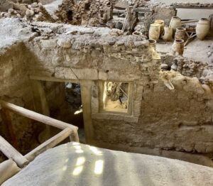
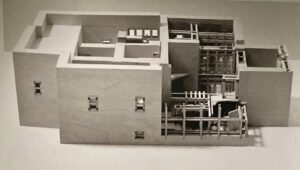
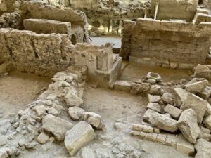
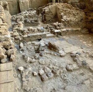
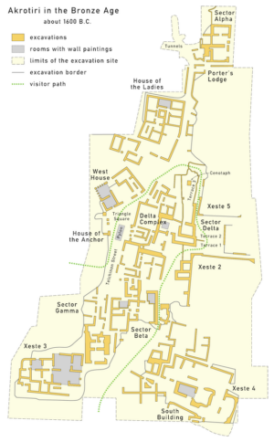
Aerial view of the central area of the Akrotiri excavation site (model as exhibited within the Museum of Prehistoric Thera).
___________________________________
Akrotiri: “Triangle Square”, shows the height at which the structures at Akrotiri were preserved from the volcanic eruption. See below for additional examples of site preservation.
___________________________________
“Millhouse Square”
___________________________________
“Pithoi Room”
___________________________________
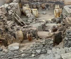
“Pithoi Room”
___________________________________
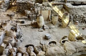
“Pithoi Room”
___________________________________
___________________________________
Plaster cast of a carved wooden table.
___________________________________
Plaster cast of a portion of a chair.
___________________________________
Basket impression
___________________________________
Above and below: Amazingly well preserved furnishings.
___________________________________
___________________________________
___________________________________
___________________________________
 The Paintings of Akrotiri
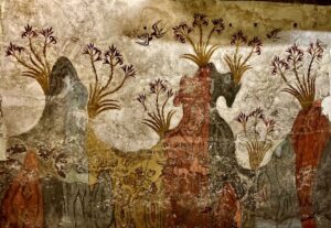
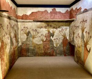
The excavations at Akrotiri have informed a picture of public and religiously significant buildings and other structures adorned with masterfully created fresco paintings that reflected, for this time in ancient history, a unique, avant-garde style. They have marked the Minoans as a standout in this way among ancient populations, particularly during the 17th century BC. Moreover, of all the Minoan settlements that have been excavated, Akrotiri has yielded the best preserved paintings recovered in situ from the walls of its structures……….
Xeste 3
Located south within the excavation area, a large structure (the second largest excavated at Akrotiri) was found to contain the largest assemblage of wall paintings, and is distinct from all other structures in that it housed a lustral basin. In Minoan palaces such as that found at Knossos on Crete, lustral basins were sunken rooms that are thought to have been used either for ritual purification, or as bathrooms. This multi-storey building featured stone benches, a grand staircase, and 15 rooms. The rooms were connected with multiple pier-and-door partitions/doorways that permitted flexibility and adaptability to be interconnected or shut off when necessary. Archaeologists believe, based on the findings, that the building was used for public ceremonies and ritual activity. The rooms as well as the grand staircase were adorned with wall paintings.
______________________________________
Artist rendering of Xeste 3, as presented at the Museum of Prehistoric Thera
______________________________________
Above and below: Excavated remains of Xeste 3.
__________________________________

__________________________________
__________________________________
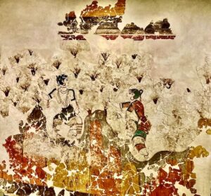
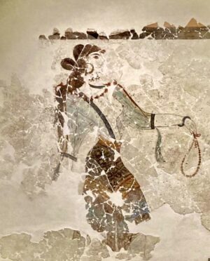
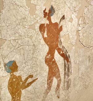
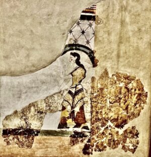
Above and below: Xeste 3, Room 3, 1st Floor: Females gathering crocus flowers, then offering their stigmas to the Godess of Nature through the intervention of a monkey.
__________________________________
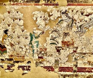
__________________________________
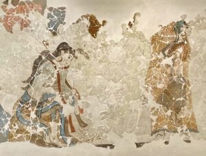
Above and below: Xeste 3, Room 3, Ground Floor: Painted above the Lustral Basin, three females perform a ritual involving crocus plants on the Theran landscape.
__________________________________
__________________________________
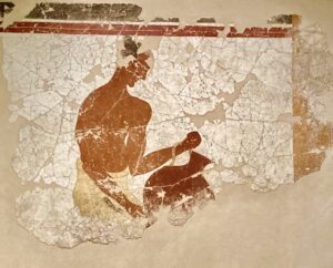
Above and below: Xeste 3, Room 3 Ground Floor: Male figures performing a rite of passage ceremony.
__________________________________
__________________________________
__________________________________
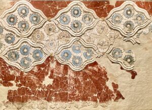
Xeste 3: Wall painting with relief ornaments and painted rosettes: From a room on the second story
__________________________________
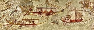
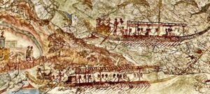
The West House
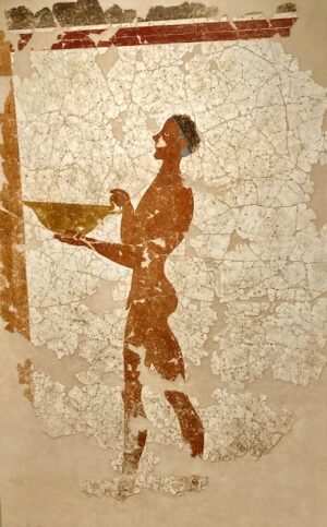
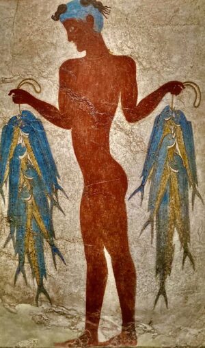
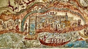
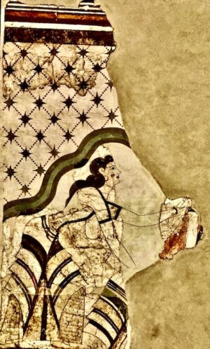
Located in the west central part of the excavation site, the structure designated as the “West House” by archaeologists contained some of the best known, best preserved wall paintings. The house was long and relatively narrow, consisting of a ground floor, first floor, second floor and main staircase that gave access to each storey. The ground floor featured storerooms, workshops, a kitchen and a mill-installation. The first floor had storage rooms, a lavatory, two rooms featuring magnificent mural paintings, and a large chamber dedicated to weaving. The upper floor also contained rooms. The notable wall paintings found in the West House include two frescoes of fishermen, or youth fishers, a fresco of a female holding a vessel, interpreted as a priestess, and a magnificent miniature frieze depicting what is interpreted to be a flotilla, illustrating a major overseas voyage of a fleet visiting several harbors and towns.
____________________________________
Artist’s conception of the West House, as exhibited at the Museum of Prehistoric Thera.
____________________________________
Above and below: Excavated remains of the West House.
_________________________________
_________________________________
Above and below: Fishers as displayed in West House.
_________________________________

_________________________________
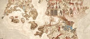
A partial frieze, a portion of which may be illustrating a naval battle.
_________________________________
Above and below: Paintings depicting the chambers of a ship.
_________________________________
_________________________________
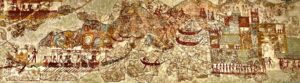
Above and below: Frieze illustrating the adventures and explorations of early Aegean seafarers.
_________________________________
_________________________________
_________________________________
_________________________________
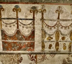
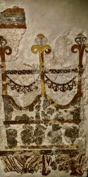
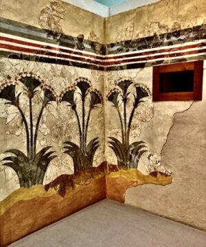
The House of the Ladies
Located in the northwest section of the site, the “House of the Ladies” is a large, multi-storey building thought to be the house of an upper class family. It was named after the wall fresco of the ladies and papyrus plants that decorated the interior of one of the rooms. The structure is thought to have once been a three-storey house with as many as 10 rooms on each floor, but extensive destruction of the north end of the building has created uncertainty.
___________________________________
Above and below: Excavated remains of the House of the Ladies
___________________________________
________________________________
Above and below: The wall paintings from the House of the Ladies.
________________________________
________________________________
________________________________
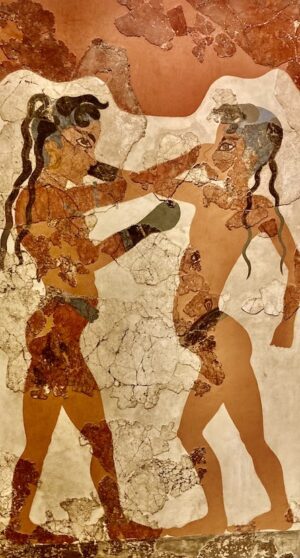
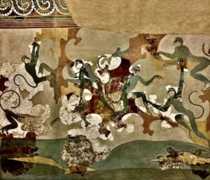
Sector Beta
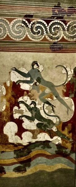
Situated in the south central area of the site, two attached buildings featured three of the most notable frescoes of Akrotiri. The first floor of the western building was adorned with two wall paintings, the Antelopes and the Boxing Boys. The eastern building featured the large, avant-garde composition called “Fresco of the Monkeys”, showing monkeys climbing over a rocky landscape at the side of a river.
____________________________________

____________________________________
_________________________________
_________________________________
_________________________________
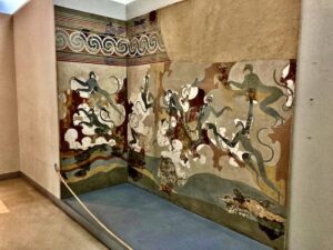
The wall paintings of the monkeys as they would have related in situ in sector B structure room (As displayed in the Museum of Prehistoric Thera).
_________________________________
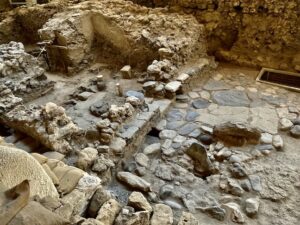
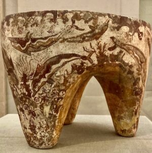
Complex Delta
Occupying a central position in the city is the Complex Delta, which actually comprises four structures or buildings, each crowned above the entrance with double horns of consecration. Mud flow from the eruption inundated the rooms, yet preserved in situ one of Akrotiri’s most famous artworks, the Spring Fresco, in one of the rooms. Also preserved were imprints of wooden vessels and furniture, seen today as plaster casts. Other finds included tablets of the Linear A script and numerous examples of imported pottery, precious stone and bronze objects.
____________________________________
Above and below: Excavated remains of Complex Delta.
____________________________________

_________________________________
_________________________________
_________________________________
Above: Spring Fresco detail. Below: Spring Fresco in its entirety as exhibited at the National Archaeology Museum of Athens
_________________________________
_________________________________
Creating the Art
Much of the style and iconography of the Theran wall paintings were clearly derived from those seen on Crete, where the greater part of Minoan civilization flourished. This included the common tripartite organization of the wall compositions, females represented in white flesh and males in brown, and themes including natural world elements and ritualistic, productive human activity. Although the artists drew from centuries-old Cycladic tradition in art creation, most of the Theran artists trended toward the avant-garde in their representations, a characteristic that set them apart from other artistic traditions and achievements of the time.
As to the process of creating the paintings, the artists applied a mixed technique of buon fresco, applying pigments to wet plaster, and fresco secco, applying pigments to dried plaster.
The paintings were created in four successive phases:
- Wall surfaces were first smoothed with a layer of mixed mortar and straw. Over this, they applied a layer of lime plaster (stucco) about 1 to 2.5 cm thick, then a layer or two of fine stucco.
- While the stucco was still wet, a taught, fine string was stretched/pressed into the stucco to create three horizontal physical divides in the wall composition. Wall paintings on Thera were typically divided into three zones in this way.
- The artist would render a sketching of the subject(s) by incising or light washing the lies into the stucco. This guided the actual painting onto the still-wet stucco/plaster, where the colors were absorbed into the plaster itself. Smaller details were then added often after the stucco had dried.
- The palette of colors used were largely the same as that used by the Minoans on Crete: the background white of the stucco, earth pigments for black, red and yellow from hematite and yellow ochre, and Egyptian blue, imported from Egypt, and/or glaucophane. The painting was then enriched with different tones, including colors such as rose, pale pink, reddish brown, and dark brown. To achieve these variations, the artist combined pigments or mixed them in lime water.
____________________________________
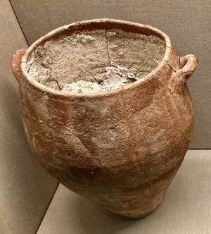
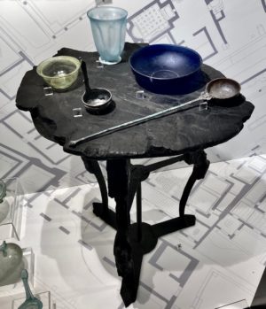
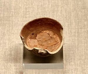
Pithos containing lime-plaster. Above and below artifacts excavated at Akrotiri.
____________________________________
Semiglobular cup containing red pigment
____________________________________
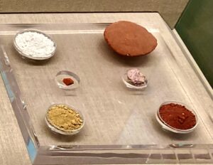
Pigments and lime
____________________________________
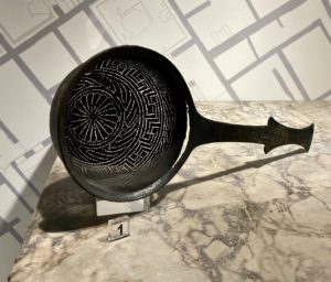
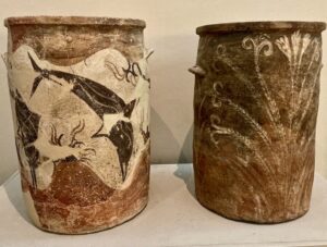
Paintings and painting techniques were not exclusive to walls. Here, for example, is a Minoan offering table excavated at Akrotiri, showing use of painting to illustrate ceramic ware with scenes and subjects from their natural surroundings. Ceramic ware pieces below indicate the same trend or style of painting throughout the culture at Akrotiri.
____________________________________
____________________________________

____________________________________
____________________________________
A Theran Diaspora?
Though the distinctive Minoan style of wall painting can be said to be a regional phenomenon (e.g., Thera and Crete), in recent years archaeologists have found evidence of its presence in other parts of the Mediterranean. Were the art masters of Thera known and in employment demand among the palace, temple, and wealthy elites throughout the Bronze Age Old World trade network? Or did the artist refugees of the great Thera eruption find their way to other parts of the known world to ply their trade and perhaps even to settle?
The Canaanite site of Tel Kabri in present-day northwest Israel, for example, could hold clues to answers. The author spoke with the George Washington University’s Dr. Eric H. Cline in Washington, D.C. in May of 2011. Cline had already been co-director of the excavations at Kabri for years at that point.*
“Kabri, which is a Canaanite palace,” said Cline, “has Minoan wall and floor paintings in it…… We already knew about this site because Kabri had been excavated before by [Aharon] Kempinski and [Wolf-Dietrich] Niemeier from 1986 to 1993, and they found a painted floor and about 2,000 fragments of painted plaster.”
There are several things that strongly suggest the paintings were Minoan or Cycladic in style, according to Cline.
“One is this whole technique of painting on the plaster wall while it is still wet,” continues Cline. “That is an Aegean technique. In the Near East, they more often painted after the plaster was dry. Second, there is a technique of using strings to help in the painting process. For example, the Minoans took a string and just tightened it so that it contacted the wet plaster and created a perfectly straight line. We have plaster at Kabri that shows that. The other thing they did was take string and dip it in, for example, red paint, and tighten it quickly against the plaster. The red paint thus makes a perfectly straight line. That is how the floor at Kabri was created. That is a Minoan technique.”
Moreover, the painted subject matter appears to match the subject elements typically depicted in wall paintings such as those found at Akrotiri on Thera and Knossos on Crete, says Cline, such as certain plant and flower types, the ships, and architecture.
Were they works produced by Theran artisans who were displaced by the great Theran eruption? Possibly, says Cline, But he emphasizes that this is purely speculative.
Were they evidence of new, permanent Minoan settlers at Kabri? Possibly, says Cline. But likely not for long. Cline summarizes his view on this question:
“There is no evidence so far that Minoans, or any other Aegean people, such as those in the Cyclades or mainland Greece, migrated to and settled at Kabri as a group. We don’t have enough Minoan pottery to support that. I suspect that, yes, the eruption at Santorini may have caused a migration of people from the island, including artisans who may have painted at Akrotiri or Knossos and were in need of employment, staying at Kabri temporarily. Certainly the paintings at Kabri look an awful lot like the ones on Santorini [ancient Thera]. So it may have been a refugee situation, but that would be mere speculation. The one thing we can support right now is that, if there was a group of Aegean people at Kabri, they were only living there temporarily.”
At least three other places or excavation sites in the eastern Mediterranean have evidenced painting like that found at Akrotiri. One is Tel Dab’a in Egypt, another in Turkey at Alalakh, and finally at Qatna in Syria, currently being excavated by a German/Italian/Syrian team.
Married to the Sea
As I found myself hiking along the edge of Santorini’s great caldera and gazing out and down at ocean water where, anciently in some places dry land existed, I could not help but think about the ancient landscape, and the people who once thrived here over 3600 years ago.
Though the written records of Akrotiri — as they were created on clay tablets in Linear A, a yet undeciphered script — have offered few clues to this ancient society, the artifacts, structures, and paintings revealed by the excavations have provided a rare window on the lives of this ancient people: We know they were advanced in the sense that they lived in multistoried buildings with sophisticated drainage and water distribution systems, indoor bathrooms, lustral basins for ritual practice, and apartments and rooms designed for flexible and adaptable use. Though they practiced agriculture, they were most of all a maritime people, whose economy flourished on extensive trade with other civilizations in and around the Mediterranean, such as Minoan Crete, Mainland Greece, Egypt, Cyprus, and the Levant. Pottery imports and other artifacts, as well as their wall paintings depicting ships, testify to this. This therefore was a people who were enriched through trade. Its position on an island that occupied a strategic position between Cyprus and the Levant to the east, Crete and Egypt to its south, and mainland Greece to its north, made sure of that. Its people wore fine clothing. Artifacts and structures evidenced a well-developed textile industry. The beautifully-clad women appeared to have been revered and, indeed, occupied an important and even elevated position in its culture and religious practices, even in the form of deities. Their culture and way of life was deeply defined by their religion. In addition, they loved and esteemed their natural environment, as clearly demonstrated by their art. Above all, the masterful paintings have given the world an almost intimate and stylistic window on the minds of the Akrotirian inhabitants.
Walking among the remains of Akrotiri, I marveled at how the 3,600-year-old shroud of its volcanic ash and debris was painstakingly removed many years ago by teams of archaeologists and their volunteers. Today the city stands silent and empty, at least the small portion that has been thus far revealed — a shadow of a once bustling community. Only the mind’s eye can now fill these streets with life. But subtle clues in its remains tell us they were a people likely much like us.
Perhaps more than we might imagine.
_______________________________


