A new open-access database has revealed 483 Bronze Age settlements in western Anatolia – an area long treated as a blank spot on the archaeological map. This unprecedented overview illuminates the cultural landscape around Troy and challenges long-standing Eurocentric assumptions. Together, these findings help redraw the political and economic geography of the Late Bronze Age.
For a combination of historical and disciplinary reasons, leading voices in Mediterranean archaeology have – at times deliberately, at times inadvertently – overlooked an important independent cultural sphere. This observation lies at the heart of, and ultimately motivated, the creation of the private foundation Luwian Studies in 2014.
In western Türkiye (aka Asia Minor or Anatolia) – across from Greece, in the region that encompasses Troy and the later classical cities of Ephesus, Pergamon, and Miletus – there once flourished a Bronze Age cultural landscape distinct from both Mycenaean Greece to the west and Hittite Anatolia to the east. Its achievements include a suite of Indo-European and Anatolian languages, foremost among them Luwian, as well as a unique writing system that endured for more than a millennium: the Luwian hieroglyphs.
____________________________

A map of the cultural zones traditionally identified in the northeastern Mediterranean leaves western Asia Minor conspicuously blank – even though this region includes renowned sites such as Troy and is rich in natural resources (Luwian Studies #0109).
____________________________
Because this cultural sphere has remained largely neglected, Mediterranean archaeology has long struggled with a series of fundamental questions it has been unable to resolve. Among them: Who were the Sea Peoples? What triggered the sudden fall of the Hittite Empire? Was there a Trojan War? And how did the far-reaching collapse at the end of the Bronze Age unfold?
Although the proposition – derived from theoretical considerations – that an independent Luwian cultural sphere once existed in what is now western Türkiye was formulated more than three decades ago, it has only now gained a solid empirical foundation. A new publication, “An interoperable catalogue of Middle and Late Bronze Age settlements in western Anatolia (c. 2000–1200 BCE),” has just appeared in Nature Scientific Data. In it, archaeologists, geologists and geodata specialists present a publicly accessible database identifying 483 major settlements dating to the Middle and Late Bronze Age in western Anatolia, west of an imagined Eskişehir–Antalya line. This resource makes the entire state of archaeological knowledge in the region available to researchers and the broader public worldwide.
Greece, on the western shore of the Aegean Sea, has been a field of intensive archaeological exploration since the first systematic excavations in Olympia (1875) and Mycenae (1876). Although the archaeological significance of the cities along the eastern Aegean coast is well known from prominent excavations at classical sites, the level of cultural development in the preceding Late Bronze Age has never been systematically charted. This absence is not accidental. For more than a century, the statutes of the German Archaeological Institute prevented it from working outside the Greco-Roman cultural sphere. The underlying aim was to provide a politically fragmented Europe with an ideologically unified, Eurocentric foundation by amassing comprehensive knowledge of – and often idealizing – the achievements of classical antiquity. The educational reforms initiated by Wilhelm von Humboldt in the 1820s pursued the same goal and ultimately cemented it. As a result, Eurocentrism has become so deeply ingrained in archaeological research that it has long since been internalized and rarely questioned.
Yet the need for this ideology has long since faded. What has not happened, however, is a fundamental revision of textbooks or prevailing scholarly opinions – simply because the necessary factual basis was missing. For roughly 150 years, research focused overwhelmingly on Greco-Roman antiquity, leaving little room for alternative cultural narratives. In such circumstances, where could a broader body of knowledge have come from?
It was for this reason that, as early as 2011, we began assembling a catalogue of archaeological sites beyond the traditional Greek sphere of influence – on the eastern side of the Aegean. Excavations had been carried out there as well, though not in comparable numbers, and a number of archaeological surface surveys had taken place. We systematically evaluated both: 33 excavations and 33 surveys, which together produced 445 scientific publications, most of them written in Turkish. By now making this bibliography available, these works – many of which were previously difficult for non-Turkish speakers to access – now enter the international conversation for the first time.
____________________________

Relief map of western Türkiye showing 33 excavated Bronze Age sites (white dots), 483 known settlement locations (black dots), and the areas covered by 33 archaeological surveys (Luwian Studies #0102).
____________________________
With meticulous attention to detail, archaeologist Serdal Mutlu systematically reviewed these publications to identify and catalog sites that were inhabited between 2000 and 1200 BCE – that is, during the Middle and Late Bronze Age. His work culminated in a 2016 catalogue of 340 sites, initially compiled in a locally stored Excel file. The dataset was later broadened to its present total of 483 settlements, informed both by geospatial analyses that aided in identifying additional sites and by Alper Aşınmaz’s systematic evaluation of relevant online databases.
To be included in the catalogue, now called LuwianSiteAtlas, a site had to meet a series of clearly defined criteria. It needed, among other things, a minimum diameter of 100 meters – large enough to constitute at least a village settlement with several hundred inhabitants. A single farmstead, by contrast, would not qualify. Moreover, the site had to show continuous occupation throughout the second millennium BCE, possess a discernible toponym, and be precisely locatable by geographic coordinates.
By making the material available as an online database, archaeological research in western Asia Minor is advancing not only epistemologically but also methodologically. We migrated the dataset from flat spreadsheets into a relational MySQL database. Clearly defined entities – settlements, time periods, attributes, toponyms, and bibliography – are now structured for rapid and flexible queries. Through a structured ETL (extract–transform–load) workflow, duplicates were removed, terminology was standardized, and all coordinates were cross-checked against published reports to ensure referential integrity.
__________________________

The LuwianSiteMap allows users to focus on specific regions or data categories, such as settlement types or chronological phases (Luwian Studies #0243).
__________________________
The site catalogue is thus no longer a private working list but a fully public resource, accessible online and – even on the go – via smartphone. An interactive map, the LuwianSiteMap, allows visitors to filter by site type, period, or region; navigate to individual settlement pages; and export search results as CSV or JSON files for further analysis. The platform is optimized for both desktop and mobile use and relies on open-source web-mapping libraries, keeping the learning curve shallow even for non-specialists.
What “483 Sites” Really Means
To assess how readily the sites in our study area – roughly the size of Germany (c. 373,000 km²) – can be detected on vertical aerial imagery, we searched for each location in Google Earth’s multitemporal satellite archive. Approximately 80% of the sites reported in the literature could already be identified directly on the satellite images. Over the course of more than a decade of fieldwork, we also visited the majority of these locations and documented them photographically.
The catalogue is comprehensive, but not exhaustive. Since systematic surface surveys were introduced in the 1980s, roughly half of western Anatolia has been surveyed – albeit with varying intensity. Much of the remaining terrain consists of steep rocky landscapes or densely forested areas. Even so, it is reasonable to assume that the actual number of Bronze Age settlements was at least twice as high as the number documented today. Some sites will have been eroded beyond recognition; others lie buried beneath alluvial deposits in major floodplains.
The resulting LuwianSiteMap displays more than simple points on a screen. Users can select among five different base maps – ranging from satellite imagery to road and relief maps – making the logic behind ancient settlement choices immediately apparent. The availability of fertile farmland was a decisive factor in choosing a place to settle. Communities typically avoided the floodplains themselves, establishing villages instead on slightly elevated ground at their margins – close to reliable water sources yet safely above seasonal inundation. Hilltops were selected where they commanded strategic passes, and such vantage points were often fortified. Along major trade routes, settlements appear at roughly 17-kilometer intervals, approximating a day’s travel. On the coast, they align with natural harbors, while locations where several geographic advantages coincided developed into regional trading hubs.
_______________________________

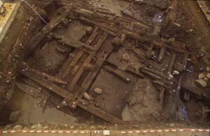
Seyitömer Höyük is a typical Luwian settlement – fully excavated only because the site had to be cleared for coal mining (© Turkish Ministry of Culture and Tourism, General Directorate of Cultural Heritage and Museums, Department of Excavations and Research; Luwian Studies #0255).
_______________________________
The map also features a dynamic chronological table that displays the time spans of the sites visible in any chosen view. When zoomed out, broader patterns and regional trends emerge at once. The tool can measure distances and areas within seconds, allowing users to trace corridors between plains and uplands or to sketch the probable extent of an ancient city with ease.
Another strength of the online atlas lies in its integration with external resources. From any site description, users can jump directly to linked entries in Pleiades, Wikidata, iDAI.gazetteer, GeoNames, Nomisma, and related repositories. Cross-platform comparisons become possible with a single click.
Behind this capability sits a considerable technological infrastructure – which we need not unpack in full here (involving Python scripts, API queries, URIs, and RDF data built on standards such as CIDOC-CRM and Dublin Core, all running on a virtual server). What matters for users is the practical result: a network of machine-readable links that connect settlements, periods, and cultural contexts in a consistent, interoperable structure.
LuwianSiteAtlas is licensed for public use under Creative Commons Attribution 4.0. The dataset is also archived in an open repository (Zenodo), where it can be queried, filtered, and downloaded – allowing others to extend the catalogue, test its assumptions, or adapt the workflow for their own research needs. Since the public version of the database was introduced in November 2024, the platform has been migrated to a virtual server and integrated more deeply into the Semantic Web. In practice, this means richer machine-readable relationships between settlements, time spans, and cultural horizons; the ability to run queries across multiple repositories; and smoother interoperability with digital-humanities tools. For users, the benefits translate into clearer connections, faster exports, and more intelligent searches. For research, the effect is cumulative: formerly isolated datasets can now communicate with one another.
_______________________________
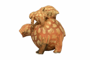
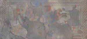
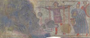
A remarkable vessel from Seyitömer Höyük reflects the distinctive artistic traditions of the Luwian cultural sphere (© Turkish Ministry of Culture and Tourism, General Directorate of Cultural Heritage and Museums, Department of Excavations and Research; Luwian Studies #0256).
_______________________________
What is the practical value of having such an online database? Until now, the political geography of western Anatolia in the Late Bronze Age has been viewed largely through the lens of Hittite imperial policy, simply because most of what we know derives from the archives of the Hittite capital at Hattusa (modern Boğazkale). More than 33,000 documents and fragments, largely written in Akkadian cuneiform, have been recovered from its libraries. These texts speak, for example, of confrontations with Ahhiyawa and Millawanda, and countless scholarly studies have examined these sources in detail.
This elevated, text-driven perspective – essentially the view from the Hittite court – can now be complemented by evidence for the actual economic and spatial organization of the region. We can examine how large a settlement’s catchment area was, how densely its networks were structured, and how closely communities clustered around critical mineral resources. The capacity to study these relationships on a regional scale is entirely new for western Anatolia. And because the data can be exported cleanly into GIS, anyone can conduct their own cluster analyses, proximity studies, or route models to explore how topography and water corridors guided the movement of goods – whether between inland plains and coastal ports or along the foothills linking one valley system to the next.
LuwianSiteAtlas thus provides solid empirical support for the thesis that an independent cultural sphere once existed in western Asia Minor – namely the Luwian culture. The region long remained a blank space on the archaeological map partly because Sir Arthur Evans, the founder of Aegean prehistory, declined to place Troy within its broader regional context when publishing his work on the excavations at Knossos in the 1920s. At a time when Greece and the newly founded Turkish Republic were engaged in a bitter conflict over the legacy of the Ottoman Empire, Evans defined only the cultures situated on European soil – the Minoan, Mycenaean, and Cycladic – as relevant for future research. Troy and Hattusa were effectively left outside this framework. The political and ideological bias embedded in this early scholarly tradition continues to shape perceptions to this day.
____________________________
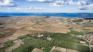
Despite generations of research at the citadel of Troy (in the foreground), the extensive Karamenderes floodplain directly beside it has never been examined archaeologically – a striking gap in our understanding of the site’s wider setting. (With kind permission of the Çanakkale Provincial Directorate of Culture and Tourism; Luwian Studies #2109).
____________________________

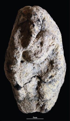
This fingernail-sized bronze seal is the only written document ever recovered from Bronze Age Troy. Inscribed with Luwian hieroglyphs, it provides a singular glimpse into the site’s broader cultural milieu. (Luwian Studies #0540).
____________________________
It was never a plausible assumption. Western Türkiye is richer in natural and strategic resources than any other region of the eastern Mediterranean. It offers exceptionally fertile farmland, extensive forests for timber, and some of the richest ore deposits of gold, silver, lead, and copper in the ancient world. Its perennial rivers carry more water than those of neighboring regions, and its coastline provides the greatest concentration of natural harbors. Land routes and waterways converge here, connecting three continents and four seas.
Literacy appeared in western Asia Minor earlier than in Greece and continued there uninterrupted while Greece remained without writing for four centuries during the Dark Ages. The Amarna letters of Pharaoh Akhenaten (c. 1351–1334 BC) contain no correspondence with Greek rulers, but they do include letters exchanged with the king of Arzawa in western Anatolia. Three of the Seven Wonders of the Ancient World were located in this region. Nearly all major Greek thinkers before Socrates hailed from western Asia Minor.
______________________________

Luwian hieroglyphic script was the third major writing system, after cuneiform and Egyptian hieroglyphs, to spread across the eastern Mediterranean. It was used from about 2000 to 700 BCE (Luwian Studies #0525)
______________________________

The Uluburun shipwreck – shown here in a reconstruction at the Museum of Underwater Archaeology in Bodrum – illuminates the commodities and international maritime routes that linked the Luwian coastal regions to the wider Bronze Age world (Luwian Studies #1600).
______________________________
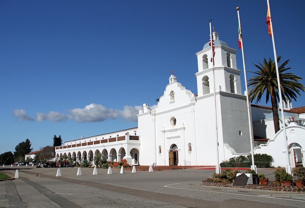
Powerful early states – such as the Lydian kingdom, which Herodotus, himself from this region and later praised by Cicero as the “father of historiography,” describes as surpassing all others – flourished here on a cultural substrate inherited from the Late Bronze Age. The same is true for the great Greek and Roman cities of Ephesus, Miletus, Pergamon, and many more.
For nearly three millennia, Troy occupied a central place in the European imagination. Cities were modeled on Troy; aristocratic lineages traced their descent to its royal house. Throughout the Middle Ages, for at least four hundred years, accounts of the Trojan War ranked among the most widely read works among Europe’s educated classes. Only after the fall of Constantinople in 1453 and the second Ottoman siege of Vienna in 1683 did pressure mount on Europe’s intellectual elites to construct a new worldview – one in which Ottoman culture and its predecessors were cast as the adversary. This shift laid the foundation for a Eurocentric ideology that continues to shape perceptions today.
If we wish to address the unresolved questions of Mediterranean archaeology outlined at the beginning, we must inevitably bring Troy and the culture of its surrounding regions – the Luwians – into our reconstructions. Once we do so, long-standing puzzles begin to fall into place: who the Sea Peoples were, why the Hittite kingdom collapsed, and whether there was, in fact, something akin to a Trojan War. With LuwianSiteAtlas, we have now taken a significant step toward answering these questions.
_____________________________
Scientific publication
Aşınmaz, Alper, Serdal Mutlu, and Eberhard Zangger. 2025. “An Interoperable Catalogue of Middle and Late Bronze Age Settlements in Western Anatolia (c. 2000–1200 BCE).” Nature Scientific Data, https://doi.org/10.1038/s41597-025-06241-9.
Launched in 2011, the project has been supported throughout by funding from Luwian Studies.