Archives

The Siege of Masada

Jodi Magness is the Kenan Distinguished Professor for Teaching Excellence in Early Judaism at the University of North Carolina at Chapel Hill. She previously taught at Tufts University. Professor Magness has more than 20 years of excavation experience, including the co-direction of excavations of the Masada Roman siege works and the Roman fort at Yotvata. She has authored numerous works, including Masada: From Jewish Revolt to Modern Myth, The Archaeology of Qumran and the Dead Sea Scrolls, and The Archaeology of the Early Islamic Settlement in Palestine.

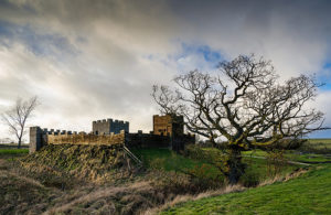
When the First [Jewish] Revolt erupted in 66 [AD], bands of Jewish rebels took over some of Herod the Great’s fortified palaces, which had been occupied and maintained by garrisons since the king’s death seventy years earlier. Three were still in Jewish hands after the revolt officially ended in 70: Herodium (near Bethlehem), Machaerus (to the east of the Dead Sea), and Masada. The Roman legate (governor) of the newly established province of Judea, Lucilius Bassus, set out to subdue these last holdouts. Limited information from Josephus and archaeological evidence suggest that Herodium was taken quickly. The rebels at Machaerus capitulated before the Romans commenced their assault, although Josephus describes skirmishes between the two sides. The Roman circumvallation (siege) wall and ten or eleven siege camps are still visible surrounding the base of Machaerus, as is a massive stone assault ramp that was never completed.

In 72 or 73, the Roman troops arrived at the foot of Masada, the last fortress held by Jewish rebels. In the meantime, Bassus had died and was replaced as legate by Flavius Silva:

In Judea, meanwhile, Bassus had died and been succeeded in the governorship by Flavius Silva, who, seeing the whole country now subjugated by the Roman arms, with the exception of one fortress still in revolt, concentrated all forces in the district and marched against it. This fortress was called Masada. (Josephus, War 7.252)

Silva was a native of Urbs Salvia in Italy, where two inscriptions have been discovered recording his dedication of an amphitheater in 81 or later, after he finished his term as legate of Judea.

The Roman campaign to Masada took place in the winter-spring of 72–73 or 73–74. Although today many visitors are under the impression that the fortress held out against the Romans for three years (after 70), the siege lasted no longer than six months and almost certainly was much shorter—perhaps as little as seven weeks from beginning to end.

The Roman Army

The Roman army was so effective because its soldiers were highly trained career professionals—mostly legionaries and auxiliaries—who enlisted for a lifetime of service. Legionaries were drafted from among Roman citizens and served primarily as heavy infantry. At the time of the siege of Masada, there were approximately thirty legions in the Roman army, each consisting of about five thousand soldiers. Auxiliaries were conscripted from among non-Roman citizens, who were awarded citizenship at the end of their term of service. Auxiliaries usually operated as light infantry, cavalry, and archers, that is, the more mobile troops who protected the flanks of the heavy infantry in battle. Auxiliary units were organized into regiments numbering five hundred or a thousand soldiers each.

Approximately eight thousand Roman troops participated in the siege of Masada: the Tenth Legion (Legio X Fretensis) and a number of auxiliary cohorts. The Tenth Legion, now under Silva’s command, had participated previously in the sieges at Gamla (or Gamala) (in the Golan), Jerusalem, and Machaerus. After the fall of Masada, the Tenth Legion was stationed in Jerusalem until circa 300, when the emperor Diocletian transferred it to Aila (modern Aqaba) on the Red Sea. Servants and slaves (including Jews), pack animals, and vendors accompanied the Roman troops at the siege of Masada.

The Roman Siege Camps

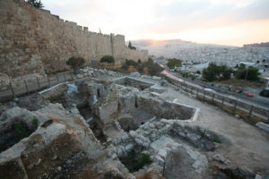
When the Romans arrived at the foot of Masada, they constructed a stone wall, 10–12 feet (ca. 3 meters) high and approximately 4,000 yards (4,500 meters) long, which completely encircled the base of the mountain. This circumvallation wall sealed off the fortress, preventing the besieged from escaping and making it impossible for others to join them. Gwyn Davies emphasizes “the clear symbolic message conveyed” by the construction of the siege works, both to the rebels holding out atop Masada and other peoples under Roman rule. Guards posted at towers along the wall kept watch to ensure that no one scaled it. In addition to the circumvallation wall, the Romans established eight camps to house their troops, which archaeologists have labeled with the letters A–H. The camps surround the base of the mountain, guarding potential routes of escape. Josephus’s description of the circumvallation wall and siege camps accords well with the archaeological remains:

The Roman general advanced at the head of his forces against Eleazar and his band of Sicarii who held Masada, and promptly making himself master of the whole district, established garrisons at the most suitable points, threw up a wall all round the fortress, to make it difficult for any of the besieged to escape, and posted sentinels to guard it. (War 7.275)

The sequence of camps begins with A at the foot of the Snake Path and proceeds counterclockwise: Camps A–C on the eastern side of the mountain; D at the northern tip; E–F on the northwest side; G to the southwest; and H perched atop Mount Eleazar to the south of Masada. The camps are connected by the circumvallation wall and by a path called the “runner’s path” which can still be hiked today. In an era before field telephones and walkie-talkies, the runner’s path was the line of communication, used by runners who carried Silva’s orders from camp to camp. The 1981 film Gallipoli directed by Peter Weir featured a young Mel Gibson in the role of an Australian runner in that famous World War I battle.

The layout of the siege camps at Masada reflects the efficient and standardized operating procedure of the Roman army. All of the camps are square or roughly square in shape, with the sides oriented to the four cardinal points. In the middle of each wall is a gate that led to two main roads running north-south and east-west, which intersected in the center of the camp. The units within each camp were laid out around these roads, with the most important units (such as the commander’s living quarters and the camp headquarters) in the center and other units farther away. Camp B on the east and Camp F on the northwest are conspicuously larger than the others, as they housed the legionary troops, while the other camps were occupied by auxiliary soldiers. Camp B served as the distribution point for supplies transported by boats from areas surrounding the Dead Sea, which were offloaded at a dock on the shore to the east of Masada. Camp F was positioned so Silva could oversee the construction of the assault ramp, as Josephus describes: “He himself [Silva] encamped at a spot which he selected as most convenient for siege operations, where the rocks of the fortress abutted on the adjacent mountain, although ill situated for commissariat purposes” (War 7.277).

A square walled area in the southwest corner of Camp F, called F2, postdates the fall of Masada. Camp F2 housed a small garrison that remained for a short period after the siege ended, until they ensured the area was completely subdued.

_________________________

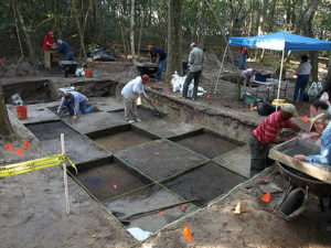
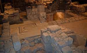
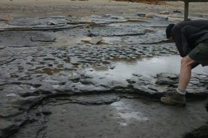
The 1995 Excavations in Camp F

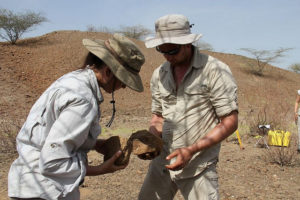
Although Yigael Yadin was a specialist in ancient warfare and served as chief of staff of the IDF [Israel Defense Forces], his excavations focused on the remains on Masada’s summit and largely ignored the Roman siege works. These remained virtually untouched until summer 1995, when I co-directed excavations in the siege works with three Israeli colleagues: Professor Gideon Foerster (at the Hebrew University of Jerusalem); Professor Haim Goldfus (now at Ben-Gurion University); and Mr. Benny Arubas (at the Hebrew University). We focused on Camp F as it is the better-preserved of the two legionary camps. Our excavations provide valuable information about Roman siege warfare in general and the fall of Masada in particular. The remains at Masada are arguably the best-preserved example of siege works anywhere in the Roman world, for two reasons: (1) they are constructed of stone, whereas in other parts of the Roman world siege works often were made of perishable materials such as wood and sod; and (2) because of their remote desert location, the Masada siege works have never been destroyed or built over. The circumvallation wall and camps are clearly visible today, evidenced by heaps of stones that can be seen from the top of the mountain. Although the camps appear barren and sterile, our excavations revealed that the units within them are filled with broken pottery and other artifacts.

The circumvallation wall and the walls of the camps are constructed of dry field stones, that is, unhewn stones collected from the rocky surface of the ground, with no mud or mortar binding. The outer walls of each camp originally stood to a height of 10–12 feet (ca. 3 meters), while the walls of the units inside the camps were about 3–4 feet high (ca. 1 meter). The latter were not actually walls; rather, they were bases or foundations for leather tents, which the Roman army pitched while on campaign in the field. We excavated several units inside Camp F, which consist of one or more rooms, with the interiors usually encircled by a low bench of dirt and stones. The benches were used both for sleeping and as dining couches. The praetorium—the living quarters of the commander, Silva—is located in the center of Camp F, by the intersection of the two main roads. Although most of the stones of the praetorium were removed for use in the construction of Camp F2, the discovery of luxury goods including imported glass vessels from Italy and eggshell-thin painted Nabataean pottery bowls confirm that this was indeed the commander’s living quarters. My personal favorite is a stump-based amphoriskos—a table jar—painted with ivy leaves, from which I like to imagine Silva’s servant poured his wine.

Next to the praetorium is a stone platform, which was a tribunal from which Silva could review and address his troops, who mustered in the open space around it. Nearby is a rectangular pi-shaped structure, oriented so that its narrow end opens toward Masada. This structure was stripped to the foundations when the wall of Camp F2 was constructed over it. Nevertheless, the plan and location indicate that it was a triclinium—the officers’ mess. Triclinium in Greek means “three couches,” referring to the arrangement of dining couches around three sides of a formal dining room. As the officers in this triclinium dined, they gazed out at the mountain of Masada.

Just inside the wall of Camp F2 and partly covered by it is the principia—the camp headquarters. Although the principia yielded almost no finds, it was the only unit we excavated with plastered walls and floors. Nearby and also within the walls of F2, we excavated a row of identical one-room units called contubernia. A contubernium was the smallest subdivision of a legion, consisting of eight enlisted men who marched and camped together on campaign. Each of these one-roomed units housed a group of eight men—a contubernium. The interior of the room was lined with a rough stone-and-dirt bench used for sleeping and dining. The contubernia are small because the men ate and slept in shifts, similar to living quarters in a modern submarine. In front of each room is a small open porch or courtyard enclosed by a wall, with a small hearth in the corner where the men prepared their food. Roman soldiers were equipped with mess kits which they used on campaign, as depicted on Trajan’s Column in Rome, where soldiers are setting out with their mess kits dangling from a pole slung over one shoulder.

The floors of the units we excavated in Camp F were covered with layers of broken pottery, mostly from storage jars. The rarity of cooking pots and dining dishes such as bowls and cups apparently is due to the use of mess kits by the enlisted men, whereas Silva and his officers were provided with fine ceramic and glass tableware. The storage jars, which have a bulky, bag-shaped body, are characteristic of Judea in the first century CE and presumably were produced for the Roman army by Jewish potters. The siege of Masada was a logistical challenge for the Romans due to the scarcity of food and water in the immediate vicinity. They had to import enough supplies every day to provision approximately eight thousand soldiers as well as pack animals, servants, and slaves. Food and water were hauled from great distances over land on pack animals or shipped on boats from points around the Dead Sea. Josephus describes the provisioning of the Roman troops at Masada: “For not only were supplies conveyed from a distance, entailing hard labor for the Jews told off for this duty, but even water had to be brought into the camp, there being no spring in the neighborhood” (War 7.278).

As Josephus indicates, Jewish slaves hauled the food and water. The supplies were transported in baskets and animal skins, which are lighter, easier to carry, and less susceptible to breakage than ceramic jars. Upon arrival at Masada, the contents of these containers were emptied into ceramic jars for storage. After the siege ended, the storage jars were emptied and left behind.

__________________________

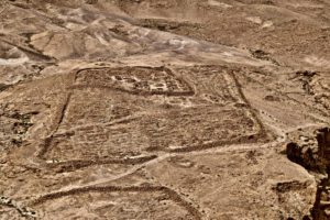
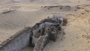
Roman siege camp F, showing the remains of the later camp F2 in the upper left corner inside the main camp.

__________________________

Roman Military Equipment

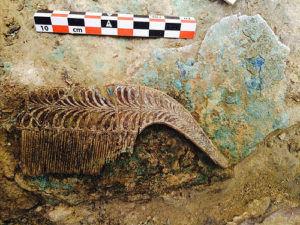
Not surprisingly, we found few remains of military equipment in our excavations in Camp F, as the soldiers took their weapons with them when the siege ended. However, in and around the tent units were piles of large, egg-shaped pebbles, which had been collected from wadis (river beds/washes) in the vicinity. They were used as slingshot stones and were left behind because they had no inherent value. In contrast to Camp F, Yadin’s excavations atop Masada yielded a large and diverse quantity of military equipment, which I co-published with Guy Stiebel. Yadin’s finds included hundreds of iron arrowheads, nearly all of which represent the standard Roman Imperial type: a head with three barbed wingtips to stick into the flesh, and a long tang that was inserted into a wooden or reed shaft. The arrows were fired in volleys by archers. Three bone ear laths from Yadin’s excavations come from the reinforced ends of composite bows. Yadin also discovered hundreds of small bronze scales, most of which are narrow and elongated, and have four holes at the top and a raised rib down the center. Originally the scales were sewn onto a cloth or leather backing so that they overlapped. In the first century CE, scale armor was typically worn by auxiliaries. One large group of scales was colored red, gold, and perhaps silver, and apparently belonged to a suit of parade armor.

Legionary soldiers wore segmented armor (lorica segmentata), which consisted of overlapping iron strips, a few fragments of which were found in Yadin’s excavations. The armor covered only the upper part of the body and was worn over a short tunic that stopped just above the knees. On their heads, legionaries wore a bronze helmet with large cheek-pieces attached to the sides; we discovered one such cheek-piece in Camp F. The typical footgear worn by Roman soldiers consisted of heavy hobnailed leather sandals called caligae, examples of which were preserved at Masada thanks to the arid desert atmosphere. The emperor Gaius was nicknamed Caligula—“little boots”—after the hobnailed sandals worn by the soldiers who he befriended as a child. The lower part of a legionary’s body was left unprotected by armor to allow for mobility.

Around their waists, legionaries wore a leather belt to which several items were attached. An apron consisting of narrow strips of leather with bronze studs dangled from the front of the belt, which protected the soldier’s genitals (as nothing was worn under a tunic) and made a clanking noise intended to frighten the enemy in battle. A leather sheath holding a dagger was attached to the right side of the belt, and on the left side was a leather sheath with a gladius—the double-edged sword used by legionaries. The tip of the sword sheath was reinforced with a bronze casing called a scabbard chape. Yadin found a complete scabbard chape with delicate cut-out designs, through which the dark leather sheath would have been visible. This scabbard chape, which must have belonged to a legionary officer, has parallels in Italy dating to the mid-first century CE. In the left hand, legionaries held a large rectangular shield to protect the unarmored lower part of the body. In the right hand, they carried a tall, skinny javelin called a pilum, which was the characteristic offensive weapon of legionaries. In battle, the pilum was thrust or thrown to pin the opponent, who was then killed with the sword in hand-to-hand combat.

The Assault Ramp

The Romans undertook the siege of Masada by constructing their camps and the circumvallation wall, thereby sealing off and isolating the mountain. In some sieges, no additional measures were required to starve an enemy into surrender. This was not the case at Masada, where the besieged were provisioned with large quantities of food and water stored in Herod’s palaces, whereas the Roman forces had to import supplies from long distances. Therefore, at Masada the Romans sought to bring the siege to a swift resolution. To accomplish this, they had to move their troops and siege machinery up the steep, rocky slopes of the mountain and break through Herod’s fortification wall at the top. There were two paths to the top of Masada: the Snake Path on the east and another path on the west (today buried under the Roman ramp). Using these paths would have required the soldiers to climb up in single file while carrying their personal equipment as well as the battering ram, which had to be erected at the top to break through the Herodian casemate wall—all the while leaving the soldiers vulnerable to stones, boulders, and other projectiles thrown or fired by the defenders above. To solve this problem, Silva ordered his men to construct an assault ramp of dirt and stones, which ascended to the summit from a low white hill (called the Leuke by Josephus) at the foot of the western side of the mountain:

The Roman general, having now completed his wall surrounding the whole exterior of the place, as we have already related, and taken the strictest precautions that none should escape, applied himself to the siege. He had discovered only one spot capable of supporting earthworks. For in rear of the tower which barred the road leading from the west to the palace and the ridge, was a projection of rock, of considerable breadth and jutting far out, but still three hundred cubits [1 cubit = ca. 1.5 feet or 0.5 meters] below the elevation of Masada; it was called Leuce. Silva, having accordingly ascended and occupied this eminence, ordered his troops to throw up an embankment. (Josephus, War 7.304–5)

Once completed, the ramp provided a gentle slope that the soldiers could ascend easily with several men across. At the top of the ramp, they erected a stone platform for the battering ram:

Working with a will and a multitude of hands, they raised a solid bank to the height of two hundred cubits. This, however, being still considered of insufficient stability and extent as an emplacement for the engines, on top of it was constructed a platform of great stones fitted closely together, fifty cubits broad and as many high. (Josephus, War 7.306–7)

During the siege operation, auxiliary troops provided cover fire with a barrage of arrows and ballista stones—large, round stones shot from torsion machines:

The engines in general were similarly constructed to those first devised by Vespasian and afterwards by Titus for their siege operations; in addition a sixty-cubit tower was constructed entirely cased in iron, from which the Romans by volleys of missiles from numerous quick-firers and ballistae quickly beat off the defenders on the ramparts and prevented them from showing themselves. (Josephus, War 7.308–9)

Yadin found iron arrowheads and ballista stones surrounding the area at the top of the ramp, confirming Josephus’s description of a concentrated barrage of cover fire. Andrew Holley, who published the ballista stones, notes that their relatively light weights (nearly all weighing less than 4 kg and most of these less than 1 kg) indicate they were fired from small-caliber engines and were aimed at human targets rather than being intended to make a breach in the casemate wall. Most of the ballista stones were discovered along the northwest edge of the mountain, facing the assault ramp, with large deposits in two casemate rooms (L1039 and L1045). Holley has argued persuasively against Ehud Netzer’s suggestion that these stones were associated with engines used by the Jewish rebels, as the Romans would not have established Camps E and F within range of artillery fire. Instead, the ballista stones in L1039 (the Casemate of the Scrolls) and L1045 were fired into the fortress by Roman artillery mounted in the tower on the assault ramp, and were collected and dumped in these rooms after the siege ended. The Casemate of the Scrolls also yielded rare fragments of Roman shields made of three layers of wood faced with glue-soaked fabric, which were covered with leather that still bears traces of red paint.

In the above passage, Josephus describes the Romans firing volleys of ballista stones and “missiles” to provide cover during the siege operation. And indeed, numerous ballista stones and iron arrowheads of the characteristic Roman barbed, trilobite type with a tang (which originally was set into a wooden or reed shaft) were discovered in Yadin’s excavations at Masada. Puzzlingly, however, there is not a single definite example of an iron projectile point (catapult bolt). Catapult bolts are heavier than arrowheads (which were shot from manual bows) and differ in having a solid head and a socket instead of a tang. In contrast, numerous iron projectile points were found at Gamla in contexts associated with the Roman siege of 67, where, according to Josephus, the Romans employed catapults.

In light of the absence of iron projectile points at Masada, Guy Stiebel and I originally proposed that catapults were not employed during the siege, perhaps due to the steep angle of projection from the ramp to the fortification wall. This would contradict Josephus’s account and suggest that his description of the artillery barrage was formulaic. However, I now believe that the archaeological evidence can be reconciled with Josephus’s testimony. As Gwyn Davies has observed, “It is inconceivable that the Romans didn’t have bolt-firers at the siege [of Masada]. In fact, the bolt-firers would almost certainly have been mounted in the siege tower for the purposes of sweeping the parapets, even if they were not advanced up the ramp when the tower was being winched up or emplaced at the foot of the ramp.” Davies suggests that the bolts were collected and recycled by the Romans in cleanup operations after the siege, just as the ballista stones were gathered and dumped.

Although it may be difficult to believe that the Romans were so thorough that they retrieved every iron bolt head in their cleanup operations, an examination of the distribution of iron arrowheads at Masada supports this possibility. The overwhelming majority of arrowheads come from the lower terrace of the northern palace and the workshop in the western palace. These spots were buried in collapse from conflagrations, and for this reason presumably were not retrieved by the Romans. Other locations with small groups of arrowheads are on the western side of the mountain, around the area that would have been swept by cover fire from the direction of the ramp. However, aside from the arrowheads in the northern palace and the western palace, which were buried in collapse, the Romans seem to have retrieved most of the arrowheads as well as all the iron bolt heads. The small groups of remaining arrowheads seem to have been left where they were gathered, perhaps because their poor condition rendered them unusable. And unlike Masada, the Romans did not occupy Gamla after the siege. Presumably they retrieved some of the iron bolt heads at Gamla, but without a garrison left to occupy and clear the site, the rest of the bolts remained among the destruction debris.

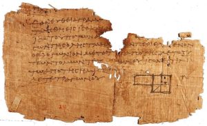
In addition to biblical and extra-biblical scrolls, the only examples of Latin papyri at Masada were discovered in the Casemate of the Scrolls. The Latin papyri either date to around the time of the siege or are associated with a detachment of legionaries that was stationed atop the mountain for up to several decades after the siege ended. One of the Latin papyri is inscribed with a line in hexametric verse from Virgil’s epic poem, the Aeneid (4.9). Another Latin papyrus—the longest one discovered at Masada—is a military “pay record.” This document records payments made by a legionary named C. Messius of Beirut, which were deducted from his salary for items such as barley and clothing. A third, poorly preserved Latin papyrus lists medical supplies for injured or ill Roman soldiers, specifically mentioning bandages and “eating oil.” In addition to the papyri, twenty-two ostraca (inscribed potsherds) inscribed in Latin with the names of Roman soldiers were found in the vicinity of the large bathhouse in the northern palace complex. The names—including Aemilius, Fabius, and Terentius—belong to legionaries and are unusual in that they are written on the inside rather than the outside of the potsherd.

During the 1995 excavations in the siege works, we cut a section through the ramp a little over halfway up, to determine how it was constructed. Today the ramp, which can still be climbed, appears to consist of fine, white chalky dust that poofs up in clouds underfoot, mixed with small to medium-sized stones. Our excavations revealed that the Romans constructed the ramp by taking pieces of wood—mostly tamarisk and date palm—and laying some of them flat and using others as vertical stakes to create a timber bracing filled with packed stones, rubble, and earth. Today the tips of timbers are visible protruding near the bottom of the ramp. Geological analyses suggest that the ramp was built on a natural spur that ascended the western side of the mountain from the Leuke, although we did not reach the spur in our excavations. Once the ramp was completed, the Romans erected a stone platform for the battering ram and began to break through Herod’s fortification wall. A large breach in the casemate wall at the top of the ramp is still visible today.

_________________________

The Last Stand

Josephus reports that once the Romans breached the wall, they found the rebels had constructed a second wall of wooden beams filled with earth, which not only withstood the battering ram but was compacted by its blows:

The Sicarii, however, had already hastily built up another wall inside, which was not likely to meet with a similar fate from the engines; for it was pliable and calculated to break the force of the impact, having been constructed as follows. Great beams were laid lengthwise and contiguous and joined at the extremities; of these there were two parallel rows a wall’s breadth apart, and the intermediate space was filled with earth. Further, to prevent the soil from dispersing as the mound rose, they clamped, by other transverse beams, those laid longitudinally. The work thus presented to the enemy the appearance of masonry, but the blows of the engine were weakened, battering upon a yielding material which, as it settled down under the concussion, they merely served to solidify. (War 7.311–14)

While preparing the final publication describing the architecture of Masada, Ehud Netzer noticed that only about 10 percent of the buildings on the mountain showed evidence of destruction by fire, and they were not contiguous. Netzer reasoned that had the buildings been set on fire, they all should have burned down. He proposed that the absence of burning in most of the buildings means their wooden ceiling beams were dismantled, presumably for the construction of the second wall as described by Josephus. If Netzer’s interpretation is correct, it would corroborate this part of Josephus’s testimony about the fall of Masada.

Once the Romans noticed that the rebels had constructed a second wall of wood and earth, Silva ordered his soldiers to set it on fire. At first, a strong wind blew the flames toward the Romans, threatening to burn down their battering ram. However, the wind suddenly changed course and blew back toward the wall, causing it to go up in flames. At this point, Josephus says, Eleazar ben Yair convened the men and convinced them to take their own lives to escape capture, thereby depriving the Romans of their victory:

Let our wives thus die undishonored, our children unacquainted with slavery; and when they are gone, let us render a generous service to each other, preserving our liberty as a noble winding-sheet. But first let us destroy our chattels and the fortress by fire … Our provisions only let us spare; for they will testify, when we are dead, that it was not want which subdued us, but that, in keeping with our initial resolve, we preferred death to slavery. (War 7.334–36)

___________________________

From MASADA: From Jewish Revolt to Modern Myth by Jodi Magness. Copyright © 2019 by Princeton University Press. Reprinted by permission. Footnotes originally included in the text have been excluded from this published excerpt.

Readers interested in reading much more about the fascinating story of Masada and its historical context can obtain author Jodi Magness’ new book from Princeton University Press

Early Settlement of the Sahara

Cameron M. Smith completed his undergraduate studies at London’s Institute of Archaeology and Durham University, learning paleoanthropology through two field seasons at Koobi Fora, Kenya. He went on to pursue his Ph.D. in archaeology at Simon Fraser University in Canada, specializing in stone tool analysis and continuing to excavate sites worldwide. Dr. Smith is now a faculty member at Portland State University, where he teaches courses in world prehistory and field and laboratory methods. His research interests include evolution, biocultural adaptation, cognitive evolution, and the archaeology of Pacific Northwest Coast. He has published widely in research journals including Antiquity, the American Journal of Physical Anthropology and the Journal of Field Archaeology. The Atlas of Human Prehistory is one of his many books on evolution and the human past.

Editor’s Note: Recent research and excavations have uncovered evidence of very early prehistoric human occupation in locations or regions in the world long thought uninhabitable by humans in ‘deep-time’ history. Now, thanks to the painstaking research of new teams of scientists and archaeologists, we know early humans or hominins lived near ancient rivers and lakes that once dotted places like today’s Nefud and Sahara deserts, extending back hundreds of thousands of years. Here, author Cameron Smith summarizes what we know today about the early human occupation of the Sahara, a subject that has until now escaped the mainstream media and literature coverage of human prehistory. 

Today characterized by an arid and windswept environment, the Sahara—largely comprising Africa North of the Congo Basin and West of the Nile river—only a few millennia ago was substantially wetter, supporting grassland animals. But even that grassy environment was temporary, a result of one of many such fluctuations over the past few million years [1].

The earliest archaeological evidence for hominin presence in the Sahara comes from the Ain Hanech formation, Algeria, where over 1,500 Oldowan stone artifacts have recently been re-dated to confirm a date on the order of c.1.78mya (see illustration below—A)*; symmetrical Acheulean items are also present, as are flora and fauna indicating a grassy, open woodland [2]; cutmarks on bone and smashed mammal bones also indicate animal butchery and marrow extraction at this early date [3].

The next well-dated site is found at the Wadi as Shatti, Eastern Lybia; here, both asymmetrical Oldowan and symmetrical Acheulean tools are known from many surface scatter sites [4], though for several reasons the assemblage is difficult to date beyond a general date of c.500,000BP-1mya.

The earliest undisputed Saharan hominin remains date to at least 500,000BP at Thomas Quarry, Morocco, also  known as Sidi Abderrahmane. Fossil dentition here is found with the bones of many mammals including antelope, badger and seal (the site is not far from the seashore) [5].

A recently-discovered landscape ‘carpeted’ with a high density of stone tools and production debris dates to c.300,000-40,000BP (B) in the region of the Ubari Erg  in lower Lybia, [6] spans the millennia around 120,000BP, when a Trans-Saharan Corridor—a watered, vegetated drainage cutting North-South through the West-Center Sahara—might have served as a route for the recently-evolved H. sapiens to move West and East from North-Central Africa [7]; while the corridor is generally accepted, as a major route out of Africa this is not yet as well-supported as the Nile-Levant corridor or the crossing from the Horn of Africa to South-Western Arabia.

Though there appears to be a Sahara-wide arid period from c.75,000BP-10,000BP, the Uan Tabu rockshelter West-Central Lybia (West of the Ubari Erg) dates as early as 60,000BP and contains some stylistic stone tool elements suggesting connections to the Nile region [8]. Particularly arid conditions persist through about 10,000BP, during which period human populations might have concentrated at the Mediterranean and Atlantic shores, and along the Nile, where a semi-sedentary mode of foraging has been noted at Wadi Kubbaniya at c.20,000BP (C). In any case, by 10,000BP there are rock art depictions of elephants in Western Lybia (D) and (wild) camel and horse herds at Tammanraset, Algeria, just West of center of the Sahara [9]. Late in the sequence at Jebel Marah (Sudan) there are evidences of animal domestication in the forms of cattle bones dating to c.10,000BP+ [10]. Not long after, plant domestication is inferred by pottery technology at Tagalagal (Algeria) (E) [11] and sickle gloss (representing the intensive cutting of vegetation) on stone tools at Niger’s Arar Bous III site at c.5,100+BP [12], with sorghum and millet being the most common Sahran domesticates [13].

High mobility–travel from oasis to oasis–has long featured in the Sahara, and by c.3,500BP bone chemistry analysis from burials at Wadi Tannexuft (Lybia) indicate non-local in-marriage of foreign women [14], ensuring genetic diversity and health. Such travel would have employed domesticated camels, indicated by a phlanx at Sioure (Senegal) dating to c.800BP [15], but their domestication might well have occurred earlier, as in the case of domesticated giraffes depicted at Jebel Uweinat (West of the Southern Nile) around 5,000BP (F).

Native Saharan cultural origins (e.g. Berber) have roots to over 2,000BP. 

__________________________

__________________________

*[However, new evidence of stone tools were recently claimed to have been discovered at Ain Boucherit in Algeria, dated to 1.9 and 2.4 million years old].

Notes

[1] A superb online guide to Saharan history and archaeology can be found at Cambridge University’s  ‘Desert Pasts’ site at http://www.human-evol.cam.ac.uk/desertpasts/resources_prehis_1.html.

[2] Pares, J.M. et al. 2014. Early Human Settlements in Northern Africa: Palaeomagnetic Evidence from the Ain Hanech Formation (Northeastern Algeria). Quaternary Science Reviews 99:203-209.

[3] Sahnouni, M. et al. 2013. The First Evidence of Cut Marks and Usewear Traces from the Plio-Pleistocene Locality of El-Kherba (Ain Hanech), Algeria: Implications for Early Hominin Subsistence Activities  circa 1.8ma. Journal of Human Evolution 64:137-150.

[4] Lahr, M. et al. 2008. DMP III: Pleistocene and Holocene Palaeoenvironments and Prehistoric Occupation of Fazzan, Libyan Sahara. Lybian Studies 2008:1-32.

[5] Raynal, J-P. et al. 2010. Hominid Cave at Thomas Quarry 1 (Casablanca, Morocco): Recent Findings and Their Context. Quaternary International 223-224:369-382.

[6] Foley, R.A. and M.M. Lahr. 2015. Lithic Landscapes: Early Human Impact from Stone Tool Production on the Central Saharan Environment. PLOS One doi:10.1371/journal. pone.0116482.

[7] Osborne, A.H. et al. 2008. A Humid Corridor Across the Sahara for the Migration of Early Modern Humans out of Africa 120,000 Years Ago. Procedings of the National Academy of Sciences of the United States 105(43):16444-16447.

[8] Van Peer, P. 1998. The Nile Corridor and the Out-of-Africa Model: An Examination of the Archaeological Record. Cultural Anthropology 39:S115-140.

[9] Lajoux, J-D. 1962. The Marvels of Tassili N’Ajjer. Paris, Editions du chene.

[10] Marshall, F. and E. Hildebrand. 2002. Cattle Before Crops: the Beginnings of Food Production in Africa. Journal of World Prehistory 16(2):99-143.

[11] Haour, A.C. 2003. One Hundred Years of Archaeology in Niger. Journal of World Prehistory 17(2):181-234.

[12] See p.128 of  #10 above.

[13] Wendorf, F. et al. 1992. Saharan Exploitation of Plants 8,000 Years BP. Nature 359:721-724.

[14] Tafuri et al. 2006. Mobility and Kinship in the Prehistoric Sahara: Strontium Isotope Analysis of Holocene Human Skeletons from the Acacus Mts (Southwestern Lybia). Journal of Anthropological Archaeology 25:390-402.

[15] MacDonald, Kevin C. and R.H. MacDonald 2000. The Origins and Development of Domesticated Animals in Arid West Africa. In Blench, R.M. and K.C. MacDonald. 2000. (eds),The Origins and Development of African Livestock: Archaeology, Genetics, Linguistics and Ethnography. 127–62. London: University College Press.

Cover image, top left: Araibia Amine, Wikimedia Commons

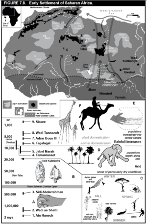
From An Atlas of Human Prehistory by Cameron Smith. Copyright © 2019 by Cognella, Inc. Republished by permission.

Smith’s Atlas of Human Prehistory provides a very readable and broad overview of the evidence for the human prehistoric presence and journey across the globe. Readers who wish to purchase the volume may obtain it at the Cognella publisher website.

Hidden Majesty: The Lost Grave of Richard III

Laura Scandiffio is the author of books written especially for young people, though they can be enjoyed by people of all ages. Among her books are The Martial Arts Book, Escapes!, People Who Said No, and Outlaws, Spies, and Gangsters. She currently lives in Toronto, Canada with her husband and two children.

England, August 22, 1485: On a summer morning, two armies approach from opposite directions. Soon they will meet in fields skirted by marsh in the heart of England’s countryside.

The larger army pauses where it commands the higher ground, enjoying an advantage over the still-unseen enemy. Its leader is King Richard III. His opponent is Henry Tudor, a challenger for the throne, backed by an army of French mercenaries and Welsh supporters. Richard knows Henry’s troops will come this way as they head toward London, and Richard’s English soldiers will be waiting to intercept them.

Before setting out after dawn, the king paraded in armor on horseback before the line of his army, 8,000 strong, their banners fluttering in the breeze. He placed the royal crown on his helmet for all to see. It is a solemn ritual to symbolize his right to rule and to remind them of the loyalty they owe him. Richard knows that if he can defeat Henry today, he will destroy the only real threat to his throne.

Henry Tudor’s army appears in the distance. It is much smaller, a little over 2,000 men. Henry is unsure of his chances and remains in the rearguard, the better to escape should things go wrong.

The fighting begins, and the odds are in the king’s favor. Then Richard does something as unexpected as it is bold. He gives up his place on the high ground and personally leads a cavalry charge, skirting the enemy army and galloping straight for Henry himself.

It is all over quickly. Richard is killed, the last English king to die in combat, at the Battle of Bosworth Field. Henry orders Richard’s body to be stripped and draped over a horse and led to the nearest city, where it will be displayed for all to see and believe—Richard is dead, and Henry is now king.

“As for King Richard, he received many mortal wounds and, like a spirited and most courageous prince, fell in the battle on the field and not in flight.”Crowland Chronicle

This much was known to be true. But how exactly did Richard die? Where was he buried? Most important, were the terrible stories later told about this controversial king an honest portrayal? Historians puzzled over these mysteries for centuries. It was only with modern technologies—from DNA sequencing to forensic science and medical imaging—that the truth could be uncovered and a true portrait of a notorious king vividly painted.

_____________________________

King Richard III on horseback at the Battle of Bosworth. From Doyle, James William Edmund (1864), “Richard III” in A Chronicle of England: B.C. 55-A.D. 1485, London: Longman, Green, Longman, Roberts & Green

_____________________________

The site of the Battle of Bosworth Field in Leicestershire, England. David Hughes / Shutterstock

_____________________________

“History Is Written by the Victors”

Henry Tudor took the throne as Henry VII, and, little by little, the reputation of the defeated King Richard was destroyed. Chroniclers who had once praised Richard now condemned him. Did they at last feel free, now that he was dead, to tell the truth? Or was there another reason?

Henry VII undoubtedly had a strong motive to ruin Richard’s name. His own claim to the throne was shaky—based on victory in battle rather than bloodlines—and he needed to strengthen it. One powerful way to do that would be to present himself as England’s savior, the king who overthrew a tyrant. Henry cast doubt on Richard’s own right to the throne, claiming that Richard had staged a coup to take the throne from the rightful heir, his nephew Edward.*

_______________________________

*THE PATH TO THE THRONE

Richard III was born in 1452 and was King of England from 1483 to 1485. He was the younger brother of King Edward IV. When Edward died, the king’s 12-year-old son was crowned Edward V. Richard took on the role of lord protector, running the government for the boy, who was too young to rule on his own. That same year, Richard brought forward evidence that his nephew was in fact illegitimate and therefore could not be king. Richard was crowned instead. Edward and his younger brother were sent to live in the Tower of London, and eventually disappeared. It was long rumored, but never proven, that they were murdered by their uncle, the new king.

_______________________________

It has often been said that history is written by the victors. Could this explain what happened in the case of Richard III? Did chroniclers join a smear campaign to win favor with the new regime? If so, it worked extremely well.

With each retelling of his story, Richard became more villainous. He was blamed for more murders and crimes—all, apparently, part of his diabolical plan to seize power. The list of his alleged victims eventually included Henry VI; his brother George; his two nephews; his wife, Anne; and various nobles.

And what about his physical appearance? He had a crooked back, they said, a limp, and a withered arm. A physical deformity, medieval people thought, was a sign of inner evil—or of God’s punishment. The man was obviously a monster!

A century of attacks reached a climax in William Shakespeare’s play King Richard III. His Richard is a hunchbacked schemer without a conscience, who kills for power and delights in his own wickedness.

A few people began to ask: Could Richard really have been so bad? Even his worst enemies had praised his courage in battle, and others agreed that as king he had upheld justice. Yet for the next three centuries, the image of Richard-as-villain stuck, and most historians accepted it. The real Richard seemed to be lost in a tangle of exaggerations, myths, and half-truths.

Even his grave had disappeared.

___________________________

King Richard III. NPG 148 / National Portrait Gallery, from David Williamson, The National Portrait Gallery History of the Kings and Queens of England

___________________________

___________________________

How Do You Lose a King’s Grave?

It is surprising and bizarre—how could the grave of someone as important as a king get lost? Accounts written in the first years after Richard’s death are sketchy, but it seems that for two or three days his corpse was displayed publicly in Leicester, the city nearest the battlefield. This was on Henry’s orders, to prove Richard was dead. Richard was then buried “without any pomp or solemn funeral”—dropped into a hastily dug pit—in the floor of a local church. Two later accounts confirmed this was in the church of the “Greyfriars,” friars who wore gray robes.

In the 1500s, during a period of religious upheaval in England, many churches were destroyed, including the Greyfriars priory. A story began to circulate that, in the turmoil, Richard’s remains had been dug up. An angry mob had carried his body through the streets and dumped it into the river. In the 1600s, historian John Speede wrote that Richard’s now-empty gravesite was in ruins, and his stone coffin had been made into a drinking trough for horses. Most historians accepted this account. There was no evidence to refute it.

In the centuries that followed, new buildings rose over the ruins of old ones, and the medieval city vanished beneath them. And with it disappeared any certainty about where Richard’s final remains might be.

An Ancient Map and a DNA Sequence

In 2004, English historian John Ashdown-Hill took a closer look at Speede’s account of searching for Richard’s grave and the map he had drawn. He discovered that Speede had made a mistake: he had gone to the site of the Blackfriars priory, not the Greyfriars! Could Richard’s remains still lie somewhere under modern Leicester?

At the same time, Ashdown-Hill had been asked to help identify a set of bones buried in a Belgian church. They might be the remains of Richard’s sister Margaret of York. Could he produce a DNA sequence* for Margaret to confirm it was her? To do this, he would need a DNA sample from one of her descendants. First, he would have to trace a family tree, mother to daughter, to a living descendant of Margaret’s. Technology was now available to compare that person’s DNA with the DNA of the skeletal remains and see if they matched.

Margaret’s family tree died out, so Ashdown-Hill tried again with Richard’s older sister Anne. He scoured baptismal registers, census data, and family letters. To his growing amazement, the line kept going, mother to daughter. Richard’s sixteenth grandniece was living in Canada—Joy Ibsen. When Ashdown-Hill contacted Ibsen with the news, she was stunned. She had no idea she was related to the infamous king.

______________________________

*mtDNA

Our cells contain two types of DNA. Nuclear DNA is a fifty-fifty mixture of both parents’ DNA. But mitochondrial DNA (mtDNA) is inherited entirely from the mother unchanged. Richard and his sisters would have had identical mtDNA, inherited from their mother. Yet only his sisters would pass on that mtDNA to their children, and only their daughters could pass it on in turn.

______________________________

Richard had no direct descendants. But Ashdown-Hill realized that just as a mtDNA match with Ibsen could prove that the skeleton in Belgium was Margaret’s, it could also prove the identity of Richard’s remains––if only his lost burial place could be found.

An Eerie Intuition

Philippa Langley, a writer living in Edinburgh, was visiting Leicester in 2004 to get ideas for a screenplay. She believed history had been unfair to Richard III and that his life would make a dramatic movie. Maybe walking the streets of the city he visited before his final battle would provide inspiration.

Langley headed to a parking lot on New Street. A portion of a ruined medieval wall in the modern car park had prompted rumors that the Greyfriars church might have once stood there. She walked past the cars to the stone wall, but nothing seemed helpful to her quest. As she exited, she noticed another parking lot across the street, behind gates and a “Private” sign. Curious, she slipped through and walked across the lot toward a red brick wall at the other end.

As she neared the wall she felt the oddest sensation: “My heart was pounding . . . I had goose bumps, so much so that even in the sunshine I felt cold to my bones. And I knew in my innermost being that Richard’s body lay here. Moreover I was certain that I was standing right on top of his grave.” But would anyone believe her?

A Million to One

Five years later, Langley invited Ashdown-Hill to Edinburgh to give a talk to the local Richard III Society, a group that shared their keen interest in the king. She told him about her instinct; he explained his research. He believed he knew where the Greyfriars church had been located: it must be at the northern end of the parking lot where she had stood. Langley made a decision. With the help of the Richard III Society, she was going to search for the king’s grave!

Many people scoffed at the idea that a king was lying forgotten underneath a modern parking lot, but Langley was determined. Like Ashdown-Hill, who guessed that clues to the truth might lie in the king’s DNA, Langley hoped finding a body would “bring to light the real Richard.”

Langley convinced the city council to permit a dig in the parking lot, then met with archaeologist Richard Buckley from the University of Leicester. He was intrigued by the idea of finding the lost Greyfriars church. It might reveal new insights about medieval Leicester and life 500 years ago. They struck a bargain: Buckley’s team would search for the church; Langley would keep her fingers crossed that the excavation would also turn up a grave.

Buckley guessed the chances of finding the church were about fifty-fifty. The grave of the king, however, was beyond a long shot. “A million to one,” he joked.

Tearing Up the Tarmac

In August 2012, Buckley’s team prepared to break ground. The excavating machine roared into action. Its driver swung the mechanical arm with its clawlike scoop, which began to chew up the tarmac of the first trench. To everyones disappointment, the first bits of stonework they found turned out to be the remains of a Victorian outhouse.

Matthew Morris, the site director, suddenly raised his hand in the air, and the roar of the excavator stopped. About 1.5 m (5 feet) down, a long bone was visible in the soil. It looked like a leg bone. Using a trowel, Morris gently removed the earth around it. Slowly, a second bone came into view, lying parallel to the first. It looked like two legs, side by side. Could it be part of a skeleton?

Morris reminded Langley not to jump to conclusions. These could be from any century and might belong to anyone. So far they hadn’t found a scrap of medieval stonework that might locate the church. In any case, they could not disturb the bones until they had applied for a license to exhume human remains for archaeological purposes.

As the dig progressed, bit by bit, evidence of a medieval building came to light—decorated tile and stained glass. Several days into the dig, the team uncovered unmistakable evidence of church walls and graves. It was enough to convince Buckley to apply for a license to exhume the human remains.

______________________________________

Above and below: Archaeologists uncover clues as they excavate the parking lot. University of Leicester

______________________________

______________________________

Map of the excavation, with three trenches cut across the parking lot. University of Leicester

______________________________

Bringing the Bones to Light

Team members prepared to uncover whatever lay alongside the leg bones. They donned forensic suits that covered them from head to foot, to avoid contaminating the bones by shedding their own DNA, and stepped gingerly into the trench. Jo Appleby, an osteologist (an archaeologist specializing in human bones), worked with a mattock, an ax-like tool with a broad blade, to chip her way down and look for any more skeletal remains.

It was indeed a human skeleton. The feet were missing—probably cut off when a wall was laid in the 1800s. Other construction had missed the head by millimeters. Possibly this was a friar, buried in the church?

Appleby next uncovered something startling. The skeleton’s skull was raised and leaning forward toward the chest, and the spine clearly curved to one side, like a C. Langley was shocked. It couldn’t be; she had felt sure that if they found Richard, his spine would be straight, disproving the hostile descriptions. Maybe this wasn’t Richard at all. But if it was . . . did that mean the stories about his physical deformities were really true?

The team filmed and photographed the skeleton where it lay. Then each bone was carefully removed and placed in a clear plastic “finds bag.” Altogether they fit in a cardboard box. The archaeologists remained cautiously neutral about the identity of the remains. But Langley and Ashdown-Hill felt differently. They had brought a replica of Richard III’s royal banner, which they draped over the box before Ashdown-Hill carried it to the waiting van.

____________________________

The skeleton discovered in the first trench. University of Leicester

____________________________

A Case for Forensic Science

The van headed to the University of Leicester. There, a team of experts would analyze the skeleton from different angles. Their approach would be like fitting together the pieces of a puzzle. The bones were treated like a modern forensic case—what would they reveal about the individual, how he died, and possibly who he was?

The first step was to conduct a CT scan of the bones. The scientists could now see inside each bone, without cutting anything open. As part of this process, digital images from the CT scan were used with a 3-D printer to create a model of the skeleton. The model skull was so precisely lifelike that even growth rings could be seen!

Meanwhile, the bones were subjected to carbon-14 dating*, to get a rough idea of their age. Two samples from rib bones were sent to different labs to cross-check the results.

The outcome was a disappointing setback. It was 95 percent probable that this person had died between 1430 and 1460. But Richard III was killed in 1485. It looked as though the skeleton might be too old to be his.

___________________________

*NARROWING THE RANGE

Radiocarbon dating cannot pinpoint an exact date, it can only estimate a range of dates along with a percentage of accuracy. Two results are usually given. The first indicates a 68 percent chance that the correct age lies within a span of years; the accuracy increases to 95 percent when the range of years is doubled.

___________________________

Then new information added a twist. Other isotopes (different versions of the same chemical element) in the bones revealed details about the person’s diet. This man had eaten a lot of seafood. Marine organisms absorb large amounts of carbon-14, so all the seafood he had eaten likely threw off the test. The result was corrected, and now the date of death was 95 percent probable to have been between 1430 and 1530.

Further isotope analysis revealed more clues. Isotopes in teeth formed in childhood and the early teens retain signs of water and food grown in different regions, showing where a person lived while growing up. These matched what was known of Richard’s early years—he and his siblings had moved around, often on the run from their family’s enemies. It was also clear that in the last few years, this person’s diet had changed drastically. Hed begun to eat lots of expensive meat, fish, and fowl—a diet of banquets, fit for a king!

Richard the Monster?

From the skull, Appleby concluded that this was a man in his late twenties to late thirties (Richard died at 32). A closer look also revealed that he did not have kyphosis, the condition once called “hunchback.” The position of the skull, shoved forward onto the chest, had misled her into thinking the back was hunched, but now it was clear this was just because the body had been dropped into a grave that was too short.

The upper spine was, however, curved sideways. Its owner had had another condition: scoliosis. The 3-D model of the spine was studied by Piers Mitchell, a scoliosis expert. Scoliosis would not cause a hunch, but the twisting shape of the spine would make the right shoulder slightly higher than the left. This would not have been visible when the person was dressed, and he would have been capable of regular physical activity. The leg bones were normal, so he would not have walked with a limp.

Appleby confirmed that there was no withered arm. Both arms were normal. Whoever he was, he had probably been 1.7 m (5 feet, 8 inches) tall, about average for the Middle Ages.

If this was Richard III, the bones proved that the stories about his hunchback, limp, and withered arm were deliberate exaggerations and distortions of the truth.

The Final Blow

The next challenge was to determine the cause of death. Appleby was joined by a forensic pathologist and a trauma expert who worked on modern murder cases to identify the source of cut marks in human bone. Robert Woosnam-Savage also joined the examination. As curator of armor and weapons at the Royal Armouries Museum, he was familiar with medieval battle injuries and the weapons that inflicted them. Together they looked at each bone for the slashes of sword wounds or the deeper V-shaped stab marks of daggers.

There was no doubt this man had died a violent death. The skull bones had damage from multiple attacks using different weapons. Two of these blows could have been fatal and were likely made by a halberd (a weapon with an ax blade and spike on top of a wooden shaft)*. This confirmed one account written shortly after Richard’s death: “One of the Welshmen then came after him, and struck him dead with a halberd.” No battle injuries were found on the body, which must have been well protected by armor. Unusually, the face had been left mostly unharmed. It looked like this victims attackers had wanted him to remain recognizable after death. Henry Tudor had indeed displayed Richard’s body so there would be no doubt that the former king was dead.

_____________________________

*Fatal Contest

In 2010, the true site of the Battle of Bosworth Field was finally located on the edge of a marsh by archaeologists. Piecing together clues from the battleground with the forensic results from the skeleton, it was at last possible to reconstruct Richard’s final minutes.

After Richard’s cavalry charge was warded off by Henry’s soldiers, armed with pikes, Richard’s horse probably lost its footing in the marshy ground, and he was thrown off. Now he was vulnerable in the midst of his enemies, who surrounded him. His helmet was torn away, and his opponents rained blows on his unprotected head. He defended himself vigorously to the end, which came quickly.

_____________________________

Battleaxe: The final blow axe (illustration). markgoddard / iStockphtot

___________________________

Facial Reconstruction: The Science of Recreating a Human Face

There are several portraits of Richard III, but these are artists’ impressions. Now there was a chance to accurately recreate the face of the king. The science of facial reconstruction, working from a skull outward, has become a proven method of identifying remains in forensic investigations—from murder cases to disaster victims.

A skull is as unique as a face, but we cannot recognize it until the overlying muscles and tissues are added. Digital technology has made the process faster and more accurate. Caroline Wilkinson, an anthropologist and professor of craniofacial identification, worked with high-res photos and 3-D CT scans of the skull. As the image of the skull rotated on her monitor, Wilkinson added eyeballs and tissue. Using a haptic arm—a device that translates the movements of her right arm and hand into on-screen changes—she was able to model the skull like a sculptor working with clay.

A life-size 3-D printout of the head was given to a digital artist, who added hair, skin, and eye color. The finished face took Langley by surprise: “It was the face of a young man who looked as if he were about to speak, and to smile. I searched in vain for the tyrant. I can’t describe the joy I felt. I was face to face with the real Richard III.”

___________________________

The face of the king: facial reconstruction of Richard III. University of Leicester

___________________________

DNA: The Last Puzzle Piece

It was time to proceed with a DNA comparison to a living descendant of Richard’s sister. Ibsen’s son Michael lived in London, where he worked as a cabinetmaker, and he had agreed to give a live DNA sample, taken at the parking-lot dig itself. The DNA evidence would be the most essential piece to clinch the identification.

Ancient DNA is delicate. Teeth are often the best-preserved parts of a skeleton, and the femur is thick, so samples were taken from each of these. If both samples yielded the same results, it would help to rule out the possibility that the DNA had been contaminated. The DNA sequencing was carried out by two specialist ancient-DNA labs to cross-check the results.

Ibsen’s DNA was then compared to the skeleton’s DNA sequence produced by both labs. Both yielded the same result: a perfect match! All the evidence was next subjected to a statistical analysis. The probability that the skeleton belonged to Richard III lay between 99.9994 and 99.9999 percent.

The team of archaeologists and scientists made their announcement to the world at a press conference. After the experts went through the evidence, Buckley declared that “beyond reasonable doubt, the individual exhumed at Greyfriars in September 2012 is indeed Richard III, the last Plantagenet king of England.”

The Return of the King

In 2015, King Richard III was reinterred in Leicester Cathedral, in a coffin made by his seventeenth-generation nephew Michael Ibsen. Langley was satisfied that one of her crucial goals had been accomplished: an honorable reburial for Richard in the royal tomb that Henry VII had denied him.

Langley’s far-fetched hunch had paid off. The archaeologists pointed out that this was an amazing find, not just because Richard was a king, but because finding a named individual 500 years old, along with the opportunity to analyze the remains, is “extraordinarily rare.” By applying analysis from every relevant stream of knowledge—genetics, medicine, forensics, genealogy, history, and archaeology—the researchers were able to look in incredible detail at the life of a king from the vanished Middle Ages. His life and times—how and where he grew up, what he ate and drank, the wounds that killed him—were all brought to light.

_________________________

A royal tomb for Richard III in Leicester Cathedral. Jacek Wojnarowski / Shutterstock

_________________________

What We Thought We Knew . . . and What We Know Now

So, was Richard a good king whose reign was cut short by treason, or a deposed tyrant? The evidence of the bones helped to strike a balance between the two extremes: by confirming what grains of truth lay in the confusion of accounts, a reputation was restored and a caricature turned back into a recognizable human being.

Perhaps the last king of England’s Middle Ages was a man of his stormy times, a capable person in whom ambition and a sense of duty coexisted. The truths about his character and his intentions are still left for historians to puzzle over.

The search for King Richard III has taught us that in looking for the truth about a person, science can be applied not just to a skeleton but to history as well. What history has long told us about Richard was held up to the same kind of scientific test as the bones. Legend and fact were separated—the king was not a monster, his body was never thrown in the river, and his coffin was not turned into a horse trough. If these parts of the historical record were untrue, what else might be? The discovery of the lost king is a powerful reminder to view historical “facts” with an open and objective mind.

____________________________________

From Digging Deep: How Science Unearths Puzzles from the Past © 2019 Laura Scandiffio, published by Annick Press Ltd. All rights reserved. Reproduced with permission.

Digging Deep: How Science Unearths Puzzles From the Past by Laura Scandiffio, shows archaeological discoveries that have made scientific advancements and are now brought to light. From the timeline of the northwest passage to the Kmhere empire, this book is a great STEM resource for those interested in ancient and modern history and those who want to know the science behind such discoveries. More information about purchasing and ordering this book can be obtained at the Annick Press website.

Caravans of Gold, Fragments in Time

Kathleen Bickford Berzock is associate director of curatorial affairs at the Block Museum of Art at Northwestern University. She is the author of For Hearth and Altar: African Ceramics from the Keith Achepohl Collection and the coeditor of Representing Africa in American Art Museums: A Century of Collecting and Display.

This article is available to Premium members of Popular Archaeology.

Become a member or upgrade to a Premium membership: REGISTER HERE.

The Human Origins Field Seminar with Briana Pobiner

You can look long and hard, and you will not find a travel opportunity like this one anywhere. But now, finally, a unique educational travel experience has been designed for anyone with a special interest or passion for the field of human origins and human evolution. Called the Human Origins Field Seminar with [Smithsonian paleoanthropologist] Dr. Briana Pobiner, this is what you will experience: 

— In one trip, we will take you across three different African countries to sites where scientific history was made, and is still being made, in cutting-edge research on human origins and human evolution. As such, you will be traveling across more terrain than typical of any standard Africa tour;

— You will meet with prominent, world-renowned scientists who are leading the way with new discoveries in human origins and human evolution;

— You will be given “back-door” special access to the fossil and artifact collections that have and are making scientific history in human evolution research;

— You will be traveling with a Smithsonian paleoanthropologist who has done significant field research in Africa and who will be with you the entire time for lectures, discussions, to lead you through the important sites, and to answer your questions;

— Along with all of this, you will have the opportunity to enjoy traveling and observing African wildlife, geography, and geology in three different countries, much of which had a bearing on the kind of environment in which early human ancestors lived;

— This may be the only chance you will have to experience an opportunity this unique, particularly as it may never be offered again.

For more information about this one-of-a-kind travel opportunity, go to the website at http://www.grouptoursite.com/tours/mclerran and join us for the trip of a lifetime!

Should you decide to join us, email me at populararchaeology@gmail.com and let us know you are interested, along with any questions you may have.

Your partner in travel,

Dan McLerran

Founder and Editor

Popular Archaeology Magazine

The Golden Rhinoceros

The waters of the Shashe River join those of the Limpopo close to where the borders of South Africa, Botswana, and Zimbabwe converge. Nearby, on the right bank (on South African territory) sits the Greefswald farm. It is the property of the Republic of South Africa, and its cultural landscape” has been inscribed on UNESCO’s World Heritage List. As for the natural landscape, it is high savanna, home to the thorn tree and mopane, covered with grass in the rainy season and dotted here and there with enormous baobab trees. Mapungubwe, the “hill of the jackals” in Venda (a language of southern Africa), is a steepsided sandstone outcrop that gives its name to a collection of archaeological sites in the vicinity dating from the tenth to the thirteenth century. During apartheid, this site was one of the battlefields over the country’s past (the skirmishes were fought among white academics, it goes without saying): was it possible, the whites asked, that black Bantus were responsible for Mapungubwe, or was it necessary to invoke some other population with a more noble pedigree? Was it possible that the Africans who had lived and prospered here were the ancestors of the black South Africans then confined to Bantustans, or “reserves, and townships? Was it possible that civilized natives had preceded white colonists on ground where the latter believed, or gave the impression of believing, that they were the first occupants?

As befits a place that is today considered the “capital” of the first South African kingdom, the objects discovered there have become the country’s “crown jewels,” and the history of their transmission to our own time, an archive. From the moment of its discovery, a story developed that gave prominence to white heroes—as could only be expected of a site for which the colonial elite was both the discoverer and the exegete—just as elsewhere colonial settlers and Western readers were fond of a white queen of the Atlanteans. As is often the case when lieux de mémoire are at stake, this intrigue transformed a banal story of pillage into an allegory that romanticizes the circumstances of the objects’ discovery.

It is therefore a story of mystery and friendship, which perhaps really happened in the way it’s been told, but is no less mythical for it. In his youth, Francois Bernhard Lotrie had served as guide to missionary and explorer David Livingstone; he had been a gold prospector and elephant hunter. At the beginning of the twentieth century (he died in 1917), Lotrie settled in the Soutpansberg massif not far from Limpopo. Here, we are told, the eccentric, solitary old man gave an African friend, Mowena, an ancient piece of terra-cotta pottery. It was said that he had taken treasures from a sacred hill he had discovered. Around 1930, a group of young men went for a weekend hunt in this same region. Of course, they were whites, for only whites could freely cross the property of other whites. While looking for water, they came across an old man, an African, who diligently and respectfully offered them refreshment. The old man was Mowena. One of his young guests, Jerry Van Graan, a student of history at Pretoria, was intrigued by the vessel to which he put his lips: the celebrated terra-cotta. Returning in December 1932 with a group of his friends, he managed to identify and climb the hill on the Greefswald farm. There they discovered tombs, and they spent days disturbing them, laying hands on a small rhinoceros made of gold foil. Completed much later from scattered data, the retrospective inventory of three disturbed tombs (out of around thirty) reveals that they were shallow graves, perhaps surmounted by stone slabs, where the dead were buried in a sitting position, unless the skeletal remains had initially been buried elsewhere before being reburied there. The graves contained several golden animals, the gold casing of a “scepter” or a cane as well as a headrest, gold filigree jewelry, thousands of gold beads, tens of thousands of glass beads, and both intact and broken pottery.

Seized with misgivings, the young man would later write to Leo Fouché, his former history professor, to inform him of his discovery. Fouché, a liberal Afrikaner, immediately had the farm bought by the state, purchased objects coming from the site that had not already been dispersed or melted down, and launched the first excavation campaign. It was learned that other clandestine visitors had climbed the hill during the 1920s. Since then numerous structures have been excavated, a remarkable series of objects have been discovered, but of course information we would like to have about the disturbed graves themselves is lost forever. The golden rhinoceros is nothing more than a recovered stolen document, except that a stolen archaeological artifact will always remain lost—even if it is rediscovered: it will always be missing the associations its original context would have allowed us to observe.

The archaeological research carried out over several decades at Greefswald has revealed stratigraphic deposits several meters thick, not only at the top of the hill but also at its base, as well as at several other sites within a radius of a few dozen kilometers from the hill. The sequence of occupation illustrates an increase in population size and social differentiation between the tenth and the thirteenth century. Social differentiation is especially noticeable toward the summit of Mapungubwe, an area occupied by a new elite from the end of the twelfth century, and toward the upper end of the stratigraphic deposit, corresponding to the last occupations a little before 1300, when high-ranking individuals had themselves buried there with their wealth, thereby denying it to the living. But can we refer to them as kings without presupposing the nature of a political formation we can apprehend only very imperfectly through the prism of archaeology? Let’s stick with kings, if the golden objects are to be taken as royal symbols or evidence of royal status, but only if we don’t forget the other dimensions of the society the archaeological data shed light on. Here medieval societies were distinctly pastoral. At the excavated sites, domestic spaces were spread out around a vast central corral, a sign of the important place cattle occupied not only in the economy and diet, but also, more generally, in all social transactions, notably matrimonial ones, as was the case in the societies of southern Africa in later centuries. The numerous clay animal figurines, particularly of cows, that come from this region further reinforce this point.

To better grasp Mapungubwe’s significance, we must zoom out to measure the regional synchronies while also honing in on the elements of material culture. That the rise of the sites on the right bank of the Limpopo is linked in one way or another to the development of mining on the plateau on the other bank, in current-day Zimbabwe, is very probable, partly because, as far as we know, gold was not exploited on the South African side until the colonial era. That strong social distinctions and spectacular evidence of the accumulation of gold begin to appear in this fluvial region at exactly the same time as the oldest mentions of a gold trade with the south coast of East Africa is equally remarkable. A triangular relationship thus took shape about which we can be even more precise. The minute glass beads, found in the thousands during the excavation, likely originated in Arikamedu, near Pondicherry, in southeast India, unless they came from another atelier in the Indo-Pacific” production zone. Like the cowries from the Maldives, or the fragments of Song dynasty greenware, celadon,” these beads bear witness to the trade nourished by the commercial zone of the Indian Ocean. In exchange, did the little “kingdom” of Mapungubwe export elephant ivory (we have found bracelets whose standardized form and technique suggest serial production); the skins of cats and other carnivores, if we are to judge by the bones of genets, civets, leopards, servals, and lions that show signs of cut marks, and which have nothing to do with food waste; and gold? Perhaps, although only gold objects (beads, jewelry, objects finished with gold leaf) have been uncovered, not ingots, which would soon have been melted down. But it’s not necessary: Magpungubwe Hill could have traded in several directions with its new regional partners without necessarily being their intermediary. It could have profited from this trade by amassing a treasure out of goods that the other regional partners bought or sold for their weight value. Symbolically, a golden rhinoceros was something more than a gold nugget or a dinar.

The little rhinoceros is perhaps, in its way, evidence of the existence of a network of contacts even more complex. Reassembled, then restored, the object measures a little more than fifteen centimeters long. It is solid in appearance; the neck looks more “robust” than that of the real animal. But its compact appearance, the projection of its shoulder line, and its lowered head reinforce the feeling of power that emanates from the figurine. Lines of small, regular perforations indicate that the hammered foil was riveted to a wooden core, which is corroborated by the gold pins found during the sieving of the sediment from the graves. The animal’s tail is a thin, solid gold cylinder, the ears delicately cut out-turned ovals, the eyes two small half-globular “upholstery nails,” the horn a gold foil cone. The horn? It has long been pointed out that unlike the African rhinoceros, which has two horns, the golden rhinoceros of Mapungubwe has only one. Its excavators, custodians, and restorers were categorical on this point: it had never had a second horn. We can see here a simple stylistic feature or the representation of an Asian species, the Indian rhinoceros (Rhinoceros unicornis) or the Javan rhinoceros (Rhinoceros sondaicus), both of which have a single horn. For this reason, some scholars have considered the rhinoceros, emblematic of the site and the history of South Africa as a whole, an imported object. That is unlikely for its golden carapace; studies done on the geochemical fingerprint of the metal from several gold objects found at Mapungubwe point to a regional provenance. But it re- mains a possibility for the object’s missing part: its core, certainly made of wood, which began to slowly disintegrate as soon as it was buried. Only a meticulous excavation could have yielded fibers whose analysis might have revealed its species and age.

We will thus stick with the hypothesis that the wooden figurine was perhaps made elsewhere than Africa, and was gilded on the banks of the Limpopo as a sign of its appropriation by royalty. At any rate, this hypothesis is not even necessary if one simply wants to illustrate the emergence of a power capable of harnessing the political benefits of a commercial relationship with unknown worlds. For Mapungubwe, with its society based on a traditional agricultural economy, was situated both beyond the horizon of regular Islamic trade—probably even beyond the limits of the land known to the coastal African merchants—and at a good distance from the goldfields of the Zimbabwean plateau.

Bibliographical Note

Th Order of Mapungubwe, established in 2002, is the highest distinction awarded by the Republic of South Africa; its insignia incorporates the golden rhinoceros. The account of the site’s discovery is taken from Sian Tiley, Mapungubwe: South Africa’s Crown Jewels (Cape- town: Sunbird Publishing, 2004), which catalogs the objects kept in the museum dedicated to Mapungubwe at the University of Pretoria. The original excavations by Leo Fouché were published in Mapungubwe, Ancient Bantu Civilization on the Limpopo (Cambridge: Cam- bridge University Press, 1937). The Mapungubwe Cultural Landscape was added to the list of World Heritage sites in 2003. For a presentation of the site as a “cultural landscape,” see Jane Carruthers, “Mapungubwe: An Historical and Contemporary Analysis of a World Heritage Cultural Landscape,” Koedoe 49 (2006): 1–13. Andrie Meyer, “K2 and Mapungubwe,” South African Archaeological Society Goodwin Series 8 (2000): 4–13, delivers an excellent synthesis of the stratigraphic sequence. For a retrospective inventory of the tombs’ contents and an updating of the anthropological data based on unpublished photographs, see Maryna Steyn, “The Mapungubwe Gold Graves Revisited,” South African Archaeological Bulletin 186 (2007): 140–146. Some samples of gold from Mapungubwe have undergone a spectrometric analysis; see B. Grigorova, W. Smith, K. Stülpner, J. A. Tumilty, and D. Miller, “Fingerprinting of Gold Artefacts from Mapungubwe, Bosutswe and Thulamela,” Gold Bulletin 31 (1998): 99–102. Linda C. Prinsloo, Nigel Wood, Maggi Loubser, Sabine M. C. Verryn, and Sian Tiley, “Re-dating of Chinese Celadon Shards Excavated on Mapungubwe Hill, a 13th Century Iron Age Site in South Africa, Using Raman Spectroscopy, XRF and XRD,” Journal of Raman Spectroscopy 36 (2005): 806–816, off s a new dating of Chinese greenware fragments that enables us to determine when the site’s sequence of occupation ended. Finally, a study of glass beads has recently been done by Marilee Wood, “Making Connections: Relationships between International Trade and Glass Beads from the Shashe-Limpopo Area,” South African Archaeological Society Goodwin Series 8 (2000): 78–90, from which is borrowed the hypothesis of an Indo-Pacific origin. The animal data come from Elizabeth A. Voigt, Mapungubwe: An Archaeozoological Interpretation of an Iron Age Community (Pretoria: Transvaal Museum, 1983). Two new gold foil figurines— one a humpbacked bovine, the other a cat—were reassembled from fragments in 2009 and are on display in the Mapungubwe Museum in Pretoria. For a vigorous perspective on the various historical interpretations of Mapungubwe, see Munyaradzi Manyanga, Innocent Pikirayi, and Shadreck Chirikure, “Conceptualizing the Urban Mind in Pre-European Southern Africa: Re- thinking Mapungubwe and Great Zimbabwe,” in P.J.J. Sinclair, G. Nordquist, F. Herschend, and C. Isendahl (eds.), The Urban Mind. Cultural and Environmental Dynamics (Uppsala: Uppsala University, 2010), pp. 573–590. Th University of Pretoria has published a compendium of numerous documents relating to the history and institutional environment of the excavations at Mapungubwe: S. Tiley-Nel (ed.), Mapungubwe Remembered: Contributions to Mapungubwe by the University of Pretoria (Pretoria, 2011). Among the reproductions of important documents are Van Graan’s letter to Fouché and the transcript of an interview in which the aged Van Graan recounted the circumstances of the discovery.


From THE GOLDEN RHINOCEROS: Histories of the African Middle Ages by François – Xavier Fauvelle, Translated by Troy Tice, Illustrated by Roland Sárkány. Originally titled le rhinocéros d’or. Original French edition © Alma éditeur, Paris, 2013. Copyright © 2018 by Princeton University Press. Reprinted by permission.

Illustration by Roland Sárká

To read more stories like this one, readers can purchase The Golden Rhinoceros by Francois-Xavier Fauvelle from the Princeton University Press.

From the birth of Islam in the seventh century to the voyages of European exploration in the fifteenth, Africa was at the center of a vibrant exchange of goods and ideas. It was an African golden age in which places like Ghana, Nubia, and Zimbabwe became the crossroads of civilizations, and where African royals, thinkers, and artists played celebrated roles in the globalized world of the Middle Ages. The Golden Rhinoceros brings this unsung era marvelously to life, taking readers from the Sahara and the Nile River Valley to the Ethiopian highlands and southern Africa.

Drawing on fragmented written sources as well as his many years of experience as an archaeologist, François-Xavier Fauvelle painstakingly reconstructs an African past that is too often denied its place in history—but no longer. He looks at ruined cities found in the mangrove, exquisite pieces of art, rare artifacts like the golden rhinoceros of Mapungubwe, ancient maps, and accounts left by geographers and travelers—remarkable discoveries that shed critical light on political and architectural achievements, trade, religious beliefs, diplomatic episodes, and individual lives.

François-Xavier Fauvelle is senior fellow at the National Center for Scientific Research (CNRS) in Toulouse, France, and one of the world’s leading historians of ancient Africa. The author and editor of numerous books, he has conducted archaeological digs in South Africa, Ethiopia, and Morocco.

Join Us in the Land of the Ancient Maya

Popular Archaeology is assembling a small group of subscribers to explore some of the most iconic sites of the ancient Maya. We will join the Maya Research Program, the organization that has developed and runs this special itinerary. For 11 days over the New Year’s holiday period between 2018 and 2019, we will travel through Belize and Guatemala to visit sites such as Cahal Pech, Tikal, Uaxactun, Seibal, and Yaxha, as well as two sites visitors rarely get to see — Holmul and Naranjo. The itinerary will also include other fascinating cultural stops, of course. The landscape features and scenery, which will include traversing lakes and rivers, will frame our journey.

This is a tour with purpose, as your participation will help the Maya Research Program’s important research and conservation efforts related to ancient Maya sites, and I will be personally attending as a journalist to talk to the Maya Research Program scientists for stories to be published in future issues of the magazine. 

Tikal, one of the largest and most visited ancient Maya sites, will be one of many stops.

If you are interested, please inform me by emailing me at populararchaeology.com and go to the tour website for more details and to register.

I look forward to seeing you there with me on this special journey through the world of the ancient Maya!


Your Partner in Travel,

Dan McLerran

Founder and Editor

Popular Archaeology Magazine

Top Image: Denis Barthel, Wikimedia Commons

Editor’s Pick: The Best of the Best

Not a year goes by before some incredible archaeological discovery is made. Popular Archaeology has published about some of these compelling findings over the years. Here is a select listing, with links for your convenience, of the most fascinating stories published at Popular Archaeology over recent years. Some of them are free to access without a subscription. For those who do not have a subscription, we invite you to subscribe and enjoy the full list offering here. A year’s worth of premium reading is less than the price for lunch!


The Update: Unearthing New Clues to America’s Lost Colony

New archaeological discoveries may help solve two of historic America’s most compelling mysteries: The fate of the “lost colony” and the elusive location of the first English settlement on Roanoke Island.

______________________________

On the Frontier of an Empire

The Roman fort of Vindolanda in northern England has revealed a fascinating glimpse into the personal lives of people on the cusp between Imperial Rome and indigenous British tribes.

______________________________

In Search of the Historical Jesus

The recent controversial discoveries, and a renowned scholar’s quest to uncover the historical truth about Jesus of Nazareth.

_______________________________

The Tomb of the Griffin Warrior

A rare and rich tomb discovery in Greece opened a window on early Mycenaeans who lived generations before their legendary heroes fought at Troy.

________________________________

Faces from the Past

How an archaeologist-sculptor is bringing bones of the dead back to life.

________________________________

Straddling the Evolutionary Divide

Two remarkable sites are shedding light on a critical transitional period in human evolution.

________________________________

The Tomb of the Warrior King

The newly discovered tomb and contents of a previously unknown pharaoh shed light on a lost ancient Egyptian dynasty.

________________________________

The Real Indy

The story of a forgotten explorer and his intrepid journey to discover great ancient Arabian cities of the Incense Road.

________________________________

The Mummy Doctors

The Penn Museum’s Artifact Lab brings priceless Egyptian artifacts and mummies back to life.

_____________________________________________

Footprints in the Silt

The startling discovery of million-year-old human footprints on a beach in the United Kingdom has scientists jumping.

________________________________

Digging into First Century Jerusalem’s Rich and Famous

Archaeology reveals the signs of a priestly family residence of the time of Jesus.

_______________________________

A Murder in Thebes

A look at an ancient cold case: The sensational death of Egyptian pharaoh Ramesses III.

______________________________

From the Sands of Egypt

The discovery of the world’s largest trove of ancient writings opened an unparalleled window on a vanished world.

________________________________

New Discoveries About Early Humans


In the Summer 2018 issue of Popular Archaeology, two stories relate the recent efforts by scientists to investigate the presence of early humans in Africa and the Arabian Peninsula. The first (Olorgesailie) details the recent findings in the Olorgesailie Basin in the East African Rift Valley that may be shedding new light on the early emergence of Homo sapiens in Africa. The second (One Small Arabian Finger Bone) details a new discovery by scientists in the Nefud Desert of Saudi Arabia that says something about the unfolding story of how, when and why early humans dispersed out of Africa through an otherwise inhospitable environment. Both articles also show how these recent discoveries have added to the latest thinking about how early humans coped with their ancient environments and how those environments shaped the emergence of our own species.

These articles are available to all premium subscribers. 

How Ancient Egypt Shaped the Modern World: An Infographic

When we think of ancient Egypt, for most of us, such things as the pyramids of Giza and the great temple of Karnak come to mind. But you might be amazed to find out that the ancient Egyptian legacy extends far beyond these iconic sites, touching almost all aspects of the society we live in today.

Ancient Egyptian inventions have survived thousands of years. From clocks and calendars to modern beauty regimes.
Source: Produced by Fairmont
 
Cover Photo, Top Left: View of the Giza pyramids. Micetta, Wikimedia Commons
_________________________________________________

rootsoffaithtourpic3

Popular Archaeology will be co-hosting a March, 2017 study tour of Holy Land sites. Locations will include archaeological sites from Tel Dan in the north to Biblical Tamar in the desert south of the Dead Sea, and will include such places as the iconic sites in and around the Sea of Galilee and Jerusalem, Qumran (near the Dead Sea scroll caves), Masada, and an optional stay inside Jerusalem’s Old City walls for an up-close-and-personal experience of the ambience within the Old City. More information about this opportunity can be obtained at the tour page.  


___________________________________________________________ 

farhorizonsad