“Difficile est saturam
Non scribere….”
…..Juvenal
The sardonic muckraker Juvenal claimed that in ancient Rome – with all its foibles, hypocrisy, elitism, and political corruption – one would be hard put to restrain from satirizing it all. The Romans early on grew fond of that form of expression – and its practitioners – and boasted of their lampooning skills. Quintilian, a master of the art, wrote:
“Satura quidem tota nostra est.”
(Satire is indeed all ours.)
The poets Martial and Horace excelled at it too. This literary genre of the Eternal City enjoyed a roaring revival a millennium later. There were no political cartoonists in Renaissance Rome to torment people in high places. But there did exist at the time a group of statue parlanti, talking statues with a flair for satire and a penchant for ridiculing the local authorities, civil, papal, and otherwise, not to mention the aristocracy, the egotistical, the smug.
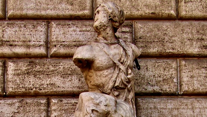
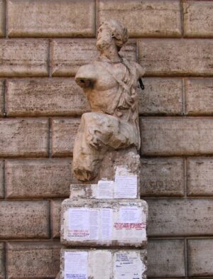
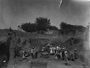
Here is how it all began. In the winter of 1501, a badly mutilated ancient Greek sculpture was unearthed during some work near Piazza Navona in Rome. Numerous art scholars judged it to be the remnant of a group-carving from as far back as the third century B.C. depicting Menelaus supporting the slain Patroclus (from Homer’s Iliad’). An affluent churchman, Cardinal Oliverio Carafa, at once purchased the pitiful marble torso with the battered face and had it placed as an adornment for the north facade of his nearby residence, the Palazzo Braschi. It has stood there ever since.
Each April 25th, the feast day of Saint Mark, the prelate would attach to the statue sayings in honor of the Evangelist. Throughout the rest of the year, Carafa would encourage neighborhood students to affix to the pedestal their innocent poems and epigrams. (In 1510 a certain Giacomo Mazzochi published a collection of the best.)
__________________________
__________________________
It was soon after this, however, that the verses turned malevolent. Written and posted anonymously and clandestinely in the dark of night, the irreverent commentaries targeted the rampant venalities, corruption, and nepotism of church and civic leaders and other pezzi grossi (big shots).
The prevailing wisdom suspected an impish hunchbacked, mischievous tailor by the name of Pasquino. (His shop just across the street was known to be a gathering place for the city’s wits and punsters.)
Whenever the morning’s light brought forth a new satirical pronouncement – in impeccable Latin, no less – word would spread throughout town and become the quote of the day. This was all to the delight of the general populace and to the consternation of the ruling class. No event, institution, or personage was exempt from the caustic pen of Pasquino. Not even the pope was safe from the tailor’s slings and arrows. For Pasquino was, you see, also the official tailor in the Vatican and thus privy to all the gossip in the 108-acre enclave.
One day, for example, when it became clear that Pope Julius II (1503-1513) was devoting more time and energy to military affairs than to Church matters, the statue of Menelaus – by this time affectionately called “Pasquino” – issued a pun on the mandate of Christ to the first pope:
TU ES PETRUS…ET TIBI DABO CLAVES
REGNI CAELORUM
(Thou art Peter…and I shall give unto you
The Keys to the Kingdom of Heaven.)
The tailor put it this way:
“Destiny erred, Julius, in giving you claves (keys).
It should have given you clavas (clubs).”
When Pope Paul III (1534) gave a generous honoraria to the Sistine Choir and then tried to silence the chatty statue, “Pasquino” railed:
“Ut canerent data multa sunt.
Ut taceam quantum mihi, Paule, dabis?
(They were given much so they might sing.
How much will you give me, Paul, to be quiet?)
Around this time, another ancient statue, this one large and in mint condition, was dug up in ruins near the Forum. Found in a reclining position over what was once apparently a fountain, it was thought to represent a river god, and was placed on the bustling street in front of the old Mamertine Prison. The neighborhood wags baptized him “Marforio”. The shabby “Pasquino” started to dialogue with the elegant deity. One day when another sixteenth century pope imposed numerous new taxes, some on the most basic resources, “Marforio,” preferring to communicate in Italian, posed this question:
“Perche metti ad asciugare la camicia di notte e
Non di giorno alla luce del sole?”
(Why do you hang out your laundry at night instead of the day when the sun shines?)
To which the annoyed Pasquino, a few blocks away in a district then called Campus Martius, replied:
“Perche di giorno, con l’aria che tira finerebbero
Per farmi la tassa del sole!”
(Because by day, with the political winds such as
They are, I would end up paying a Sun tax.)
And so it went, on almost a daily basis. Appreciative Romans would dash from “Marforio” over to “Pasquino” to see what his witty pal’s retort would be. (By the way, “Marforio” has, for the last two centuries, resided in the courtyard of the Capitoline Museum.)
Pope Adrian VI, himself often a target of the pasquinades, grew so irritated by these exchanges that he ordered the original garrulous statue to be hammered to bits and tossed into the Tiber. Fortunately cooler heads prevailed. The poet Torquato Tasso convinced the pontiff that the statue’s fragmented corpse would re-emerge into “a thousand creaking lampooning frogs.” In short, Tasso implied, the age-old Roman love for satire would find a way.
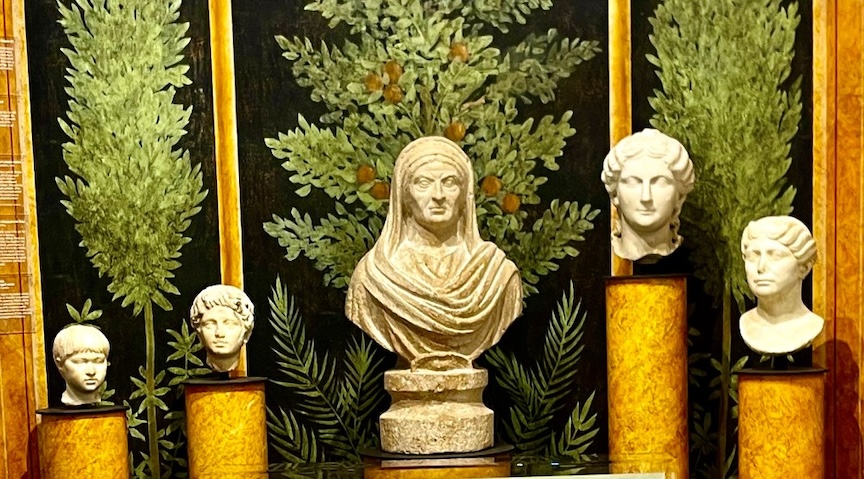
The Talking Statue club grew in time to a membership of six old timers. First came “Madama Lucrezia,” the top half of a colossus of a Roman matron, though many classical scholars think it to be of the Egyptian goddess Isis or perhaps of a priestess of that cult. Madama has been loitering just off Piazza Venezia for centuries now. The buxom madama, the least loquacious of the club, apparently had a low pain threshold for folks who liked to show off their “vast” knowledge. She simply could not bear the company of pseudo intellectuals, so one day at the break of dawn she delivered this Latin broadside at the whole lot of them:
“Qui stultis videri eruditi volunt,
Stulti eruditi videntur.”
(Those who wish to be seen as erudites
by fools, are seen as fools by erudites.)
In her early career a curious custom developed. Roman men, when passing in front of Lucrezia often, in deference to her, either gave a tip of the cap or blew a kiss.
Next came “Il Facchino” the water carrier, featuring a jaunty, tipsy old chap carrying a barrel of water from which he pours an endless stream into the basin of a wall fountain on Via Lata near the corner of Via del Corso.
“Pasquino” had this to say about his new comrade:
Ama il suo liquore di Bacco ma
Offre ai passanti solo acqua.”
(He loves the tasty beverage of Bacchus
But offers to passersby only water.)
”Il Facchino” which literally means “the porter” was the term also used for out of work fellows who scooped up water from the Tiber in kegs and delivered them to people’s homes. This new cottage-industry came about when almost all the ancient aqueducts had by now ceased to function, necessitating the average Romans to get their water from the river.
This was exhausting work. One sad sultry summer day, Signor Abbondio Rizio, a well known and beloved acquaiolo (as they were also called) died on the job.
The following morning “Il Facchino” epitomized the poor guy’s lot in life with this brief obituary:
“Portava quanto peso volle, visse quanto pote, ma un giorno nel portare un barile in spalla, mori.”
(He used to carry as heavy a load as he pleased,
he made a living as much as he could, but one day
While hefting a large barrel on his shoulder, he passed away.)
Then there’s “Il Babuino,” near the Spanish Steps. He’s called the Baboon because of his homely face and his unkemptness. He too is part of a wall fountain and in the opinion of some archaeologists an effigy of Silenus, the half goat, half man comrade of the Greek god of wine, Dionysius.
And lastly the statue with the least seniority, “Abate Luigi” (Abbot Louis) the toga-clad statue often vandalized by decapitation. (He has undergone several head transplants through the years). In the nineteenth century Luigi took up residence in the tranquil churchyard of Sant Andrea della Valle. (He got his name, incidentally, because of his resemblance to the abbot of the monastery attached to the church.) He has this to say on his pedestal:
“Fui della Roma Antica un cittadino
Ora Abate Luigi ognuno mi chiama
Conquistai con Marforio e Pasquino
Nelle satire urbani Eterna Fama
Ebbi offese, disgrazia, e sepoltura
Ma qui vita novella e alfin sicurezza.”
(I was a citizen of Ancient Rome
Now everyone calls me Abbot Louis.
I won with Marforio and Pasquino
eternal fame with urbane satires
I’ve been insulted, disgraced, and buried
but here I have a new life and at last safety.)
So it was out over the rooftops of Rome that these stone rascals – Il Congresso Degli Arguti, “The Congress of Wits,” as they liked to call themselves – carried on their daily gabbing with one another. They enjoyed puns, especially of their target’s name. When Cardinal Giovanni Carafa became Pope Paul IV in 1555 “Pasquino” said:
“Accidenti! Che vino forte in questa carafa.”
(Wow, what robust wine in this carafe.)
(Marforio’s rebuttal?)
Ti sbagli! E aceto.
(You’re mistaken! It’s vinegar.)
……….
Later that century, Pasquino the tailor went to his reward but “Pasquino” the statue rambled on through the ages, right up to the modern era. For there were many amateur satirists in the city eager to perpetuate the infernal jabbering. The Romans referred to these anonymous authors as the pasquinisti.
Pope Urban VIII (1623-44), of the noble and wealthy Barberini clan, launched an ambitious program of monumentalizing Papal Rome, plundering the ruins of Imperial Rome for marble and bronze. By this time the epigrams had shifted back to Latin, thus causing this outcry from “Pasquino:”
“Quod non fecerunt Barbari, fecerunt Barberini”
(What the Barbarians failed to do, the Barberini did)
The other arguti also inveighed against the looting from the wreckage of Old Rome. So then, not even threats of surveillance, of imprisonment, of execution by drowning could put the brakes on the little secret inanimate society of wits.
Later popes loved the city’s Egyptian obelisks and spent great sums moving them around town and crowning each with the Cross, symbol of Christianity’s triumph. With the quality of life at the time not the greatest for the middle and lower classes, the society could not restrain themselves:
“Noi abbiamo basta di obelischi e fontane!
Pane e che vorremmo, pane, pane, pane!”
(Enough already with obelisks and fountains!
Bread is what we would like, bread, bread, bread)
In 1655 Pope Innocent X had as his care-giver in his final illness a sister-in-law, Olimpia Maldachini. Her well-known craving for more wealth impelled her to rob two little boxes of cash, intended for the poor, tucked under the pontiff’s bed. News got out. Some punster got to Pasquino and posted a devilish play on her name with this Latin-gem:
“Olim pia, sed nunc impia”
(Once pious, she is now impious.)
From 1798 to 1808, Napoleon’s occupation of Rome was part of his ambitious scheme to annex the Papal States and expand his empire. “Marforio” could not contain his contempt when the little emperor confiscated many precious works of art:
“Tutti i francesi sono ladri!”
(All the French are robbers!)
Pasquino, in an exquisitely clever play on the real culprit’s surname answered his pal:
“Non tutti, ma buona parte”
(Not all, but a good part… of them)
The acerbic statues were still clucking late into that same century. Hawthorne wrote in his diary while sojourning in Italy in 1859:
“Thence we passed by the pathetic battered torso of
Pasquino…on our way to the bridge of the Angels.”
And on through the twentieth century the marble commentators remained iconoclastically active. When Il Duce in 1929 ordered the demolition of blocks of historic Medieval buildings in the section of Rome still called Il Borgo to make way for his fancy new boulevard, the Via della Conciliazione which leads from the Tiber to the Vatican, the Romans, who tend to cherish their past, were outraged. An anonymous pasquinista had “Pasquino” speak for the people with this placard around his neck:
“Quod non fecerunt Barberini, fecit Mussolini.”
(What the Barberinis didn’t do, Mussolini did.)
When Hitler visited Rome as the guest of Mussolini in May 1938, the proud host had much of the city festooned with buntings and other gaudy decorations. This did not sit well with the local gentry either.
So they took to the ancient rough prototype of today’s platforms of social media, by having “Pasquino” and company air their grievances for them with cardboard signs saying:
Roma de travertino
Vestita da cartone
Saluta l’imbianchino
Suo prossimo padrone
(Rome of travertine
All decked out in papier mache
Greets the house-painter,
Her next landlord.)
The six Arguti are still dwelling at their usual sites in Rome, and still occasionally offering commentary on the city’s political and social goings-on. For there are still plenty of pasquinisti hanging around only too eager to give voice to Pasquino, Marforio, Lucrezia, the Baboon, the Facchino, and even the monastic Luigi.
The reputation of this mischievous squad eventually spread throughout Italy and even across Europe. One Swiss clergyman by the name of Jean Pierre de Crousaz (1663-1750) who had been to Rome and had seen and “heard” the ancient gossipers told his countrymen upon his return:
“These satirists of true genius who are warmed by a genuine indignation of vice, and whose censures are conducted with candor and truth, merit the appreciation of every friend to virtue. They are a sort of supplement to the legislative authorities, assisting the unavoidable defects of all legal and social institutions for the regulation of manners and striking terror, even where the divine prohibitions themselves are held in “contempt.”
By the second century of their existence and local celebrity, the half-dozen stone gadflies now found themselves being cited and quoted all over the continent. The little tailor’s legacy had a long reach. The original Pasquino bequeathed to and taught his legions of fans the word pasquinade, that succinct amusingly polemical way of versing, with the high and the mighty as targets, which generations of Romans, and tourists who were lucky enough to have visited Rome Eternal, passed on to posterity. The stinging, biting satirical form had become an international pastime, until it was gradually obsolesced by the invention and popularity of the political cartoon, and especially by today’s social media outlets like Twitter and Facebook, et al.
Yes, the six mischievous marble codgers of Rome have all been on pension for quite some time now. Yet, if truth be told, every once in a blue moon they will come out of retirement for a day or two to offer their take on the latest whiff of misbehavior emanating from Parliament, the Vatican, or the Campidoglio (City Hall).
__________________________
Advertisement

EXPLORE THE ANCIENT ETRUSCANS IN PERSON!
Experience a unique, up-close-and-personal hike among ancient hilltop towns in central Italy. You will walk the sensational countryside of the regions of Umbria and Tuscany, soaking in important sites attesting to the advanced Etruscan civilization, forerunners of the ancient Romans; imposing architectural and cultural remains of Medieval Italy; local food and drink; and perhaps best of all — spectacular scenic views! Join us in this collaborative event for the trip of a lifetime!


 Outside, the garden hums with life. The fountain sings its quiet song, leaves rustle in the breeze, and the sculptures stand, frozen yet expressive, as if they too are considering the weight of history. Here, time is fluid—ancient and modern, static and moving, all at once.


