Archives

Bread and Wine … Staples and Symbols of Rome

Professor Frank J. Korn has retired from his teaching position on the Classical Studies faculty at Seton Hall University.  He is a Fulbright Scholar at the American Academy in Rome and the author of nine books on various aspects of the Eternal City.  He is listed in Marquis Who’s Who as “a notable classical educator and writer.”  Recipient of the Princeton Prize for Distinguished Teaching, he resides with his wife Camille in Scotch Plains, N.J.  The couple’s three sons –  Frank, Ronald, and John and their families live nearby.  His latest book    Below Rome, the Story of the Catacombs    which he co-authored with his wife, is available on Amazon or from the publisher, St. Johann Press, Haworth, N.J.

Here with A Loaf of Bread beneath the bough

A flask of Wine, a Book of Verse    and Thou

Beside me singing in the Wilderness

And Wilderness is Paradise enow.

                                  —OMAR KHAYYAM


In the minds of people who have been there, many things are readily associated with Rome:  churches and cafes, pines and cypresses, courtyards and piazzas, fountains and ruins.  The image most often associated with Roman cuisine, however, is that of bread and wine.  In the Eternal City, not a table is set without both.

Both elements have, since antiquity, carried an almost spiritual connotation for the Romans and their fellow Italians.  Since bread is made from many grains and wine from countless clusters of grapes, each stands for unity.  In the churches of Rome, the sacramental bread and wine become emblems of brotherhood and love.  During this Jubilee Year of A.D. 2025, pilgrims by the millions will approach the altar rails of Rome’s Catholic churches to receive the bread and wine of communion which Roman Catholics believe to have been consecrated into the body and blood of Christ.

Some Romans even see bread and wine sharing a natural nine-month cycle and kinship with man and woman.  It takes nine months from the time the grain is sown in November until it is reaped and threshed in July to be ground into flour and made into bread.  Before wine can be made, the grapes must be allowed to ripen from March to November.  And, of course, the miracle of human birth also requires a period of nine months.

In very early Roman times, bread was produced at home through a laborious task of grinding grains of wheat into flour with a mortar and pestle.  By the late Republic, the mola versatilis (rotary mill) had been invented, spawning the growth of commercial bakeries.  In 1862, excavators unearthed the baking establishment of a man named Modestus, featuring large brick ovens, along with sturdy stone mills for grinding the wheat, and various tools for the making of bread.

This archeological work in Pompeii also yielded loaves of bread, intact but carbonized, giving us an idea of size, shape, weight, and other factors.  The typical loaf was round, about twelve inches in diameter, five inches in thickness and one pound, or so, in weight.  Curiously, there was a hole in the center, somewhat like our modern coffee cake, and cut into eight pie-wedge-shaped mini-breads.

Panis, bread, quickly became the Roman dietary staple, comprising sixty percent, or more of a person’s main meal of the day (prandium) and a good measure of the breakfast (jentaculum) and evening’s light meal (cena).  A typical vignette at a worksite back then    and to this day    remains a group of laborers on a break, each feasting on a thick chunk of bread, washed down with a flask of vinum.  (Today these workers are often spotted wearing makeshift hats, made from brown paper bags, to ward off the blazing sun.)

There were several varieties of bread turned out by the city’s myriad bakeries.  Panis testutis was a pot bread baked in the oven, while panis artopicius was a pan bread, cooked on top of a stove.  There was seeded bread, sponge bread, whole grain, and cake bread.  The prevalent variety was the lightly salted panis quadratus, as found in the Pompeii and Herculaneum digs.  In his magnum opus, Historia Naturalis, Pliny the Elder discusses bread and bread-making at length, and has lofty praise for the product as being excellent for one’s physical well-being.

The journalist Stacy Nick writes, in one magazine article, of an archeology professor—Emily Wilson at Colorado State University—who seeks to show her classes just how much like us were the ancient Romans.  One student was so taken by the Prof’s lecture on the bread of old Rome that she, Kayla Spahr, went back to her dorm and baked a loaf of panis quadratus, guided by Pliny’s words and by pictures of the loaves discovered in Pompeii.  Wilson contended that the ordinary Roman men of that long ago era who made up the labor force for building the elaborate public monuments, used bread as the main item of their  daily diet.  She liked to say:  “Bread was the substance that built Eternal Rome.”

______________________________

Ancient roman bread, year 76 or 79 CE, from Pompeii, Italy. Jebulon, CC0 1.0 Universal, Wikimedia Commons

______________________________

Bread prices were very reasonable and well within the budgets of even families of meager means.  The very poor received subsidized or free grain from the city’s welfare program known as the Cura Annonae (named for Annona the goddess of the grain supply).  The satirist Juvenal (A.D. 55-130) mocked the government’s domestic policy as one of “Panem et Circenses,” free bread and free spectacles, as a way of keeping the restless rabble in check by ensuring that their stomachs were always full and their minds distracted.  Pliny the Younger lobbied for free books instead of free shows in the arenas.:  Ut panis ventrem sic pascit, lectio mentem,” he would argue:  “Just as bread nourishes the body, reading feeds the mind.”

The poet Horace was more mundane on the subject:  Cum sale panis latrantem stomachum bene leniet,”  i.e.  Bread with salt is enough to calm the stomach that growls.

From the Latin word panis, we English-speaking peoples derive our terms “pantry”, where bread is stored, and “companion,” someone you break bread with.

When setting the table for an elegant dinner party the host would want to be sure that wholesome and delicious bread was included.  Bakers could be hired out for such soirees.  (Loaves of bread would make for nice gifts to the dinner guests when leaving.)  There remains in Rome a street called Via Panisperna.  This derives from a tradition in the Middle Ages where an order of the Friars of San Lorenzo daily toiled in distributing to the poor, panis et perna, bread and prosciutto.

Bakers were held in high esteem by the general populace for providing the “staff of life.”  They were, at times, the subject of paintings and mosaics.  There is a remarkably preserved mural in Pompeii showing a baker behind the counter in his shop, that is stocked with countless wheel-shaped loaves, selling his product to eager customers.  Near the central arch of the Porta Maggiore is the elaborate tomb of Eurysaces and his wife Atistia, proprietors of a bread making establishment of the first century B.C.  The tomb was discovered during an urban renewal project in 1838.  The frieze carvings represent the various phases of producing bread.  One relief shows slaves, in tunics, being supervised in their work by the toga-clad owner.  Another shows a scale for measuring the weight of the grain, another a sieve for the flour, and yet one more showing the placing of the dough in the oven.

_____________________________

Above and below: tomb of Eurysaces the Baker. Livioandronico2013, CC BY-SA 4.0, Wikimedia Commons

_____________________________

Frieze detail

_____________________________

Bakery oven excavated in Pompeii. Wknight94, CC BY-SA 3.0, Wikimedia Commons

_____________________________

…….

As for wine?  Pliny covers the subject extensively in Book XIV of his encyclopedia.  So too does the contemporary author Luigi Devoti, provide us with information.  It existed in Italy long before Rome was founded.  Archeological evidence clearly shows that the Etruscans were producing and drinking wine throughout the regions of Tuscany and Lazio as far back as the tenth century before Christ.  The ancients believed wine to be of divine origin, a gift to mortals from some deity:  Fufluns for the Etruscans, Osiris for the Egyptians, Dionysius for the Greeks, Bacchus for the Romans.

Marcus Porcius Cato, in his book De Agri Cultura, tells us that the planting of the vine was introduced into the city of Rome by its second king, Numa Pompilius (714-671 B.C.).  This seems to be corroborated by the existence of wine jugs dating back to that time that have been discovered in very ancient tombs in the Roman countryside.  Up to that time, the Romans had access only to imported wines.  At first local winemaking was scarce but, by the third century B.C., Roman vineyards were to be found not in the city itself but in the surrounding hill country.  The wine called Albanum came from the various communities of the Alban Hills, e.g. towns we know today as Albano, Castelgandolfo, Frascati, Nemi Grottaferrata, Marino, Rocca di Papa, and Velletri, and from slightly more distant areas like Formiae, Sabina, and the regions of Campania and southern Lazio.

Romulus, the first king of Rome (753-714 B.C.), and his subjects used to invoke the blessings of their gods with incense.  With the spread of viniculture in later centuries the deities were worshipped, Pliny the Elder says, with the sacrifice of lambs and pigs, along with the smoke of incense and aspersions of wine.

…….

Wines were distinguished according to their taste:  sweet (vinum dulce), smooth (vinum suave), weak (vinum fugiens), full-bodied (vinum solidum), bitter (vinum acutum), and so on.  Wine came in various colors:  white (album), blond (fulvum), blood-red (sanguineum), dark red (rubrum), purple (purpureum).

By the last Republic and early Empire    first century B.C. and A.D.    wine had become the lifeblood of Roman social and domestic life.  From writings of that epoch we learn that Cicero loved a wine called Falernum, a dry red from Campania.  One host of frequent dinner parties, given to exaggerating the age of his wines to impress distinguished guests, told Cicero that the Falernum being served that particular evening was very aged:  Bibe hoc vinum quadraginta annorum!”  (Drink this wine, aged for forty years.)  After one sip, Cicero wryly commented, Bene aetatem fert.  (It carries its age well.)

Vergil favored Vinum Rhaeticum, a light wine from the region around his birthplace of Mantua; Horace enjoyed Vinum Calenianum, a ruby red from the vineyards near Tibur (modern Tivoli).  The poet/satirist often invited his patron Maecenas to dine at his villa out in that hilltown.  On one occasion he excitedly sent this invitation to the gentleman:


Tibi non ante lene merum cade iam dudum apud me est.

Eripe te morae!”

An amphora of excellent untapped wine awaits you here at my place.

Try to break away and come over soon!


Vinum Caecubanum came from a small marshy territory on the coast of Latium (Lazio), overlooking the Tyrrhenian Sea.  Elder Pliny hailed it as “noble and wonderful.”

Pliny also points out that Vinum Setinum from the Alban Hills was the preference of the Emperor Augustus:

Divus Augustus Setinum praetulit cunctis.”

(Augustus used to say that this vintage should be reserved for the table of Bacchus himself.)  This was a dry, white wine, light bodied and refreshingly fruity, much like the immensely popular Frascati, found on virtually every restaurant table in Rome these days.  As Pliny used to say:  “Those hills are clothed with vineyards, whose grapes provide a juice lauded throughout the world.”  (From this comment we can plausibly infer that, by then, Roman vintners were heavy into the export business.)

There is in Pompeii a tavern mural showing two men, one with a jug, the other holding a cup.  The caption reads, “Adde calicem Setinum’.  Another cup of Setinum, please.

In the very early times of King Numa, only the men were allowed to indulge in the fermented grape, because there was a widespread superstition that its consumption could render women infertile or cause an abortion.  This rule was ultimately lifted and soon after even the children were being permitted to have a watered-down version of the alcoholic beverage.  The alcoholic content of the local wines, incidentally, generally came to about thirteen to fifteen percent.  As a result, some adult males were known to prefer mixing with aqua, so as to avoid intoxication.  The playwright Apuleius cautioned thus:


(Prima creterra ad situm pertinet, secunda ad hilaritatem, tertia ad

voluptatem, quarta ad insaniam!”  The first glass has to do with thirst,

the second with fun, the third with pleasure, the fourth with madness!


Everyone is familiar with Pliny’s observation…”In vino veritas” – in wine there is Truth.  But few know the second part of that gentleman’s statement … “In aqua Sanitas”… in water there is Health.  A proverb in that era stated: 

Intemperantia medicorum nutrix    Lack of restraint keeps doctors wealthy.  (Yet, some physicians were of the opinion that a robust red wine was good for the blood.)  The poet Ovid scoffed at the intemperance warning.  He insisted:  Cura fugit multo diluturque mero.”  (Good wine drinking diminishes cares and woe.)

At first, the Romans’ consumption of wine was confined to the privacy of one’s home, where even the slaves of affluent families were given a daily ration of a pint or so, especially those assigned to extremely laborious tasks.  The military, too, had a similar arrangement with each soldier being issued a daily allotment of one liter.  On days of maneuvers, of marches, and of combat, the wine given to the men was in a much watered-down form.

But in due time, wine began to be sold in public places.  The most common of these were the cauponae, or inns, often located along the main highways.  Later on, taverns started sprouting in the city itself.  The Romans knew such a place as vinarius, for drinking at the bar or for take-outs.  Rome was in love … with vinum.  That wine was plentiful and popular was attested to by the discovery of large terracotta (i.e. clay) jug-eared amphorae each of which held about 26 liters which would be approximately seven gallons.  A full amphora weighed around a hundred and ten pounds.  There is, just off the Forum in excavated Pompeii, an emporium stacked with such containers, clearly visible to the passerby.

___________________________

Amphorae, Pompeii. Rob Mitchell, CC0 1.0 Universal, Wikimedia Commons

___________________________

In time, the Roman wine-dealers adopted the oaken barrel which they learned about from the Gauls and which proved to be better for aging the wine and easier to transport (since they were rollable).

Lest we feel that wine always came in only such large vessels, it should be pointed out that in private homes it was stored in much smaller and lighter earthen jugs and sometimes in glass bottles holding about a liter and a half.

The wine industry continued to flourish.  By the first century of the Christian era, Rome was awash in wines both domestic, and imported from such far off lands as Gaul, Spain, Greece, Illyria, Egypt, and Asia Minor (modern Turkey).  In that very century the prominent Roman writer Marcus Terentius Varro turned out a work of twelve volumes on agriculture (De Re Rustica).  He devoted much of one volume to promoting viticulture, encouraging his readers to buy farmland to turn into vineyards.  He advised that “no ground, even the most unfavorable, will fail to yield a return far exceeding the initial investment.”  Pliny the Younger remembered these words and in his retirement, after a distinguished career in government and in writing, invested in extensive property in the region of Etruria, (most of which is now Tuscany).  Sure enough his vineyards yielded a great annual harvest which in turn produced an abundance of wine of good quality.  His sprawling country terrain ultimately paid for itself hundreds of times over his original expenses.  A leading vintner, Pliny shyly admitted that more people were buying his wine than reading his books, essays, and letter collections. His aim was to bring down the average price of wine.  “The poor,” he insisted, “deserve it as much as the rich.”  In this, he largely succeeded.

____________________________

Wine storage vessels excavated in situ within the massive Villa Augustea, Dionysiac Villa, located near Somma Vesuviana, a town on the north side of Vesuvius.

____________________________

The “Villa of Augustus”, or the Dionysiac Villa, was known as much as a production facility for wine as it was a grand villa.

____________________________

From these ancient beginnings, bread and wine have remained the staples of the Italian diet across the ages.  In Rome and all through the boot-shaped peninsula, wine has never been a guarded beverage to be found only in the homes of the affluent.  A blue-collar family picnic under a cool umbrella pine out on the Appian Way is certain to include a straw-encased flask of dry wine, rosso or bianco, as well as a wheel-sized loaf of pane.  A decanter of wine is ever present on the table of the shepherd, the farmer, the carpenter, the merchant, the teacher, the priest, the nun.

And yet Rome does not seem to have a significant alcoholism problem, for having been given a watered-down taste of wine from childhood on, the vast majority of Romans know how to enjoy it in moderation.  From time immemorial, Latin and Italian poets have sung the praises both of bread and wine.  One writer says that bread is like a mother, in that we fail to fully appreciate it until we no longer have it.  An old proverb insists that a lunch or dinner without wine is like a day without sunshine:  Una cena senza vino e come una giornata senza il sole.”  Another puts it like this:  Sine pane et vino Amor esurit.” – Without bread and wine, Love goes hungry,  The Italian toast:  “Alla salute!” alludes to the health benefits of a drink or two.

Perhaps it is no mere coincidence that the most acclaimed novel to come out of Italy in the twentieth century, a poignant tale by Ignazio Silone, bears the title, PANE E VINO.

_____________________________

*Note: Some archeologists theorize that the first Roman vineyards were cultivated by Greek settlers in the sixth century B.C., on the fertile slopes of Mount Vesuvius, overlooking the Bay of Naples and its surrounding enchantments:  Cape Miseno, the Cliffs of Sorrento and the romantic isles of Procida, Ischia, and Capri.  An age-old legend tells us that it was Christ himself who got viniculture started there.  Neapolitans have long described their breathtaking setting as “Un pezzo del Paradiso caduto sulla terra.”  (A piece of Heaven fallen on Earth.)  The legend claims that the Lord came down to see it for himself and climbed the slopes of the volcano for a better look.  When Christ looked out over this scenic wonder, he wept, and where his tears fell, grapes grew, and from them came the wine that has been called, for centuries untold, Lacrima Christi, Latin for the “Tears of Christ.”  This splendid wine was referenced in literature as far back as the 1500’s, in Marlowe’s work “Tamburlaine,” in Votaire’s “Candide”, in Dumas’ “The Count of Monte Cristo.”  Romans have across the ages ordered bottles of it to mark special occasions.

Cover Image, Top Left: VesaL, Pixabay

The Inanimate Speakers Society of Rome

Professor Frank J. Korn has retired from his teaching position on the Classical Studies faculty at Seton Hall University.  He is a Fulbright Scholar at the American Academy in Rome and the author of nine books on various aspects of the Eternal City.  He is listed in Marquis Who’s Who as “a notable classical educator and writer.”  Recipient of the Princeton Prize for Distinguished Teaching, he resides with his wife Camille in Scotch Plains, N.J.  The couple’s three sons –  Frank, Ronald, and John and their families live nearby.  His latest book    Below Rome, the Story of the Catacombs    which he co-authored with his wife, is available on Amazon or from the publisher, St. Johann Press, Haworth, N.J.


Difficile est saturam

      Non scribere….”

                                …..Juvenal

The sardonic muckraker Juvenal claimed that in ancient Rome    with all its foibles, hypocrisy, elitism, and political corruption    one would be hard put to restrain from satirizing it all.  The Romans early on grew fond of that form of expression    and its practitioners    and boasted of their lampooning skills.  Quintilian, a master of the art, wrote:

Satura quidem tota nostra est.”

(Satire is indeed all ours.)

The poets Martial and Horace excelled at it too.  This literary genre of the Eternal City enjoyed a roaring revival a millennium later.  There were no political cartoonists in Renaissance Rome to torment people in high places.  But there did exist at the time a group of statue parlanti, talking statues with a flair for satire and a penchant for ridiculing the local authorities, civil, papal, and otherwise, not to mention the aristocracy, the egotistical, the smug.

Here is how it all began.  In the winter of 1501, a badly mutilated ancient Greek sculpture was unearthed during some work near Piazza Navona in Rome.  Numerous art scholars judged it to be the remnant of a group-carving from as far back as the third century B.C. depicting Menelaus supporting the slain Patroclus (from Homer’s Iliad’). An affluent churchman, Cardinal Oliverio Carafa, at once purchased the pitiful marble torso with the battered face and had it placed as an adornment for the north facade of his nearby residence, the Palazzo Braschi.  It has stood there ever since.

Each April 25th, the feast day of Saint Mark, the prelate would attach to the statue sayings in honor of the Evangelist.  Throughout the rest of the year, Carafa would encourage neighborhood students to affix to the pedestal their innocent poems and epigrams.  (In 1510 a certain Giacomo Mazzochi published a collection of the best.)

__________________________

The battered ancient statue set before the Palazzo Braschi. Peter Heeling, Wikimedia Commons

__________________________

It was soon after this, however, that the verses turned malevolent.  Written and posted anonymously and clandestinely in the dark of night, the irreverent commentaries targeted the rampant venalities, corruption, and nepotism of church and civic leaders and other pezzi grossi (big shots).

The prevailing wisdom suspected an impish hunchbacked, mischievous tailor by the name of Pasquino.  (His shop just across the street was known to be a gathering place for the city’s wits and punsters.)

Whenever the morning’s light brought forth a new satirical pronouncement    in impeccable Latin, no less –  word would spread throughout town and become the quote of the day.  This was all to the delight of the general populace and to the consternation of the ruling class.  No event, institution, or personage was exempt from the caustic pen of Pasquino.  Not even the pope was safe from the tailor’s slings and arrows.  For Pasquino was, you see, also the official tailor in the Vatican and thus privy to all the gossip in the 108-acre enclave.

One day, for example, when it became clear that Pope Julius II (1503-1513) was devoting more time and energy to military affairs than to Church matters, the statue of Menelaus    by this time affectionately called “Pasquino”    issued a pun on the mandate of Christ to the first pope:

TU ES PETRUS…ET TIBI DABO CLAVES

REGNI CAELORUM

(Thou art Peter…and I shall give unto you

The Keys to the Kingdom of Heaven.)

The tailor put it this way:

“Destiny erred, Julius, in giving you claves (keys).

It should have given you clavas (clubs).”

When Pope Paul III (1534) gave a generous honoraria to the Sistine Choir and then tried to silence the chatty statue, “Pasquino” railed:

“Ut canerent  data multa sunt.

Ut taceam quantum mihi, Paule, dabis?

(They were given much so they might sing.

How much will you give me, Paul, to be quiet?)

Around this time, another ancient statue, this one large and in mint condition, was dug up in ruins near the Forum.  Found in a reclining position over what was once apparently a fountain, it was thought to represent a river god, and was placed on the bustling street in front of the old Mamertine Prison.  The neighborhood wags baptized him “Marforio”.  The shabby “Pasquino” started to dialogue with the elegant deity.  One day when another sixteenth century pope imposed numerous new taxes, some on the most basic resources,  “Marforio,” preferring to communicate in Italian, posed this question:

“Perche metti ad asciugare la camicia di notte e

Non di giorno alla luce del sole?”

(Why do you hang out your laundry at night instead of the day when the sun shines?)

To which the annoyed Pasquino, a few blocks away in a district then called Campus Martius, replied:

“Perche di giorno, con l’aria che tira finerebbero

Per farmi la tassa del sole!”

(Because by day, with the political winds such as

They are, I would end up paying a Sun tax.)

And so it went, on almost a daily basis.  Appreciative Romans would dash from “Marforio” over to “Pasquino” to see what his witty pal’s retort would be.  (By the way, “Marforio” has, for the last two centuries, resided in the courtyard of the Capitoline Museum.)

Pope Adrian VI, himself often a target of the pasquinades, grew so irritated by these exchanges that he ordered the original garrulous statue to be hammered to bits and tossed into the Tiber.  Fortunately cooler heads prevailed.  The poet Torquato Tasso convinced the pontiff that the statue’s fragmented corpse would re-emerge into “a thousand creaking lampooning frogs.” In short, Tasso implied, the age-old Roman love for satire would find a way.

The Talking Statue club grew in time to a membership of six old timers.  First came “Madama Lucrezia,” the top half of a colossus of a Roman matron, though many classical scholars think it to be of the Egyptian goddess Isis or perhaps of a priestess of that cult.  Madama has been loitering just off Piazza Venezia for centuries now. The buxom madama, the least loquacious of the club, apparently had a low pain threshold for folks who liked to show off their “vast” knowledge.  She simply could not bear the company of pseudo intellectuals, so one day at the break of dawn she delivered this Latin broadside at the whole lot of them:

“Qui stultis videri eruditi volunt,

Stulti eruditi videntur.”

(Those who wish to be seen as erudites

by fools, are seen as fools by erudites.)

In her early career a curious custom developed.  Roman men, when passing in front of Lucrezia often, in deference to her, either  gave a tip of the cap or blew a kiss.

Next came “Il Facchino” the water carrier, featuring a jaunty, tipsy old chap carrying a barrel of water from which he pours an endless stream into the basin of a wall fountain on Via Lata near the corner of Via del Corso.

“Pasquino” had this to say about his new comrade:

Ama il suo liquore di Bacco ma

Offre ai passanti solo acqua.”

(He loves the tasty beverage of Bacchus

But offers to passersby only water.)

”Il Facchino” which literally means “the porter” was the term also used for out of work fellows who scooped up water from the Tiber in kegs and delivered them to people’s homes.  This new cottage-industry came about when almost all the ancient aqueducts had by now ceased to function, necessitating the average Romans to get their water from the river.

This was exhausting work.  One sad sultry summer day, Signor Abbondio Rizio, a well known and beloved acquaiolo (as they were also called) died on the job.

The following morning “Il Facchino” epitomized the poor guy’s lot in life with this brief obituary:

“Portava quanto peso volle, visse quanto pote, ma un giorno nel portare un barile in spalla, mori.”

(He used to carry as heavy a load as he pleased,

        he made a living as much as he could, but one day

While hefting a large barrel on his shoulder, he passed away.)

Then there’s “Il Babuino,” near the Spanish Steps.  He’s called the Baboon because of his homely face and his unkemptness.  He too is part of a wall fountain and in the opinion of some archaeologists an effigy of Silenus, the half goat, half man comrade of the Greek god of wine, Dionysius.

And lastly the statue with the least seniority, “Abate Luigi” (Abbot Louis) the toga-clad statue often vandalized by decapitation. (He has undergone several head transplants through the years).  In the nineteenth century Luigi took up residence in the tranquil churchyard of Sant Andrea della Valle. (He got his name, incidentally, because of his resemblance to the abbot of the monastery attached to the church.)   He has this to say on his pedestal: 

“Fui della Roma Antica un cittadino

Ora Abate Luigi ognuno mi chiama

Conquistai con Marforio e Pasquino

Nelle satire urbani Eterna Fama

Ebbi offese, disgrazia, e sepoltura

Ma qui vita novella e alfin sicurezza.”

(I was a citizen of Ancient Rome

Now everyone calls me Abbot Louis.

I won with Marforio and Pasquino

eternal fame with urbane satires

I’ve been insulted, disgraced, and buried

but here I have a new life and at last safety.)

So it was out over the rooftops of Rome that these stone rascals    Il Congresso Degli Arguti, “The Congress of Wits,” as they liked to call themselves  – carried on their daily gabbing with one another.  They enjoyed puns, especially of their target’s name.  When Cardinal Giovanni Carafa became Pope Paul IV in 1555 “Pasquino” said:

“Accidenti!  Che vino forte in questa carafa.”

(Wow, what robust wine in this carafe.)

(Marforio’s rebuttal?)

Ti sbagli!  E aceto.

(You’re mistaken!  It’s vinegar.)

……….

Later that century, Pasquino the tailor went to his reward but “Pasquino” the statue rambled on through the ages, right up to the modern era.  For there were many amateur satirists in the city eager to perpetuate the infernal jabbering.  The Romans referred to these anonymous authors as the pasquinisti.

Pope Urban VIII (1623-44), of the noble and wealthy Barberini clan, launched an ambitious program of monumentalizing Papal Rome, plundering the ruins of Imperial Rome for marble and bronze.  By this time the epigrams had shifted back to Latin, thus causing this outcry from “Pasquino:”

“Quod non fecerunt Barbari, fecerunt Barberini”

(What the Barbarians failed to do, the Barberini did)

The other arguti also inveighed against the looting from the wreckage of Old Rome.  So then, not even threats of surveillance, of imprisonment, of execution by drowning could put the brakes on the little secret inanimate society of wits.

Later popes loved the city’s Egyptian obelisks and spent great sums moving them around town and crowning each with the Cross, symbol of Christianity’s triumph.  With the quality of life at the time not the greatest for the middle and lower classes, the society could not restrain themselves:

“Noi abbiamo basta di obelischi e fontane!

Pane e che vorremmo, pane, pane, pane!”

        (Enough already with obelisks and fountains!

Bread is what we would like, bread, bread, bread)

In 1655 Pope Innocent X had as his care-giver in his final illness a sister-in-law, Olimpia Maldachini.  Her well-known craving for more wealth impelled her to rob two little boxes of cash, intended for the poor, tucked under the pontiff’s bed.  News got out.  Some punster got to Pasquino and posted a devilish play on her name with this Latin-gem:

“Olim pia, sed nunc impia”

(Once pious, she is now impious.)

From 1798 to 1808, Napoleon’s occupation of Rome was part of his ambitious scheme to annex the Papal States and expand his empire.  Marforio could not contain his contempt when the little emperor confiscated many precious works of art:

“Tutti i francesi sono ladri!”

(All the French are robbers!)

Pasquino, in an exquisitely clever play on the real culprit’s surname answered his pal:

“Non tutti, ma buona parte”

(Not all, but a good part… of them)

The acerbic statues were still clucking late into that same century.  Hawthorne wrote in his diary while sojourning in Italy in 1859:

“Thence we passed by the pathetic battered torso of

Pasquino…on our way to the bridge of the Angels.”

And on through the twentieth century the marble commentators remained iconoclastically active.  When Il Duce in 1929 ordered the demolition of blocks of historic Medieval buildings in the section of Rome still called Il Borgo to make way for his fancy new boulevard, the Via della Conciliazione which leads from the Tiber to the Vatican, the Romans, who tend to cherish their past, were outraged.  An anonymous pasquinista had “Pasquino” speak for the people with this placard around his neck:

“Quod non fecerunt Barberini, fecit Mussolini.”

(What the Barberinis didn’t do, Mussolini did.)

When Hitler visited Rome as the guest of Mussolini in May 1938, the proud host had much of the city festooned with buntings and other gaudy decorations.  This did not sit well with the local gentry either.

So they took to the ancient rough prototype of today’s platforms of social media, by having Pasquinoand company air their grievances for them with cardboard signs saying:

Roma de travertino

Vestita da cartone

Saluta l’imbianchino

Suo prossimo padrone

(Rome of travertine

All decked out in papier mache

Greets the house-painter,

Her next landlord.)

The six Arguti are still dwelling at their usual sites in Rome, and still occasionally offering commentary on the city’s political and social goings-on.  For there are still plenty of pasquinisti hanging around only too eager to give voice to Pasquino, Marforio, Lucrezia, the Baboon, the Facchino, and even the monastic Luigi.

The reputation of this mischievous squad eventually spread throughout Italy and even across Europe.  One Swiss clergyman by the name of Jean Pierre de Crousaz (1663-1750) who had been to Rome and had seen and “heard” the ancient gossipers told his countrymen upon his return:

“These satirists of true genius who are warmed by a genuine indignation of vice, and whose censures are conducted with candor and truth, merit the appreciation of every friend to virtue.  They are a sort of supplement to the legislative authorities, assisting the unavoidable defects of all legal and social institutions for the regulation of manners and striking terror, even where the divine prohibitions themselves are held in “contempt.”

By the second century of their existence and local celebrity, the half-dozen stone gadflies now found themselves being cited and quoted all over the continent.  The little tailor’s legacy had a long reach.  The original Pasquino bequeathed to and taught his legions of fans the word pasquinade, that succinct amusingly polemical way of versing, with the high and the mighty as targets, which generations of Romans, and tourists who were lucky enough to have visited Rome Eternal, passed on to posterity.  The stinging, biting satirical form had become an international pastime, until it was gradually obsolesced by the invention and popularity of the political cartoon, and especially by today’s social media outlets like Twitter and Facebook, et al.

Yes, the six mischievous marble codgers of Rome have all been on pension for quite some time now.  Yet, if truth be told, every once in a blue moon they will come out of retirement for a day or two to offer their take on the latest whiff of misbehavior emanating from Parliament, the Vatican, or the Campidoglio (City Hall).

__________________________

Advertisement

EXPLORE THE ANCIENT ETRUSCANS IN PERSON!
Experience a unique, up-close-and-personal hike among ancient hilltop towns in central Italy. You will walk the sensational countryside of the regions of Umbria and Tuscany, soaking in important sites attesting to the advanced Etruscan civilization, forerunners of the ancient Romans; imposing architectural and cultural remains of Medieval Italy; local food and drink; and perhaps best of all — spectacular scenic views! Join us in this collaborative event for the trip of a lifetime!

Discoveries Among Tuscany’s Etruscan Tombs

Luca Mario Nejrotti, PhD, graduated in Medieval Archaeology at the University of Turin, with a thesis on the archaeology of architecture in fortified structures. He then pursued a PhD at Aix-en-Provence, focusing on medieval hydraulic installations. Throughout his career, he has collaborated with universities and heritage agencies, but he has always preferred independent practice, which has allowed him to explore and deepen his knowledge of different historical periods and contexts.

His interest in archaeological methods led him naturally to studying and teaching in the area between southern Tuscany, Umbria, and Lazio, where the historical landscape features complex connections and relationships, and where one can “breathe” archaeology.

He has been an archaeologist (in pectore) since childhood, and what he has always loved about the profession is the investigative and exploratory aspect, but also the role archaeologists can play as mediators between the historical landscape, past communities, and present ones.

Since 2012, with the Association “Cultura e Territorio,” over which he presides and for which he serves as scientific director, he has run the B.I.S.A., “la Biagiola” International School of Archaeology in Sorano (GR). The school focuses on Landscape Archaeology and the excavation of the multi-layered site of “la Biagiola,” in collaboration with the Ministry of Culture. The school operates year-round, with sessions in February, May, July-August, and October.


“La Biagiola” International School of Archaeology (B.I.S.A.), managed by the Associazione “Cultura e Territorio” (ACT), has once again showcased its unique approach to archaeological exploration, merging research, education, and preservation. After years of striving to become a leading reference in archaeology in the Maremma del Tufo, B.I.S.A. has now established itself as a true beacon for local institutions and communities, playing a pivotal role in safeguarding and promoting cultural heritage.

In 2015, B.I.S.A. students climbed the steep walls of the “Cavone” via cava (see below*) to recover and document the remnants of archaic Etruscan tombs and to safeguard these structures from the degradation caused by vegetation and soil accumulation. In 2016, they undertook the excavation and documentation of the lost dromos of the “Tomba dei Demoni Alati” (Tomb of the Winged Demons) in Sovana.

These initiatives complemented the ongoing investigations at “la Biagiola” and contributed to a broader landscape archaeology project in the Fiora River Valley:

__________________________

The 2024 Summer Campaign

During the summer of 2024, the school embarked on an ambitious program in collaboration with the Archaeological Park “Città del Tufo”, revisiting six Etruscan (see below**) tombs along the Via Cava di San Sebastiano. From August 1 to August 22, 2024, participants, including professional archaeologists, students, and local collaborators, worked tirelessly on-site. Their efforts were supported by personnel from the Municipality of Sorano and the ZOE Social Cooperative, concessionaires for the Archaeological Park, whom we would like to thank here warmly for their initiative and support.

These tombs, previously looted during Roman times and later subjected to sub-standard (by today’s professional assessment) excavations in the 19th and 20th centuries, offered unique challenges and opportunities for modern archaeology. This double history of disturbance left behind a trail of clues for modern archaeologists to uncover. Roman looters mainly targeted precious metals and jewelry, while 19th- and 20th-century excavators sought intact and elaborately decorated pottery. The earlier interventions often bypassed architectural features such as dromoi (entrance corridors) as excavators worked hastily, leaving behind crucial evidence for modern, meticulous archaeologists.

This summer’s work yielded significant results, including:

  • Chronological Confirmation: ceramic fragments from the tombs confirmed their dating to the 7th–6th centuries BCE.
  • Architectural Documentation: using advanced SLAM laser scanning, the team created detailed 3D maps of the tombs, highlighting variations in niche arrangements, funerary beds, and moisture control features.
  • New Discoveries: a previously undocumented via cava near the tombs was identified, adding to the rich tapestry of the region’s landscape archaeology.

______________________________

The survey using SLAM technology.

______________________________

Workshop on 3D modeling.

______________________________

The Tombs

The tombs, located on a modest terrace northwest of the Via Cava di San Sebastiano, are arranged in two tiers (however, we also identified a row of four tombs at a lower level, which we have currently decided to leave buried for safety reasons):

  • Upper Level: Tombs 1, 2, and 4.
  • Lower Level: Tombs 3, 5, and 6.

Despite the absence of intact archaeological deposits in most structures, the team successfully identified secondary ceramic fragments meticulously recovered from the basal levels, providing invaluable data on the material culture of the Fiora and Albegna valleys.

The students also enjoyed distinguishing the layers of the first looting from the Roman era from those of the more recent one, caused by amateur archaeologists.

Highlights included:

  • Tomb 2: distinguished by its architectural refinement, including a large rectangular niche opposite the entrance and stepped access.
  • Tomb 3: unique evidence of reuse was observed, including an enlarged entrance and an extended dromos, with a drainage channel added at a later stage.

______________________________

The Via Cava di San Sebastiano, one of the most evocative in the area.

______________________________

The entrance to the first two tombs after excavation: note the two intersecting dromoi and the two sealing stones broken at the top by Roman looters.

______________________________

Last but not least, anyone involved in archaeology knows it — the most important discoveries happen on the last day of excavation, preferably in the final hour, and even better under a looming thunderstorm:

  • Tomb 5: this tomb revealed two primary-context features:
    • A ritual pit containing a double-handled bowl and four varied dishes.
    • A funerary niche sealed with terracotta tiles, containing nine ceramic vessels, spindle whorls, and a bronze fragment.

And here is the proof, beyond the wealth of scientific data recovered from the other tombs: the necropolises of Sovana always hold a surprise! What makes this discovery truly extraordinary is the presence of a votive pit, unexpectedly and exceptionally well-preserved through the centuries, lying just a few centimeters beneath the surface. This represents an exceptional testimony to the religious practices associated with funerary offerings.

______________________________

Excavating the ritual pit.

______________________________

The funerary niche after the removal of the tiles.

______________________________

Bridging the Past and Future

The summer’s work at B.I.S.A. underscores its dual mission of education and research. Participants gained hands-on experience in advanced archaeological techniques, including 3D scanning and stratigraphic analysis, while contributing to a growing body of knowledge about the region’s history. The findings, including architectural surveys and ceramic typologies, will inform future studies and support the creation of a comprehensive catalog of archaic tombs in the Sovana area.

By aligning academic rigor with community engagement, B.I.S.A. continues to demonstrate that archaeology is not just about uncovering artifacts but about connecting people to their shared heritage: a bridge between the past and the future.

Readers may learn more about the programs and the archaeological field school here.

_____________________________

The student team: thank you all!

_____________________________

*The vie cave (hewn roads)

The hewn roads, carved into the volcanic tuff, were sophisticated pathways designed to connect the plateaus to nearby stream courses. These trenches often followed natural gullies, creating a more gradual and convenient approach to the steep elevation changes characteristic of the region. This intricate network not only linked major centers but also facilitated communication between smaller, scattered settlements. Along many of these routes, necropolises were established, taking advantage of the accessibility provided by the vie cave. However, not all such structures are directly associated with funerary sites, indicating a multifaceted use of these pathways.

Today, the vie cave are an evocative feature of the Maremma del Tufo landscape. Their continuous use over the centuries, for maintenance and because of natural erosion, has significantly deepened these trenches, with some reaching depths of dozens of meters. This contrasts sharply with their original appearance, which, as seen in abandoned vie cave, was far shallower.

The interplay between natural and human influences has transformed these ancient pathways into dramatic and captivating landmarks of the countryside.

**The Etruscans

The Etruscans were an ancient people who inhabited current day central Italy from around 900 BC to roughly 100 BC. They possessed a common language and culture but governed themselves independently through federations of city-states (three confederacies in all: Etruria (today’s Tuscany, Latium and Umbria), the Po Valley with the eastern Alps, and the area known today as Campania. At its greatest extent, Etruria covered what is now Tuscany, western Umbria, northern Lazio, the Po ValleyEmilia-Romagna, south-eastern Lombardy, southern Veneto, and western Campania.

As an indigenous population, they stemmed from the Iron Age Villanovan culture, which developed out of the late Bronze Age Proto-Villanovan culture, part of the central European Urnfield culture system. The Etruscans dominated the Italian peninsula until the rise of Rome in the late 4th century BC. By 27 BC, the Etruscan territory was incorporated into the Roman Empire.

In the Etruscan political system, authority resided in its individual city-states, ruled by prominent families. In the hey-day of their power, the elite Etruscan families became very wealthy through trade with the Celts to the north and the Greeks to the south. Evidence for this was uncovered through archaeological excavations that uncovered large family tombs with luxury objects imported from Greece and other contemporaneous civilizations.

The history of the Etruscan civilization is divided into distinct periods based on archaeological evidence and cultural developments:

Villanovan Period (ca. 900-700 BCE): this proto-Etruscan phase marks the emergence of a stratified society in central Italy. Evidence includes cremation burials in biconical urns and settlements characterized by small, hut-like structures.

Metallurgical advancements and the introduction of ironworking are key features of this era.

Orientalizing Period (ca. 700-580 BCE): marked by increased contact with the Greek, Phoenician, and Near Eastern cultures. This period saw the rise of urban centers such as Targuinia, Veii, and Cerveteri. Luxury goods, monumental tombs, and the widespread adoption of imported artistic motifs define this era, reflecting the growing wealth and complexity of Etruscan society.

Archaic and Classical Periods (ca. 580-300 BCE): the height of Etruscan power, with large-scale urbanization and the construction of monumental public works, including temples and city walls. Etruscan art and architecture show significant Greek influence, while their political institutions adapted to manage expanding trade networks.

Hellenistic Period (ca. 300-50 BCE): a phase that sees Roman expansion absorbing Etruscan cities. This period is characterized by a blend of Etruscan and Roman cultural elements, the adaptation of Etruscan religious practices, and the eventual assimilation into Roman hegemony.

_____________________________

EXPLORE THE ANCIENT ETRUSCANS IN PERSON!
Experience a unique, up-close-and-personal hike among ancient hilltop towns in central Italy. You will walk the sensational countryside of the regions of Umbria and Tuscany, soaking in important sites attesting to the advanced Etruscan civilization, forerunners of the ancient Romans; imposing architectural and cultural remains of Medieval Italy; local food and drink; and perhaps best of all — spectacular scenic views! Join us in this collaborative event for the trip of a lifetime!

The Gates of Rome

Professor Frank J. Korn has retired from his teaching position on the Classical Studies faculty at Seton Hall University.  He is a Fulbright Scholar at the American Academy in Rome and the author of nine books on various aspects of the Eternal City.  He is listed in Marquis Who’s Who as “a notable classical educator and writer.”  Recipient of the Princeton Prize for Distinguished Teaching, he resides with his wife Camille in Scotch Plains, N.J.  The couple’s three sons –  Frank, Ronald, and John and their families live nearby.  His latest book    Below Rome, the Story of the Catacombs    which he co-authored with his wife, is available on Amazon or from the publisher, St. Johann Press, Haworth, N.J.

“All our efforts will be for naught unless we Punic soldiers burst through the gates of Rome and I, Hannibal, plant my standard in the heart of the City.”

…..Juvenal (Satire 10)

“The Gates of Rome!”  In that poetic phrase there is more history and drama and lore than is to be found in a library of novels and social studies textbooks.  And    wondrous to say    the gates still stand, in defiance of the ravages of time and the elements.

They constitute yet one more facet that renders Rome the gem of all the great cities on earth.  For Rome alone requires entrance through one of the openings in its ancient walls.  One does not hear of “The Gates of Paris,” or “The Gates of Madrid,” or of London, or Tokyo, or Vienna, or Boston.

Baked by the sun of more than 600,000 days, Rome’s gates are especially suggestive in the light of the moon.  It is at this hour, when the nightingales are in song, that there come trooping out of the darkness, hosts of memories, ghosts of Imperial Rome:  conquering, plume-helmeted legions bearing their spoils of war; foreign merchants vending exotic wares; the apostle Peter    foot weary from having walked up the Appian Road all the way from the Naples area; the barbaric hordes of the Middle Ages, Napoleon and his vaunted armies, General Kappler at the head of his goose stepping Nazis, General Mark Clark at the front of a convoy of his liberating Fifth Army following their bloody victory at nearby Anzio.  All passed through … “The Gates of Rome.”

Through these vast portals have walked    or ridden    the likes of Dante, Goethe, Keats, Shelly, Byron, Hawthorne, and Twain; of Da Vinci, Michelangelo, Giotto, Raffaele, Monet, Manet, and Picasso; of Liszt and Tchaikovsky, of Mastroianni and Loren; of Taylor and Burton.  Browning used to say:  “Sooner or later, everyone comes ‘round to Rome.”  And anyone who “comes ‘round to Rome” must, perforce, use its gates, which to the ancient Romans were often rendezvous points:  “Let’s meet at the Appian Gate.”

“Nos ad Portam Appiam occurramus”

But before going on about the gates, we must pause here to talk about the lofty, thick walls which they pierced.

The walls of Rome rank high among archaeologists’ favorite antiquities there, transporting the viewer back through time and space to the late empire and beyond.  With a little imagination, one can see the defenders of the city hurling fire and missiles down from the heights and through the slots; envision the storming of the gates, and the battering rams; observe the barbaric hordes spilling through and scaling over the fortifications to lay waste to the aged capital.

When he founded Rome in 753 B.C., Romulus’ first public work was to enclose his domain with protective walls built at right angles to form a perfect square around the primitive village on the Palatine Hill and create what was known as Roma Quadrata i.e. “Square Rome.”  The Eternal City has ever since been walled in    next by the Servian Walls; finally by the Aurelian Walls.

Romulus’ Quadrata was consecrated to the gods in solicitation of their divine blessing and protection.  (Walled-in villages were already commonplace throughout Italy, the Etruscans having imported the practice a century earlier.)  One night, Remus, drunk with resentment over his brother’s selection as monarch, defiled the consecrated walls, thereby committing sacrilege and meeting death at the hands of his twin.

The historian Tacitus has this to say:  “The walls were erected according to Etruscan rites, marked out by a furrow created with a plough, drawn by a cow and a bull, leaving places necessary for three gates.”  From the writer Varro we even learn the names of two of these portals.  On the east was the Porta Mugonia, so named for the “mooing” of the cattle which were led out to pasture through it.  On the west was the Porta Romulana, named for the founder-king.

From Virgil’s Aeneid, Book VIII, we come upon the name of the third gate:

Vix ea dicta, dehinc, progressus monstrat et aram et Carmentalem Romani nomine portam quam memorant, nymphae priscum Carmentis honorem.

“Then (Evander) having spoken, resumed walking (with Aeneas).  They came upon an altar and the Carmenta Gate named in honor of the nymph who prophesied the great fortune of the Romans.”

Remains of Romulus’ immured hamlet, though scanty, are well worthy of a visit to the Palatine,  For here truly is the cradle of Western Civilization.  Along the vast foundation of Tiberius’ Palace can be seen fragments of those primitive walls’ tufa  boulders.

In the reign of the sixth king Servius Tullius (578-535 B.C.), who governed well, the Servian Walls rose in protection of what had become by now the Urbs Septimontium (city of the Seven Hills:  The Palatine, Aventine, Capitoline, Esquiline, Quirinal, Viminal, and Caelian.)

Built of immense blocks of volcanic tufa, these fortifications were improved and enlarged on orders of the Senate in the fourth century B.C. They were 35 feet in height, 12 feet thick, and nearly 7 miles long, enclosing an area of more than six hundred acres, and made more formidable by a deep ditch on the outside, and a dirt rampart on the city side.

________________________

Remains of the Servian Wall in front of Termini Station, Rome, Italy. Roundtheworld at wts wikivoyage, Public Domain, Wikimedia Commons

________________________

The Servian Wall encircled the seven hills of Rome. http://commons.wikimedia.org/wiki/User:Renata3, CC BY-SA 4.0, Wikimedia Commons

________________________

There were fourteen gates, two of which survive fragmentarily: the Porta Esquilina, and the Porta Capena which opened on to the Appian Way.  Stretches of the wall still stand guard in various sections of Rome.  One sizable portion remains extending out of  the twentieth century railroad terminal, near the Baths of Diocletian.  On Viale Aventino we pass through two more great portions where a bronze plaque gives an informative account of the walls’ story.  The historians Livy, Strabo, and Dionysisus all mention the Servian Walls.

Many times restored and strengthened, the Servian Walls were abandoned in the Imperial age and therefore many stretches were demolished or utilized for other public works and ultimately replaced by the still wonderfully preserved red-brick Aurelian Walls, which lend such sublime distinction to the city we visit in our time.

With the Pax Romana by then but a memory, the Emperor Aurelian, from A.D. 271 to 275 employed tens of thousands of military troops in the task of walling-in the Imperial Capital in the vain hope of walling-out Rome’s growing list of powerful enemy nations and barbarian tribes.

Anything of consequential size that stood in their path was incorporated right into the ramparts, such as the Pyramid of Gaius Cestius.  This monument dates from the first century B.C. and the inscription tells us it was erected in less than a year as a sepulcher for the ashes of Cestius, a high public official who on a junket to Egypt had been so duly impressed with the  tombs of the pharaohs.  For the statistics devotee we offer the following numbers:  The walls ambled around the hills for thirteen or so miles, enclosing approximately 3,500 acres.  Soaring to a height of slightly over fifty feet, they had 383 towers, 7,020 battlements, 2,000 windows, more than 5,000 loopholes, and more than a hundred rooms serving as guards’ quarters and latrines.

___________________________

The Aurelian walls between Porta San Sebastiano and Porta Ardeatina (Viale Ardeatina). Lalupa, Public Domain, Wikimedia Commons

___________________________

Map showing the Aurelian Wall (in red). Joris at Dutch Wikipedia, CC BY-SA 4.0 Wikimedia Commons

___________________________

From several elevated vantage points about a mile or so out on the old Appian Way    especially from the summit of the driveway leading to the Catacomb of San Callisto    the walls and one of the massive gates come into view, bringing to the romantic mind “the many-towered Camelot.”

There were eighteen main gates and several smaller openings.  Fourteen of the major portals pierce the ramparts at the points where the great consular highways depart from the city.  Each such gate was usually called for the road which it launched, e.g. the Porta Appia for the Via Appia, the Porta Ostiense for the Via Ostiense, and so on.  The Porta Nomentana, the Porta Latina, the Porta Praenestina, the Porta Tiburtina and numerous others were thus given their names.

At one point the wall is referred to as the Muro Torto (Twisted Wall) near the Piazzale Flaminio.  Peculiarly irregular and looking about to fall, it nevertheless slouches on with no help from restoration efforts. An old legend has it that St. Peter himself is pledged to watch over and save this particular stretch.

……………………………….

And where there are walls there are bound to be gates.  What follows is an anecdotal litany of some of the best known Aurelian portals:

Porta Flaminia, so called because it opened onto the consular road by the same name, i.e. the Via Flaminia, which is one of the most ancient routes of the famous Roman highway system.  Dating to 220 B.C. and over 200 miles long, Via Flaminia went from the capital up and over the daunting Apennines to Ariminium (Rimini) high up on the Adriatic (near Venice).  In 452 the intrepid Pope Leo I went out from this exit to intercept and turn back    by the sheer power of his words    the dreaded Attila and his rampaging Huns.  Today the gate goes by the name of Porta del Popolo.  It was reworked by Bernini, on commission of Pope Alexander VII, into a baroque masterpiece for the arrival of Queen Christina of Sweden in 1655.  The inscription bids her majesty a happy entrance to the Eternal City.

After Constantine granted them the freedom to practice their faith, the Christians bestowed saints’ names on several of the openings.

_________________________

Porta del Popolo in Rome, Italy. Krzysztof Golik , CC BY-SA 4.0, Wikimedia Commons

_________________________

From the Aurelian Gate (now Porta San Pancrazio), one can still head northwest along the Via Aurelia.  Built in the twilight of the Roman Republic, the road follows the Tyrrhenian coast through the port cities of Civitavecchia and Pisa, thence along the Ligurian coast all the way into Provincia Romana (Provence) in Gaul (France).

At the opposite end of Rome is the Porta San Sebastiano (nee Porta Appia) from which the Regina Viarum – the Appian Way – commences its journey south to Capua.  Opened in 312 B.C. the road was named for the censor who proposed it, Appius Claudius.  The well paved highway met with such popularity that it was later extended southeast to the port of Brundisium (Brindisi) in the heel of the Italian boot.  This twin-turreted gate is the best preserved and most suggestive in the Aurelian circuit.

___________________________

Porta San Sebastiano. Ardeatino, CC BY-SA 4.0, Wikimedia Commons

___________________________

After the Saint Sebastian gate, perhaps the next finest entrance is the Gate of Saint Paul (originally Porta Ostiense because from here departs the old heavily trafficked road to Ostia).  This gate also features twin lofty round towers and is totally intact as well.  Abutting it and rising 120 feet into the air is the Pyramid of Cestius.  While Paul did not see the gate named for him, since the Aurelian Walls were still two centuries into the future, the apostle undoubtedly cast his eyes on Cestius’ elaborate final resting place as he was being led out of the city to his martyrdom along the Via Ostiense one dark day in A.D. 67.

This is the gate that devout pilgrims have been taking, across the ages, to visit the venerable Basilica San Paolo Fuori le Mura (St. Paul’s Outside the Walls) about two miles down the road.  Members of the Commission of Sacred Archeology, under the auspices of the Vatican, maintain that Paul’s remains lie in the crypt below the main altar.  It was here at the Porta San Paolo, on 10 September 1943, that the Italian army troops aided by great numbers of civilians, partisans of the Resistenza, waged a fierce battle to block the Germans from entering the city, but in vain.  Hitler’s forces prevailed and penetrated the walls, occupying and terrifying Rome until the Allied liberation on June 2, 1944.

___________________________

Porta San Paolo. Dietmar Rabich, CC BY-SA 4.0, Wikimedia Commons

___________________________

The Aurelian Walls added a rather simple opening as recently as 1574, the Gate of St. John, just a stone’s throw from the Basilica di San Giovanni, opening onto the Via Appia Nuova (the New Appian Way) which leads to the summer retreat of the popes in the tranquil town of Castel Gandolfo.  The gate is rather plain.  The inscription over the arch gives a brief biography of the gate:

GREGORIUS XIII PONT MAX

PUBLICAE VTILITATI ET

URBIS ORNAMENTO VIAM

CAPANAM CONSTRAVIT PORTAM

EXSTRUXIT MDLXXIIII PONT.III

“Gregory XIII Pontiff built this gate for the convenience of the public and as an ornament for the city, as well as the Country Road in 1574, the third year of his pontificate.”

The two side arches were opened in the early 1900’s to facilitate the flow of ever increasing traffic to and from the Castelli Romani (the dozen or so ancient hilltowns so popular with the Romans for weekend excursions).

Then there’s yet another gate favored by the pilgrims, the Porta San Lorenzo that takes them to the fourth century Basilica of Saint Laurence Outside the Walls, along the consular highway to Tibur (today’s Tivoli), the Via Tiburtina, the same name by which the gate was originally known.  The great church was severely damaged accidentally by a stray Allied bomb on July 19,1943 when the Italian Army was still on the side of the Germans.  The bomb was intended for the central rail yards nearby to cripple the enemy supply lines.

After the war, funds poured in from all over the world, especially from the U.S., to help with the massive restoration efforts.  The magnet here for pilgrimages is the grave of the Deacon Laurence, martyred in the savage persecution under Emperor Valerian (253-259).

In A.D. 52 the Emperor Claudius had erected a majestic monumental arch to allow the aqueduct bearing his name to span two busy thoroughfares:  Via Prenestina and Via Labicana.  The arch was still standing in A.D. 271 but in the path that Emperor Aurelian had planned for his walls.  So, as he did with the Pyramid of Cestius, he incorporated it into the fabric of his fortifications.  The arch now served as an attractive gate which was given the name Porta Esquilina.  In the late fourth century, the Romans took to calling it Porta Maggiore because of its proximity to the then recently built basilica named Santa Maria Maggiore, perched on the summit of the Esquiline.

___________________________

Porta Maggiore. Livioandronico2013, CC BY-SA 4.0, Wikimedia Commons

___________________________

Perhaps it’s worth noting at this point that the old Roman highways were customarily named for the officials who sponsored them, e.g. Via Appia for Appius Claudius; or for the towns that they led to.  For example, the Via Ardeatina led to, and still leads to, the town of Ardea; the Via Nomentana to Nomentum; the Via Praenestina to Praeneste (now Palestrina) and, of course, the Via Ostiense to Ostia.

At the foot of the Caelian Hill we come upon the Porta Latina, a single arched gate accessing the Via Latina which runs through the various cities of old Latium (in our time, the region of Lazio).  Just inside the portal are two noteworthy ecclesiastical structures: the small octagonal chapel of San Giovanni in Oleo, marking the spot where Domitian (81-96) had John the Evangelist boiled in oil.  The second is the charming fourth century Romanesque church with the lilting name of San Giovanni alla Porta Latina, St. John at the Latin Gate.

____________________________

Porta Latina in Rome, Italy. Gustavo La Pizza, CC BY-SA 4.0, Wikimedia Commons

____________________________

The Porta Salaria, marked the starting point of Via Salaria, the old “salt road”, heading east 150 miles, all the way to the Adriatic coast where there were myriad salt-producing sites, causing heavy traffic to and from.  This gateway had quite a checkered existence.  On August 24 in the year 410, Alaric and his marauding Visigoths stormed through Porta Salaria on their way to plunder Rome.  Left in rubble, it was later completely restored and strengthened.  Many historians believe that this incursion signaled the beginning of the fall of the Roman Empire.

On September 20 in 1870, the gate suffered heavy bombardment by troops of Il Risorgimento, the Italian Revolution which brought an end to the Papal States.  The gifted architect Virgiliio Vespignani was called upon to design a new entrance.  This replacement survived barely a half-century when it was purposely torn down to allow a smoother flow of modern traffic out of and into the city.

Another one of the original gates, the Porta Ardeatina, from which the Ardeatine Road diverged, was walled up and a new, up-to-date replacement installed a few hundred meters further along the wall, but given the name of the original.  The new Ardeatine Gate features four high and wide and graceful archways, providing easy access to the twentieth century speedway, Via Cristoforo Colombo that connects old Rome to the Mussolini era suburb of EUR.

The Aurelian Walls eventually were extended on the opposite bank of the river to defend the Trans Tiberim district (Trastevere).  There was a gate just a few hundred yards beyond called the Porta Portuensis which opened onto the road by the same name, for it led to Trajan’s port at Fiumicino.  The gate later underwent a name change in Italian to Porta Portese and is these days known for the large and lively Sunday flea market just outside of it.

____________________________

Porta Portese. Gustavo La Pizza, CC BY-SA 4.0, Wikimedia Commons

____________________________

For avid wall and gate watchers there is also the Muro Gianicolense (the Janiculum Wall) of Pope Urban VIII, dating from 1642, up on the hill named for Janus, god of beginnings and endings.  This was the site of Garibaldi’s fierce confrontation in 1849 with Marshal Quindinot’s French forces who were helping Pope Pius IX to hold on to Rome, but they were unsuccessful.

……………………………………..

Lastly, let us tell of a most remarkable situation in Rome.  Within this walled-in city lies a walled-in country … the Vatican. (Though merely 108 acres in size, Il Vaticano surely qualifies as a country – with its own borders, its own army, the Swiss Guards, its own population – about 1,000 – its own flag and anthem, its own postal system, its diplomatic relations with more than a hundred other nations including the United States, and its own head of state, the Pope, who is sufficiently regarded as such as to be from time to time invited to address the U.N. General Assembly.)  In the ninth century this lilliputian city-state was girded with a mighty, clay-colored wall by order of Pope Leo IV, hence its name the Muro Leonina.  There were originally five entrances but only two survived into the twentieth century:  the Porta della Campana and the Porta Sant Anna, through which cardinals, bishops, and priests daily come and go, along with the permanent residents.  In February of the Jubilee Year A.D. 2000, Pope John Paul II dedicated a new gate on the Viale Vaticano to accommodate the ever increasing multitudes of visitors to the Vatican Museums and the Sistine Chapel. In November of 2023 another gate was installed to afford more convenient access to the famous archeological site of the ancient Necropolis along the Via Triumphalis.

Ah, the gates of Rome.  They    more than any of the myriad other monuments of Rome Eternal – have seen it all; from the Caesars to the Fascists, from the Vestal Virgins to the Popes, from the gladiators to the pilgrims, from the Model T to the Lamborghini.  From a solitary small vineyard keeper driving his horse and wagon in from the campagna to sell his wines, to mighty armies rumbling through in trucks, jeeps, and tanks.  From two lovers on a motor scooter to multitudes of tourists sardined into glass buses.

The Kingdom, the Republic, the Empire …  all are gone.  The Emperor Aurelian crossed the River Styx seventeen hundred years ago.  But his walls and  ..  their gates  … still survive. 

As Browning noted:  “Sooner or later everyone comes ‘round to Rome.” 

He might well have added:  “and through her gates!”

____________________________

Cover Image, Top Left: The Aurelian Walls at Porta Asinaria, Rome. MrPanyGoff, CC BY-SA 4.0, Wikimedia Commons

____________________________

Advertisement

EXPLORE THE ANCIENT ETRUSCANS IN PERSON!
Experience a unique, up-close-and-personal hike among ancient hilltop towns in central Italy. You will walk the sensational countryside of the regions of Umbria and Tuscany, soaking in important sites attesting to the advanced Etruscan civilization, forerunners of the ancient Romans; imposing architectural and cultural remains of Medieval Italy; local food and drink; and perhaps best of all — spectacular scenic views! Join us in this collaborative event for the trip of a lifetime!

The Olympics: Origins, Events & Modern Reinvention

Editor’s Note: The Olympics is considered the world’s most famous and important sports competition. More than 200 teams representing countries throughout the world participate, entering their finest athletes. The event was first inspired by the ancient Olympic Games, held in Olympia, Greece from the 8th century BC to the 4th century AD. What follows is an interview with Dr. Paul Cartledge by interviewer Richard Marranca about the origins, some of the individual events, and the archaeology of the famous games….


Richard Marranca (RM): Could you give us an overview of the Olympics? Did it have religious origins? Was a truce in effect during the Olympics? Where and when did it begin? And at what time in history did it emerge?

Paul Cartledge (PC):  The ancient Olympics were traditionally founded in what we call 776 BC or BCE. They were a quadrennial (held every four years) religious festival dedicated to the worship of Zeus of Mt Olympus, open at first to all Greeks but only to Greeks. I emphasise ‘Greeks’ (or as they called themselves, Hellenes), since the Olympics was one of the – very few – ‘panhellenic’ festivals: until the Romans started conquering Greece in the 2nd century BCE, and began demanding to be allowed to compete, the Olympics were open only to Greeks. Mainly male Greeks competed, though women of a certain profession who were also Greeks would have been present to provide ‘comfort’ services to athletes and spectators alike. Religious worship at the site has been documented archaeologically for several centuries before the 8th century BCE (700s). But not before the 8th century could anything like a supra-local festival have been imagined or implemented. That was the era when Greeks both within old Greece (the Aegean world) and in the diaspora world began to be in regular contact with each other. Greeks had then started settling permanently both in the West – south Italy, Sicily, south of France, east coast of Spain, north African coast – and in the East and north-East around the Black Sea. Probably quite small-scale and mainly Peloponnesian to begin with, the Olympic festival had become a truly international affair by the beginning of the 6th century, when the Olympics became locked into a 4-event cycle, the premier athletic circuit of the ancient Greek world. The Olympic ‘truce’ is a separate and very special subject. The ancient Greek term for it meant literally armistice – a holding back of hands. It came into force before and after the 5-day Games – not, as often thought, because the Games were in an important sense sacred, but because Greek cities were often at war with each other, and the summer months were the active campaigning season. So, the truce – reinforced by sanctions of impiety against would-be transgressors – was a practical necessity: to enable competitors and spectators to get to and back home from Olympia in safety and security.

RM: What about archaeology over the last centuries or at present in Olympia?

PC:  The site of ancient Olympia, which had been submerged beneath layers of mud in the centuries after the ancient Games were shut down by a Christian Roman emperor in c. 400, was rediscovered in the 1760s by a British antiquarian. Six decades or so later, a French-led expedition showed signs of interest in excavating it, but it was not until 1875 that serious archaeology on the site was first undertaken – with the full permission of the Greek government – by the German Archaeological Institute. Their controlled excavations have continued to the present day, interrupted only by two World Wars. It was these German excavations which gave strong encouragement to a French aristocrat, Pierre Baron de Coubertin, to conceive of the idea of staging or re-staging a ‘modern’ Olympics – an idea first realized in 1896, though not at Olympia but in Athens. German excavators have been responsible for a stunning series of publications as well as for unearthing the vast majority of the objects to be found in Olympia’s two museums (one specifically dedicated to the history of the site and Games, both Ancient and Modern). A recent publication – Olympia (2021) by the British-based American archaeologist Judith Barringer – heroically attempts to provide a chronologically ordered account of the site and the finds. There are numerous other accounts of the Games, often very well illustrated. The site is of course owned by the Greek state, but the German Institute dig house and the ever-presence of German scholars give the site a distinctly teutonic feel. But even the best laid plans cannot be totally, 100 percent proof against the ravages of both nature (earthquakes) or man (theft) or a combination of both (wild fires).

RM: Is it true that in the early Olympics, athletes were naked? Why?

PC:  Yes, and not only in the ‘early’ iterations of Games, which traditionally by modern reckoning originated in 776 BCE, with just the one ‘event’, a roughly 200-meter dash. For (naked) men only. In the 5th century BCE the managers of the Games (below) doubled down on nudity, when the mother of a competitor, from a famous athletic family of Rhodes (below), sought to gain entry to a men-only space by dressing as a man but fell over and revealed the anatomical female truth. Thereafter trainers too and not just competitors were required to disrobe completely in the most sacred area. (Just one woman at any one time was ever permitted into the otherwise men-only space: a local priestess of Demeter.)

As the Games were held around the time of the second full moon after the summer solstice, there was no danger of anyone dying of cold (peak temperatures would normally have reached the high 30s C or low 40s). But why nudity? A question often asked and usually answered rather lamely by saying that, as the Games were a form of worship of Zeus of Mt Olympus, the nudity must have some ‘ritual’ significance, possibly to do with fertility. However, it’s worth adding that the ancient Greek word for totally naked was (masculine form) gumnos – from which came the ancient Greek word for the carefully demarcated space where athletes competed (boxing, wrestling) in fun or deadly seriousness, namely gumnasion, whence the English word ‘gymnasium’. Strict rules were observed regarding eligibility for exercising in a gumnasion: male citizens only were allowed, subadult boys had to be accompanied/watched over by a slave attendant, and trainers and supervisors of a gymnasium were forbidden to indulge in homosexual courting let alone full-on action.

RM: What were some of the earliest events? Could some of them be dangerous?

PC:  By the early 5th century BCE (470s on) the Games athletics program had settled down to nine events, most divided by age category between Men (18 plus) and Boys (roughly 14-18): the stade (200-meter dash, 776-), diaulos (roughly 400 meters, 724), dolichos (‘long’ race, 24 laps of the Olympic stadium, up and down 12 times, roughly 5000 meters), pentathlon ‘5 contests’ (200-meter dash, javelin-throwing, discus-throwing, long jump, and wrestling, 708), boxing (bare-knuckle, 688), 4-horse chariot-race (staged in a separate, specially built stadium, the Hippodrome or ‘Horse-Race Course’, 680), pankration or ‘all-strength contest’ (a combination of wrestling and judo, biting and gouging forbidden, otherwise no-holds-barred, 648), horse-race  (648), race in armor, roughly 400 metres (520), mule-cart race (500-448), calpê (race involving dismounting and remounting horses, 496-448), and sunoris (2-horse race, 408). Dangerous? The thrills and spills of horse-racing and especially chariot-racing are well known from movie re-creations such as that in Ben Hur. But the seriously dangerous, i.e. life-threatening, events were those sometimes lumped together as the ‘heavy’ events: boxing, wrestling, and above all the pankration.

RM: Can you give a brief portrait of Olympia in terms of what it looked like, what went on there, the spectators and so on?

PC:  The site of Olympia in the northwest Peloponnese of southern Greece was chosen not least for the availability of a reliable water-supply, even at the height of summer. It was not a single space but three spaces: most sacred was the Altis, a grove at the heart of the site within which the athletics events were staged, and where the temples of the chief divinities being worshipped, Zeus and his sister-wife Hera, were built. Besides those two temples (one of which, the Zeus temple, housed a statue destined to be accounted one of the 7 ‘Wonders’ of the ancient world) the single most important religious structure was a huge and ever-growing ash-altar, composed of the remains from sacrificing – ritually slaughtering and then roasting – bulls in honor of Zeus. Outside the Altis but integral to the Games was the Hippodrome (above). Then there were all those spaces and structures open for religious worship all year round, when the Games were not being held. We don’t know how many competitors there were present at any one Game – several hundreds probably. But they were massively outnumbered by the spectators, who were also pilgrims, and of course they needed food and shelter. The  noise, the smell, the er mess – it doesn’t bear thinking about too closely, if there really were on the order of 40,000 of them gathered at Olympia every four years, the largest single gathering of Greeks anywhere at any time.

___________________________

Above and below: Plan of the Sanctuary of Olympia. Bibi Saint-Pol, Public Domain, Wikimedia Commons.

Legend:

___________________________

Model of Olympia, as exhibited at the British Museum. Carole, CC BY-SA 4.0, Wikimedia Commons

___________________________

RM: How did athletes prepare in terms of diet, exercise, coaching, travel, rituals, and so on?

PC:  Late sources such as Philostratus (2nd c. AD) go into the details of athletes’ training regimes and diets. Meat and fish, both expensive, were recommended by some, while others favored figs, moist cheese and wheat. Specialist coaches there certainly were, such as Pythagoras (not the philosopher-mathematician). One essential feature of the ancient Olympics was the absolutely obligatory period of pre-Games training, actually at Olympia, during which the judges inspected the would-be competitors and decided on the eventual list of those who would actually do the business in and around the stadium in the Altis. Part of these preparatory training exercises took place in the Palaestra, literally the wrestling arena. Travel to Olympia – at first by boat if coming from, say, France, Spain or the Black Sea – would be mainly on foot, possibly by mule or donkey. Equestrian competitors of course had to get their horses and teams laboriously to Olympia. Sportsmen tend to be superstitious, so one can imagine that in the run-up to a Games there would be a lot of attendance at shrines of gods, goddesses, heroes and heroines, much offering up of prayers and animal or vegetable sacrifices, and plentiful making of vows, in general promising that in return for supernatural assistance the athlete or equestrian competitor would shower the appropriate supernatural power with return gifts in the event of success.

_____________________________

The “Exedra”: stone seats reserved for the judges at the games. NeilEvans at English Wikipedia, Public domain, Wikimedia Commons

_____________________________

RM: Were there other games too? In which games were women allowed to compete? Were Spartan women especially successful in sports?

PC:  From the 570s BCE the Olympics had been enfolded in what the Greeks called a ‘Circuit’ (periodos) of ‘crown’ (symbolic prizes only) games, as its numero uno.  The other three were the – also quadrennial – Pythian Games held at Delphi in central Greece (in honor of Apollo), and the biennial Isthmian Games (held at the Isthmus in honor of Poseidon) and Nemean Games (at Nemea in north-east Peloponnese in honor of Zeus). ‘Crown’ games were so called because the (first-only) prizes on offer were crowns made from natural produce – olive or bay leaves, or wild celery. Most Greek games, however, were not ‘crown’ games but value-prize games: the material prizes awarded were worth something, such as the amphorae filled with sacred olive oil on offer at Athens’s quadrennial Panathenaic Games, or the large bronze vessel that winners at the Heraea (games in honor of Hera) took home from Argos. Young girls and young women, it comes as something of a surprise to learn, did compete in public, though not stark naked, at Olympia, in a race in honor of Zeus’s sister-wife Hera. But not at the same festival as the men, and in only one running race, a shortened stade (about 160 meters as opposed to the men’s 192.24). One can well imagine Spartan females taking part in such a race, though we don’t happen to know whether any ever did, and it’s possible that Spartan women’s bulkier-than-normal physique (due to a superior diet) was not best suited to track events. On the other hand, the first woman in all Greece to win an Olympic victory was indeed a Spartan, though she was no ordinary woman but a princess royal, Cynisca. She won first in 396 and then again in 392, with the same team of mares in the four-horse chariot-race (tethrippos).

RM: What are some differences between the Paris Olympics 2024 and the ancient Olympics? Yes, that would take a book, but if you can say a few things. And what inventions from the 1936 “Nazi” Olympics are still part of today’s Olympics?

PC:  Where to start….!

i. The ancient Games, despite their religious framework (more below), were a kind of paramilitary exercise, ‘War minus the shooting’, as George Orwell called international professional football (soccer) matches, which are euphemistically called ‘friendlies’ today. Competitors competed as individuals – but the (literal) song and dance that the cities of winners indulged in, and the material and symbolic super benefits they conferred on their triumphant citizens, demonstrate that Olympic competition was seen by them as being significantly the continuation of war by other means. In 364 BCE sacrilegiously warfare actually broke out within the Altis itself.

ii. The ancient Olympic ‘truce’ is regularly misunderstood, not least by de Coubertin. Its original name is a giveaway: literally an armistice (ekekheiria). It was introduced and had to be introduced as a way to enable competitors and pilgrims to get to and from the Games unharmed, even if their states happened to be at war with each other, often enough the case. The truce in other words was not in itself an expression of a pacific or pacifist ideal.

iii. Gentleman amateur? An American scholar in 1984 exploded the ‘amateur’ notion. By no means all competitive conduct was gentlemanly (see iv). And of course de Coubertin’s Victorian prudishness ruled out male nudity. On the other hand, in his ‘gender-critical’ stance de Coubertin was on the money. There were women’s athletics in ancient Greece, including at Olympia (above), but … not at the same time or on the same scale as the (men-only) Olympics.

iv. Fair Play? Were the ancient Olympics ‘sport’?? What I’m getting at here is twofold: first, the use in English of the adjective ‘sporting’: sporting behavior is behavior that not only falls within a strict and narrow interpretation of the rules but also interprets those laws generously, and especially in relation to one’s own opponent, in such a way as to minimize one’s own advantage. Not many if any instances of such ‘sporting’ behavior are on offer from the ancient Olympics. Rather the reverse, for, as two Canadian scholars have written, ‘The ancient Greek rule books seem to have passed over many tactics we would consider the worst sort of dirty fighting’. Consider only the ancient equivalent of today’s terrifying MMA (Mixed Martial Arts), that is the pankration. No gouging of eyes, no biting – those were the rules. But a famous 5th-century Athenian drinking cup shows precisely both of those illegal moves in graphic action.

v. Next, I move on to the spirit of contest: you might think that contest or competition was something universally human – not so! Our English word ‘agony’, meaning extreme pain, is derived from the ancient Greek noun agônia, which meant competitiveness, in its specifically Hellenic form – zero-sum, winner takes all; in the ancient Olympics there was just one ‘prize’, a symbolic olive wreath, no silver let alone bronze medals – both of which were part of de Coubertin’s soppy idea that taking part in the Games was as important if not more important than winning.

vi. Religion: from agonia I move penultimately to Agôn, capital A. The ancient Greeks did not only practice an extreme form of ultra-competitiveness but they also, literally, worshipped, paid cult to, a personified ‘Agon’. He (the Greek noun is masculine) had a statue at Olympia mentioned in the 2nd c. CE by Pausanias (5.20.3, 26.3), and he was related, not surprisingly, to two other abstractions of personifications, Zelos (Emulation) and Nike (Victory). But most important of all is that this particular form of competition was especially associated with religious festivals, so that any religious festival involving competition and prize-giving could be labelled an agôn. This is yet another reminder that the ancient Olympics were staged within an essentially religious framework, a henotheistic, polytheistic framework deeply alien to our ways of thinking and doing.

Finally, to ram the point of difference home, I bring to you a

vii. Legacy that is no legacy: the Marathon

The universally popular marathon race of today was first invented, introduced and run in and around Athens in the first Modern Olympics of 1896, ‘after an idea’ (as they say in the movies) by French classicist Michel Bréal, proposed and accepted at the 1894 congress. At first, of course, it was men-only. Indeed, not just at first: there was no women’s Olympics marathon race until 1984 (L.A.). Since then, a mere marathon is considered relatively tame and everyday – a question of breaking the 2-hour time barrier, an entirely modern notion. The real agonists of our day go in for ultra-marathons, runners such as my good friend Greek-American Dean Karnazes, who’s acquired the nickname ‘Mr Ultramarathon Man’. He’s run ultramarathons all over the world, including the Spartathlon, which was first staged in 1982 and has a far better ancient pedigree (Herodotus…) than the marathon. Why ‘marathon’, anyway? It took its name and length (some 40 km) from its route, from Marathon on the east coast of Atttiki to central Athens, and its inspiration/legitimation from an alleged original run in 490 BCE, following the Battle of Marathon – though even the ancient Greeks themselves couldn’t agree on the name of that runner. However, and this is my final, clinching point: at the original Olympics the ‘long’ race, the dolichos, was a mere 24 laps of the roughly 200-meter course or, in our terms, something like a 5000 meters or middle-distance event. No ‘marathons’ for the ancient Greeks, thank you very much.

Finally, an invention of the Hitler Games of 1936 that has stood the test of time? The torch-relay. The Olympic flame was an invention of 1928. It was in keeping with de Coubertin’s Olympic ideal that it should be lit at Olympia and then transported to the – movable – site of each modern Olympiad.

RM: Did Alexander the Great like sports? Did his father enter horse races at Olympia? Any word about Plato or other philosophers enjoying the Olympics? Did or could any of the Ptolemies, including Cleopatra VII, sponsor any events or horse racing participants?

PC:  Philosophers tended to be sniffy about athletics and athletes – far too preoccupied with their bodies (bulking up, etc), and not nearly interested enough in the things of the mind. King Philip II of Macedon, father of Alexander III (the Great), won a horse race at Olympia in 356, the year of Alexander’s birth. Alexander is credited (or debited) with saying that he would compete at Olympia – but only if all his fellow-contestants were also kings. That was probably a cop-out: he would not have been interested in taking part in any contest he might not win. A homonymous ancestor, King Alexander I, had taken part in the Olympics – but for him it really was the taking part and not the winning that mattered, since being allowed to compete proved his (challenged) status as a true-blue Hellene. So far as we know, no Ptolemy competed in person in any Olympic event, partly because Ptolemy II founded in 279 BC  games named after his family, the Ptolemaia, and celebrated at Alexandria, which were an Olympics equivalent for Egyptian Greeks. But several of the Ptolemies, not least the women, emulated Philip II by competing in and winning equestrian events at Olympia, Arsinoe II (sister-wife of Ptolemy II) not the least.

______________________________

Remains of the Temple of Zeus at Olympia. Pan.stathopoulos, CC BY-SA 4.0, Wikimedia Commons

______________________________

Pedimental sculptures of the Temple of Zeus, in the Archaeological Museum of Olympia. Made by Numbers, CC BY-SA 4.0, Wikimedia Commons

______________________________

The Palaestra at Olympia, where wrestlers and other athletes were trained. Bgabel, CC BY-SA 4.0, Wikimedia Commons

______________________________

About Paul Cartledge

Paul Cartledge is a British historian and scholar. From 2008 to 2014 he was the A. G. Leventis Professor of Greek Culture at the University of Cambridge, and previously held a personal chair in Greek History at Cambridge. (Text CC BY-SA 4.0, Wikipedia Commons)


______________________________

Cover Image, Top Left: Temple in Olympia, Chrisi1964, CC BY-SA 4.0, Wikimedia Commons

______________________________

Advertisement

EXPLORE THE ANCIENT ETRUSCANS IN PERSON!
Experience a unique, up-close-and-personal hike among ancient hilltop towns in central Italy. You will walk the sensational countryside of the regions of Umbria and Tuscany, soaking in important sites attesting to the advanced Etruscan civilization, forerunners of the ancient Romans; imposing architectural and cultural remains of Medieval Italy; local food and drink; and perhaps best of all — spectacular scenic views! Join us in this collaborative event for the trip of a lifetime!

The Papantla Pole Dancers

Freelance writer, researcher and photographer, Georges Fery (georgefery.com) addresses topics from history, culture, and beliefs to daily living of ancient and today’s indigenous societies of Mesoamerica and South America. His articles are published online at travelthruhistory.com, ancient-origins.net and popular-archaeology.com, and in the quarterly magazine Ancient American (ancientamerican.com). In the U.K. his articles are found in mexicolore.co.uk.

The author is a fellow of the Institute of Maya Studies instituteofmayastudies.org, Miami, FL and The Royal Geographical Society, London, U.K. (rgs.org). He is a member in good standing with the Maya Exploration Center, Austin, TX (mayaexploration.org) the Archaeological Institute of America, Boston, MA (archaeological.org), NFAA-Non Fiction Authors Association (nonfictionauthrosassociation.com) and the National Museum of the American Indian, Washington, DC. (americanindian.si.edu).

The sight of a man dancing on a tiny round platform atop a hundred foot-high wooden pole while playing a flute and a small drum is baffling, and strikes fear in the heart of his loved ones and onlookers alike. It is even more spectacular when his four companions, seated on a makeshift structure tied up below him at the top of the pole, drop head down with nothing but a rope attached to their waist. They are the Papantla pole dancers, also known as flyers, natives of the indigenous community of Papantla, located in the state of Veracruz, Mexico. Papantla was founded by groups of Totonacs who were compelled to migrate from the central plateau of Mexico after the fall of El Tajin (600-1230 AD). The Mexican artist Diego Rivera (1886-1957) recorded one such ritual set at El Tajin in the twelfth century on murals of the former presidential palace in Mexico City. In 1733-1735, the Franciscan fray Francisco Antonio de la Rosa Figueroa led a campaign to eradicate the dancer’s ritual in Xochimilco societies.

___________________________

Pole Dancers at El Tajin  @georgefery.com

___________________________

Of interest is that pole dancing was not practiced among the Classic Maya (250-900 AD), whose mythology of the creation of the world is associated with the bird deity Itzamna dwelling in the World Tree, the center of the world. Ancient Mesoamerican rituals correlate with the centuries-old 365-day agricultural cycle, or year count (xiuhpõhualli), and the 260-day ritual cycle (tõnalpõhualli), or day count. These calendars were used by the Nahua, Totonac and Huastec people, who eventually made it to Papantla. 

The ritual is found in a number of myths, such as with the Totonacs, which relates that over five hundred years ago there was a persistent drought that brought hunger and death. The gods were believed to withhold the rains when people neglected them. The ceremony was then created to appease the gods and appeal to them to bring back the rains. The ritual, also called “Dance of the Eagles” (Danza de las águilas) was associated with the sharp cries of birds of prey, which were imitated by the fliers’ lead actor, the k’ohal or corporal, who blew high pitched sounds from a small bird bone whistle while dancing on top of a tall wood pole. It was later commonly called “Dance of the Flyers” (Danza de los voladores). (The name “flyer” is a translation of the Spanish voladores, associated with birds, while “dancers” is more often found in texts).

____________________________

Danza de los Voladores  @MarcoAntonioPacheco  arqueomex.com

____________________________

The Huastecs held the ceremony once a year to celebrate all of their divinities in order to reap the full extent of their favors in a one-time event. The hallmark of the ritual was the boldness of the dancers, associated with the fear of the fall of a team member. The risk was highest for the leader or one of the teams who, alternately, would stand and dance unsecured on the round foot-square capstan, called manzana (apple), atop a hundred foot high pole. Ancient rituals were complex and often blended the secular and spiritual conceptions of a community’s religious universe that, to some extent, still survive in traditional societies today. Rituals by definition adhere to strict rules that are deeply rooted in ancient symbolism. The sons of Totonac and Huastec dancers followed their ancestors’ tradition when they reached twelve years of age or manhood status. At that time, they started a training regime, both secular and spiritual, that would last a decade or more. Today, with some exceptions, the complex rituals are mostly forgotten. Our knowledge of them is largely owed to the French ethnologist Guy Stresser-Pèan who, in 1937 and 1938, lived among Huastecs pole dancers, and recorded their prayers, chants and traditions.

Pole dancing rituals are predicated on sun and moon cycles, and are deeply rooted in ancient farming communities’ beliefs and traditions. Most ancient rituals are grounded in complementary opposites, such as night-day, up-down, male-female or life-death among others, fused with nature and roots and complexity of ancient agrarian beliefs. According to tradition a team of dancers was made up of five men who, after initiation, were regarded as agents of the four cardinal directions and the vertical zenith-nadir. The historical record from the 16th and 17th centuries depicts pole dancing associated with human sacrifice. Drawings of the time show arrows shot at a naked man tied up spread-eagled on a wooden frame, with pole dancers in the background. This custom, associated with the Nahuatl society of central Mexico, is in contradiction with traditional pole dancing rules, and may not have taken place at the same time, despite ancient depictions. In the past and with indigenous groups today, teams numbered six – and at times eight – dancers. Traditionally, however, there were three to four teams of four flyers in a community each led by a k’ohal, as team leader also referred to as corporal, who danced standing unsecured on top of a pole. The pole was then perceived  to be at the intersection of the five cardinal directions, the axis mundi. The k’ohal would call and plead to the deities for the team’s safety, turning alternately to the east, north, west, and south, symbolically correlated with earth, air, fire, and water, and those of the zenith-sun and the nadir-moon. He also pleaded with the deities to accept his team’s offerings and bless the dangerous ritual about to take place. It was believed then, that the k’ohal pleas were like those of an eagle that, from the top of a tree, loudly shrieked asking the sun’s permission to catch a prey.

Who started the first dance of the day varies among ethnic groups. For the Huastecs and the Totonacs it was the musician who would climb first to the top of the pole for the first dance of the day. The k’ohal (corporal) of each team would then head the following dances. The rituals aimed at bringing the conjunction of warm forces associated with light in the upper world and the cold forces of darkness in the underworld through the pole.

Referred to as complementary opposites, they are foremost in understanding ancient agrarian spiritual beliefs and rituals, for they were perceived as indispensable to life’s renewal in the middle world of people and nature. Each of the four dancers personified one of the four cardinal directions and their respective dynamism. Tied at the waist by a rope, the dancers fell from the top of the pole revolving counterclockwise on their way down. Each completed a circular cosmogram of thirteen revolutions (13×4), associated with the 52-year cycle or “century” of ancient times. Rituals before, through and after the event were attended by a shaman, a ritual orator and a musician with a small flute and a little drum tied to his finger, who danced at the foot of the pole, playing dedicated tunes for each phase of the ceremony.

____________________________

Of Trees and Pleas  @Stresser-Pean, 1936  in arqueomex.com

____________________________

The day before the ritual, the shaman, the ritual orator, the musician and a large retinue of men, left the village to search and cut down a young but strong tree such as a cedar or a fir in the forest mountains nearby. The tree had to be strong and its trunk as straight as possible up to a hundred feet above the ground. When the tree was found, before cutting it down, pleas by the ritual orator were addressed to the gods of the forest, the deities of the four cardinal directions and those at the center of the world, asking for permission to cut it. Five times the ritual orator would beg the deities and tell them why the tree was needed and how it would be used. At the same time, the musician (tùlim), with his short flute and little drum, played the “tune of the middle earth” (Son del medio de la tierra), repeated with pleas to the four cardinal directions. When all was said, the shaman filled his mouth with a coarse brandy that he then blew on the tree’s lower trunk and roots to close the pleas. The tree was then cut with an axe and, ideally, subject to particulars of the terrain, would fall from west to east, its top pointing to sunrise.

At that moment, the “tune of forgiveness” (Son del perdón) was played by the musician. The trunk, stripped of branches, was then carried to the village by tens of men headed by the musician playing the repeated five notes of the “travel tune” (Son del viaje), which could not be interrupted for any reason. 

Once the tree and its retinue arrived on the village plaza, the first task was to dig a hole to receive it or figuratively plant it. The trunk was then cleaned of bark and the tree became a pole. Rituals again preceded its placement which ideally should be in the center of the village plaza. There, a circle was drawn on the ground on which the shaman sprinkled a strong liquor such as aguardiente on each of the cardinal directions and at its center for the deities of the earth. While digging the hole, which had a depth of five feet or more, the musician played the four “tunes of the east, west, north and south” (Sones del oriente, poniente, norte y sur) and the “earth’s center tune” (Son del medio de la tierra), while the shaman appealed to the deities and asked the land for mercy for having to hurt it. A makeshift  altar was built near the foot of the pole covered with a white tablecloth with five bottles of aguardiente corresponding to a flyers team of four and the k’ohal, a censer for burning copal powder, small cakes and candied fruits. To an altar’s leg was tied a young live turkey or chicken.

___________________________

Top of Pole  @Stresser-Pean, 1936  in arqueomex.com

___________________________

Before burying the base of the pole, a revolving capstan was carefully crafted from hard wood, such as cedar. Deep grooves were carved at right angles on its top to receive the four thick ropes. A hole was then drilled at the bottom of the capstan to precisely fit the shaped top of the pole, which was then filled with grease to smooth its  rotation. Then the four main ropes, to be used by the dancers, were loosely attached to the capstan.

Around the pole’s length another rope was wrapped, spaced a foot or so between links, to be used as a step ladder for the dancers and team members. The pole, together with the capstan attached to it, was then lifted up with ropes, chokes and wood levers, together with ample manpower. Before sliding the base of the pole into the hole, however, flowers, copal incense and a live young turkey or chicken which would be crushed by the pole, was thrown in as a sacrifice to please the deities of the earth. All the while in a slow singsong voice the shaman pleaded to the earth goddess to protect the flyers against witchcraft. The sacrifice was the payment to the deities for receiving the pole or else punishment to the dancers may occur should the sacrifice not be accepted. At that time the “tune of forgiveness” (Son del perdón) was played. Once the pole was up, a team member climbed up to its top and from there, made sure that it was as straight as possible. The pole was then securely set by filling the hole around its base with as many long wood stakes as necessary. Then the musician played the “tune of chain” (Son de cadena), when the flyers, the shaman, ritual orator and support members danced around the pole tied up to each other.

Below the revolving capstan, a quadrangular crosspiece was built made up of four planks from a strong wood, each about three feet or so in length and a foot wide, that was tied up to the pole. This is where the four dancers would sit before launching themselves to the ground. The main ropes were then wrapped around the pole by two old team members who went up the pole using the rope ladder. There, seated on the crosspiece, they moved around the pole with their naked feet, while carefully wrapping the ropes tightly and evenly counterclockwise. At that time the musician on the ground played the “roll up” tune (Son del enrollado). The pole was then spiritually recognized as the world tree connecting the sky, earth, the underworld and their respective deities, together with those of the vertical zenith-nadir fifth direction. Then the team and support members danced around the pole purified with local liquor scattered by the shaman while the “tune of the circle” (Son del circulo) was played.

Nine days before the event, the musician, the ritual orator, the master of ceremony and the flyers, met each evening at the k’ohal’s house to carefully review each phase of the ritual and everyone’s role in it. It is on this first night that sexual abstinence started. During lengthy ritual practice and invocations, team members paused between conciliatory rituals with the gods and ate meals brought from home that was not spiced nor seasoned or with salt or sugar. Rituals and practices were wrapped up at sunrise when the party danced in a circle with the musician playing the “farewell tune” (Son de la despedida), while alternately facing the four cardinal directions.

____________________________

Climbing the Pole  @trevacouturier.com

____________________________

On the morning of the first ceremony, the musician climbed up the pole and stood on top of the capstan playing the “tunes of the east, west, north and south” (Sones del oriente, poniente, norte y sur). Once back on the ground, the k’ohal followed by the flyers climbed up the pole at the sound of the “ascent tune” (Son del ascenso). At that time, they were symbolically identified as the red headed woodpecker climbing a tree trunk, for the flyers red headdress mimicked that of the bird, ritually second only to the eagle. Once on top of the pole they alternately stood and danced on the capstan calling to the deities, starting with the east where life is believed to have come together with sunrise, followed by the north, west, and south. The k’ohal then followed, flapping large bird feather wings in his hands, while blowing a bird-bone whistle sounding like the high-pitched cry of a bird of prey. He then sat on the capstan while the musician played the ”tune of the east” (Son del oriente). Then the k’ohal stood again on the capstan and, while holding a bottle of strong liquor (aguardiente) in his right hand, filled his mouth and, as a salute, forcefully blew the liquid  toward the gods of each cardinal directions associated with their constituents: earth, air, fire, and water. Then, bending fully backward, he played the “tune of the center of the earth” (Son del medio de la tierra), his flute facing the sun while dancing on the capstan.

The musician on the ground then played the “Huasanga tune” (Son de la Huasanga), a happy popular Huastec song and dance with his flute and small drum on which were painted two stars, a nine-ray star for sunrise and a seven-ray star for sunset. After the last note, the k’ohal gave the signal of the dance to his team by playing the “tune of flight” (Son de la volada). At that time, the four dancers seating on the crosspiece below the capstan, fell backward toward the ground, each tied at the waist to a rope knotted on their belly.

__________________________

Calling the Deities  @wikipedia.org

__________________________

As the capstan rotated, the ropes unwound counterclockwise in a widening circle, creating a moving pyramidal shape. The dancers held by the rope started their fall heads up, but quickly shifted upside down. To keep their inverse position, they held the thick rope above them between the big and index toes of either foot. They then spread out their arms and, at times, held eagle or other large bird feathers in their hands while blowing a small bird-bone whistle with a high-pitched sound. Then the k’ohal on top of the pole played the “tune of flight” (Son de la volada), followed by the musician on the ground playing the “flyer’s tune” (Son del volador), which was repeated four times for each of the four flyers, followed by the “fall’s tune” (Son del descenso). The ropes unraveled under the flyers’ collective weight and speed as the capstan turned and the ropes tensed circling the pole thirteen times, or one set of thirteen circles for each flyer (13×4), for a total of fifty-two, the number of years of the “century” of Mesoamerican culture’s past.

____________________________

The Dancers Flight  @culturetrip.com

____________________________

When the flyers reached a few feet above the ground, an experienced team member loudly called them to lose the rope held by their toes and turn their body back up; they then landed running. As his team “flew,” the k’ohal, as the fifth sun, danced on the narrow capstan alternately facing the deities of the four quarters.

When the four team members were safely on the ground, he used one of the ropes to slide down. Then the musician played the “tune to untie” (Son del desamare) for the team to unbind their ropes, followed by the k’ohal, who played the “farewell tune” (Son de la despedida). After each flight a new team climbed up to the capstan and carefully rolled the ropes back up around the pole for their flight.

Ceremonies also took place at night. Those in Tameleton started at midday and continued throughout the night, ending the following mid-day. During night-time ceremonies, there were rituals marking twilight, associated with “beginning” or birth, and dawn associated with end, death or “goodbye” to Huastec and Totonac traditions. We know that rituals are integral to complementary opposites and their respective deities related to day and night. We may, however, safely assume that some night-time rituals were associated with select deities of the night and, perhaps, with those of darkness. From a ritual standpoint, one may ask why each step of a ceremony was accompanied with repeated flute and drum sounds. It was then believed that while words from descendants were heard by their ancestors, they were not heard by gods or deities who could not understand the spoken word. To call their attention, therefore, chants or musical sounds, constant drumbeats, repeated two-tone atonements, prayers sung alone or in unison, were the only means to carry human appeals. We remember that the k’ohal called the attention of the deities of the four quarters and those of the Sun with his whistle, and so did the musician’s  repeated tunes with both his whistle and mini drum at each phase of the ceremonies.

____________________________

Calling the Deities  @josephordaz.com

____________________________

Stresser-Péan reports that all dancers observed hallowed rules that varied among ethnic groups. Two rules, however, were strictly observed by all: fasting, which may vary according to cultures from nine or more days before the event. At the end of each day, supper would take place with team members, their shaman, ritual orator and musician.

The second, sexual abstinence during the fasting period and the week’s rituals, was strictly observed by all, for its violation was associated with the worst possible outcome, the fall and death of a team member. Of note is that the victim was not directly associated with the infraction, for it might have been committed by any of the group members. When a dancer died from a fall, his soul, the Huastecs believed, transformed into an eagle, for the words soul and birds are synonymous in their language. It may be the reason why the ritual was called “the eagles dance” (Danza de las águilas) by the Huastecs and “the flyers dance” (Danza de los voladores) by the Totonacs. For both groups and others at the time, the dance was a religious ritual that, under coercion from the Europeans in late 16th century, was desacralized.

Clothing and adornments, like words and sounds, are integral to creeds and their rituals. Among historic references to the dancers’ clothing, Dominican friar Diego Duran, who was fluent in the Nahuatl language, wrote in the Book of the Gods and Rites (1574-1576)  that the flyers dressed “like eagles or other birds…” Stresser Péan point to the Codex Fernández-Leal, which refers to flyers who “wore a red- feathered cone-shaped hat, like that of a bird’s head with a beak” like a woodpecker, similar to the Huastec ceremonial headgear today.

In the Huastec language the words soul and bird are synonymous. When speaking of an individual’s soul it is referred to as “its bird.”

Interestingly, a k’ohal was called a “lady (or mother) eagle” for in Huastec, there is no distinction in gender designation. Dancers of recent times do not always follow traditional dress codes. In most cultures of the past and today, the dancers wore a colorful triangular hand-woven shawl artistically adorned with flowers and birds on a red background. It was worn diagonally, its apex tied to the right shoulder, while the lower part was tied to their apron belt’s left side. The red color is associated with the cardinal bird called “sun’s soul.” Over the shawl, Totonac k’ohals wore a long light blue scarf knotted below the left arm crosswise, the color of the first light of dawn before sunrise.

__________________________

Dancers’ Ritual Dress  @andzelaoecite.com

__________________________

The day following the last ritual, the pole stayed in place with its accessories. Before they left, team members tied up the four main ropes ten feet above the ground where they remained untouched for nine days. The morning of the tenth day, the musician climbed and stood up on the capstan and played several tunes, closing with the “farewell tune” (Son de la despedida). Then a team of retired dancers climbed up the pole and removed the crosspiece, the capstan, and all the ropes. The stripped pole, however, will remain standing for another nine days before being ceremonially “uprooted” by pulling it down its top pointing to sunrise, all the while the musician playing again the “farewell tune.” The pole was then moved to a garden or field where it was left, never to be used for another ceremony or purpose, nor its wood chopped, burned, or wasted. The pole was left in the open as a return to nature where it came from, and it was now up to nature to destroy it through time and decay. Culture could not interfere with nature’s undoing its creation, for the pole’s cultural function came to an end.

Like the pole at the end of the ceremonies, each dancer, the musician, and the orator went through ritual cleansing, which took place near a fast-moving stream on the village’s outskirts, and a small cave or sanctuary nearby. The shaman selected five small young limbs of green foliage plants associated with medical and ritual properties. Together with burning copal powder, the plants were used to spiritually cleanse each dancer, the k’ohal and the musician. One of the plants (tokob apestoso) produced a malodorous smoke and was used against spell casters, while another (tok te), protected people from ghosts. The most potent plant for ritual cleansing was used for abortion (tokob santo). Holding a handful of limbs in his right hand, the shaman prayed in a monotonous two-tone singsong. With copal incense smoke he started to clean each man’s soul of malevolent influences that may have attempted to interfere during rituals. For each dancer and the musician, the shaman invoked the deities of the night while starting its blessings from the back of the head down to the heels, then invoking those of the light, from the feet up to the face and ears, ending on top of the head.

All the while, copal smoke shrouded both team members and shaman. Once all participants were cleansed, and while still invoking deities in a low tone singsong, the shaman left each handful of used plants, now filled with hostile forces, in a small rocky crevice nearby, sprinkling them with aguardiente to prohibit their escape. As we have seen, the complexity of rituals and their repetition, as in any belief structure, create an autonomous and self-sustaining universe of cause and effect that trumps reality. After the last ceremonies, the flyers and their teams held an informal dinner together with their mothers, sisters, and spouses who, through weeklong day and night ceremonies, lived in fear of their loved one’s fall. Upon departing to their homes after the meal, the musician played the last “farewell tune” (Son de la despedida).

_________________________

The Last Dance  @deliahernandezintrospecciones.com

_________________________


References – Further Reading:

Guy Stresser-Pean, 2016 – La Danza del Volador Entre los Indios de

Mexico y America Central

Christian Duverger, 2007 – El Primer Mestizaje

Anthony F. Aveni & J.K. Jackson, 2023 – Aztec Myths and Legends

Nigel Davies, 1977 – The Toltecs

Diego Durán, 1880 – Historia de la Indias de Nueva-España

y de Tierra Firme

Joseph W. Whitecotton, 1966 – The Zapotecs

Fray Bernardino de Sahagún, 1905 – Historia General de las Cosas de 

Nueva España – Códices Matritenses en Lengua Nahuatl

Erna Fergusson, 1936 – Los Voladores

Francisco Clavijero, 1853 – Historia Antigua de Mexico

Raoul d’Harcourt, 1958Le Flûtiste-tambourinaire en Amérique

_____________________________

Advertisement

EXPLORE THE ANCIENT ETRUSCANS IN PERSON!
Experience a unique, up-close-and-personal hike among ancient hilltop towns in central Italy. You will walk the sensational countryside of the regions of Umbria and Tuscany, soaking in important sites attesting to the advanced Etruscan civilization, forerunners of the ancient Romans; imposing architectural and cultural remains of Medieval Italy; local food and drink; and perhaps best of all — spectacular scenic views! Join us in this collaborative event for the trip of a lifetime!

The Milpa Cycle

Anabel Ford is dedicated to decoding the ancient Maya landscape. While living in Guatemala in 1978, she learned from local people that the Maya forest was an edible garden when she mapped a 30-km transect between the Petén sites of Tikal and Yaxhá. In 1983, she discovered and later mapped the Maya city El Pilar. In 1993, after settlement survey and excavations, she launched a multidisciplinary program to understand the culture and nature of El Pilar. Ford’s publications are cited nationally and internationally as part of the foundation of Maya settlement pattern studies. Her archaeological themes are diverse, appearing in geological, ethnobiological, geographical, and botanical arenas and locally in Belize, Guatemala, and Mexico. Her concern for management of cultural monuments, in-situ conservation, and tourism appear in Getty publications.

The ever-changing ancient Maya landscape depended on the relationship between fields and forest. The natural resources of the Maya forest, seen as a hotspot of biodiversity, necessarily provisioned the ancient Maya economy.  For ancient Mesoamericans, all aspects of the landscape, in particular their cultivation, depended on rainfall and their technologies-based human power, supported with tools of stone and fire, though the remarkable accomplishments of the Maya were achieved in the absence of plow or cow.

Clearly, demand for cropped fields inherently reduces land for forests and cleared land increases erosion and reduces fertility. It was Malthus, who wrote more than 200 years ago, who stated the choice is cast as a dichotomy between cultivated fields and forest. And to Western eyes, cultivable has been equated with arable, and arable means plowable. Traditional land use in all of the Americas, and for that matter most small holders around the world, is reliant on the labor of the individual, family, and community.

However, the ancient Maya civilization was based on an agriculture system engaged with the natural environment. Labor, knowledge, skill, and scheduling was used to direct the exuberant tropical growth towards human needs. The open field was the foundation for the useful forest and without a useful forest there could be no constructive field. The Maya civilization thus developed and expanded across the millennia based on reliable land management practices to provision food and shelter, accommodating climate changes with flexible and resilient strategies.

From the conventional, traditional perspective, Maya land use has remained largely maligned as ‘slash and burn and shifting agriculture’, recognizing only the food crops and seeing the remaining lands as “resting.” In this view, the uncropped land is wasted rather than seen as an investment in a regeneration dynamic to produce perennial fruits, important medicines, habitat for animals, and the essential construction materials for houses.

Enter here the milpa.

The field crop called the ‘milpa’ is part of a complex landscape embedded in the forest itself, consistent with traditional swidden sequences around the world. Fire, and burning, is an important component of the practice that relies on strategic fire management skills, and those that master it are known as Yum Ik’ob or Masters of Wind—opening field spaces with fire, enriching the soil with ash, and systematically reducing the fuel load on the landscape with the asynchronous cycle of field, to forest, to field. Managed as a horizontal matrix with vertical variations of a heterogeneous mosaic of milpa forest garden cycles, it is an orchestrated sequence of succession from annuals to perennials founded on local and traditional ecological knowledge practices. Value is gathered over generations, centuries, and millennia, building a regenerative cycle that is a sophisticated low-tech undertaking that is resilient under variable climactic and ecological conditions. The milpa forest garden emerged under conditions of climate chaos and underwrote the millennia of growth and development of the ancient Maya. It is a valuable lesson for us today.

_____________________________

The Maya Forest Garden, created through the Milpa cycle. Courtesy BRASS/El Pilar

_____________________________

Maya Forest Resources

Forest products were derived from the landscape by Maya management to conserve water, moderate temperature, build soil fertility, and check erosion. This was to insure access to goods and provide services from their immediate environs to meet the basic needs for food, fodder, and fuel to ensure general well-being. Investments on the landscape included a diversity of local field crops, forest products for perennial fruits, construction, and utensils, and protein from forest wildlife.  These were available because local inhabitants had developed forests and gardens. Household items of all sorts were grown in home gardens and fields, extracted from regenerating second growth and mature forests, and nurtured in the mosaic landscape that surrounded homes and communities. 

Food of every part of nearly 500 plants garnered from the domesticated landscape have been identified in use in fields and forest by contemporary Maya (Fedick 2020) and a good proportion of these plants perform well with lack of water (Fedick and Santiago 2021). Remedies derived from forest plants cover most ailments encountered in the household. The contribution of palms, dominant in neotropical forests such as the Maya forest (Muscarella et al. 2020), is significant. Equally important are construction materials derived from other trees (Cook 2016; Lentz and Hockaday 2009; Hellmuth 1977). The forest of materials provide reliable habitats to support animals, contributing dietary protein (Emery 2007; Emery and Thornton 2008).  Skilled beekeepers, or  K’axil kab, in the Maya forest provide honey, wax, and royal jelly and supporte the pollination of the forest trees (Bianco et al. 2017; Jones 1977; Farriss 1992; Vietmeyer 1991: 363-370; Zralka et al. 2014, 2018). Lack of flower pollen will inhibit production of honey and apart from the beauty, ornamentals are an important investment in the home gardens, contributing flowers (Gasco 2008) significant to beekeeping.

Reliable and dependable provisioning of everyday needs requires sophisticated skill and knowledge based on a dynamic and intensive agricultural and forestry system, engaged with the natural processes that minimize risk over time and maximize the value of invested labor and skill across space. Proficiently designed to moderate rainfall variations in times of drought with water conservation strategies. Additionally, in times of deluge with erosion checking practices, the milpa forest garden reinforces or supplements soil fertility with each phase of the high-performance cycle (Wilke 1987).  As a subsistence system of significant complexity, all aspects of the landscape from the open field gap through gradients of secondary growth to the mature canopy forest, serve practical purposes. The clearing of the milpa yields the opportunity to select the regenerating forest, a co-creative landscape management design of investments in the forest as a garden.

Horizontal and Vertical Landscape Dynamics

The most substantial feature of the Maya forest is the karst limestone platform that underlies the Maya area at the regional scale, impacting spatial distribution of all resources. Local variations in limestones are expressed in drainage features and distribution of water. Porous limestone absorbs rain, and rainfall averages vary from 500 mm in the northwest Yucatan Peninsula to 4,000 mm in the far south; the central area around Tikal and El Pilar receives 1500-2000 mm a year. 

Over the peninsula, seasons are divided based on precipitation. Often simply seen as wet and dry, there are actually two rainy periods recognized by farmers and one dry season. The first is a warm, wet period called Chaak Ik, the thunder wind associated with hurricanes that start in June. This is followed by the Ikal Ixpelon, the cool wet period associated with the Nortes linked to the winter months in the north starting in November. The shortest period is the dry period, Yaxk’in, initiating from March to April and noted as the time for preparing the milpa fields.

Water availability and soil quality are critical in tropical forest environments. Geological characteristics of limestone with fissures absorb surface water. Management of land cover is essential, and vegetation cover protects soil, contributing organic matter while inhibiting soil loss to create a matrix of diverse assets. Managed to reduce temperature, maintain biodiversity, conserve water, inhibit erosion, and build soil fertility, the small holder strategies that were recognized at the conquest were developed in response to vagaries of weather.

The Maya forest is recognized for its remarkable variety and an abundance of useful plants. Forest products from the layers of forest gardens yield a diversity of products from the tall canopy trees to the ground cover. Over a 20-year cycle with field openings in the forest, the field to forest cropscape unfolds layers of trees, palms, shrubs, grasses, vines, epiphytes, forbs, and grasses. The co-creative matrix develops as an interactive process between people and their landscape based on an inherent respect for nature. The vigorous growth has been intervened with constant selection attuned to the natural systems through trial and error aiming towards the long-term preferences for utility from immediate infields around homes to the scattered outfields.  This emerges as concentric zones of assets around settlements based on management and tending.

The asynchronous cycling of fields to forests develops a landscape mosaic that, at any one time, presents diverse fields, amid building perennials, and mature closed canopy. There is interaction among the fields and forests where the variety of trees and shrubs recorded in the maize field are similar to those of the home gardens.

Favored trees are protected and cared for in the fields, and along with resprouting of saplings, hasten the regeneration process from regeneration to mature cycles. These dynamic land use practices enhance flexibility and adaptability under unpredictable and changing climatic conditions and the mosaic of land cover from field to forest lower fuel load, moderate temperature, and manage water for both drought and deluge. These ingrained and multidimensional low-tech practices allow flexibility and enable a nimble response to short-term and erratic shifts in weather regimes as well as more persistent long-term climatic trends.

____________________________


The Milpa cycle, from maize field to perennials and back to the forest. Courtesy BRASS/El Pilar

_______________________________

Discussion

The accumulative result of selection for diversity and utility over millennia is the co-creative Maya making the forest as a garden. A consequent outcome makes the nature of the Maya forest a product of culture. The spatial composite of this biological capital is the key to understanding how the ancient Maya managed and used resources for the long term, minimizing risk to secure continuity and predictability in the face of the vicissitudes of weather and environment. The traditional ecological knowledge of the Maya has evolved to meet the daily, weekly, seasonal as well as ceremonial requisites that are part of everyday life. Topography, drainage, and soil qualities intersect with the landscape of uplands, transitional lowlands, and wetlands to figure into the mosaic of vital resources. The land-use system enriched habitats and properties, based on the integral and asynchronous cycles imposed by the milpa forest gardens that support the economy.

It is clear that the Maya took advantage of the vibrant qualities of the milpa cycle and the context of natural forest regeneration to provide diverse resources across space linked to land use and land cover that managed their environmental impacts. This is an iterative and interactive relationship where the pernicious impacts of human management with cutting and burning are part of the natural processes of adaptation. Over the 8,000 years of the Holocene development of the Maya forest, and the 4,000 years of Maya development, the connections of plants and people evolved a forest that responded to the impacts of humans as humans established their relationship with the biological capital of the forest.

It is remarkable that the product of the Maya civilization is the Maya forest and the biodiversity recognized in its forest is the consequence of steady and systematic attention to selection, stressing the important resources to sustain life. The resilience of the forest is a tribute to the traditional knowledge of the farmers of the Maya forest. Today they are ready to share their secrets to prosperity and conservation before it is too late.

______________________________

Advertisement

EXPLORE THE ANCIENT ETRUSCANS IN PERSON!
Experience a unique, up-close-and-personal hike among ancient hilltop towns in central Italy. You will walk the sensational countryside of the regions of Umbria and Tuscany, soaking in important sites attesting to the advanced Etruscan civilization, forerunners of the ancient Romans; imposing architectural and cultural remains of Medieval Italy; local food and drink; and perhaps best of all — spectacular scenic views! Join us in this collaborative event for the trip of a lifetime!

Isotopic Analysis for Archaeological Applications

Isotopic analysis has numerous applications within the discipline of archaeology, anthropology, and geoarchaeology. In particular, uranium-thorium, lead, and strontium isotope testing can be used to research such topics as migration studies, paleoclimatology, environmental reconstruction, anthropology, and geochronology.

Strontium Isotopes Tell Us Where Our Ancestors Came From

Strontium (Sr) isotope ratio data can be used to reconstruct migration through time. Strontium has four naturally occurring stable isotopes: 84Sr, 86Sr, 87Sr, and 88Sr. 87Sr is radiogenic with a half-life of 48.8 billion years, resulting from the β-decay of 87Rb (rubidium). Approximately 83% of naturally occurring strontium is 88Sr. When answering research questions about migration and mobility studies, the 87Sr/86Sr ratio is applicable due to their similar abundances (7% and 10%), high mass and distinct natural spatial variability.1

Trace amounts of strontium are present in rocks. The isotopic signature is transferred to overlaying soil and water – ultimately taken in by plants and animals as they consume the water and plant matter. As rock weathers and traverses the food chain, the Sr ratio remains fairly constant due to its high mass, making it possible to connect a sample to a specific location. 87Sr/86Sr analysis of migration is applicable to sample types including bone, hair, and tooth enamel.

The geochemical origin of a sample is represented by the ratio of 87Sr/86Sr. A unique ​​87Sr/86Sr ratio is found in different geographic areas, fluctuating depending on the area’s water sources and geology and thus, living things inherit their habitat’s specific Sr isotopic signature. Migration of humans and animals from one region to another subjects them to different Sr signatures. Thus, measuring the ​​87Sr/86Sr ratios of tissue and bone allows mobility and migration patterns to be tracked through time. Teeth, for example, are developed in infancy and can be used to identify where an individual was born and raised. Fingernails continuously regenerate and would be able to provide details of a living organism’s most recent location before death.

Strontium Isotopes For Tracking Human Mobility: A Case Study

In a 2016 study by Wang et al., the authors used strontium isotope analysis to trace mobility within the early Iron Age populations of the Pamir Plateau in Eurasia. There has been some evidence that inner-Asian populations partook in long-distance trade and migration with other pre-Silk Road cultures with the discovery of foreign material culture such as silk thread.2 These hypotheses were strengthened via strontium isotope research of human remains from a 2,500 year old cemetery on the Pamir Plateau. Isotopic variability in 87Sr/86Sr ratios in dental enamel samples taken from 34 sets of human remains suggest the presence of a highly mobile population. The majority of the remains (24 individuals) were shown to be local to the area, whilst 10 of the individuals possessed ratios suggesting they were migrants.3 This study demonstrates the great potential for understanding human migration patterns, mobility, and trade associations utilizing 87Sr/86Sr ratios.

Developing Uranium-Thorium Chronologies to Reconstruct Past Environments

Uranium-Thorium (U-Th) dating is used to estimate sample ages and develop chronologies for paleoclimate research and environmental reconstruction. While radiocarbon dating measures the quantity of decay of the carbon-14 isotope (14C), U-Th dating measures a decay chain ratio between 234U/230Th. This measurement allows the time that has passed since the sample was formed to be calculated, resulting in the age of the sample.

At the time of formation, the U-Th ratio is initially completely composed of uranium. Over time, the uranium decays into thorium, giving the sample a higher concentration of thorium. Analysis is based on a ratio of parent (234U) and daughter (230Th) atoms in a given sample and measures their isotope activity, calculating the decay of the parent and production of the daughter over time. Younger samples will have had less time to decay, giving them a higher proportion of parent atoms while older samples will have more daughter atoms. U-Th chronology development is based on a couple of assumptions. First, it is assumed that the sample is behaving as a close system with respect to uranium and thorium, meaning there is no elemental exchange between the sample and surrounding environment. Samples which are susceptible to such exchanges (e.g. bone, foraminifera, shells) are not suitable for this method. To be able to calculate the age, the initial thorium value in the sample (Th0) at the time of formation must be known. Since the Th0 in the sample is not known, it is assumed that the sample contains the average crustal detrital thorium value at the time of formation.

__________________________________

The uranium decay series

__________________________________

The ratio between the parent and daughter atoms allows the sample age to be determined. U-Th dating has a dating limit of up to 500,000 years, making it a better option than other methods with lower dating thresholds such as radiocarbon dating for certain sample types.4 U-Th dating is applicable to calcium carbonate (CaCO3) bearing samples including cave art, speleothems and flowstones, and coral. It is important to be aware of whether a sample comes from an open system or a closed system as it impacts the accuracy of the dating results. The U-Th dating method is based on the assumption that the material is a closed system (e.g. corals, speleothems), meaning that the material hasn’t exchanged uranium or thorium with the surrounding environment. On the other hand, open system samples (e.g. bone, sediments) allow for the exchange of matter (including uranium and thorium), producing lower certainty results. Therefore, the most optimal samples for U-Th dating are those that represent closed systems.5 

Lead Isotopes Reveal Human Environmental Impact And Metal Artifact Provenance

Lead (Pb) isotope ratios that are within the uranium decay chain are a function of the amount of uranium and thorium present. The amount of U and Th present is affected by geological processes. For this reason, lead isotopes are a useful tool for answering research questions about the nature and timing of these geological processes.6 The lead isotopic composition of geologic material is a function of three independent decay chains, contributing to potential isotopic variability in minerals. Pb measurement is applicable to igneous and metamorphic rocks, mineral dust, marine and lacustrine sediments, bones, tooth enamel, soil, and others. Testing has a variety of applications including geochemical fingerprinting, and contaminant source tracing.

Geochemical fingerprinting uses the unique lead isotopic signature present in different rock lithologies as well as overlying soils to allow specific areas on the earth’s surface to be distinguished. Distinct isotopic ratios are presented by different rocks, a property that is used extensively for provenance studies such as establishing the geological origin of metals. Lead isotopes do not change form during the conversion process from ore to artifact (e.g. lead pigments, coins). Therefore, analysis can shed light on research questions concerned with trade and the geographical movement of objects because information about where the ore was mined is retained by the material. For example, Cooper, H.K. and Simonetti, A. describe the validity of lead isotope analysis for researching archaeometallurgical provenance in their 2021 study.7 They determined the lead isotopic ratios of the native copper deposits in the Arctic and Subarctic regions of northwestern North America could be distinguished enough to identify regional differences in their isotopic signatures. The ability to distinguish these signatures could be used to reveal copper trade connections.

Another application of lead isotope measurement, contaminant source tracing, is based on the impact caused by human influences on lead’s biogeochemical cycle. Lead enters the environment via various human activities including mining and smelting. Different lead isotope ranges can be correlated to specific anthropogenic activities and used to measure human impacts on the environment over time. Lead can also be traced in bone and teeth. A 2019 study by Scott et al. measured a toxic level of lead contamination in Roman bones from Londinium.8 These results suggest the potential prevalence of widespread lead contamination in urban Roman settlements. Although the study doesn’t indicate a specific singular source or rule out the potential for post-mortem contamination, it highlights contaminant source tracing as a tool for measuring lead exposure within populations.

Conclusion

Strontium, uranium-thorium, and lead isotope analyses are valuable techniques with many applications for archaeological research. One of these applications uses strontium isotopic analysis to reveal information that is beneficial for investigating human and animal migration and mobility. U-Th dating can be used to obtain chronological data for reconstructing climate and environmental changes through time. Lead isotopes are applicable to research into the geological origin of metal artifacts via geochemical fingerprinting and identifying human activities using contaminant source tracing.

_______________________________

Published with permission of Isobar Science, www.isobarscience.com

Cover image, top left: chenspec, Pixabay

_______________________________

Sources

1: https://isobarscience.com/strontium/application/ Accessed September 27, 2021

2, 3: Wang, X., Tang, Z., Wu, J. et al. Strontium isotope evidence for a highly mobile population on the Pamir Plateau 2500 years ago. Sci Rep 6, 35162 (2016). https://doi.org/10.1038/srep35162 Accessed May 6, 2022.

4: https://isobarscience.com/u-th/application/ Accessed September 27, 2021

5: https://isobarscience.com/u-th-dating-assumptions/ Accessed May 20, 2024.

6: https://isobarscience.com/lead-isotopes/application/ Accessed April 21, 2022
7:
Cooper HK, Simonetti A. Lead Isotope Analysis of Geological Native Copper: Implications for Archaeological Provenance Research in the North American Arctic and Subarctic. Minerals. 2021; 11(7):667. https://www.mdpi.com/2075-163X/11/7/667. Accessed May 20, 2024

8:  Scott SR, Shafer MM, Smith KE, Overdier JT, Cunliffe B, Stafford TW Jr, Farrell PM (2020) Elevated exposure in Roman occupants of Londinium: new evidence from the archaeological record. Archaeometry 62:109–129. https://onlinelibrary.wiley.com/doi/10.1111/arcm.12513 Accessed May 20, 2024

________________________________

Advertisement

The Death Chambers of Herculaneum

No one knows her name.

The hollow cavities that once held her eyes in her last, terrifying, desperate moment of life nearly 2,000 years ago stared back at me in silence. Surrounded by the articulated skeletal remains of family and friends, her bones told a story of a catastrophe that still echoes across time to this day. I was peering into a cave-like construction that once housed fishing equipment — one among 12 of them — neatly arranged as built in a straight-line row along the back perimeter of what is today a flat but stoney surface. It defined the dimensions of what was once an ancient city’s inviting seaside beach. 

Now only a caste replica of the bones she left behind, I knew there was a lost, untold history and personality here that will never be known to today’s living generations.

At least for now, we know how she died, and how quickly.

Through research conducted by a number of researchers, including a team under the leadership of Pierpaolo Petrone of the University Federico II in Naples, scientists have analyzed the skeletal remains of the victims of the volcanic catastrophe of ancient Herculaneum. This research was built upon and confirmed results of previous bioarchaeological and taphonomic studies. Based on the previous studies and their knowledge of how extreme heat can effect the human body, they formulated a horrific and vividly graphic hypothesis for study.

To read more, see the full story at Popular Archaeology Premium.

Cover Image, Top Left: BobFog at Italian Wikipedia, CC BY-SA 4.0, Wikimedia Commons

Endangered Legacy: Cultural Heritage Destruction during the Ethiopia – Eritrea War on Tigray (Nov. 2020- Oct. 2022)

Abstract. War is a serious agent of destruction to cultural heritage. Primarily due to global attention to the Russia-Ukraine war, some have considered the war on the Tigray (also written as  Tegray, Tigrai) a regional war less publicized but deadlier than the former. This deadlier war, backed by drone power actors, now passes two and a half years in duration. It is now documented that cultural predation, attacks on cultural heritage, territorial invasion, and ethnic cleansing have been committed in the Tǝgray region. Cultural heritage is highly affected primarily due to premeditated destruction campaigns. Tigray stands out for its archaeological, historical, and sacred heritage as a composite product of long-spanning civilizations. The author collected data via observation of some of the destroyed sites and from local and international media reports. The objective of this article is to alarm world heritage stakeholders that humanity is losing its legacy in one of its origin centers of civilizations, Tigray. The tactics of destruction include shelling and burning, the deliberate dismantling of contextual features, organized looting, pillaging, and littering of cultural heritage sites. Religious and non-religious, from the smallest objects like Axumite coins to larger monuments, both ancient and modern, were targeted. Locally, nationally, and internationally recognized cultural heritage or UNESCO-registered sites were damaged and looted. As the brutally occupied areas are freed , there will be more sites added to the list. Heritage organizations must be alarmed so that those responsible can intervene in the active destruction, and support post-war destruction assessment, repatriation and reconstruction.


Heritage Destruction and War

Although attacks on cultural heritage have caused international outrage, the international community´s understanding and action related to this severe global phenomenon is still limited. This scenario is worse in continents like Africa where micro conflicts, civil wars, and genocidal wars occur. Hence, it is easy to imagine the immensity of cultural heritage destruction in Africa. 

Why do fighting parties target cultural heritage and what are the motives for attacking sites, buildings, or objects representing cultural heritage? This is an under-researched question. However, some researchers (see: Brosche et al., 2016) have sorted out:

“four motives and reasons for attacking cultural heritage: (i) attacks related to conflict goals, in which cultural property is targeted because it is connected to the issue the warring parties are fighting over; (ii) military strategic attacks, the main motivation for which is to win tactical advantages in the conflict; (iii) signaling attacks, in which cultural property is targeted as a low-risk target that signals the commitment of the aggressor; and (iv) economic incentives, where cultural property provides funding for warring parties.“

The world has already experienced much destruction. For example, in 2014 the Islamic State (IS) was seen deliberately damaging archaeological sites and museums, alongside its continued attacks on local shrines and holy places that are valued by the local communities. In the well-publicized news reports, prominent heritage sites and museums were reported to have been attacked or threatened with destruction (Harmansah, 2015). 

Despite the global significance of cultural heritage and the immense destruction happening across the globe, comparatively little attention has been given to the issue. Though it is a fact that heritage destruction in wars is often unavoidable, it also matters if the damage is collateral damage, or intentional.

Cultural Heritage beyond Political Boundaries

Beginning in the late 2nd or early 1st millennium BC, human groups with different ceramic traditions emerged in the highlands of Hamasien near Asmara (north-central Eritrea), Akkele Guzay (south-central Eritrea), Agame (Eastern Tigray), and Central Tigray. Archaeological and textual evidence demonstrates that a polity, possibly at a state scale of complexity, arose in Tigray and Central Eritrea in the mid-1st millennium BC (Fattovich, 2010).

As a result of shared history, it is the same people within two different political boundaries, with a common art, architecture, sculpture, and inscription found up to the eastern side of the Red Sea, currently Yemen (Manzo, 2009). The people in Eritrea and Tigray share the pre-1991 history of ancient glory during the Da´amat Kingdom of 1000 BC, followed by the Aksumite polity in 1000 AD and the following periods.

Within the current Ethiopian state, because of the historical fact that the regional states of Tigray and Amhara are hubs and continuities of ancient civilizations, they make up many core parts of the Ethiopian empire/state.

As current political boundaries have less or almost nothing to do with the ancient realities and makeup, the cultural heritage, be it in Eritrea, Ethiopia’s Tigray, or Amhara, belongs to all humanity. The war on Tigray, however, demonstrates the reality that heritage in Tigray, regardless of its time and space, is a target for destruction during the Triangular war on Tigray

War of Joint Forces on Tigray and Heritage Destruction

Primarily due to global attention to the Russia-Ukraine war, some tend to call the war on Tigray (within Ethiopia) a hidden but deadlier war than the former. This deadly, unjust, and asymmetrical war backed by drone power actors now marks two years. Experts use different terms for the war: at the beginning it was a genocide in the making, with some warning of only a narrow window of genocide prevention; others, that a genocide is happening in Tigray. In fact, genocide is a legal term.

Considering the close to one million combatants and brutality seen in the war, some have called it a war with World War I style tactics, or an intentional long-range weapon shelling and aerial attacks on churches, cities, and villages; a war against all (history, memory, territory and people); a war with a scorched-earth policy; a vicious, drawn-out war, or war that is motivated by hatred to people; a policy aiming to decimate historical nationhood of the de jure Tigray regional state. These are the phrases used by international commentators and experts to describe it.

Destruction of monuments and sites erases history and causes irreparable harm to the cultural and religious identities of people around the world. As cultural heritage is inextricably linked to a certain society, there is a connection between cultural cleansing and mass atrocities. Commitments that failed to prevent genocide, war crimes, ethnic cleansing, and crimes against humanity are direct failures in cultural heritage protection, as well. Edward C. Luck in his Cultural Genocide and the Protection of Cultural Heritage regrets that framing heritage attacks as cultural genocide could have helped more. Protecting cultural heritage, therefore, may prevent or deter genocide. Destroying cultural heritage is an attack on humanity’s past and present. Despite the ‘never genocide again’ slogans of the Western world, in Tigray neither is prevented. In addition, destruction of cultural heritage fuels the causes of war; avoiding it could indeed have helped minimize tensions and aggressions. 

In the war on Tigray, as documented by internationally famed organizations, cultural predation, attacks on cultural heritage, territorial invasion, forced assimilation, and ethnic cleansing are committed by the joint Ethiopia, Eritrea, and local Amhara forces on the Tigrayan population. In addition to the already created humanitarian Armageddon and loss of close to 10% of the Tigray population, cultural heritage has been highly adversely affected, primarily due to premeditated destruction campaigns. It is particularly tragic because embattled Tigray stands out for its archaeological, historical, and sacred heritage, as well as traditions and values as a composite product of long-spanning (ca. 4,000 years) civilizations. 

The International Council on Monuments and Sites (ICOMOS) on March 5th, 2021, voiced its alarm about news of intentional cultural cleansing in Tigray. Artifacts, manuscripts, books, museums, and other religious and cultural treasures from churches have been looted and pillaged throughout the region’s long and rich history as spoils of historical war. The current heritage destruction, however, is the worst and most monumental one.  Foreign heritage experts warned and local individuals and organizations have reported and published the destruction in different ways. Much of the evidence of destruction has been leaked and seen circulating on social media, as the region was in total communications blackout. 

In April 2022, the International Society, Heritage Society of Tigray fiercely condemned all human rights abuses and heritage crimes committed in Tigray, calling on the international community and responsible bodies to plan an urgent intervention to protect, salvage, and restore Tigray’s cultural heritage (Hest, 2022).  

______________________________

Above and below: Dngur, an Aksum  palace of 6th century AD walls and its brick feature collapsed (source: Hiyab Gebretsadik, 2021).

______________________________

Dgrur palace Axum after destruction.

______________________________

************

The author, despite the limitations from the communication blackout in Tigray, has collected data via observation of some of the destroyed sites and from local and international media outlet reports. The objective is to warn global heritage stakeholders that humanity is losing a legacy in an important area of civilization origins — Tigray. This article focuses on the affected tangible cultural heritage objects and monuments.

The destruction tactics include shelling and burning, the deliberate dismantling of contextual features, organized looting, pillaging, burning, and littering of cultural heritage. As a result, different types of cultural heritage have been adversely affected to various degrees. Religious (Orthodox, Catholic, and Islam) and non-religious, from the smallest objects like Aksumite (4th c AD) coins, to monuments, as well as historical and archeological museums, have been targeted. Prime examples follow:

Al-Nejashi Mosque

Al-Nejashi mosque is an iconic heritage, cherished by Tigrayans for being a symbol of Tigray’s religious symbiosis (or coexistence). It was first bombed and later looted by the Ethiopian and Eritrean troops in December 2021.  The mosque’s minaret was destroyed; its dome partially collapsed and its façade is in ruins; inside the mosque, rubble from the collapse is seen littered on the floor; a number of old holy manuscripts and books were looted; a shrine believed to contain the remains of followers of the prophet Mohammed is also damaged and littered. 

______________________________

Al-nejashi mosque dome partially collapsed; its façade in ruins; rubble littering the floor (source: Tǝgray Televison). Locally, nationally, and internationally recognized cultural heritage sites or UNESCO-registered sites were damaged and looted.

______________________________

Mai adrasha, Shire, Northwestern Tigray

The site of mai adrasha in Shire is damaged due to the war and its crisis. Tragically, the archaeological finds storeroom in the regional administrative office is 100% damaged and burnt by both Eritrean and Ethiopian forces as part of the war. A quoted statement below explains in detail:

“Excavated finds from Mai Adrasha have been dated back to 1250 BCE, making it the oldest site in northern Ethiopia. All finds were washed, documented, catalogued and analyzed, after which they were stored in a room in the regional administrative building. In December 2020 this building was bombed by Ethiopian and Eritrean forces. As you can see in the pictures, the shelves are now empty and all boxes thrown to the ground. Later, some of the local people took the opportunity to visit the storeroom and further damage the boxes. Not a single box is now in a good condition; every box is destroyed and most of the finds are broken, some of them stomped into dust.” (Barnardand Wendrich 2022: 53).

_____________________________

The store room of the UCLA project in the regional administrative office in shire indasilasie in August 2021 (source: Barndard and wendrich 2022)

_____________________________

Churches and Monasteries

Around 30 churches and monasteries (6th c AD—19th c AD) were severely damaged and destroyed. Thousands of objects have been looted. Some of the looted objects appeared on the antiquities market, including e-Bay.

______________________________

Destroyed churches: Saint George Church in Adi Daero (Source: Hadgi Tǝgray facebook)

______________________________

Church of Qirqos Liga´at in Northeastern Tigray (Source: Negasi Awetehey)

______________________________

Destroyed church of Debre Medhanit, Amanuel Ma‘go (source: Dimtsi Weyane TV).

______________________________

A church in Adiabo (northwestern Tigray)

______________________________

A church in Adiabo (northwestern Tigray)

______________________________

Walduba Monastery

Walduba monastery is a 14th-century monastery located in Western Tigray.  As the nuns and monks told local media, the joint armies looted over 3,000 parchment manuscripts and over 300 ancient crosses made of gold and silver, burned and littered many other religious treasures, and destroyed the church museum. The destruction goes beyond the physical destruction — it is a grand loss of human history and wisdom.

Debre Damo Monastry

Debre Damo is a renowned 6th-century monastery, the first monastery in Sub-Saharan Africa located on a plateau in Eastern Tigray. It is home to a rich collection of manuscripts and known for retaining Aksumite and Pre-Aksumite art and architecture. It was reported to have been bombed, with buildings damaged. More than five Eritrean soldiers were reported to have climbed up to the monastery and vandalized it (Hagos, 2022). 

A Call to Humanity

The destruction, sadly internationally overlooked, has painful consequences and is a great loss of cultural heritage. The case of cultural heritage destruction in Tigray is the epitome of intentional attacks of heritage during war. Based on the provisions of the “Policy Document for the Integration of a Sustainable Development Perspective into the Processes of the World Heritage Convention” (UNESCO, 2015) and a draft policy of the International Criminal Court (ICC, 2021), the safeguarding of cultural heritage is a fundamental human right. UNESCO Convention 1972 also states that State governments (e.g. Ethiopia) have the responsibility to protect heritage found within their boundaries. But the case in Ethiopia is an irony and international organizations like UNESCO, ICOM, INTERPOL, and Blue Shield International have yet to address these crimes. Important cultural heritage is compromised. 

The author calls on the international community to raise global awareness of the tragic issue, and to support the “post-war“damage and destruction assessment, as well as reconstruction and repatriation.

_______________________________

References

Abbay, A.: Diversity and State-Building in Ethiopia. African Affairs 103(413): 593–614 (2004).

Alemseged A.: Identity Jilted or Re-imagining Identity? The divergent paths of the Eritrean and Tigrayan nationalist struggles. Red Sea Press, Trenton NJ (1998).

Barnard Hans and Wendrich   Willeke: The Forgotten War in Tigray, Northern Ethiopia. BackDirt, ANNUAL REVIEW OF THE C OTSEN INSTITUTE OF ARCHAEOLOGY AT UCLA (December 2022). 

Johan Brosché, Mattias Legnér, Joakim Kreutz & Akram I.:  Heritage under attack: motives for targeting cultural property during armed conflict. International Journal of Heritage Studies, (2016).

Fattovich, R.: The Development of Ancient States in the Northern Horn of Africa, c. 3000 BC—AD 1000: An Archaeological Outline. Journal of World Prehistory 23 (3): 145–75 (2010).

Harmanşah, Ö.: ISIS, Heritage, and the Spectacles of Destruction in the Global Media. Near Eastern Archaeology 78(3), 170–77 (2015).

Heritage Society of Tigray (Hest): Heritage society of Tigray Condemns the Cleansing of Tigray’s Heritage. Statement Released on April, 2022.

Phillipson, D. W. : Foundations of an African civilization: Aksum & the northern Horn 1000 BC-AD 1300. James Currey, Woodbridge (2012).

Plaut, Martin, Helen Clark, Habte Hagos, Kjetil Tronvoll, Teka Ergonomics, Felicia Mulford, Sally Keeble, Araya Debessay, and Hagos Abrha Abay. 2022. The Tigray War and Regional Implications (Volume 2). https://www.academia.edu/ 71580104/The_Tigray_War_and_Regional_Implications_Volume_2_Final . Last consultation on 19/02/2023.

Manzo, A.: Capra Nubiana in Berbere Sauce? Pre-Aksumite Art and Identity Building. African Archaeological Review 26 (4): 291-303 (2009).

In Tigray’s war, ancient Christian and Muslim houses of worship are increasingly under attack. theglobeandmail.com/world/article-in-tigrays-war-ancient-christian-and-muslim-houses-of-worship-risk/

Caral, America’s Oldest City

Freelance writer, researcher and photographer, Georges Fery (georgefery.com) addresses topics from history, culture, and beliefs to daily living of ancient and today’s indigenous societies of Mesoamerica and South America. His articles are published online at travelthruhistory.com, ancient-origins.net and popular-archaeology.com, and in the quarterly magazine Ancient American (ancientamerican.com). In the U.K. his articles are found in mexicolore.co.uk.

The author is a fellow of the Institute of Maya Studies instituteofmayastudies.org, Miami, FL and The Royal Geographical Society, London, U.K. (rgs.org). He is a member in good standing with the Maya Exploration Center, Austin, TX (mayaexploration.org) the Archaeological Institute of America, Boston, MA (archaeological.org), NFAA-Non Fiction Authors Association (nonfictionauthrosassociation.com) and the National Museum of the American Indian, Washington, DC. (americanindian.si.edu).

The cluster of valleys on the banks of the Supe River in the north-central coastal region of Peru, known as the Norte Chico, stands out among other geographical areas for the number, size, and complexity of its very early monumental ancient human settlements. It is a witnesses to an extraordinary past. Its early urban centers include Banduria (4000-2000BC), Aspero (3700-2500BC), and Caral, also referred to as Caral-Supe (3500-2000BC). Caral far surpasses the other two in power and influence and has been called “the oldest city in the Americas, and one of the earliest cities in the world” (Mann, 2005). In fact, the rise of civilization in Peru preceded the Olmec civilization, believed to be the oldest in Mesoamerica, by at least 1500 years (Shady, 1994). However, unlike cultures in other parts of the world, the Peruvian urbanization took place in total isolation.

The Beginning

Hunting and gathering for subsistence, in what is now Peru’s Norte Chico, is documented as early as 9500-8000BC. Small groups started plant selection and gardening, and the remains of irrigation channels have been dated to that period. New concerns with the cosmos and religion led to the unification of nascent social groups around spiritual concepts. In turn, this collective perception brought social stratification, followed by an economic cooperation that swept the Andes and Northern Peru’s coastal communities (Shady, 1997). Agriculture expanded, and by 3200 BC, harvested cotton was an already important trade crop, used to make nets for fishing, and later net-bags (shicras) employed in construction. Domestication of camelids such as llamas also grew around this time.

____________________________________

The Great Pyramid   @peruinfo.com

____________________________________ 

The Rise

So, let’s follow the field notes of renowned Peruvian archaeologist Ruth Shady Solis and others, to look at how ancient civilizations in this region rose and fell. The fertile Supe River and its affluents wind their way to the coast from the western piedmont of the Andes to the dry coastal plains. Its lush valley is host to twenty-one ancient settlements that share a common architecture and urban distribution dating from the Late Archaic period (3500BC). On the Pacific Coast, at the mouth of the Supe River, is the Late Archaic site of Aspero (3700-2500 BC). This coastal town seems to be the origin of human settlement in this part of the Norte Chico. As demographic pressure increased at Aspero together with social complexity, communities split into groups that moved up the Supe River valley, establishing villages upstream. Aspero’s location, however, gave the town a key role in the initial economic development of the region, providing access to the abundant schools of fish that rode the cold northbound Humboldt current, as well as control of the sea salt trade with growing inland communities.

Caral and other close communities were built fourteen miles up the coast in the 60-mile-long Supe River valley, on the arid plateau extending on both banks of a ravine and the fertile but narrow valley where crops were planted. The settlements on the plateau on each of the upper sides of the ravine were thus protected from seasonal floods. In the 3500-3200 BC time frame, Caral (165 acres) grew from a village to a city together with Era de Pando (200 acres) and Pueblo Nuevo (135 acres), while neighboring hamlets such as Cerro Colorado, Liman, or Cerro Blanco did not exceed two or three acres. 

By 3000-2900 BC, Caral was the seat of regional power, with Curacas – or heads of lineages – in control of political, socio-economic, and religious affairs. The foremost Curaca was the principal of a network of districts that spread up from the Pacific coast to the foothills of the Andes, an organization that was based on trade and reciprocity (Shady, Dolorier, Casas, 2000). What kept the network together was religion, used as a means of cohesion and coercion, as well as a symbol of mutual cultural and spiritual identity (Shady, 2004). Today, Caral’s monumental pyramidal stepped structures associated with sunken circular plazas, emphasized its importance as a secular and religious power center. Its seven massive temple-pyramids dot the landscape together with remains of residential complexes large and small. Its antiquity as the oldest in the Americas has been confirmed by 29 radiocarbon dates (Shady, 1993, 2000).

____________________________________

Caral site map.  @mdpi.com

____________________________________

Caral and its neighboring communities on both sides of the Supe River may have housed over 20,000 people. Shady stresses, in agreement with Feldman (1980) and Grieder et al. (1988), that “field research indicates that the Caral-Supe society was organized into socially stratified ranks with local authorities connected to a state government, sustained by a productive and diversified crop production and fishing economy.” Farmers cultivated fields irrigated by means of a simple system of canals guiding water from the Supe River and its affluents, as well as from numerous springs.

The socio-economic dynamics were driving internal and external exchanges that allowed for the development of complex technological and social organization. “Caral’s direct control and economic dominance included populations of the Supe, Pativilca and Fortaleza valleys. Its interaction and prestige extended across the entire north-central Peru region from the Andes foothills to the coast. Furthermore, Shady stresses that evidence shows that “Caral was the model of a socio-political organization that other societies achieved only in later times throughout Peru” (2002). 

The impressive achievements of Caral’s inhabitants (called Caralinos by archaeologists), from architecture to religion is owed to their dynamism, creativity, and interactions with social groups in the upper reaches of the Andes. Caral’s history and culture was closely associated with its ceremonial calendar which was set in harmony with nature and the seasons. However, they were also influenced by two major natural disrupters that are historically associated with the demise of cultures in northern Peru. These disrupters were, and still are, inextricably linked to the ebb and flow of Norte Chico cultures. The first of the disrupters are the combined climate episodes triggered by El Niño and La Niña, which affect global weather patterns. In a few words, El Niño is associated with a band of nutrients-poor warm water and atmospheric convection that develops in the east-central equatorial Pacific and spreads to South America’s east coast. ENSO-El Niño Southern Oscillation refers to the cycle of warm and cold Sea Surface Temperature (SST) of the tropical central and eastern Pacific Ocean, with high air pressure in the western Pacific and low air pressure in the eastern Pacific.

El Niño’s moisture-laden clouds produce intense rains, floods, and landslides, devastating cultures and could be, but is not always, followed a year or so later by La Niña, the El Niño colder counterpart. During La Niña episodes, strong winds blow warm water on the ocean’s surface away from South America across the Pacific Ocean. SST in the eastern Pacific is, at that time, below average. Cold water from the ocean then rises to the surface near South America’s coast. La Niña is associated with droughts that may last months over the South American continent. These complex occurrences vary in intensity and may recur in cycles of seven or fourteen years.

______________________________

Peru Tectonic Plates  @Scott Nash-USGS/Wikimedia Commons

______________________________

The second set of disrupters are earthquakes triggered by the collision of the massive South American tectonic plate and the far heavier Nazca plate as it moves eastward from the Pacific and slides beneath the South American plate. The friction between the plates, in the subduction zone along the Peru-Chile trench, is the main cause of earthquakes and volcanic activity in the region. To mitigate the disruptive effects of earthquakes, Caralinos found an ingenious way to give their constructions a certain “flexibility” during seismic events. Their answer was the shicra, a net made of cotton mixed with vegetal fibers that was packed with loose rocks. Shicras that held over a thousand pounds of rocks were found in the foundations of structures. Smaller shicras were used to carry stone loads of fifteen to twenty pounds from quarries to building sites, where they were placed in retaining walls to allow structures to absorb a certain number of disturbances from quakes with little or no damage. 

Together with the shicras, quinchas-lintels or beams made of the huarango, a hard wood of a mesquite tree species such as the “algarrobo blanco” (Prosopis alba), were used to shore up doors and passageways in buildings, along with massive stone pillars as central support. All structures, large and small, were built of shaped stone blocs set with mud.

_______________________________

Shicra Nets  @Xauxa – wikipediaPD, CC-BY-SA 2.5

_______________________________

Monumental Florescence 

Caral’s thirty-two monumental structures, and its residential complexes, large and small, underscore the ancient city’s importance. In the upper half of the city are seven large pyramidal structures. Two of them, the Great Pyramid, and the Pyramid of the Amphitheater, are associated with large sunken circular courts. Major structures encircle multifunction open spaces or plazas.  There are two subgroups: the one to the west includes the Great Pyramid, the Central Pyramid, the Quarry Pyramid, and the Lesser Pyramid. The subgroup to the east includes the Pyramid of the Amphitheater, the Pyramid of the Gallery, and the Pyramid of the Huanca (a huanca is a tall upright monolith, usually an uncarved stone). The eight-foot-tall huanca is found three hundred feet away from the plaza and the two pyramids, at the end of a causeway. 

Archaeologist Shady notes that at Caral “the structures in the nuclear space are grouped into two great halves: an upper half, nearest the water where the most impressive pyramidal structures are located, and a lower half with smaller public buildings, but for one large complex that also has a circular sunken court attached to it” (2002) 

This spatial organization likely expresses the Andean binary division into hanan and hurin (upper and lower, respectively). Pyramidal structures vary in size and exhibit distinct elements, but all share a model for the façade, which are comparable in style and design. Shady remarks that “all buildings follow a similar model with superimposed terraces placed at intervals and contained by stone walls. Each façade has fixed stellar direction and an axis that internally divides the space. This axis is usually marked by a staircase traversing the center of the terraces from the base to the summit. The flight of stairs also divides the building into a central body with two left and right extensions, each with rooms and passageways. The central body of each structure consists of segments set apart by their sequential location at specific elevations” (2001). 

______________________________

Circular Court Complex  @georgefery.com

______________________________

* * * * * * * * *

An exhaustive description of this 5000year-old city would require far more space than is available here. So, together with archaeologists Shady, Machacuay and Aramburu, we will focus on three major structures: the Great Pyramid (Sector.E), the Pyramid of the Galeria (Sector.I), and the Temple of the Amphitheater (Sector.L). The Great Pyramid is the largest and most extensive and important complex in the upper half (hanan) of the city. It measures 561 feet from east to west and 495 feet from north to south. Its south facing façade is 65-five feet in height while its north side, facing the valley, reaches to slightly less than 100 feet. Its main feature is an important circular sunken court and an imposing stepped pyramidal structure made of a central body and two side components. 

An important feature in the structure is that of the Altar of the Sacred Fire, which is located at the top of the pyramid, in a small quarter with a ventilation shaft running below it. The diameter of the circular sunken court, attached to the north side of the pyramid, is 120-feet, and its sunken interior is 72-feet across. An entrance stairway leads up from the exterior and up the south side of the court, in line with the axial staircase of the pyramid. On the north-south axis, two other staircases descend to the court, each framed by two large upright monoliths. The internal wall of the court is made of stone blocks reset one-and-a-half feet to an elevation of five feet giving it a stepped appearance. The walls, stairs and floors of the plaza were plastered and painted. Given its size, location, and association with the circular court, this was probably the city’s main public building” (2000).

__________________________________

Pyramid la Galeria and the Huanca   @georgefery.com

__________________________________

The Pyramid la Galeria owes its name to the monolith located about three hundred feet from the pyramid’s main stairway. This pyramid is of a quadrangular plan, located in the east subgroup, at the extreme southeast of the upper half of the city (hanan). The façade is oriented toward the urban space shared with the Pyramid of the Gallery (Sector.H). The eight-foot-high monolith or huanca, seems to have been the axis common to the two buildings. The Pyramid of the Huanca has the typical stepped profile, consisting of five superimposed terraces and four sides. It measures 177 feet on its east-west axis, 171 feet from north to south and reaches 42 feet in height. Its eighteen18-foot-wide central stairway leads at the summit to an atrium, assumed to be an observatory. Notable among the finds in the building, is a headdress made of grassy fiber. 

__________________________________

The Great Pyramid and the Supe Valley  @cordilleraviajes.com

__________________________________                      

The Complex of the Amphitheater and its monumental circular sunken court is dated to 2160 BC. It is an important structure in the lower part (hurin) of the city, the counterpart to the Great Pyramid (hanan), but is not as commanding as the latter. The walled complex is made of various components: a deck with a series of aligned cubicles; a large circular sunken plaza and a building with platforms that ascend sequentially. “On the east side of its perimeter is a circular altar and an elite dwelling. In the building were found several ceremonial hearths or Altars of the Sacred Fire, with their ventilation shafts built underneath.  Buried in the circular sunken plaza of the Amphitheater were found 32 flutes finely carved from condor and pelican bones, as well as 37 bugles made of deer and llama bones, which point to the building’s ceremonial importance. They were “decorated with incised designs and painted with figures of local fauna and humans” (Shady, 1999b). 

* * * * * * * *

The main Altar of the Sacred Fire was found in an isolated area within the wall encircling the Amphitheatre complex. The religious ceremonies that took place there, as for most ancient agrarian societies, revolved around the powers of the sun, the moon, water, earth, celestial bodies, and their respective deities. This religious structure stems from the Kotosh religious tradition of the Late Archaic (4200 BC) in the upper Andes, which influenced Caral religion through most of the millennium between 3000 and 2000 BC. 

________________________________

Altar of the Sacred Fire  @en.wikipedia.org 

________________________________

The priests were believed to draw their spiritual power from predicting cyclical natural events, such as the cycles of the sun, the moon, and other heavenly bodies. For that reason, they were acknowledged as the anointed intercessors between people and the deities of nature. However, the priests lacked the scientific knowledge associated with their observations that would be acquired much later in time, so they merely acknowledged the repetition of those events that indeed appeared at predicated times. But what the priests could not predict were nature’s variables such as the intensities of the above-mentioned disrupters. At Caral as in most societies of the past, there was no separation between secular and creed for, as Shady notes, “religion was the nexus of cohesion and the ideology of the state acted as the instrument of domination of its government. Most of the activities carried out at Caral were, in some form or another, related to religious rituals and sacrifices” (1999a). The most important religious ceremonies may have taken place around the Altars of the Sacred Fire in the Great Pyramid, as well as in that of the Amphitheater.  Less important ceremonies took place in other buildings. The shrine for the Sacred Fire is often made of a small circular platform with a fire pit in which small offerings were burned, such as those found at Kotosh. 

The circular platform of the Sacred Fire was enclosed in a low quadrangular six-foot-high wall open space with access for only one person, most probably the high priest. A ventilation duct was built underneath the hearth that led the heat and smoke outside. In the shrine, the high priest called on natural forces and their deities to ascertain the timely arrival of natural events such as rains, winds, or other phenomena, and their consequences on crops. Planting and harvesting were daily concerns for most societies of the past associated, as they were, with the weather — rain, specifically. Delayed rains, or their diminished downpour, could translate into a bad or no crop at all, and the consequences: famine, the return of fear, and death. So the priests had to assure the city’s elite that the gods indeed helped in understanding nature’s hidden behavior. 

________________________________

Amphitheater Sunken Court   @qosqoexpeditions.com

________________________________

* * * * * * * * 

Two other prominent architectural features at Caral are the large sunken circular courts built at the foot of the monumental staircases of the Great Pyramid and the Pyramid of the Amphitheater. They were used, as were the Maya rectilinear ball courts, for multi-function events at dedicated times. Religious ceremonies were likely prominent to celebrate major events such as spring and autumn equinoxes, the Austral solstices and the rising and setting of stars and planets mythologically associated with gods, deities, and seasonal celebrations, such as planting and harvesting. The discovery of finely carved flutes and bugles beneath the Pyramid of the Amphitheater’s sunken court, point to the importance of musical instruments used during ceremonies and pageants. Remains of drums have not been found, so far, for their material may not have survived the test of time. Drums or percussion instruments, however, are recorded far back in time as the oldest device used by most cultures. Secular games may have taken place in the arena-like courts to celebrate social and sport events, an answer to ingrained human needs to compete in a controlled environment. 

Through history, the universal use of games for secular or ritual purposes, underscore a commitment to maintain peace and balance between communal factions. Essential to ritual games, and to a certain extent secular games as well, was the need to keep in check latent antagonism within the same polity, as well as between polities. 

_______________________________

Condor and Pelican Bone Flutes    @noticiasdelaciencia.org

_______________________________

* * * * * * * * 

In several buildings, archaeologists found human burials, mainly of children or young adults that are generally associated with specific rituals. As Shady points out, “the discovery of the body of a young man, deposited among stones that were used in an atrium in preparation for the construction of a new one, demonstrates this concept. The body was found above a layer of soil and stones, covered with other stones and the floor of the new atrium. It was nude and had no offerings except for the careful arrangement of the hair. Forensic analysis by Dr. Guido Lombardi indicates that it was a male of about twenty years of age, who was subjected to hard labor for most of his short life. He had received two forceful blows, one to the face and the other to the head (which was the cause of death); some of his fingers were placed in one of the niches of the temple” (2002). The remains of children were found underneath the floor of dwellings. This burial practice, as found in later cultures, was related to the belief that such offerings would contribute to the long life of the building. 

Caral, Ceramic Figurines  @enperublog.com

Also found in residences were Quipus, the knotted strings made of camelid fibers such as llama or alpaca wool. Quipus were used, from the Late Archaic or probably earlier, as recording and communication devices arranged on a base ten positional system. Those identified at Caral are among the oldest found in Peru. Furthermore, small low fired ceramic figurines – on average: five high by two inches wide – were found in secular and religious contexts. Their similarity with those of the San Pedro’s phase of the Valdivia culture of Ecuador (2700 BC), is striking. The small Caral figurines are low fired with red and gray colors applied. The arms of the figurines, like those at Valdivia, are usually short and bent toward the chest or placed under the chin. In the Americas, diffusion of ceramics took place over a long span of time and across extensive geographical areas through trade, and some found their replicas at Caral.

* * * * * * * *

The floor plans of residential houses vary according to their proximity to a pyramid complex, a direct reflection of the status of their residents. Their architecture is similar in both upper and lower Caral and, as for collective structures, are built of rocks set with mud. The largest household complex in Caral is found in Sector.A, in the upper half of the city (hanan). The quadrangular houses are built with a main entrance at the front and a door at the back, the later perhaps used for the kitchen or other services. Their sizes vary from 530 to 860 square feet, and they had interconnected rooms, also an indication of the status of a household. In several rooms small platforms and benches (beds?) were found. The walls and floors were covered with white, beige, or light-grey colored plasters, while those with red and yellow paints may indicate that they were the homes of the Caral elite” (Shady, 1997). 

* * * * * * * *

The central point still argued today about the diffusion of Peruvian cultures is whether it initiates from the coast, with its bountiful marine resources, or from the Andes Mountains to the Pacific Coast. In the view of archeologists Jonathan Haas and Winifred Creamer, “a complex society arose in Peru, thanks to irrigation agriculture, the same way it did in the world’s five other “pristine” civilizations, Mesopotamia, ca. 3500 BC, Egypt, ca. 3000 BC, India, ca. 2600 BC, China, 1900 BC and Mexico, ca.1200 BC (2005). Historian Karl Wittfogel points out that “irrigation was the catalyst that transformed tribal societies into city-states; for it required forced labor, central planning, a managerial elite, and provided the excess food necessary to support workers and administrators.” (1957). At Caral, the state government was sustained by dynamic diversified crops and a fishing economy. “Its sphere of domination and control included the populations of the Supe, Pativilca and Fortaleza valleys. 

However, its connections and prestige extended across the entire north-central Peruvian region” (Shady, 2005). Social groups shared water through five ecological zones. The rivers begin in the high Andean Altiplano and flow through the mountain’s piedmont and, ultimately, to the coastal plains and the Pacific Ocean, a topography that was at the core of Caral’s survival for over a thousand years.

______________________________

Residential Complex   @incatrail.com

______________________________

Haas and Creamer raise a pertinent point about “how ancient South Americans made the leap from subsistence fishing to urban sophistication.” Their main argument: “If the exploitation of marine resources is the reason for cultural complexity, why don’t you get a string of these big, complex societies up and down the Pacific coast? You don’t.” Haas maintains that the Late Preceramic sites of Aspero and Banduria, “grew as complex as they did because they could trade with inland settlements that had been revolutionized by irrigation agriculture.” 

It takes a complex society to undertake big public construction projects, and the consensus is that complexity sprang from mastering agriculture. Hunter-gatherers had neither the means nor the need to create social hierarchies. That process (which entailed the division of labor and the emergence of a managerial caste), got under way only after humans settled down to farm” (2005). However, Aspero at the mouth of the Supe River, may still reveal surprises since recent radiocarbon dating showed that the village, with its two large platforms and circular sunken courts, had flourished as early as 3033 BC. 

The End Time

Caral and its neighboring communities in the Pativilca and Fortaleza valleys were abandoned between 1800 and 1600 BC. Why? We are not sure, but archaeological and geological data point to the relentless onslaught of disrupters and their cumulative effects, which priests could not foresee. Geological data uncovered that an earthquake estimated at 7.2 on the Richter scale took place in about 1820 BC and destroyed much of Caral and Aspero (Sandweiss et all., 2009). This major earthquake was most probably followed by successive tremors of various intensity over the following weeks and months and contributed to more unstable rock and mud slides into the valleys. 

The damages may have been worsened by an El Niño event that came concurrently or followed closely the earthquake and its aftershocks. Remains of torrential rains and consecutive gravel and dirt slides from the surrounding hills found by geologists are testimonies to the destruction of agriculture, with the clogging rivers and wells in the valleys. The mouth of the Supe River was heavily choked by sediments that, together with storms, gale force winds and ocean current shifts over months, built up a sand belt along the coast that, to this day, is referred to as the “Middle World.” 

____________________________

Banduria, the Middle World  @georgefery.com

____________________________

This situation exacerbated an already unstable food supply, for the shift in ocean temperatures with La Niña pushed schools of fish farther and deeper offshore. Worsening an already catastrophic situation were climate shifts and sands blown inland from the coast to agricultural fields in the valleys, further destroying cultures and obstructing canals already damaged by rock and mud slides. 

Furthermore, Caral’s neighbors on its north and south were likewise severely impacted by these disastrous events. Food shortage worsened to such an extent that, together with the loss of cotton, produce and fishing, the economy collapsed. The pleas and tears of Caral’s priests could not prevent nor help in such a tragic situation, and Caralinos had no alternative but to flee and seek refuge in less afflicted communities. 

The powers of nature were thus harsh on Caral and, so it seems, were its gods and deities. Garcia-Acosta points out that disasters are “triggers and revealers that have been important catalysts of change for much of human history.” As people begin to rebuild their lives in the wake of calamity, “one of their pressing concerns is for closure, for people need to understand why things happened in order to seek ways to make sure it does not happen again” (2002). Under severe conditions, new religious ideas and new leaders often emerge that take cultures in new directions.

____________________________________________ 

Cover Image, Top Left: Caral   Jbenthien, Pixabay

__________________________________

Further Reading:

Ruth Shady Solis, 2001 – The Oldest City in the New World

Jennings, J., 2008Catastrophe, Revitalization and Religious Change on the Prehispanic North Coast of Peru

Ruth Shady and Carlos Leyva, 2003 La Ciudad Sagrado de Caral-Supe 

Roxana Hernandez Garcia, 2015 – Caral: 5000 Años de Identidad

Jesús Sánchez Jaén, 2008 – Caral, la Cultura de las Plazas Circulares

Ruth Shady Solis, J. Haas, and W. Creamer, 2001 – Dating Caral, a Preceramic in the Supe Valley on the Central Coast of Peru (Science, 292).

J. Haas and M. Piscitelli, 2004 – The Rise of Andean Pre-Inca Civilizations

Ruth Shady Solis, 2006 – La Civilización Caral: Sistema Social y Manejo del Territorio y sus Recursos; sus Transcendancia en el Proceso Cultural Andino

Eva Jobbova, Ch. Elmke & A. Bevan, 2018 – Ritual Responses to Drought: An Examination of Ritual Expressions

Arthur D. Faram, 2010A Geographic Study of the Ancient Caral, Peru


Advertisement

______________________________

Don’t miss out on this unforgettable evening as Dr. Hawass reveals the most closely guarded secrets of ancient Egypt and presents his groundbreaking new discoveries and latest research live on stage. As the man behind all major discoveries in Egypt over the last few decades and director of several ongoing archaeological projects, Dr. Hawass may yet surprise you with unexpected revelations that will make news across the world.

______________________________

Memorializing in Stone: The Family Monuments of Augustan Rome

Professor Frank J. Korn has retired from his teaching position on the Classical Studies faculty at Seton Hall University.  He is a Fulbright Scholar at the American Academy in Rome and the author of nine books on various aspects of the Eternal City.  He is listed in Marquis Who’s Who as “a notable classical educator and writer.”  Recipient of the Princeton Prize for Distinguished Teaching, he resides with his wife Camille in Scotch Plains, N.J.  The couple’s three sons –  Frank, Ronald, and John and their families live nearby.  His latest book    Below Rome, the Story of the Catacombs    which he co-authored with his wife, is available on Amazon or from the publisher, St. Johann Press, Haworth, N.J.

Beautify Rome! 

That was one of the top priorities of Caesar Augustus soon after he came to power in 27 B.C. as the first emperor of the far-flung Empire. He was not corrupted by power. On the contrary, he was driven by a desire to improve the quality of life for his subjects and was able to show what can be achieved through magnanimity. From early on, he instituted many positive changes in the government. He greatly improved conditions for the plebeians. His principal cabinet members were two very able men, Marcus Agrippa and Gaius Maecenas, who gave him very wise counsel and valuable assistance.

Whenever these highly intelligent aides observed that the populace was getting restless and beginning to lodge grievances, they advised Augustus to distribute money and corn to the poor and provide grand festivals and spectacles to keep them amused and distracted. Augustus would follow their advice and in doing so made himself immensely popular.

Augustus of Prima Porta, discovered at the Villa of Livia. Till Niermann, Creative Commons Attribution-Share Alike 3.0 Unported, Wikimedia Commons

He loved the city of his birth and boyhood and wanted to make his imperial capital the showpiece of the world. He longed to be able to boast – as he often later did    that he found Rome a city of brick and left her a city of marble. Or as he would put it in his native tongue, ”Memoriam relinquo quam latericiam”.

He encouraged literature and art and was himself an author. His reign saw the Golden Age of Latin Literature, spearheaded by the poets Virgil, Varius, Horace, and Ovid. Then, too, there was the great historian Livy who wrote the history of Rome up to that point.

Augustus planned to adorn Rome with architecturally splendid new temples, theaters, libraries, baths, porticoes, monuments, arches, and other lavish public works. So that he would not drain the state treasury, he strongly encouraged many of his well-heeled friends and associates to do their civic duty by funding some of these ambitious projects. The biographer Suetonius tells us this:

He often urged men of rank and wealth to gift the city with new monuments or to restore and embellish old ones, each according to his means. And many such works were built at that time by many prominent citizens; for example, the Temple of Hercules by Marcus Philippus, the Temple of Diana by Lucius Cornificius, the Hall of Liberty by Asinius Pollo,the Temple of Saturn by Munatius Plancus, a theater by Cornelius Balbus, and by Marcus Agrippa, in particular, many magnificent structures”.


Family Honors

Another top priority of Augustus was to honor members of his family by naming various edifices after them – a temple for his great uncle, a portico for the sister he adored, another for his wife, a library and a theater for his beloved, recently deceased nephew, a library and an arcade for two grandsons who passed away as young men of great promise, and so forth.

In truth, the beautification of Rome and the monumentalizing of family members was on Augustus’ agenda even before he assumed the title of emperor. In 31 B.C., he became the lone survivor of the Second Triumvirate with his naval victory over Mark Antony in the Battle of Actium. (Marcus Lepidus, the other triumvir, had been forced out years earlier.) Now as sole ruler, Augustus at once set about building a temple in honor of his maternal great uncle, Julius Caesar (the brother of the emperor’s mother’s mother), who had been deified by the Roman Senate soon after his death.

In 29 B.C.,  Augustus presided over the dedication ceremonies for the relatively small yet still impressive shrine that rose over the site where the body of Caesar was cremated fifteen years earlier. The spot had previously been marked only with a tall, slender marble column bearing the honorary title: Pater Patriae (Father of His Country).

The temple had a pronaos with just four Ionic-style columns and was situated in the virtual center of the Forum, just in front of the Regia or palace of the Pontifex Maximus and to the left of the round Temple of Vesta. Officially called the Aedes Divi Julii (Aedes being a Latin synonym for Templum), the sacred edifice was enriched with artistic treasures including a painting by the Greek master Apelles of the goddess Venus, from whom Julius had always claimed descendancy.

Despite its modest size, the aedes was built on a lofty podium, or platform, which extended out and was often put to use as a stage for speakers to deliver panegyrics to Caesar on special days of the year, particularly the 15th (Ides) of March. In 11 B.C.,  Augustus gave a eulogy for his beloved big sister Octavia (she was two years older) whose death left him deeply bereaved. In A.D. 14, Tiberius did the same for the funeral of Augustus. A coin minted in the early part of the next century showed Hadrian delivering an oration from here.

___________________________________

Remains of the Temple of Divine Julius, or the Temple of Caesar. Public Domain, Wikimedia Commons

___________________________________

Computer generated image of the Temple of Caesar by the model maker, Lasha Tskhondia – L.VII.C. Creative Commons Attribution-Share Alike 3.0 Unported, Wikimedia Commons

___________________________________

The Temple of the Divine Julius was the first such tribute paid to a mortal in Rome. It survived intact into the late Middle Ages but was eventually quarried away for its marble. Today there remains only parts of the brick substructure. As the poet Horace liked to say: “Sic transit gloria Mundi.”

Advertisement

______________________________

______________________________

The Portico of Octavia

Down in Rome’s Jewish quarter, in the shadow of the square-domed, Babylonian styled synagogue, rises an impressive remnant of the Porticus Octaviae, among the most ambitious constructions of the Augustan Age and one of the finest public works of early Western Civilization. It stands as testimony to Augustus’ resolve to beautify his capital, foster civic pride, while honoring his kin at the same time.

What we behold today is part of the south propylaeum, or access gate, that has the aspect of a typical pagan temple, with its triangular pediment resting on an entablature supported by columns. As did its vanished twin on the north side of the portico, the propylaeum once led into a colonnaded rectangular enclave measuring one hundred and twenty by one hundred and thirty meters. Two parallel rows of roofed-over Corinthian columns – three hundred in all – formed  a spectacular yet dignified open-air vestibule for two shrines, side by side, to Jupiter Stator and Juno Regina, the principal divinities of pagan Rome.

As part of his grand urban renewal program, in 23 B.C. Augustus had redesigned and enlarged an existing portico, erected on this site in 146 B.C. by Quintus Metellus, and renamed it for his dear sister who was still mourning the loss of her son Marcellus who died earlier that year.

With the Portico of Octavia, as with all his architectural projects, Augustus had deftly managed a felicitous marriage of Greek refinement to Roman splendor. While foremost a covered passage for worshippers attending temple rites, it soon began to serve also as a veritable cultural complex. Two large matching apses added to the section of the colonnade to the rear of the temples housed well-stocked public libraries– one for Latin volumes, the other for Greek. Augustus named these facilities for his late nephew Marcellus, greatly pleasing the young man’s grieving mother, who was one of the most admired Roman women for her many virtues: her noble character, dignity, kindness, generosity, devotion to family, and compassion for the poor.

The portico itself was also a museum of sorts, thanks to its vast collection of statuary, including thirty-four equestrian bronzes produced by the renowned sculptor Lysippus. Carted back to Rome from a monumental park in Macedonia, these masterpieces represented Alexander the Great with his cavalry at the Battle of Granico.  Also gracing the structure was an outstanding carving of Cornelia, proud but saddened mother of the slain civil rights advocates, Tiberius and Gaius Gracchus. This we learn from Pliny the Elder in his magnum opus, Naturalis Historiae.

The same writer and researcher offers a charming anecdote on the two Greek architects hired by Augustus to design the entire complex. Their names were Saurus and Batrachus, which meant in their language respectively, lizard and frog. When their request for permission to engrave their names on the project was denied, they found another way to leave their imprint for posterity. On the bases of some of the temple columns they carved, in relief, a lizard and a frog.

________________________________

Portico of Octavia in Rome by Luigi Bazzani. Public Domain, Wikimedia Commons

________________________________

Pliny also relates another somewhat curious development. When the temples were completed and ready to receive their statues, the deliverymen by mistake set up the colossus and other symbols of Jupiter in the cella of Juno’s sanctuary and vice-versa. When the priests of both cults discovered the error, they were shocked and distraught. They submitted the problem to the College of Augurs who, after much deliberation, decided it was the will of the gods. Thus things were left as they were.

After its dedication, the Portico of Octavia soon became one of the city’s favorite gathering places and pleasure grounds. People came in streams each day to enjoy the architectural ambience, the objets d’art, and the relief from the relentless turmoil and din of the surrounding streets. It was always an eclectic collection of visitors: groups of out-of-towners being shown about by free-lance guides, clusters of friends just hanging out, teachers with their little charges in tow, businessmen negotiating peripatetically, lovers promenading hand-in-hand amid a romantic forest of tall sturdy marble pillars, all of them shielded from a torrid sun or a soaking rain, all of them well-behaved and soft-spoken out of respect for the sacred character of the place.

With the decline and fall of Rome, the portico and its temples, like most other public sites, suffered desecration and dismantlement stone by stone. Before long, homely dwellings encroached upon the gloomy ruins. Sometime in the Middle Ages, the one surviving gateway was partially shored up with a red-brick arch, relieving two tottering columns from duty.

_______________________________

The church of S. Angelo in Pescheria, the Holy Angel in the Fish Market, is built up against the back of the columns, which were restored rather badly after a fire in AD 283 using bits of other columns. Anthony Majanlahti, Creative Commons Attribution 2.0 Generic, Wikimedia Commons

_______________________________

Early in the sixth century, Pope Boniface II built a church to St. Michael the Archangel right behind the old gateway, thus rendering it a unique pagan ceremonial entrance to a Chrisitian house of worship.

At yet some later time, this church came to be known as Sant’ Angelo in Pescheria because of the fish market that thrived here just outside the temple precincts, from pre-imperial times to the mid nineteenth century. Still embedded in the outer wall of the brick arch is an age-old marble slab that reveals how the Weights and Measures commissioners from city hall cut themselves in on a piece of the market’s action:

CAPITA PISCIUM HOC MARMORIO SCHEMATE LONGITUDINE MAIORUM USQUE AD PRIMAS PINNAS INCLUSIVE CONSERVATORIBUS DANTO.

“Let there be given to the wardens the heads, down to the fore-fins, of all fish that are longer than this marble  measure.”

A rather cozy deal for the officials, inasmuch as the Romans of the time considered this portion of the fish the most desirable, and especially good for making their ever popular fish soups. It is interesting to note that even in our current era the numerous hosterie of the district all boast of their excellent zuppa di pesce, especially the colorful eatery called Da Gigetto al Portico d’Ottavia.

Porticoes were known as far back as the second century B.C. They were often located adjacent to outdoor theaters, providing shelter for the spectators in the event of a sudden storm. Pompey had one next to his theater.

They were also popular rendezvous spots, particularly in the evening for the traditional stroll. No one wanted to pass up this daily opportunity to see and be seen. (Just like today’s Romans.) What the piazza is to the current populace, the porticus was to the ancients. The idea was copied often. At the peak of the imperial era there were as many as twenty five porticoes in Rome.

________________________________

The Portico of Octavia. Rabax63, Creative Commons Attribution-Share Alike 4.0 International, Wikimedia Commons

________________________________

The Portico of Livia

By 15 B.C. Augustus was again feeling the itch to name a public project for a relative, this time for his wife Livia. The Carinae quarter of old Rome, on the Esquiline Hill, was a fashionable neighborhood with beautiful estates. One wealthy citizen, Vedius Pollio, had a magnificent mansion there on a sprawling piece of property, all of which he left in his will to his long-time friend, the Emperor Augustus. At the death of the benefactor in 15 B.C, Augustus razed the lavish dwelling to clear the way for the Porticus Liviae.

Construction took nearly eight years on this awesome enclave. Augustus proudly presided and orated at dedication ceremonies in January of 7 B.C. While not a trace of it remains today, we know a few things about this pleasure ground thanks to mention of it in the writings of Livy, Suetonius, Ovid and Pliny the Elder and his nephew Pliny the Younger.

Ovid, whose risque literary efforts would ultimately draw the disapproval of the somewhat puritanical emperor who drove the poet into exile, cites the monument in his Ars Armatoria:

“Do not fail to visit that lovely portico which, ornamented with ancient paintings, is called the Portico of Livia”.

In another of his works, Fasti, Ovid waxes poetic once again:

“Where Livia’s Colonnade now stands there once stood a huge palace, occupying an area larger than many towns. Caesar Augustus decided to level the vast structure and destroy so much wealth to which he himself was heir, to provide the space for a community gathering place that would pay honor to his wife.”

Like most porticoes, that of Livia was rectangular, some 120 meters long and nearly 100 wide. Among other things, such as art works, it also featured lovely gardens and areas for strolling.  In the midst of the gardens was a beautiful ara, or altar honoring the goddess Concordia, who, as her name indicates, was the goddess of Harmony and to whom Livia had a special devotion. Pliny the Elder writes of a beautiful colorful vine that draped over the walkways (perhaps Wisteria).

_________________________________

Fragments of the Forma Urbis showing the Portico of Livia. Ptyx, Creative Commons Attribution-Share Alike 4.0 International, Wikimedia Commons

_________________________________

The Theater of Marcellus

The year 11 B.C. saw Augustus’ next public-family project, the Theatrum Marcelli, a state of the art theater honoring the late son of Octavia. Marcellus, born in 42 B.C., was a bright, precocious, and handsome lad who already held public office, aedile, i.e. commissioner of public works and festivals, while still in his teens. He was the apple of his uncle’s eye. In fact Augustus, whose only offspring was his daughter Julia, adopted Marcellus as his son and was grooming him as his successor to ensure that someone of his own bloodline would ascend to the throne. Tragically, Marcellus died at the age of nineteen from a prolonged fever. The emperor was grief stricken, Octavia inconsolable. They both had high hopes for the gifted young man.

Marcellus was commemorated by Virgil in the Aeneid (Book 6, verses 860-886). One evening some years later, at a palace dinner party, the poet sang the pertinent lines. Octavia fainted, overcome with emotion. Augustus wept.

The Theater of Marcellus was completed just in time for Octavia to witness the solemn dedication. A few months later she too was gone.

During the Republic, the prudish censors had blocked construction of permanent theaters since they considered most plays to be a threat to public morality. Only wooden theaters that could be easily dismantled after a program of performances ran its course were allowed. At the end of the Republic, Pompey built the first stone theater. Ten years later, the Theater of Balbus went up a few blocks away. Julius Caesar began construction of a permanent theater which was left unfinished with his murder in 44 B.C. About three decades later Augustus decided to complete work on it in a grandiose manner. He bought up numerous private property lots in the vicinity so that the theater could be greatly enlarged. The site was just a stone’s throw from the Portico of Octavia. When the project was finished, the emperor formally dedicated it to the memory of Marcellus. (The location had been chosen by Julius Caesar because of the nearness of the already ancient Temple of Apollo (431 B.C.), the god of music, poetry and art.)

Theatrum Marcelli could seat comfortably 20,000 spectators. On the ground floor was the throne of the emperor surrounded by a semi-circle of seats for the proud senators, while above them, up to the crowning colonnade, in ever lengthening tiers of seats sat first the white toga-clad patricians, then the knights (Rome’s sort of middle-class). The uppermost seating section was for the plebeians.

The exterior wall consisted of three stories of open arcades, each flanked with impressive pilasters: those on the ground level had Doric capitals, the second Ionic, the top level Corinthian. Enough of the theater survives to our time that we can observe and appreciate the Greek touch. This structure served as the inspiration for the architect Gaudentius, who designed the Colosseum almost a century later.

Unlike the Athenians, however, who constructed their public buildings entirely of marble, the pragmatic Romans used a brick substructure and veneered it with marble, or to be more precise, with travertine, a limestone from the abundant quarries out near Tibur ( the modern Tivoli), twenty miles southeast of Rome.

Augustus, a man of consummate propriety and dignity, rarely allowed the old bawdy comedies. He preferred refined theatrical performances, pantomimes, poetry recitals, dance, and concerts. But despite his best efforts to elevate his countrymen’s comportment, many Romans were not particularly well-behaved at theater. They did not go to witness drama, tragedy and art but rather just as a pastime and for amusement, and humbug as was proven by the unrest, murmur, or downright impolite noise among the audience. Horace compared it to the rustling of wind among the trees of the forest, or the roar of the ocean’s waves.

When a favorite politician went to take his seat there would be spontaneous applause and cheers. (Such expression of popular favor, Cicero informs us, was purchased and paid for by ambitious office holders and seekers.} A not so favorite political figure would be greeted with boos and hisses and catcalls laced with obscenities. Sometimes brawls would break out in the audience. When the theater-goers were not happy with a presentation they would not hesitate to let the actors know. {The acting profession was not highly regarded or respected. It was considered to be one step above prostitution.}

The Theatrum Marcelli remained intact until A.D. 365 when despoliation started. Some of the travertine blocks on the ground level were removed for use in the restoration of the Pons Cestius, one of the two bridges that still link the Tiber Island to the city. With the fall of Rome came the fall of many of its architectural treasures. The third tier of Marcellus’ theater has disappeared in the course of nineteen centuries of metamorphoses in which the structure was put to use as a quarry, a fortress, a palace.

From the 12th to the 14th centuries the powerful Pierleoni family used it as a stronghold. The constant warfare in which they were engaged with their equally powerful neighbors caused great destruction. The interior was reduced to a mass of ruins forming a mound upon which the architect Peruzzi built the Palazzo Savelli, another powerhouse Roman clan that somehow came into possession of the property in the 15th century. Over the ruined cavea (seating sections) Peruzzi laid out plush gardens for the Savellis. Today the rooms of the old Palazzo have been partitioned into small apartments where the third tier used to be. They are inhabited by low-income families whose laundry can be seen drying at the windows. Nevertheless, even in ruins, the Theater of Marcellus remains an imposing sight and site.

__________________________________

Above and below: The Theater of Marcellus as it appears today. Jensens, Public Domain, Wikimedia Commons

__________________________________

__________________________________

********

Around the year 2 B.C., Augustus had his architect design a two-tiered arcade adjacent to the Basilica Aemilia in the Forum. In this elegant structure there were numerous tabernae, i.e. small shops, vending an assortment of goods. This work he named for his grandsons, Gaius and Lucius, who had recently come of age and were given the title of Consul. (By this time the emperor had reduced the consulship to an honorary office.)  Each young man was also named Princeps Juventutis (Prince of the Youth).

Augustus was so impressed with the intelligence, character, and political savvy of each grandson that he adopted them with the aim that as his sons they would inherit a co-emperorship upon his passing. Sadly, though, they, like Marcellus, would die at a young age, in their early twenties, Gaius in A.D. 2 and Lucius two years later.

There is some confusion on exactly what was named for them – just the arcade, or that plus the basilica as well. Suetonius makes mention of porticum basilicamque Gai et Luci. At any rate all that is left of the arcade is this Latin inscription on massive travertine blocks:

I CAESAR AUGUSTI F DIVI N PRINCIPI IUVENTUTIS COS DESIG CUM ESSET ANN NAT XIIII AUG

SENATUS

To Lucius Caesar, son of Augustus, grandson of the Divine, Prince of the Youth, Consul-Designate when he was fourteen years old.

The Senate

Just two or three years after their untimely deaths, Augustus, still grieving, ordered the building of a modest sized Roman-style temple in far-off Gaul, in a town called, at the time, Nemausus (the modern Nimes in southern France).

This stately edifice he also dedicated to Gaius and Lucius. The attractive temple survives, virtually totally intact, to our time. It rests on a podium about ten feet high and boasts a graceful pediment and entablature and a facade of six Corinthian columns. While the dedicatory inscription is gone, a French scholar in 1758, by studying the pockmarks in the frieze and architrave that held the bronze lettering in place, was able to deduce the following:

To Gaius, son of Augustus, Consul To Lucius, son of Augustus, Consul designate, Princes of Youth.

(Note: The French of today for some strange reason call this memorial temple, Maison Carree which means “Square House” – strange, because it is neither square nor a house.)

__________________________________

Maison Carrée in Nîmes, Gard, France. Krzysztof Golik, Creative Commons Attribution-Share Alike 4.0 International, Wikimedia Commons

__________________________________

Curiously, or perhaps not so curiously, Augustus never named anything for his only offspring, daughter Julia, who was the talk of the town. He was disgusted, nay appalled, by her reckless way of life and her promiscuity. This exception aside, however, it was still clear that with the long-reigning emperor (27 B.C – A.D. 14), family came first.

Cover Image, Top Left: Portico of Octavia Detail. MumblerJamie, Creative Commons Attribution-Share Alike 2.0 Generic, Wikimedia Commons

Advertisement

_______________________________

Don’t miss out on this unforgettable evening as Dr. Hawass reveals the most closely guarded secrets of ancient Egypt and presents his groundbreaking new discoveries and latest research live on stage. As the man behind all major discoveries in Egypt over the last few decades and director of several ongoing archaeological projects, Dr. Hawass may yet surprise you with unexpected revelations that will make news across the world.

_______________________________

100 Years of Knowing Tut

Scholars present their latest findings and views in the ongoing discovery of ancient Egypt’s famous boy king . . .

This article is available to Premium members of Popular Archaeology.

Become a member or upgrade to a Premium membership: REGISTER HERE.

Preserving the Past for Our Future: The Carter House and the Tomb of Tutankhamun

Luxor, Egypt —  Before Howard Carter and his team of Egyptian workers made one of the greatest discoveries of all time on November 4th, 1922, Carter lived in a dig house atop a hill, surrounded by desert, only a short donkey ride away from the Valley of the Kings. The home’s construction was funded by his fellow archaeologist and photographer friend and financier Lord Carnarvon. Carter lived there from 1910-1939. Later, in the 1950’s it became a rest house for antiquities inspectors and in 2009 it was converted into a house museum to honor Howard Carter’s contributions to the field of archaeology.

_____________________________

_____________________________

The Restored House

Portrait of Howard Carter. By William Carter. Public Domain.

The mudbrick of the home was in danger of collapse due to insufficient drainage. That pressing problem has since been corrected with a new drainage system to address rising water levels. A complete and thoughtful restoration of the home’s simple yet beautiful interior spaces was unveiled as well. The home is an elegant and peaceful space surrounded by lush greenery effectively transporting you back to Carter’s time. Director Nicholas Warner and Egyptologist Tom Hardwick worked with a team of restorers to match the colors of the walls and interior furnishings faithful to the period in which Carter lived in the house. The seemingly personal items displayed behind glass were historically accurate objects that an archaeologist would have used on a daily basis working in Egypt in the 1920’s. There are also replicas of Carter’s masterfully painted watercolor images throughout the home. (Carter’s father was a well-respected painter of landscapes and hunting scenes, and he followed in his father’s footsteps before becoming an archaeologist). The only personal item owned by Carter still on site is a foundation brick gifted to him by Lord Carnarvon to commemorate the foundation of the home. 

_____________________________

Above and below: Views of two of the rooms in the restored Carter House.

_____________________________

_____________________________

A Replicated Tomb and the Wonders of Digital Restoration

Steps away from the Carter house and on the same property was another re-opening: an exact and completed replica of King Tutankhamun’s tomb, created to ease the damaging effects of thousands of humans breathing moisture into the original tomb and endangering its delicate murals. Factum Arte in conjunction with the Theban Necropolis Preservation Initiative (TNPI) recreated the famous tomb by capturing an unbelievable 100 million measured points per square meter, 2.54 pixels/inch using a close-range, non-contact laser recording system called the Lucida 3D scanner, requiring 6 hours recording time per square meter. The technology was created in-house by artist-engineer Manuel Franquelo with a team of conservators and engineers. (The National Gallery in London recently acquired Factum Arte’s Lucida 3D scanner to record and digitize their collections). 

_____________________________

Exterior view of the replicated tomb of Tutankhamun.

_____________________________

Interior view of the replicated tomb of Tutankhamun.

_____________________________

The only thing missing in this replica tomb is the mummy of the boy king. One item not in the original tomb but included in the replica tomb is a recreation of the painted plaster wall painting that was created by the ancient artists to hide the burial chamber on the other side from tomb robbers. The scene shows the goddess Isis greeting Tutankhamun with her hands down, palms up in a welcoming nini gesture conveyed by two hieroglyphs held in her hands. Three underworld deities are shown seated behind the goddess. The original fragments of this sacred scene were unfortunately lost to time after Howard Carter broke through the wall to access the burial chamber. The pieces were reconstructed utilizing Harry Burton’s original photographs from 1922 and Factum’s cutting-edge 3D photo technology. 

____________________________

The recreated wall painting lost by Carter.

____________________________

Director and visionary Egyptologist Aliaa Ismail explains, beaming with pride “The level of details this technology can record far surpasses anything the naked eye can capture.” For example, when Factum worked on scanning the alabaster sarcophagus of Seti I housed at Sir John Soane’s museum in London through their high-resolution scans, technicians were able to bring to light the complex carved sarcophagus hieroglyphs, otherwise invisible today due to thousands of years that have damaged the original paint. They were also able to piece together the remaining fragments of the sarcophagus lid to eventually create a 3D replica of the complete sarcophagus. 

____________________________

Virtual reality experiences will become common as an aid to helping the public understand our ancient heritage.

____________________________

Digital restoration is fast becoming a vital tool for restorers and is changing the way academia functions. In their recently completed Seti I project, Florence Baberio and the team from Basel University pieced together many fragments using this new technology. They recorded fragments from the Boston Museum of Fine Arts, the Louvre in Paris, the Ägyptisches Museum und Papyrussammlung in Berlin, the British Museum, Sir John Soane’s Museum in London, the Griffith Institute in Oxford, the Archaeological Museums in Bologna and Florence and in a private collection. All these recorded fragments will be reconstructed virtually and archived into Factum Foundation’s final facsimile, resulting in a copy which will be more complete than the original tomb as it stands today. 

___________________________

The tomb of Seti I. Carole Raddato, Creative Commons Attribution-Share Alike 2.0 Generic, Wikimedia Commons

___________________________

Ismail explains that the data recorded for the Seti I tomb allowed them to complete another exact replica of the Hall of Beauties from inside Seti’s tomb and they are currently negotiating with the Grand Egyptian Museum (GEM) to have it included as a permanent addition to the museum’s collection, providing a more immersive experience for visitors. Factum Arte’s next project is to fully document Queen Nefertari’s tomb and to eventually train many teams, preferably Egyptians, so they can scan all the remaining tombs in the Theban Necropolis, numbering over 1,500.

The readily available photographic data will also allow for researchers to easily reunite artifacts or plaster fragments from different museums or private collections across the world, enabling researchers to finally fill in the blanks. In essence, it is a new tool to add to the arsenal that archaeologists can use to recreate the past and make exciting new discoveries. 

One example of a potential discovery utilizing this non-invasive technology occurred in 2009. Britisha rchaeologist Nicholas Reeves reviewed high resolution scans of the burial chamber walls and noticed in the relief renderings presented in separate layers that there were slight variations in that wall. This information was crucial for Reeves to formulate the theory he presented recently at the ARCE Centennial Event in Luxor. Through studying this forensic data and differences behind painted cartouches on the burial chamber’s walls, he theorizes that Nefertiti’s tomb may be hidden behind that wall in the same way Tutankhamun’s burial chamber was hidden behind a decorated false wall.The potential for finding another intact tomb on par with Tutankhamun’s is a possibility that has captured the imagination of millions around the globe.

If the people cannot be brought to these works of ancient art, then Factum intends to bring these monuments to the people and at the same time preserve them in perpetuity because, at any moment a natural disaster such as an earthquake or flood can destroy these ever-important monuments to humanity in an instant. A recent article from the New York Times highlights work done to combat the effects of climate change already damaging sites across Egypt. 

Factum Arte is a pioneer in marrying VR technology with archaeology to protect sites like King Tutankhamun’s tomb, to promote archaeology to children in schools, and inspire us all to look more closely at these ancient sites left behind by our ancestors. They are close to launching the VR experience of King Tutankhamun’s tomb. The potential for education and generating interest is limitless.

A report on Factum’s work completed thus far in the Tomb of Seti I in conjunction with the University of Basel and Egypt’s Ministry of Tourism & Antiquities is here. You can also visit the reconstructed tomb (sarcophagus included) of Seti I at the Valley of the Kings virtually here. 

Another pioneering company using VR technology to inspire future generations in the field of archaeology is Positron, an American company. They recently created a mind-blowing 4D, virtual reality experience for the Ramses the Great exhibit, currently on nationwide tour and available to experience at San Francisco’s de Young Museum. 

Any lover of our ancient past has dreamt of teleporting in a time machine to see how it all really looked and felt. Positron is like that time machine, enabling us to see and feel what it was like and will only be more immersive as the technology improves over time. 

It isn’t hard to imagine museums around the world incorporating these new technologies to inspire generations of archaeologists and enthusiasts of our ancient past well into the future.

Advertisement

Don’t miss out on this unforgettable evening as Dr. Hawass reveals the most closely guarded secrets of ancient Egypt and presents his groundbreaking new discoveries and latest research live on stage. As the man behind all major discoveries in Egypt over the last few decades and director of several ongoing archaeological projects, Dr. Hawass may yet surprise you with unexpected revelations that will make news across the world.

_____________________________

The Metamorphoses of the Roman Basilica

Professor Frank J. Korn has retired from his teaching position on the Classical Studies faculty at Seton Hall University.  He is a Fulbright Scholar at the American Academy in Rome and the author of nine books on various aspects of the Eternal City.  He is listed in Marquis Who’s Who as “a notable classical educator and writer.”  Recipient of the Princeton Prize for Distinguished Teaching, he resides with his wife Camille in Scotch Plains, N.J.  The couple’s three sons –  Frank, Ronald, and John and their families live nearby.  His latest book    Below Rome, the Story of the Catacombs    which he co-authored with his wife, is available on Amazon or from the publisher, St. Johann Press, Haworth, N.J.

To most people today the word “basilica” suggests a Christian church of great splendor, such as St. Peter’s in the Vatican. To the ancient Greeks, however, the term meant “…a kingly and spaciously beautiful hall”; to their conquerors, the Romans, a courthouse. In the floor plan of such a building, the latter saw an ideal setting for the administration of justice.

Generally it was a large, imposing, rectangular structure whose width was anywhere from one half to one third of its length. Customarily, the interior of a Greek basilica consisted of, among other features, a wide center aisle flanked with Doric columns separating it from two narrower side aisles, and, in one of the end walls, a curved semi-domed recess (apse) which housed the throne of the basileus {the Greek word for king).

The Romans gave the center aisle (called the “nave,” from the Latin word navis) higher walls and consequently, a higher ceiling than the rest of the building. These high walls, called the “clerestory” (sometimes spelled “clearstory” because of the illumination they provided) were usually veneered with marble and fitted with a line of windows that flooded the vast hall with daylight. A two-tiered portico served as the formal entrance. All this and much more we learn from the first century B.C. Roman writer, Vitruvius, in his book, De Architectura.

In a Roman basilica the space in the apse was taken up by an elevated platform that served as the tribunal’s bench. When the Christians of 4th century A.D. Rome began to raise magnificent churches, they, too, settled on the basilican design, using the apse for the sanctuary and main altar. In naming these houses of worship, they retained the word basilica since its original significance – Hall of the King – was altogether fitting in that it could now be taken as a reference to Christ as their King of Kings.

Returning to the 2nd century B.C., we know that this was a time when an intensive interest in monumental architecture studded the Roman world with aqueducts, bridges, arches, theaters, stadia, and many public buildings. It was during this time that the basilica began to be an integral part of the Eternal City’s landscape. As many as 17 modest-sized court complexes were scattered throughout town.

In the year 184 B.C., the censor Marcus Porcius Cato undertook an extensive and expensive building project in the Forum Romanum that included the construction of a large public assembly hall to be used also for juridical affairs. The historian Livy reports that despite vehement opposition in the Senate to this extravagant plan, the new facility went up and was named in honor of its sponsor:

Cato…basilicam ibi fecit quae Porcia appellata est.”

(Cato erected a basilica there which was named The Basilica Porcia)

Then just five years later, the censor Marcus Aemilius Lepidus pushed through a bill that called for another Forum courthouse of even greater grandeur, the Basilica Aemilia, 322 feet in length, 98 in width, and over 100 in height. While it served at times as a conference hall for commerce and business transactions as well as for civic gatherings, its main purpose was to host major trials.

The year 169 B.C. saw yet another court building rise in the Forum, the Basilica Sempronia, named for Tiberius Sempronius Gracchus, father of the heroic Gracchi brothers Tiberius and Gaius, champions of the poor and downtrodden, both eventually martyred for the cause.

And in 121 B.C., with Roman society becoming increasingly litigious, up went the Basilica Opimia to help ease the backlog of cases to be adjudicated. While no trace of this basilica remains, it is thought to have stood near the Temple of Concord at the northern end of the Forum.

These four courthouses in the Forum Romanum (or Forum Magnum as it was also known) soon became a prominent part of daily life in the capital, not only for the legal crowd but also the general population. Open from sun-up to sun-down, these spacious halls – much cooler with their marble walls and pavements and lofty ceilings – served like air-conditioned retreats for all social classes on sultry days and as shelters on stormy ones. The lower classes could also combat the ennui of their underprivileged existence by attending the raucous trials of the rich and famous, with their professional, and paid, applauders, booers, and hissers always ready to perform on cue. Educated Romans had a voracious appetite for scandal and oratorical excellence and would sit, spellbound and crammed together, through long-winded testimony and presentations of evidence. (Martial wrote satires on windbag lawyers.)

One newcomer to the bar tells of his first experience with a jam-packed, turbulent courtroom:

“Being late for the trial, the crowd was so great that I could not get to my place without crossing the tribunal where the judges sat. And then I have this “pleasing” circumstance to add further, that a young nobleman, having had his tunic torn, an ordinary occurrence in a mob scene, stood, with his gown thrown over him, just to hear me for the full seven hours I was speaking, though my success in the case more than counterbalanced the fatigue of so long a speech.”

When court was not in session, the tribunes, elected representatives of the plebeians, often used the basilicas to hold meetings of their restless constituency, at which they reported on the latest goings-on in the Senate. Businessmen preferred to conduct their deals in the airy ambience of the basilicas, while the money changers set up shop in the shady confines of the porticoed entrances.

In the year 80 B.C. it was most likely that in the venerable, by now century-old Basilica Aemilia a young (26) handsome man from Arpinum, a humble hilltop village 70 miles south of Rome, launched a career that would propel him to great heights in the legal profession and the political world, ultimately sweeping him into the Presidency, i.e. the Consulship, of the Roman Republic. He agreed to be the defense counsel in the celebrated Sextus Roscius murder case, a role the whole Roman bar membership avoided like the proverbial plague because it would incur the wrath of the then all powerful ruthless dictator Sulla since a favored partisan of his had brought the charges. Against a stacked deck – corrupt judges, bribed jurors, a cunning silver- tongued prosecutor – this courageous novus homo (Latin for: the new man in town), in front of an overflow crowd, won the case. That night, Marcus Tullius Cicero was the talk of all the lavish dinner parties in the great houses on the fashionable Palatine Hill. Outside the court building, throngs had gathered to await the announcement of the verdict. A circus atmosphere prevailed: street vendors hawked their sundry wares, unemployed lawyers trolled the grounds for prospective clients, juvenile hoodlums sought to pick pockets, fights broke out between rooters of opposing sides. Roman troops ultimately cleared the Forum and restored order.

Before long the Basilica Aemilia began to show its age and a massive restoration effort was begun by the descendants of the founder, Marcus Aemiliuis Lepidus. Cicero, in a rambling newsy letter to his friend and confident Atticus, writes about the status of the restoration:

“In medio Foro basilicam iam paene texerat isdem antiquis columnis…”

(He had by now just about roofed his basilica in the middle of the Forum using the same ancient pillars.)

He also comments on the splendor of the renovated interior and the sums of money lavished on it. A century and a half later, Pliny the Younger maintained that the Aemilian Courthouse, with its statue-bedecked arcades, still ranked among the empire’s most beautiful and inspiring edifices. Sadly, the Aemilia was destroyed by Alaric and his Visigoths in the raid of A.D. 410. Today, the ruins are rather skimpy, with just some stubs of columns and parts of the brick portico denuded of their marble veneer, though most of the floor remains. In the nave there are traces of Alaric’s arson: small round raised green stains from coins – dropped by the money changers in their hasty flight and fused into the white stone pavement.

In the mid-first century B.C., during the ambitious dictatorship of Gaius Julius Caesar, who put an end to the Republic, the Sempronian Basilica was plowed under to make way for the grandiose Basilica Julia, named for the ruler. With its gleaming marble exterior and its two-storied arcaded entrance, the Julian venue quickly took over as the high court of appeals and the architectural focal point of the great public square. The interior consisted of a nave with two side aisles making a total width of 70 feet and a length of 269. There were plush cushioned curule chairs for dignitaries and not very comfy wooden bleachers for hoi polloi. Suetonius, in his magnum opus, “The Lives of the Twelve Caesars”, relates how, one day, the batty Emperor Caligula (A.D. 37-41) – seeking to draw attention to his “magnanimity” – stood on the roof of the Basilica Julia and, for hours, tossed money down on his “lucky” subjects while laughing uncontrollably at the mad scramble down below. Flavius Josephus, the Jewish historian, also mentions this stately structure.

_______________________________

Digital reconstruction of the Basilica Sempronia. Prof. Dr. Susanne Muth, Creative Commons Attribution-Share Alike 2.5 Generic, Wikimedia Commons

_______________________________

No new courthouse was erected in Rome until the reign of Trajan (Marcus Ulpius Trajanus), A.D. 98-117. This creative giant gave his imperial capital a state-of-the-art civic center that included a sprawling shopping mall, two well-stocked libraries – one Greek and one Latin – and a spanking new, first rate court complex, the Basilica Ulpia, the largest of them all, with four side aisles and two apses. His successor Hadrian (117-138) built the Basilica of Neptune. In the years 145-150, Manlius Publius Hilarus, a wealthy, civic-minded pearl merchant, gifted the city with a fine facility near the Coelian Hill, the Basilica Hilariana.

_______________________________

Reconstruction of Basilica Ulpia in Rome. Public Domain, Wikimedia Commons

_______________________________

Two more centuries would elapse before yet another basilica graced the Forum, an immense structure begun by Maxentius (A.D. 306-312) but completed by his successor Constantine in 313, who named it after himself. Most classical scholars and historians ever since, however, have preferred to call the building, Basilica Maxentia. Built on a cement platform, this most majestic and vast hall of three naves measured 328 feet in length, 213 in width. Its beautifully coffered and vaulted ceiling looked down at judges, jurors, and just plain folks from a vantage point of 118 feet. Five arched entrances faced the southern stretch of the Via Sacra. A graceful staircase conducted the visitor into the narthex with its depth of 27 feet, then into the great hall resplendent with polychrome marble walls and dazzling white pilasters. On the apse at the end of the central nave stood a colossus of the Emperor Constantine, the head, one arm with bulging bicep, and one foot of which survive and can be seen today in the courtyard of the Palazzo dei Conservatori, part of the Capitoline Museums. Of the eight, 45-foot-tall corinthian columns that once supported the upper walls of the center aisle, only one remains, but not in situ. Pope Paul V, of the wealthy Borghese clan, transferred it to the piazza in front of the Basilica of Santa Maria Maggiore, on the summit of the Esquiline Hill, where it holds aloft a travertine statue of the Virgin Mary sharply outlined against the limpid blue of a Roman sky. (An earlier Pope, Honorius I, had the gilded bronze tiles of the roof removed, to be used on the old St. Peter’s.)

The enormous Maxentian court remained mostly intact despite the barbarian invasions of the early Middle Ages, but the earthquake of the year 841 saw the collapse of the central nave. From then on, the ruins became a convenient quarry of marble for the prominent families of Rome. What survived this greedy assault on the structure and what we still see in our day were the three soaring coffered arches of the right nave. The still vast remains were enough to serve as a hall for horse shows and an equestrian school in the era of the Renaissance.

________________________________

Remains of the Basilica of Maxentius and Constantine in Rome. Public Domain, Wikimedia Commons

________________________________

Sadly, for lovers of things Classical, most of these elegant ancient courthouses have either vanished without a trace, or lie in extremely fragmented ruins. Of the Basilica Porcia and the Opimia, not a single identifiable stone is left. The Aemilia has left us just a few remnants of its former glory, as alluded to earlier. The skeletal remains of the Julian Court are outlined against the slopes of the Palatine and shadowed by the front colonnade of the Temple of Saturn. Trajan’s proud Basilica Ulpia offers even skimpier remains at the entrance to his time-gutted shopping mall.

Despite such devastation, there are still two effective ways for us to derive a clear mental picture of the architectural majesty of the Roman basilicas of old. One way is to purchase one of those “Then and Now” pictorial books so ubiquitous in the shops and stalls of Rome. The second way is to visit the venerable Basilica of St. Paul’s Outside the Walls, a structure which scholars and archeologists say perfectly replicates the plan of the typical court complex/civic center of old Rome.

This, then, has been the tale of how the metamorphoses of the Classical architectural form called “basilica” came about: from royal hall, to courthouse, to church.

__________________________________

Advertisement

Don’t miss out on this unforgettable evening as Dr. Hawass reveals the most closely guarded secrets of ancient Egypt and presents his groundbreaking new discoveries and latest research live on stage. As the man behind all major discoveries in Egypt over the last few decades and director of several ongoing archaeological projects, Dr. Hawass may yet surprise you with unexpected revelations that will make news across the world.

__________________________________

Mysteries in Stone

Warren Aston is an independent researcher based in Brisbane, Australia. He studied archaeology at the University of Queensland, and has been involved in archaeological projects in Mexico and Oman over several decades. He can be reached at: astonwarren@hotmail.com.

Little is yet known about the disparate groups that moved into the fertile coastal areas of Dhofar province in southern Oman around the end of the first millennium, or ca. AD 1000. Each was undoubtedly attracted by its opportunities and resources, but their settlement histories, and particularly their origins, remain opaque — none more so than the mysterious Minjui or Minju people who rose to prominence during the last millennium.

This article notes the various origin theories but does not add to them or attempt a resolution. Rather, it presents two surviving structures in Dhofar as being of possible Minjui construction and examines what they may tell us about the activities of the group. 


There are some little-known historical references to a group of people known as the “Minjui,” who were supposedly the last dynasty to rule over ancient Merbat [Mirbat] at the eastern end of the Salalah bay in Oman. They then abandoned it, moving west along the coast to the site of modern al-Baleed that, confusingly, they also named Merbat. This information comes to us in the invaluable history from a wide network of Arab historical accounts kept by Colonel Samuel Barrett Miles (1838-1914) of the Indian Army and Political Service, while serving in the region – chiefly eastern Arabia – over many years. (1)

Although even in his day the true origins of the Minjui were obscure, Miles reports indications that they were possibly of Persian origin. Another source he reports claimed that the Minjui originated in the ancient region of Balkh, astride the silk road in northern Afghanistan. (2) 

The uncertainty of their origins persists to the present. In a more recent (2019) discussion of sites in Dhofar from “Late Antiquity” [ie. 350-700 AD], Lynne Newton and Juris Zarins note what they term the “mystery and intrigue” surrounding the peoples known as the “Himyari,” and “Minju.”(3)  

They further propose: “One theory of their origins could be that they represent groups who originally visited Khor Rori seasonally and who stayed behind and lived in the area after the collapse of Shabwah, post 400 AD (such as the Manji Indian merchants…).”(4)  Their book suggests that the history of the ancient town of Zafar, that developed into the capital, Al Baleed, after the collapse of Khor Rori, may hold the key. Here, by around 1000 AD, the Mandju/Mandjawiyyun rose in dominance, variously nominated by historians in that era as Persian, or merchants who travelled to the Tihama and Zabid in Yemen; still others describe them as the Bulukh from southwest Yemen, the local Shahra hill tribes, or a merchant class from SW India. (5)

A useful partial historical chronology of al Baleed/Zafar in which the Minjui feature frequently between AD 970 – 1254 is also given. (6)

The lack of agreement among the scholars of that era about the origins of the Minjui strengthens the likelihood that the collective name covered a variety of peoples, not merely those of a single origin.

Tangible remains of the Minjui

Tombs 

In his accounts, Colonel Miles describes locating several Minjui tombs near Robat that dated, according to the headstones, to AD 1020 (AH 411) but without providing further details. (7)

Buildings of uncertain function

Multiple ruins in the area have also been attributed to the Minju, Miles commenting that “…it is to the Minjui that the numerous heaps of ruins scattered over the plain and indicating the ruins of former towns are usually ascribed, and it is curious that so little mention has been made of this family…” (8)

__________________________

Inland from Khor Sowli, this promontory on Jebel Nashib contains one of several “forts” along the northern edge of the Salalah plain that may have been built by the Minjui to oversee and protect trade routes from the coast.

__________________________

In an official government atlas published in 2013, authors Zarins and Newton have also noted some other buildings on the Qara coast that may have been erected by the Minjui. In particular, they note a large stone building atop the prominent promontory of Jebel Nashib (Jebel Kasbar), overlooking a route from Khor Sowli to the interior. They note that its layout, complete with large plastered water tanks, is similar to another hilltop fort at Ain Humran. 

Further, they report that local informants claimed that the Jebel Nashib structure, and another complex at Wadi Shaboon, closer to Mirbat, were built by “the mysterious” Minjui. With the Jebel Nashib building at least, both the base and outer casing is formed from large finely cut blocks of limestone. (9)

Given our current level of understanding about the era as a whole and Minjui capabilities in particular, obviously little can be ruled out; what can be stated is that these larger buildings bear very little resemblance to the two structures located further west on the Qamar coast that will be discussed next. Only the building technique and the materials used appear similar, but that is likely a function of the environment they share. Regardless of who built them, the Qamar coast buildings seem to be inland forts guarding important routes from coastal ports. 

_______________________

MAP of Oman showing the location of Salalah and the general area of the Qamar coast.

_______________________

The tower structure at al Hauta

[Lat. 16°46′ 6″ N (16.76833333333333° Decimal), Long. 53°29′ 21″ E (53.48916666666667°).]

A useful but preliminary study of shrines in Dhofar, published in 2010, notes a shrine located in a village on a short stretch of the Qamar coast east of Rakhyut. The shrine is named bin Othman, after the man who arrived in Dhofar from Aden in the 11th century, whereas the village and the coast more generally are termed al Hauta. This section of the coast is intersected by two major wadis and one minor wadi.

The village, the shrine and its associated mosque are located at the mouth of Wadi Ahjawt, the westernmost and largest of the three wadis. The end-note of the study (note v) concludes with a passing reference that is relevant here: 

… there is a stone tower (kūt) on a rise closer to the foothills of the steep jebel here. A local story is that the “Minjuwi” had a cable attached to it from above and it is how they got supplies from on top of the jebel to the small village below (an archaeological assessment of this site is in preparation by the author). (10) 

_________________________

A view of the tower in Wadi Ahjawt facing northwards, showing the steep gully on the eastern side directly below the structure.

_________________________

A view of the structure taken on the small plateau on the north side, at the level of its base, facing southwards toward the ocean and the tiny modern community.

_________________________

The al Hauta structure with a large pile of rubble adjoining.

_________________________

In December 2021 and March 2022, this author undertook an assessment of the structure and the entirety of the al Hauta coast and its wadis, reported here for the first time. No proper examination of the plateau above the wadi for traces of the presumed higher end of the pulley system has yet been made. 

The structure can best be described as a squared tower, tapering to a small summit that shows signs of collapse. It may, of course, have been a little taller in antiquity, but presently stands a little over 6 meters (about 20 feet) tall. As shown in image 6B, on each of its 4 sides raised rectangular panels are prominent, reaching vertically toward the summit from the top of the base, which comprises the lower third of the entire tower. This base level is constructed from larger rocks than the upper two-thirds. 

At this stage it remains unclear whether the panels have a structural function or are merely decorative. The entire structure, including the panels, is constructed of uncut stone without mortar being used. 

_______________________

A view revealing details of the tower, taken facing in a north-easterly direction.

_______________________

Image 6B: Closeup view showing the construction style of one of the stone panels on the side of the structure.

_______________________

The fact that this small coastal strip was isolated from the plateau above and from communities along the coast in both directions, being only accessible by sea until very recently, strengthens the reasonableness of an innovative solution such as a pulley system being constructed to send supplies to the community below. 

_______________________

Foreshortened by a moderate telephoto lens, this view shows the higher terrain behind the al Hauta structure.

_______________________

That this same situation is true of the second location, Khor Kharfot, seems unlikely to be coincidence. 

The tower structure at Khor Kharfot

[Lat.16°43′ 53″ N (16.731388888888887° Decimal), Long. 53°20′ 18″ E (53.33833333333334°).]

_______________________

A view facing northwards of the collapsed structure at Khor Kharfot with the higher terrain directly above. Part of the double alignment of stones running down from the main structure is visible in the foreground.

_______________________

Khor Kharfot is the mouth of Wadi Sayq, the major drainage of the Qamar mountains, which reaches the Indian Ocean roughly halfway between Rakhyut and Dhalqut. Other than entering through the wadi from the interior plateau, the difficulty in reaching the coastal strip overland is undoubtedly a major factor that has isolated the location despite it having several freshwater springs and abundant vegetation, including trees. It is still accessed mainly by sea. 

Nevertheless, although currently uninhabited, Khor Kharfot has a significant number of sites evidencing periodic occupation in the past. The first archaeological evaluation of the place was made by Paolo Costa with the author in 1993. His general assessment expressed the belief that the human traces there represented occupation from at least the Iron Age down to the Islamic period. Of the collapsed structure that he termed “the most conspicuous remains of the entire area,” he conjectured that the “tall mound of walls and debris [is] possibly the ruin of a solid tower several meters high.”(11)  

In 2014, a fuller examination of the collapsed structure was made by Carl Phillips and Michele Degli Esposti as part of a team effort led by the author. Of this structure, dominating the east side of the bay, Phillips and Degli-Esposti concluded that it “…in all likelihood represents the collapsed remains of a squared tower built in large unhewn stones.” 

__________________________

The collapsed structure at Khor Kharfot is seen here in this view facing southward over the bay.

__________________________

Construction details of the collapsed tower structure at Khor Kharfot.
Image courtesy of Michele Degli Esposti, 2014. In Khor Kharfut (Dhofar). A reassessment of the archaeological remains (in press, Journal of Oman Studies, fig. 9b).

__________________________

After noting that it is connected to three other features of unclear purpose – a roughly rectangular stone enclosure adjoining the ocean side, an almost 200 meter alignment of single stones stretching east and a shorter double line of stones running down from the tower’s enclosure toward the sea – Phillips and Degli Esposti conclude:

“The tower itself could have clearly served a control function, overlooking the sea and whoever was passing by or approaching the beach. It is possibly of some significance that the building technique is the same [as] the massive wall seen at the back of Site 2 [a separate structure further inland not far distant]; more than just the technical similarity (unhewn dry stone walls are not chronologically determinant), the fact that from the “terrace” on top of Site 2 a good view of the sea was granted could point to the two structures being part of the same “project.” (12) 

As for the possible purpose of this tower, this author recorded the following explanation from a local informant during April 2010 explorations in Khor Kharfot: 

“that a community called the ‘Menjuin’ or something similar had long ago lived at Kharfot and they had used a cable pulley to move goods up and down from the mountainside, that the large ruin was the base of it….if true, it may be that Kharfot was functioning as an incense shipping port where the incense was lowered down from above and ships could restock fresh water and other items also.” 

The length required for a cable pulley from the edge of the plateau behind the tower is around 600 meters, considerably less than would be required at the al Hauta tower. 

The authors of the 2019 book, Dhofar Through the Ages speculate – on the basis of a brief visit to Khor Kharfot – that Kherfut (their spelling for Khor Kharfot) (13) may fit an ancient description in the Periplus:   

“In the Periplus, ca. 120-250 AD, the Syagros promontory had a number of installations including a fort, harbor and warehouse system; it is perhaps modern Kherfut.” (14)

While these authors do not mention the collapsed tower, or any concept of a pulley being used to move goods, if the possible link to the Periplus that they suggest were true, it would clearly fit the pulley idea still embedded in the memories of local people.

____________________________

The large stone wall inland from the collapsed structure at Khor Kharfot and believed to be associated with it. Image courtesy of Michele Degli Esposti, 2014. In Khor Kharfut (Dhofar). A reassessment of the archaeological remains (in press, Journal of Oman Studies, fig. 7).

____________________________

The relative positions of the collapsed structure (foreground) and the location of the stone wall which is behind the large rock shelter (slightly right of centre) on higher terrain in the distance.

____________________________ 

Conclusions

As already noted, other than reputedly being the product of Minjui workmanship, the structures in Wadi Ahjawt and at Khor Kharfot have very little in common with the “forts” built in the Salalah plain foothills, buildings that seem to have the clear purpose of guarding routes to and from the coast. As these land routes were entirely viable, no need existed for any device between the building and a lower point; there is no suggestion, or claim, that any pulley system was utilized.   

On the other hand, though both Qamar structures have a very different function, they also share several similarities with each other.

As already noted, both have a coastal situation and are proximate to inhabited places that are inaccessible by land – completely so in the case of al Hauta until road access arrived just a few years ago, and very difficult at Khor Kharfot where normal access is still only by sea. Both are situated directly below a high plateau. These are striking correlations. There appear to be no other comparable locations on the Qamar coast, ie. an early inhabited coastal area that is essentially inaccessible by land, thus presenting a significant barrier to any attempt to convey goods down from the plateau above or, perhaps, to convey goods in the opposite direction. 

And there are other commonalities:   

— Neither structure fits the usual pattern of structures in the region and are therefore difficult to categorize. (15)   

— The style of both is quadratic, ie. four sided, strongly hinting that both towers may have originally resembled each other in their form. 

— Both were built using the dry stonewall method, without mortar and using local stones. 

Considered together, these similarities make the concept of a simple pulley system operating between these structures at the base and another structure high above (as yet unidentified in each case) seem more plausible.

The differences between the two constructions are informative. The most obvious are the surrounding stone alignments incorporated into the Khor Kharfot site, as already described. Nothing resembling these alignments exists at the Wadi Ahjawt structure; in fact, due to its location at the narrow end of a bluff they would be impossible except on the small flat area on its northern side. Searches by the author in 2021 and 2022 failed to locate any other man-made traces around it. In the case of Khor Kharfot, it remains possible that the wall and the various stone alignments are a later addition to the original tower.

Despite the commonality of their style and construction method, the state of preservation of the two structures is very different. While the al Hauta tower still stands largely intact on its bluff safely above its wadi, the Khor Kharfot structure is much more degraded and difficult to define; this is certainly a function of its location closer to the constant influence of the ocean and its periodic incursions breaching the sandbar during significant weather events. 

While recognizing the limitations of legends and orally transmitted stories generally, the fact that local people in both locations today still associate both these structures with a pulley system, built by the Minjui, may point to aspects of that early group (their inventiveness and ingenuity as expressed through trade activities and expansion efforts in particular) that we have yet to fully appreciate. A distant, but still significant, chapter of Arabia’s history is emerging.

____________________________

Unless otherwise noted, all images were taken by the author without any digital manipulation and are copyrighted 2022. They may only be reproduced with full attribution in connection with the full paper.

Acknowledgements: Appreciation is given to Michele Degli Esposti for permission to use two images from his forthcoming paper.

______________________

NOTES

1. Col. Samuel B. Miles, The Countries and Tribes of the Persian Gulf, vol. 2. (London: Harrison and Sons, 1919), the Minjui first appearing on page 502. See also 504, 546-547, 552. Available at https://dl.wdl.org/17107/service/17107.pdf 

Also available in reprint, New York City: Taylor & Francis, 2005. 

2. Ibid. 502-503. 

3. Lynne Newton & Juris Zarins, Dhofar Through The Ages: An Ecological, Archaeological and Historical Landscape (Muscat: Ministry of Heritage and Culture, 2019), 37, 42.  Author’s comment: The Indian term Manji cited here gives us an obvious possible origin for the name Minju and Minjui. 

4. Ibid. 37.

5. Ibid. 40. See other scattered references to the Minjui: 56, 114-115.

6. Ibid. 117. 

7. Miles 1919: 547. Also cited in Newton & Zarins, 2019, 42.

8. Miles 1919: 502-504. 

9. Juris Zarins, Lynne Newton, eds. Atlas of Archaeological Survey in Governorate of Dhofar, Sultanate of Oman (Muscat, Office of the Advisor to His Majesty the Sultan for Cultural Affairs, 2013). The fort on “Jebel Nashib” is pictured 28-29; see also a reference to the “Minjuwi” dynasty, 52. Other structures of uncertain provenance in the Salalah bay are noted in Newton & Zarins 2019, 43.  

An earlier summary by these authors was published in 2010 as “Preliminary Results of the Dhofar Archaeological Survey” in Proceedings (Oxford: Archaeopress, 2010), 247-266. It noted “Kherfut” among four examples of “Coastal settlement sites” showing Iron Age (1100 BCE to 600 CE) settlement, 254. https://www.academia.edu/ 29900115/Preliminary_Results_of_the_Dhofar_Archaeology_Survey

10. Lynne S. Newton, Shrines in Dhofar in Death and Burial in Arabia and Beyond: Multidisciplinary perspectives. BAR International Series 2107 (Oxford: Archaeopress, 2010), 338-339. No further details are given in the study; the assessment mentioned had not been published as of mid-2022. 

https://www.academia.edu/29900067/Shrines_in_Dhofar

11. Paolo Costa, “Khawr Kharfut, Dhofar: a preliminary assessment of the archaeological remains.” Proceedings of the Seminar for Arabian Studies 24 (London, 1994), 27-33. https://www.jstor.org/stable/41223409  Emphasis added.

12. For the most thorough evaluation, see Carl Phillips, Michele Degli Esposti, W. Aston, “Khawr Kharfut re-visited (Dhofar, Sultanate of Oman),” presentation at the 2014 annual Seminar for Arabian Studies, London. See especially Figure 14. Emphasis added.

13. The name Kharfot ultimately derives from the pre-Arabic Mehri term Kharifot, with the dual meanings of “the monsoon rain has brought abundance to this place” and “the trees have ripe fruit.” This paper retains the accepted modern spelling for the place as a closer approximation of the original. 

14. Newton and Zarins 2019, 31. In Zarins and Newton 2013, Khor Kharfot (Site No. DS-08-061) is designated as an “Iron Age” site, 58.

15. An informal survey by the author in early 2022 of several recognized authorities in the archaeology of Dhofar established that none of the respondents were aware of the al Hauta structure. Furthermore, none had seen comparable structures anywhere in the region (not only in Dhofar, or even in Oman); a single respondent ventured a tentative identification, noting that it was difficult to identify from a single image, and suggesting that it might represent a “Bronze Age tower tomb.” 

Bibliography

Degli Esposti, Michele. Khor Kharfut (Dhofar). A reassessment of the archaeological remains (in press, Journal of Oman Studies, figs 7 and 9b).

Miles, Samuel Barrett. 1919. The Countries and Tribes of the Persian Gulf, vol. 2. London: Harrison and Sons. https://dl.wdl.org/17107/service/17107.pdf. Also available in reprint, New York City: Taylor & Francis, 2005. 

Newton, Lynne S. 2010. Shrines in Dhofar. Death and Burial in Arabia and Beyond: Multidisciplinary perspectives. BAR International Series 2107. Oxford: Archaeopress. 

https://www.academia.edu/29900067/Shrines_in_Dhofar 

Newton, Lynn S and Zarins. Juris. 2019. Dhofar Through the Ages: An Ecological, Archaeological and Historical Landscape. Muscat: Ministry of Heritage and Culture. 

Phillips, Carl; Degli Esposti, Michele; Aston, W. 2014. “Khawr Kharfut Re-visited (Dhofar, Sultanate of Oman),” presentation at the 2014 annual Seminar for Arabian Studies, London. 

Zarins, Juris; Newton, Lynne, eds. 2013. Atlas of Archaeological Survey in Governorate of Dhofar, Sultanate of Oman. Muscat, Office of the Advisor to His Majesty the Sultan for Cultural Affairs. 

________________________

Modeling Ancient Maya Landscapes

A single-engine Cessna soars over the tropical Mesoamerican forest, revealing the splendors of an ancient city in stunning, three-dimensional detail. Such stories, and the breathtaking images that accompany them, have captured the popular imagination over the past decade, as Maya archaeologists have incorporated Light Detection and Ranging (LiDAR) technology into their toolkit. Sophisticated imaging techniques used to visualize these high-resolution remote sensing data have revolutionized settlement pattern studies in the region, allowing archaeologists to study ancient Maya cities and their surroundings at a level of detail previously unimaginable. Our work at El Pilar has been at the leading edge of this tectonic shift in Maya studies, and we continue to push the boundaries of what LiDAR can help us learn about life in the Maya Forest.

_____________________________

Fig 1: Animation of aerial LiDAR survey.

_____________________________

Fig 2: Map of the El Pilar site and its local and regional context. Thomas Crimmel

_____________________________

El Pilar and LiDAR

El Pilar is a large Maya center, located on the edge of an elevated limestone escarpment that extends north and west into Petén, Guatemala, the heartland of Maya civilization in the southern lowlands. The modern Belize/Guatemala frontier splits the site epicenter—the “downtown” core containing the largest temples, palaces, and administrative buildings—roughly in half, with monumental structures spread over two kilometers in both countries. Anciently, this location was politically strategic, placing El Pilar within 50 km of the massive capital Tikal to the west, between 10 – 20 km from the major centers Naranjo, Holmul, and Xunantunich, and within the same distance to numerous medium-sized sites in the upper Belize Valley to the south. Several distinctive landforms—upland ridges, foothills, lowland plains, and the Belize River valley—also converge at an ecotone near this area, which provided a range of plant, animal, and geological resources to the ancient inhabitants. Twenty-square-kilometers of protected reserve land now surround El Pilar in Belize and Guatemala, but the influence of the city in ancient times would have spread over a much larger area.

_______________________________

Fig 3: Central Maya lowlands and elevation cross-section (El Pilar within its local context and the elevation profile). Thomas Crimmel

_______________________________

Fig 4: Map of El Pilar core area showing structures in their context (“downtown”). Thomas Crimmel

_______________________________

Above and below: Most of the El Pilar structures remain enshrouded in foliage, a natural strategy for conserving its remains. Courtesy BRASS/El Pilar Program

_______________________________

Archaeological projects across the Maya region now employ LiDAR, and most share the primary goal of settlement prospection: the identification of ancient occupation over vast expanses of dense tropical forest. Areas that would take years or decades to systematically survey on foot can be imaged in hours or days, allowing researchers to locate new settlement areas, understand the extent of cities, and generate population estimates. Our settlement survey program at El Pilar shares these goals, although we view settlement prospection somewhat differently. Knowing where people lived, and estimating how many people lived somewhere, are important aspects of understanding life in the past, but settlement and population size are only the starting points for understanding how the Maya lived within, and shaped, their environment.

_______________________________

Fig 5: LiDAR surveys in the Maya lowlands (after Canuto).

_______________________________


Above: Settlement features validated after LiDAR at El Pilar, from 1986 to 2020. Thomas Crimmel. Slideshow by canva.com

_______________________________

More Than Monuments

We have integrated LiDAR imagery into settlement surveys for seven years to examine the landscape beyond  “downtown” El Pilar. Images produced by processing LiDAR data provide a starting point for ground-truthing settlement remains. We have documented over 1,862 structures over the 14 square kilometers surveyed to date, with more to be added by future work. LiDAR provides the most accurate renderings of topography that, when analyzed in Geographic Information Systems (GIS) software, can produce detailed datasets to measure the slope of the ground surface, the flow of water, and other facets important to understanding how the Maya used their landscape.

______________________________

Fig 7: LiDAR slope classification at El Pilar. Slopes range from 0 degrees (dark brown) to 90 degrees (dark blue). Thomas Crimmel

______________________________

Fig 8: LiDAR-derived water flow model at El Pilar. Elevation ranges from the high (red) to low (green) with contour lines (brown) indicating 10 meters of difference. Thomas Crimmel

______________________________

Fig 9: LiDAR-derived hilltop and basin locations at El Pilar. Concavity ranges from convex (yellow) to concave (dark blue). Thomas Crimmel

______________________________

Fig 10: Validated Looter’s Trenches (red points) at El Pilar. Roads (dotted lines) and architecture (black lines) are also shown. Thomas Crimmel

______________________________

The landscape of ancient Maya cities included more than houses and monumental precincts. A quick examination of any Maya settlement map will show large open spaces between residences, and the topographic detail revealed in LiDAR images allows archaeologists to model how the Maya may have used those seemingly “empty” spaces (see Figure 4). For example, calculations of the slope of the ground surface, derived from LiDAR measurements, reveal what areas within El Pilar were suitable for farming. Working from the premise that slope gradients above 14-degrees would be too steep to effectively grow crops, we can exclude these areas of the landscape from analyses of food production capacity, and we can apportion the remaining areas into individual farmers’ fields using our GIS. This gives us a starting point for modeling which areas within the city were intensively managed for resource production and which were left as managed forests. Sophisticated hydrological models, also partially based on slope measurements, provide methods to explore how water flowed, pooled, and was perhaps diverted and stored. El Pilar is separated from the Belize River by 10 km of rugged terrain, so managing water supplies—especially during the months-long dry season when no rain falls—would have been imperative to its inhabitants. Analyzing these aspects of the landscape brings us much closer to understanding the experiences of thousands who lived in similar centers across the Maya Lowlands.

Maya cities also contain a variety of features related to landscape management that are neither residences nor public structures. Our survey efforts have mapped a range of landscape modification features—aguadas (small reservoirs), berms, chultuns (storage pits), depressions, quarries, and terraces—that may, or may not, display strong LiDAR signatures. Long, linear features, such as terraces stretching more than 100 meters, show up clearly in LiDAR images, while smaller, irregularly shaped berms often do not. Large and deep aguadas may also be easily identified, but smaller aguadas, as well as depressions possibly serving similar water-storage functions, typically await discovery in the field. Quarries and chultuns have proven to be the most elusive features in LiDAR images, although the subterranean nature and small size of chultuns makes their low visibility predictable. Understanding the distribution of these features indicates how the Maya used different areas of their cities, and how intense their activities may have been.

_______________________________

Fig 11: Example areas at El Pilar showing locations and cross-sections of Amatal, Berms, and Corozal. Thomas Crimmel

_______________________________

Fig 12: LiDAR image of Amatal, points of interest, and survey results. By Justin Tran. Slideshow by canva.com

_______________________________


Fig 13: LiDAR image of Berms, points of interest, and survey results. By Justin Tran. Slideshow by canva.com

_______________________________


Fig 14: LiDAR image of Corozal, points of interest, and survey results. By Justin Tran. Slideshow by canva.com

_______________________________

Fig 15: LiDAR cross-sections of Amatal, Berms, and Corozal (Note: High points are unidentified flying objects!)

_______________________________

Making Sense With Traditional Knowledge

Interpreting how archaeological features, and the “empty” spaces around them, combined to form the structure of an ancient Maya city is not a simple process, and it cannot be accomplished without an appropriate frame of reference. To understand how the Maya domesticated the landscape in and around their cities, and to begin unraveling the meaning encoded in settlement and topographic data, we have partnered with Indigenous citizen scientists since the beginning of our research program. The contemporary Forest Gardeners of the Maya Lowlands are living encyclopedias of traditional ecological knowledge, skills, and practice. Their insights about land use and agriculture provide bridging arguments to make sense of ancient occupations.

Traditional knowledge of agricultural methods is particularly important to developing models of landscape use and management in ancient Maya cities and the contemporary Maya Forest. The Indigenous foundation of food production in the Maya Forest is the milpa cycle, which is frequently derided as “slash-and-burn” agriculture and cited as a factor in environmental degradation. Our citizen scientist partners, however, reveal the complexity of the milpa cycle: using hand tools, fire, and skills accumulated over generations of living in the forest, Forest Gardeners carefully tend their plots to provide food, construction materials, utensils, medicines, and many other necessities of daily life. They manage the succession of forest plants and trees in these fields, over an average of twenty years, to ensure the ability to produce goods that transcend their “daily bread.” In addition to their direct productive utility, milpa land management practices endow ecological benefits including animal habitat and water conservation, soil fertility maintenance, and erosion reduction on the Maya Forest landscape. We have learned about the wealth of resources this managed forest environment can provide through close collaboration with our citizen scientist partners—who help us identify and map the distribution of economically useful plants in the forest todayand we have incorporated this knowledge into hypotheses for understanding the lives of their ancestors.

_______________________________


Fig 16: Example tree species identified by citizen scientists at validated mapping points. By Justin Tran. Slideshow by canva.com

_______________________________

Understanding Life in the Forest

The synthesis of archaeological data, LiDAR imaging, and traditional ecological knowledge at El Pilar pushes our research into new realms of understanding. Our settlement survey, for example, has identified numerous mounds that are the remains of ancient structures, sometimes arranged together in groups and sometimes in isolation. Archaeologists regularly view these mounds as household remains and use counts of mounds as the basis of population estimates. Forest Gardeners across the Maya Lowlands, however, traditionally build small structures in fields located away from their homes. This information allows us to distinguish primary residences—the main home of a household, consisting of more than one mound—from secondary residences or field-houses, which would enter the archaeological record as small, isolated mounds and impact population estimates.

Knowledge of the traditional size of milpa plots, which typically average about one hectare, informs our efforts to understand how space was used at El Pilar. We are building land-use models that combine this information with LiDAR slope data to examine how land may have been allocated within the milpa agricultural cycle, which will reveal the dynamic and complex landscape this cycle could create. Modeling the milpa cycle allows us to explore the productive potential of the city and the forest in which it was built, and to test prevailing explanations that the Maya deforested their environment.

Work at El Pilar endeavors to understand life in the Maya Forest, both past and present, by bringing together different threads of knowledge to expand the limits of archaeological research. While the acquisition of LiDAR data continues to have a profound effect on our archaeological survey, it is the inclusive nature of our project that propels our research forward. Incorporating LiDAR has greatly benefited our settlement survey and enhanced our ability to topographically model the landscape. Our citizen scientist partners enrich our understanding of this landscape and work with us to build land-use models that reflect traditional practices. The combination of these different ways of knowing has a synergistic effect, which deepens mutual understanding across cultures and creates a more holistic framework for conducting research, and we are excited about the direction we are headed.

_______________________________

Fig 17: Above and below: Is it “Field or Forest” or “Field and Forest”? It is not a trade, it is a cycle.

_______________________________

_______________________________

Fig 18: Milpa cycle land-use model incorporating LiDAR-derived slope measurements and validated sites.

_______________________________

If you liked this story, you may also like The Milpa Way, and  Mysterious Maya ‘citadel’ begins to reveal its secrets, published previously at Popular Archaeology.

_______________________________

Advertisement

_______________________________

Join us for an unforgettable mega-trip with Dr. Anabel Ford to see ancient Maya cities:  Rainforest Kingdoms: Maya Archaeology under the Canopy

Advertisement

Heritage at Risk

From historic forest fires in Australia to thawing permafrost in Greenland, global warming is wreaking havoc on archaeological sites around the world. The southeastern US is no exception, where heritage sites are being destroyed not only by more frequent and more intense hurricanes, but by flooding and incessant coastal erosion exacerbated by rising sea levels. The 2020 Atlantic hurricane season, for example, made history. It began more than two weeks early, with the formation of Tropical Storm Arthur on May 14, and became the most active hurricane season of the satellite era. That season shattered numerous records, producing the most named storms, the highest number to make landfall in the contiguous United States and the most to strike Louisiana. What does this mean for archaeologists in the Southeastern United States? Hurricanes are just one of many growing threats to the thousands of at-risk heritage sites they are working to document and preserve.

To gain a better understanding of the challenges archaeologists are facing, I interviewed Mark Rees, Director, Louisiana Public Archaeology Lab, University of Louisiana at Lafayette; Sarah Miller, Florida Public Archaeology Network, Chair of the Heritage at Risk committee for the Society of Historical Archaeology; Tad Britt, Chief, Archaeology and Collections, National Center for Preservation Technology and Training, National Park Service; and Meg Gaillard, Heritage Trust Archaeologist with the South Carolina Department of Natural Resources. Here is what they had to say:

_________________________________

Florida • Sarah Miller

Describe the at-risk heritage sites found in Florida.

Miller: The State came up with an informal estimate a few years back of all types of at-risk historic sites: 34,786 sites affected by a two-meter rise and 16,015 sites by a one-meter rise. I tend to focus on the 3,000 archaeological sites to be potentially impacted with a one-meter rise as it’s a smaller number I can start to wrap my head around. These are close to estimates by Anderson et al. that focused more on archaeological sites—3,959 with a one-meter rise and up to 32,301 with greater than five meters in SLR (Sea Level Rise). There are models for SLR that get down to small units like square meters to show it’s not just inching up, but whole pine flats that could flood all at once. Add to that storm surge zones, which change after major storms like Matthew and Irma. Then you have to consider changes to individual sites. Some will erode away, some will become flooded but generally stay in place. Others will be fine, but the access to the sites will flood. Sites that are already submerged are not out of danger either. There is increased temperature and salinity that erode underwater sites as the oceans warm up. There is migration of sea grasses that hold sites in place as they get further under water. In diving, it’s all about more bottom time. As sites get deeper, it will cost more and increased safety stops make dive operations more complicated.

How have past hurricanes and storm events damaged the sites?

Miller: There are sites we know about, that we’ve been able to see and verify their condition. We’ve seen all above-ground features at cemeteries in the Keys wiped out in a single hurricane. We’ve seen the gradual erosion of nine meters of shoreline expose a historic coquina (stone) well that was maybe 20 feet inland and flush to the ground, now fully exposed and the stack of stones detached from the bluffline. We’ve seen flood lines on pre-Columbian mounds from even minor storms. They don’t have to be hurricanes. One of the issues this time of year are the king tides coupled with nor’easters. In St. Augustine, a tornado during Irma came onshore across the lawn of the Castillo de San Marco and wreaked havoc in Huguenot Cemetery. I work for the Florida Public Archaeology Network and I developed the Heritage Monitoring Scout (HMS Florida), which is a participatory site stewardship program to monitor sites to be potentially impacted by climate change. The information I’m sharing here is due in large part to the 1,971 Scout reports we’ve received from 677 volunteers to date.

What impact have storms and hurricanes this year had on these sites?

Miller: This year has had less activity so far, but Sally brought major flooding. After Isaias, we had a Scout report a tree down and artifacts observed on the surface of a mound near Fort Pierce. There is also a pre-Columbian canoe in the same area we’ve had our eye on, which is currently sandbagged to keep it from eroding out of the shore. After Isaias, the sandbags need to be replaced as within a month there was enough wave action to start impacting the site.

Are you noticing an increase in damage to at-risk heritage sites in recent years?

Miller: Oh, yes! We just happened to have our monitoring database up and running right before Matthew hit. At FPAN, we were not tracking it as closely until then. Right away, the database became incredibly useful to track changes over time. The only problem was, in some cases, we didn’t know what the sites looked like before. For example, at one of our flagship sites, we noted after Matthew some impacts, but later saw some of the trees were actually down before that storm. With before and after images, it’s much easier to attribute damage to a storm event with certainty.

How important is it to have archaeologists and citizen scientists in place to monitor heritage sites in real time?

Miller: I’d say absolutely essential. If you look at the Register of Professional Archaeologists, there are 147 archaeologists in the state of Florida. But there are over 180,000 cultural resources listed in the Florida Master Site File. It is really impossible to keep eyes on them all. Many are under state or federal jurisdiction, but many are on private land or in remote areas that are difficult to monitor. It’s also true that after a storm, archaeologists living where the storm hit may have other complicating factors, like their own home has been impacted, or they are deployed to other areas as part of their job. After Matthew, we had a call that there were “shoeboxes” of sherds (pottery pieces) observed near where the shoreline had a new inlet carved out literally overnight. By the time we got to the site, there was a 40-foot pile of sand placed where the sherds had been noted. The Army Corps of Engineers placed the sand as part of a previously approved project and filled in the gap. There was only a short time to observe and record impacts to this area. Another example, at Shell Bluff Landing, we saw a lens (thin layer) of scallops shell not observed before and recorded what we could. The next week another nor’easter came through and the lens was no longer visible.

What threats do future hurricanes and storm events pose to heritage sites in Florida?

Miller: Anything and everything. You never know what will be impacted or where. Sites are disappearing at such a fast rate, and those are the ones we know about. The sites we don’t even know about create another major issue, especially in areas where no comprehensive coastal zone surveys have happened. I read a statistic that Florida has the most number of sites to be potentially impacted, but Louisiana has the most land loss: a football field of land lost every hour to the ocean. In any state, sites that seem safe and upland could be impacted by migration of communities away from the coast in frequent flooding areas.

What is the biggest threat to at-risk heritage sites in Florida?

Miller: Lack of education and coordinated action. It may be easier in other countries where the right to roam and private property do not come in to play as much as they do here in the US. We have lots of jurisdiction issues that are quite complicated and create this patchwork quilt of great disparities between what’s been surveyed, what’s being monitored and managed, and places we have no idea what resources are there nor who is responsible for them. One threat that’s not very sexy, but is a major issue, is our current preservation laws. The main law that protects cultural resources on the federal level, and is replicated on the state level here in Florida, is Section 106 of the National Historic Preservation Act. The process described in that section involves a lengthy consultation, and having permits issued requires a crystal ball to know what will be impacted and where to get coverage for monitoring activities. These sites are disappearing so rapidly, we really need a new system for monitoring that allows for more opportunistic and autonomous monitoring by citizen scientists. Some places have such a participatory site stewardship model in place. We are constantly working with our State Historic Preservation Office, which is very supportive of our efforts. Looking to the future, we hope we can have much greater impact to assist in resilience planning and implementation in the next 30 years, which is critical in the SLR timeline.

Are there actions the archaeology community can take to mitigate these threats to at-risk sites?

Miller: There are great examples internationally and nationally of programs activated to help: SCAPE in Scotland, CHERISH in Ireland and Wales, Midden Minders in Maine, state stewardship programs that are constantly monitoring sites, especially out west. Networking is essential, and borrowing any effective tools from others is important as we are out of time for many to develop programs and resources from scratch. Everyone is doing their part to help reduce carbon emissions and keep the planet and biodiversity healthy. Living shorelines are a great option for sites in places like Florida, so look for opportunities to help with that form of heavy lifting. Stay current in heritage at-risk issues. We have the EnvArch group on Facebook that people can join to share the latest resources and post best practices. If anyone in Florida wants to join HMS Florida, we put out a monthly Scout report with a resource and challenge to keep volunteers active and learning. If you are outside of Florida, the first national site stewardship conference that was scheduled in Las Vegas was recorded and videos will be posted free to all. Let your elected officials know this topic is important to you and that we need to do more to advance regional and local planning efforts. Get in touch with your local State Historic Preservation Office (every state has one) to see if they have a monitoring or stewardship program you can join.

______________________________

FPAN staff member Emily Jane Murray during a Heritage Monitoring Scout training at Guana Tolomato Matanzas National Esturine Research Reserve (GTM-NERR) outside of Saint Augustine Florida. Courtesy FPAN

______________________________

Sarah Miller excavating at the Fountain of Youth Archaeological Park in Saint Augustine Florida. Courtesy Sarah Miller

______________________________

South Carolina • Meg Gaillard

Which heritage sites in South Carolina are most at risk from hurricanes and other severe weather events?

Gaillard: The Heritage Preserve that is most at risk is the Botany Bay Plantation Heritage Preserve, which is where the Pockoy Island Shell Ring Complex is located. As a whole, Edisto Island sees the highest rate of erosion of anywhere in South Carolina. Pockoy Island Shell Ring One is nearly gone. That is currently our top priority — to get in there, excavate and investigate as much as we can before we lose that site. Edisto Island has been watched for a very long time. Its rate of erosion puts it at the top of our list for immediate investigation. Once Pockoy is gone, what is next? Other places like the Tom Yawkey Wildlife Center Heritage Preserve, which is another SCDNR property, also see high rates of erosion. However, I can’t tell you specifically how that compares to other coastal sites and I should be able to do that. That’s the hope of the next step of our investigations — being able to strategically and scientifically analyze the coastline, using applications like the Sea Level Affecting Marshes Model (SLAMM), to see where our efforts need to move quickly so that we don’t lose more sites and lose that data before the next hurricane season.

How important is having a comprehensive strategy for identifying at-risk archaeological sites?

Gaillard: We need to have a way where we can identify a top priority list of sites in every state, so that we can strategically investigate and mitigate sites along the coast. There needs to be a strategic methodology to how we approach the archaeological investigations of these sites. Knowing, for example, that Edisto Island sees the highest rate of erosion, that would propel Edisto Island to the top of the list. Creating the framework and the knowledge base for that information is our next step forward. We really want to collaborate with other states in doing that so that we’re using the same methodology, not just within South Carolina but up and down the coastline.

What type of damage have heritage sites in South Carolina sustained from past storms?

Gaillard: Mostly, the damage is typical land loss. It’s everything between a meter to an entire site. With a high tide or a king tide, we could lose meters of a site overnight. It was approximately 200 feet of beachfront that was lost during Hurricane Irma off of Botany Bay Plantation Heritage Preserve. The small events like a high tide, a king tide, or a massive event like a hurricane can strip away a couple of meters, or they can strip away an entire site overnight. When Hurricane Isaias came through, I was contacting our climate office throughout the weekend, getting updates every eight hours to see where the track of that hurricane was going. It’s not as though I could have jumped in a vehicle with the crew and gone down there and rescued anything, but just knowing what we were losing within those hourly timeframes was in a strange way comforting. We weren’t being completely isolated from the climate data and what was happening. We could strategically plan for when we could get boots back on the ground.

Did Hurricane Isaias damage South Carolina heritage sites this summer?

Gaillard: We don’t know to the meter what we lost, but we do know that we lost some from the Pockoy Island Shell Ring Complex. We received photographs from the property managers at Botany Bay Plantation Heritage Preserve, and we know that we probably lost a good five meters off of that site. Isaias followed the path of Hurricane Dorian pretty tightly, and Dorian did a similar amount of damage to Pockoy. The high tides and strong storm surges, the constant pounding into the earth, that’s where I think a lot of people misconstrue what is destructive and what is not. Some think that if a hurricane doesn’t hit land, there will be no damage or limited damage to an archaeological site. In reality, the tide and rip current, the constant pounding of the surf is actually doing an incredible amount of damage to archaeological sites on the coast, which are literally falling into the ocean day by day. Storms that are miles and miles out into the ocean actually do an incredible amount of damage to sites that are already very fragile.

What can be done to track damage to these heritage sites?

Gaillard: The one big thing that I want to do is implement exactly what Tom Dawson and Joanna Hambly with Scotland’s Coastal Heritage at Risk (SCAPE) have done, as well as what the Florida Public Archaeology Network has been able to accomplish with citizen science programs, where we actually collaborate with people who live along the coast of South Carolina, and ask them to help us document how the coastline looks through photographs and reports. That can help us figure out where our efforts need to focus. Having more boots on the ground in the citizen science realm of things would be exponentially helpful. At the SCDNR, we’ve invited the public out to archaeology projects for over 20 years. With heritage at risk sites like Pockoy, the citizen science aspect—our volunteers—are absolutely essential to getting data out of the ground quickly, efficiently and scientifically. If we didn’t have that citizen science volunteer effort, we would not be able to do the work we do. We’ve counted thousands of hours that they’ve donated to help recover information before it’s lost. If they weren’t helping us, that data, that unwritten record, would be lost to the ocean with the next hurricane season.

Have you been able to document any increase in storm damage to the sites or is the analysis too new to establish a history?

Gaillard: It truly is absolutely new, and that’s why I’m working with people like Tom Dawson and Jo Hambly in Scotland, and Sarah Miller in Florida. Creating this baseline of data on what is most at risk really helps us move forward in our investigations. I think Sarah has the best handle on it above anybody else on the East Coast because of their citizen science efforts with the Florida Heritage Monitoring Scouts program, but even she’ll admit there are huge gaps in the data. We’re trying to figure out how we can fill these gaps and where we need to focus our efforts next. Every hurricane brings a different force inland. We might identify a place like Pockoy as being at risk, but then if Georgetown County gets hit by a Category Four, that totally changes the dynamics of where our efforts need to focus. We’re in the infancy stages of figuring out the long-term impacts to our state, and where our efforts need to focus in the future as storms become more intense and more frequent.

What threats will future hurricanes pose to heritage sites in SC?

Gaillard: My greatest fear is that we will lose sites before we even know they exist. How many archaeological sites are not identified yet that we’re going to lose before we get to them? Pockoy Island wasn’t even identified until 2016, after Hurricane Matthew when the coastline of South Carolina was re-flown, and the two shell rings that make up the Pockoy Island Shell Ring Complex were picked up with LIDAR. People had been walking over them up to that point. That’s a great concern. Then just having the funding and the personnel power to get out there and actually do the work is also of concern to all of us moving forward as we know that these storms are only going to increase in strength, severity and frequency over time.

What is the biggest threat to at-risk heritage sites in South Carolina?

Gaillard: I don’t know if there is one thing. Each site is different, and the threats can change over time. You can split the heritage risks within South Carolina into two major categories. There are the natural impacts, and the human impacts. We had the flood of 2015. We’ve had hurricanes and tornadoes. We’re on an earthquake fault. We’ve had fires. The natural list just goes on and on, but there’s also the human impact of foot traffic over sites, boat wake hitting coastal sites, or people moving into coastal environments, and not doing archaeological investigations before something is constructed. 

______________________________

Pockoy Island erosion on both sides.  Photo by Jamie Koelker.

______________________________

Part of the archaeology team excavating the May 2018 Pockoy trench. Photo by Taylor Main

______________________________

Meg Gaillard helping volunteers of all ages identify artifacts at a screen. Photo by Taylor Main

______________________________

Gulf Coast and Mississippi River Delta

Mark A. Rees, PhD, RPA

Tad Britt

Describe the at-risk heritage sites found along the Gulf Coast and the Mississippi River Delta.

Rees: Louisiana’s at-risk heritage sites include historic standing structures, such as Fort Livingston at Barataria Pass on West Grand Terre Island, and 1,300-year old Native American earthworks, such as Toncrey mounds east of Barataria Bay. There are hundreds of sites with shell midden, some still intact and many others redeposited by wave action, or now underwater, where not that long ago, Native Americans collected shellfish, fished, and hunted. All of the sites on Louisiana’s coast are endangered. An unknown number of sites are unrecorded, submerged, subsided, or destroyed, and previously recorded terrestrial sites are increasingly reported as now lying in open water. The heritage sites being destroyed include cemeteries, with graves marked as well as unmarked, and scattered bones at some sites strewn along the shoreline in each tide. New Orleans has the largest assemblage of endangered heritage, much of it now lying several feet below sea level.

Britt: We are looking at 20 coastal parishes along the coast of Louisiana, focusing more on the mouth of the Mississippi and the Atchafalaya River. There are hundreds of sites out there. They are mainly reachable only by watercraft. You might have a two-hour travel time to get to a site. The marshland is expansive and there are complexes all over it. Basically, every piece of land has had some human impact to it through time.

What are the primary threats to these heritage sites?

Rees: David Anderson and colleagues have recently drawn attention to the adverse effects of sea-level rise on historic properties throughout the eastern seaboard and Gulf Coast. The damage from hurricanes and storm surge is also very serious, but in the Mississippi River Delta (MRD) of south Louisiana, the situation is more complicated and, in many respects, much worse. Heritage sites on Louisiana’s Gulf Coast are critically endangered by a combination of factors: storm surge, relative sea-level rise (RSLR), erosion of coastal landforms, and subsidence. Each of these environmental processes have been around forever, but over the past century-and-a-half the effects have become increasingly anthropogenic—created, intensified, and accelerated by human transformation of the coastal landscape. The oil and gas industry made an indelible mark by dredging canals, laying a vast network of pipelines through the marsh, and obstructing bayous with spoil banks. This has diminished alluvial deposition from seasonal flooding and amplified the effects of subsidence, which is simultaneously increased by the extraction of oil and gas. Much of Louisiana’s coast is near sea level, so this has compounded the effects of RSLR, which we now know is being compounded by eustatic or worldwide sea level rise driven by global warming. Construction of an enormous levee system to protect coastal communities has ironically endangered those communities, as well as heritage sites, by exacerbating the cumulative effects of these anthropogenic processes. Hurricanes and storms can be catastrophic events, bringing intensified wave action and surge inland, accelerating shoreline erosion, and the loss of freshwater marsh, but the aftermath of each disaster must be approached as cumulative and interrelated to other processes in order to begin to understand—and hopefully address—the magnitude and complexity of the crisis.

Britt: There is general subsidence going on in the Delta, so things are sinking. You’ve got storm surges related to hurricanes. A lot of the sites have been impacted by the oil and gas industry. We’ve had canals dug through sites. It’s altered the waterways down there. The Mississippi Gulf River Outlet, which was constructed by the Corp back in the ‘60s, they shut down in the ‘80s because it was having unintended effects.

How have past hurricanes and storm events damaged the sites? 

Rees: The most prevalent or visible damage on Louisiana’s Gulf Coast may be the redeposition of cultural materials, in some instances eventually resulting in entirely redeposited sites. Even these sites can provide valuable information on the people who lived there, but once underwater or buried under a meter or more of sediment, the information is less likely to ever be obtained and conserved. Storm surge from a hurricane also causes severe damage by removing trees and killing vegetation with saltwater, accelerating shoreline erosion.

Britt: Threats like wave-action and subsidence can redeposit artifacts, so they jumble up the context of the sites. What’s interesting is that many of the sites were recorded in the 1980s. Since that time, we went out to visit 27 sites and we found 21. The others had been submerged or inundated. We’re rapidly losing sites due to relative sea level rise as well as general subsidence.

How did the storms in 2020, including Hurricanes Laura and Zeta, impact these sites? 

Rees: It is probably too early to assess the impacts of the damage, especially since the response is focused on communities and industry, not heritage sites in the broadest sense. Laura made landfall on the Chenier Plain of southwest Louisiana, sparing communities and sites in the low-lying deltaic plain. Historic properties such as standing structures in Cameron Parish were devastated, but the potential impacts on archaeological sites such as the understudied Woodland Period (c. 500 BCE – 1200 CE) shell midden on Johnson Bayou or a nearby, poorly-known cemetery may never be known. Sites such as these are typically revisited as part of cultural resources management (CRM) for regulatory permitting involving a proposed undertaking, not disaster response, especially if the disaster is believed to be “natural.”   

Are you noticing an increase in damage to at-risk heritage sites in recent years? 

Rees: Site destruction and loss has very clearly accelerated, with archaeologists increasingly not being able to relocate sites first recorded 50 to 70 years ago. This became starkly evident during the response in the aftermath of the Deepwater Horizon oil spill, when nearly half of the previously recorded sites could not be found, or were reported as underwater. These sites are not vanishing. They’re being destroyed by anthropogenic coastal erosion, storm surge, RSLR, and subsidence. 

Britt: We’re just now starting the monitoring program. We’re trying to go out and do a basic characterization of the site through drone mapping and real-time kinematic survey on the ground tying in the control points from the drone. We’re getting a very good 3D rendering of the site, and then we can go back and compare those through time. This is a multi-year, multi-institution collaboration. We have a working group and we’ve got Tulane, LSU, ULL, NCPTT, Chitimacha Tribe of Louisiana, US Army Corp of Engineers, and the Coastal Protection Restoration Authority. We’ve got researchers from all of these universities and agencies working on this together. We’re all just getting into this work that we should have been doing years ago.

How important is it to have archaeologists and citizen scientists in place to monitor heritage sites in real time? 

Rees: Having boots on the water is critical. A majority of Louisiana’s coastal heritage is accessible only by watercraft, and many sites are so remote that archaeologists may rarely revisit those locations. This dynamic, watery landscape is constantly changing, so rare re-visitations often find much of a site eroded, partially submerged, entirely underwater, or subsided. Unlike Florida, Louisiana does not have a public archaeology network for outreach or the education of citizen scientists for site monitoring. Louisiana’s regional archaeology program was terminated due to a lack of funding, gutting public outreach and education throughout the state. The Mississippi River Delta Archaeological Mitigation (MRDAM) working group has proposed the implementation of a comprehensive program of rapid reconnaissance, site monitoring, and sampling to mitigate the effects of coastal erosion, storm surge, RSLR, and subsidence. The goals are to advance scientific knowledge of long-term historical ecology and human-environmental interactions in the MRD, while also providing CRM planning strategies for alternative mitigation and heritage conservation. Long-term and sustained site monitoring will be essential in producing the necessary baseline data to achieve these goals and objectives, but will be costly and extremely challenging due to the remote locations and rapidly-changing environmental conditions. The MRDAM working group is proposing public education, community outreach, consultations, and additional partnerships in response to the loss of heritage sites on Louisiana’s Gulf Coast.  

What threats do future hurricanes and storm events pose to heritage sites along the Gulf Coast and Mississippi River Basin?

Rees: The storm surges from hurricanes are a major threat, especially when intensified by global warming. This is true anywhere in the US, but heritage sites in Louisiana’s Gulf Coast, and especially the Mississippi River Delta, are critically endangered due to the combined effects of hurricane storm surge, coastal erosion, RSLR, and subsidence. 

Are there actions the archaeology community can take to mitigate these threats to at-risk sites? 

Rees: Absolutely; the MRDAM Working Group is proposing a systematic program of rapid reconnaissance, site monitoring, and alternative mitigation. The scale of the disaster is too large to address by traditional CRM mitigation measures, and regulatory CRM archaeology is frankly not geared to address the magnitude or duration of the unfolding crisis. MRDAM is a multi-institutional, collaborative undertaking that emphasizes public education and the engagement of higher education in this research. With broader recognition of the ongoing loss of heritage on the coast, Louisiana’s residents, politicians, and research universities will hopefully provide greater support for the goals of MRDAM. A multi-institutional research consortium might be most effective, promoting undergraduate and graduate archaeological research, and public outreach along the lines of the State’s former regional archaeology program. Support for the establishment of a Public Archaeology Network would also be beneficial, but would need to be adapted to Louisiana’s deltaic plain and coastal marsh. It needs to be sooner rather than later, however, as these places will not be around forever.  

Britt: This is an analogue for what’s going on in deltas around the world. We are using this as a case study to compare and contrast with other deltas around the world.

____________________________________

Detail of a rangia midden exposure. Photo by Tad Britt, NCPTT

____________________________________

Tad Britt, NCPTT, Dr. Kory Konsoer and Students conducting site recon at 16LF292. Photo by Sam Huey, PAL

____________________________________

Advertisement

The Mystery of the Tumuli

Warren Aston is an independent researcher based in Brisbane, Australia. He studied archaeology at the University of Queensland, and has been involved in archaeological projects in Mexico and Oman over several decades. He can be reached at: astonwarren@hotmail.com.

Editor’s Note: The following paper, published exclusively here at Popular Archaeology, relates a detailed review of the investigation of enigmatic tumuli, or mounds, on the Isle of Pines, part of the island French territory of New Caledonia in the South Pacific. The origin and purpose of these tumuli have eluded investigators and scientists for decades, sparking various conjectural explanations for their existence. If the tumuli represent the work of humans, they would provide evidence for human occupation of the island thousands of years before the currently accepted dates for human habitation. The author suggests a new hypothesis for further study. 

____________________________________


RECOVERING A PRIMAL EVENT IN SOUTH PACIFIC PREHISTORY: NEW CALEDONIA’S TUMULI : TOWARD RESOLUTION

ABSTRACT

The ancient migrations settling the South Pacific remain poorly understood. This is particularly so when the New Caledonia sequence is considered and where perhaps the greatest archaeological mystery of the region awaits resolution. Scattered across the Isle of Pines more than 400 tumuli, or mounds, shelter substantial cement blocks, many with a circular shaft running through their centre. The only tumulus fully excavated also revealed a large cone-shaped iron object buried directly beneath the shaft, function unknown. Described by two archaeologists as recently as 2015 as “a kind of archaeological nightmare” 1  the origin and purpose of the tumuli remains enigmatic, the mystery compounded by studies revealing dating thousands of years earlier than settlement models currently allow. The paper outlines various investigations over the last century before arguing that excavation data from two seminal studies (Chevalier 1963 and Lagarde 2017) demonstrate that non-anthropic explanations – notably the long-standing avian theory – fail to address the substantial data indicating a human presence on the island predating the Early Modern Era. A new hypothesis for the original purpose of the tumuli is presented, one based on the accumulated data.

__________________________________

Keywords

Isle of Pines, Tumuli, New Caledonian pre-history, pre-Lapita culture

NOMENCLATURE

While the term “tumulus” – a mound – is accurate enough, the word can have an unfortunate association in English with burial practices. To remove the ambiguity provided by the fact that there are, of course, numerous other “mounds” of varying characteristics, both on the Isle of Pines and elsewhere, the term “tumulus” in this paper refers to what are more accurately described as a “cement-core tumulus.”

The cement interior of the tumuli is typically referred to as a “cylinder” in the various early reports. As this term conveys the implication of circularity, and these structures are actually cube-shaped, this paper will use the term “core” as more accurate terminology.

__________________________________

INTRODUCTION

The Melanesian Kanak population is believed to have inhabited the islands of New Caledonia since the so-called Lapita period around 1350 BC. The first European arrivals on Kunie, the Isle of Pines, in the early nineteenth century noted the numerous tumuli, but the indigenous population ascribed no particular significance to them. This led to some early investigations and conjecture, but no sustained attention for many decades. Proper studies and initial excavations commenced only in 1959. Since then, scholarly opinion has advanced – and discarded – a range of ideas concerning the tumuli, but without a consensus to the present.

MATERIAL REMAINS – A DESCRIPTION

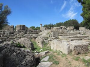
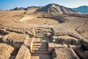
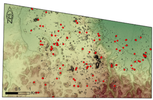
More than 400 large tumuli are dotted over much of the Isle of Pines with a concentration on the central so-called “Iron Plateau,” plus about 20 at particular locations in the south of the main island of New Caledonia. No systematic attempt has yet been made to locate tumuli elsewhere on the main island or, indeed, the other islands of the group. Early settlers assumed these were simply ancient burial mounds, but no graves, bones, pottery, charcoal, etc. have ever been found in them.

The locations of the tumuli generally appear to be quite random regardless of the terrain, although in a very few places a possible alignment or circle might be perceived in aerial images. More certain is the fact that most tumuli are rarely spaced less than 200 m apart, as geologist Jacques Avias noted in 1949.2 The tumuli average about 3 m in height with a circumference ranging between 15-25 m.3 While the majority of tumuli fall into this size range, a handful of oval shaped structures have also been described; one that was examined measured 3 m high and 16 m wide.4 

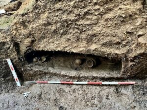
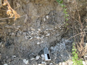
New investigations have revealed that as much lies beneath the tumuli as above; the mounds contain a large square or oblong core made of a high-grade concrete. The most detailed excavation to date of a tumulus was on the Isle of Pines in 1959, revealing a core almost 2.60 m tall and a substantial 1.8 m across. At several points along the height of the core it was encircled by rings of iron-oxide nodules.5 The oval-shaped tumulus noted earlier proved to have two concrete cores, each 2 m diameter, and placed 5 m apart.6 While the concrete cores so far examined appear to consist of homogenous material, the upper part of one of the Paita cores that was completely demolished contained irregular pockets of soil of varying sizes.7 With regard to the soil intrusions, excavation data remain too limited to draw any conclusions.

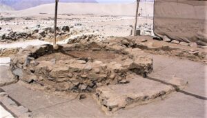
Most intriguingly, the Isle of Pines tumulus excavated by Chevalier in 1959 revealed that buried directly below the centre of the core was a symmetrical cone or top-shaped iron object, pointing down and surrounded by 3 rings of large iron nuggets. It was over 2 meters long.8 As will later be discussed, Chevalier’s excavations of two tumuli at Paita also revealed puzzling features below the concrete core. One of the tumuli completely demolished on Paita revealed a separate “vaguely circular” slab of cement beneath it, in the middle of which was a wide (90 cm) and deep (1.8 m) trench, oriented east-west, and two holes at different depths. The other Paita tumulus did not appear to have a comparable feature beneath the core.9

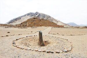
Another, most significant, feature was not noted until the excavations led by Jack Golson in 1959-1960: a circular, vertical, shaft running from the top of the core at its centre down to its base; this will be discussed further.

___________________________

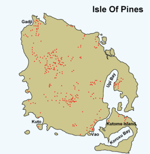
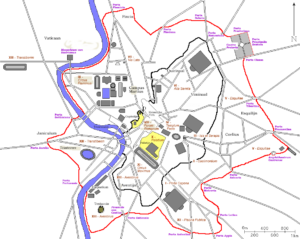
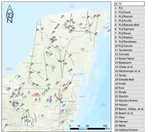
Figure 1: Known tumuli locations on the Isle of Pines (after D. Frimigacci, Notice explicative de la feuille Ile des Pins: Carte géologique à l’échelle, Paris: BRGM, 1986, 28). 

_______________________________

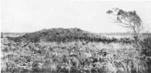
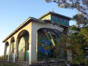
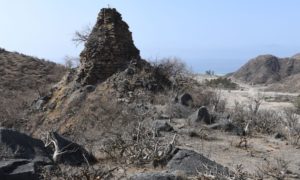
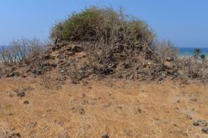
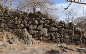
Figure 2A: One of hundreds of enigmatic “tumuli” on the Isle of Pines. This early photograph was published by R. H. Compton in 1917 and shows one of the rare double-cored mounds.

_________________________________

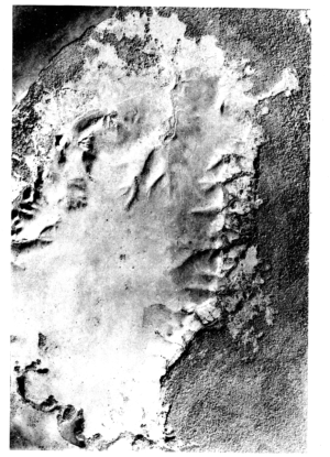
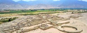
Figure 2B: A 1949 aerial view of the “Iron Plateau” of the Isle of Pines with scores of tumuli visible before reforestation of the area.

_________________________________

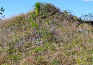
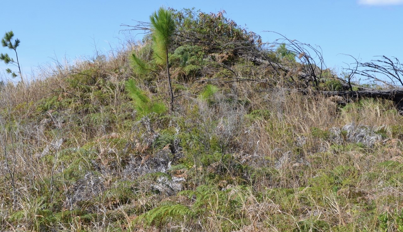
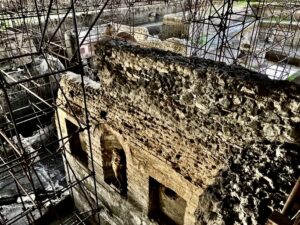
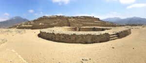
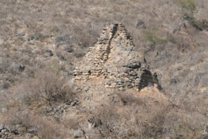
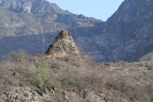
Figure 3: Today, hundreds of mounds lie in open land or in pine forests on the Isle of Pines. Photograph by the author, 2017. 

________________________________

MODERNS ENCOUNTER AN ENIGMA

Some of the underlying issues for some aspects of New Caledonian and, more generally, for South Pacific pre-history remaining in somewhat of a stalemate were discussed in Roger Green & J. S. Mitchell’s 1983 paper, “New Caledonian Culture History: A Review of the Archaeological Sequence,”10 The authors provide the following reasons: firstly, over the years research has appeared in a great range of venues and is seldom integrated. Secondly, not all  findings have been published in readily available sources (and sometimes not published at all); thirdly, a perceived language barrier as the main sources are [obviously] in French and English; finally, one of the primary sources (Gifford & Shutler, 1956) has some deficiencies in its presentation of data – something Green and Mitchel discuss – and investigators since have not followed a consistent terminology or frame of reference.

A chronological examination of the main sources reveals the long-standing confusion over how to account for the tumuli within the accepted time-frame of human arrival in New Caledonia, as well as the factors outlined by Green and Mitchell just noted. To examine even a brief history of modern sciences’ attempt to understand these structures is to encounter a spectrum of human foibles, ranging from honest reporting with rational analysis to degrees of disingenuity and, above all, avoidance.

Early observers on the Isle of Pines realized that these scattered mounds represented a mystery and were quick to seek answers. As early as 1897, Frenchman Theophile-Auguste Mialaret reported “opening” a tumulus, but finding nothing of interest.11 In 1917, Englishman R. H. Compton reported in The Geographical Journal the “remarkable” dome-shaped mounds of earth: “…excavation has revealed no contents of interest…various suggestions have been put forward to explain them.” In both cases their efforts were watched, as Compton noted, “without fear by the indigenous people who, while claiming that they did not make the tumuli, could give no explanation for their origin.” He concluded: “I am quite unable to offer any suggestion as to their origin myself.”12

The 1949 paper by Avias included an aerial photo (reproduced here as Figure 2B) showing “nearly two hundred” tumuli on the central “Iron Plateau.” He proposed a series of ancient arrivals in the southern Pacific, predating the Melanesians, concluding “…at least the following hypothesis can be put forward: a civilization …preceded the present Kanak civilization…this civilization had a Neolithic industry more advanced than the indigenous people.”13

That the structures contained a massive concrete core remained unsuspected and unknown until proper excavations on the Isle of Pines began in 1959. Leading the post-war vanguard of serious investigators were two archaeologists, Jack Golson and Luc Chevalier.                

From 1959-1960 British-born Australian archaeologist Jack Golson led a team excavating four “tumuli” on the Isle of Pines, finding that there were at least 3 types of structures. Golson’s team went on to map more than 120 mounds and excavated three of them. They viewed the concrete cores as “anchors” and established, by probing their centers, that “many” other mounds also had a cement core. As briefly noted earlier, their excavations revealed that at least several of the cores had a vertical hole running through them, a feature they termed “postholes,” but could not determine what function the shaft might serve.

Golson published a brief report in 1961, “Report on New Zealand, Western Polynesia, New Caledonia, and Fiji” concluding: “The mystery of the tumuli is thus, despite this spate of activity, as great as ever. Who were these concrete makers of New Caledonia and what is the function of their constructions? Native tradition is silent and the archaeologist as yet ignorant.”14 In 1963 he published more data from his expedition in “Rapport sur les fouilles effectuees a l’ile des Pins (Nouvelle Caledonie) de Decembre 1959 li Fevrier 1960” and with Daniel Frimigacci in 1986, “Tout Ce Que Vous Pouvez Savoir Sur Les Tumulus, Meme Si Vous Osez Le Demander,’’15 providing a comprehensive summary of the topic.              

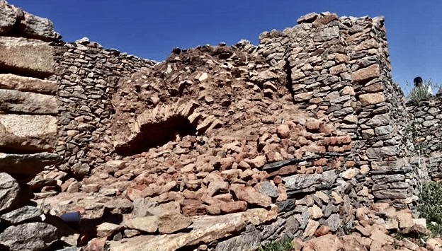
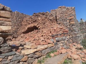
Luc Chevalier, the French archaeologist, was led by unexpected circumstances in September 1959 to shed further light on the tumuli. Based in Noumea as curator of the National Museum, Chevalier traveled to the Isle of Pines to investigate a report that local workers upgrading a road had encountered a solid white “rock” at the centre of a tumulus they were demolishing for road-building material. With a half-exposed mound as a starting point, Chevalier immediately began excavating until the southern side of the tumulus core was exposed and the unexpected object beneath it revealed. Chevalier describes it as an “iron oxide rock” about 2.40 m tall – almost as tall as the core itself – and a maximum diameter of 1.10 m, resembling a symmetrical upside-down “top” or cone, pointing down. At that point, the entire structure threatened to collapse; amid several small landslides excavation was halted. In 1963, Chevalier’s final report, “Le Probleme des Tumuli en Nouvelle-Caledonie” appeared in the Bulletin de la Societe des Etudes Melanesiennes;16  It deserves close reading.

________________________________

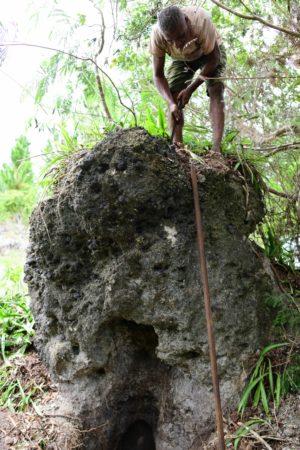
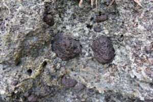
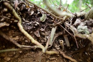
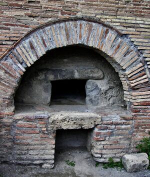
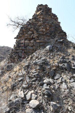
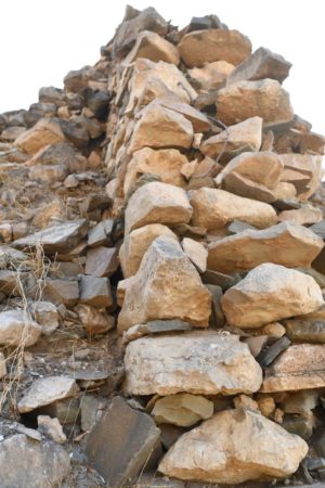
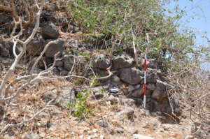
Figure 4A, 4B (2 images): The exposed 2 meter high concrete core from the tumulus excavated by Chevalier in 1959, with a close-up view of large iron nodules embedded in it. Photographs by the author, 2018.

_________________________________

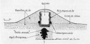
Figure 5: Chevalier’s 1963 excavation report (his Fig. 5) shows the interior of the mound after excavation. The rings of iron nodules and the top-shaped object buried beneath the central core are clearly shown.

_________________________________

Chevalier then examined other nearby tumuli on the Iron Plateau, determining that at least many of them also contained a central core made of “white mortar” and making particular note of the oval-shaped tumulus that contained two cores. Returning to Noumea, he then investigated several tumuli in the region of Paita just north of the capital. An identical situation to what had happened on the Isle of Pines involving road workers was replicated in Paita; this time uncovering two concrete-cored tumuli about 300 m apart. It was here that several intact Placostylus snail shells found embedded in the concrete matrix of the cores and were sent, with samples of the cement, to a laboratory in Paris for dating. His report shows images of the exposed concrete cores of 2 of the Paita tumuli being demolished.

Despite anticipating further excavations that would “verify the presence and shape of this [cone-shaped] stone under the other tumuli,”17 Chevalier’s next excavations at Paita would only raise more questions. Aside from the absence of any mention of Golson’s “post holes” in the concrete cores (about which Chevalier may not have been aware) in his reports, those he examined remained completely analogous to those in the Isle of Pines tumuli although, as noted earlier, the Paita cores had differing material beneath them and the cone-shaped object was not found in these part-excavations. Nor does Chevalier mention returning to the Isle of Pines, although he expressed optimism that a complete excavation campaign there would be possible the following year, ie. 1960.18

Among other significant aspects, Chevalier noted that on both the Isle of Pines and at Paita the excavations were culturally sterile; that is, no tools, pottery, charcoal etc. could be found. The closest thing to a cultural artifact was the apparent surplus of construction materials found near the two Paita tumuli excavated, a quantity of lime mortar mixed with silica near one and a 10 m wide elevation of silica gravel near the other. Both offered clear indications of human involvement likely, as Chevalier recorded, being the places where cement was prepared before being poured into the centre of the tumulus to form the core.19

He commented, “There is no doubt that the same people who made the tumuli on the Isle of Pines also made those in the region of Païta. The only difference between them is that the tumuli of Païta are made of a supply of silica present everywhere, while those on the Island of Pines used the “iron shot” which is found in abundance on the plateau….It is also necessary to determine the origin of most of the mortar: or is this the result of the calcination of coral?… it is curious to find no fragments of charcoal in the mortar. [It indicates] a space between the time of the construction of the tumuli and the pre-European Melanesian era.” The conclusion of his report, “Many Questions Without Answers,” summed up the facts:                                                                “The tumuli of New Caledonia are undoubtedly the result of an ancient human activity of which there is no trace in the local tradition.” Remember that the manufacture and use of lime was not known to the natives before the arrival of the missionaries in 1843. One is perplexed by the importance of the work done to erect these monuments. When one thinks that a tumulus represents on average, a volume of 200 m3 and that on the Isle of Pines alone there are more than 300 tumuli, requiring a very large workforce. However, this workforce during its work, had to leave some traces of its passage, its life, its activities …to date, no trace, no evidence, no vestige, either inside or outside the tumulus has been found.”

Chevalier closed with the following, very perceptive, observation:

“…a final question arises in our mind: the builders of these tumuli knew perfectly the principle of manufacturing and using the mortar for the erection of the cylinder. Why did they not use this knowledge for other works, other realizations, their dwellings, for example…? Would they have reserved this knowledge only for the tumuli, conferring to these monuments a particular character, even a sacred one?” 

Had more attention been given to these questions by those who came after Luc Chevalier, our understanding of these structures would have advanced more rapidly than it has and without the avoidance of facts and obfuscation in so much of the commentary since then.

DATING

The results of two chemical analyses of the components of the concrete (one from the Isle of Pines, one from a Paita tumulus) appeared in Chevalier’s 1963 report and are quite comparable; the primary disparity evident in the Fe and Si amounts reflecting the two very different environments of origin. The dating of the mortar and snail shells from a core excavated on Paita by Chevalier was published in a 1966 paper in Radiocarbon. This gave radiocarbon dates for surface and interior mortar (7070 ± 350 and 9600 ± 400 BP respectively), plus a date for Placostylus snail shells on the surface of a cylinder (12,900 ± 450 BP). Echoing Chevalier’s belief that the tumuli “testify to an important human activity completely extinct today…” the report’s authors noted that if the cores were really man-made “…they are by far the most ancient mortars known.”20 Radiocarbon dating by others since have served to confirm Chevalier’s very early dates. For example, a 1972 dating of tumulus cement yielded ages ranging from 4120 ± 90 to 7710 ± 70 BP.21

Space constraints prevent a full review here of those who have accepted this dating, but they include scholars such as Brookfield & Hart in 1971,22 Fr. Marie-Joseph Dubois (1976),23 Richard Shutler Jr. (1978),24 Peter Bellwood (1978),25 Roger Green & J. S. Mitchell (1983),26 Kerry Ross Howe (1984),27 John R. H. Gibbons & Fergus G. A. U. Clunie (1986),28 Christophe Sand (1999)29 and Patrick V. Kirch (2000 and 2017).30 

It is an understatement to say that the disconnect between the Placostylus and mortar dating  and the conventional understanding of human settlement in the Pacific is unbridgeable. To contemplate people arriving in New Caledonia as early as 12,000 years ago simply cannot be massaged into the accepted scenario. Consequently, many – perhaps most – of these researchers believed that the extraordinarily early snail shell dating had probably been of much earlier material, thus allowing for the actual tumulus construction to have taken place perhaps in the Lapita period, roughly 1500 to 500 BC. Other commentators simply ignored these data. No-one seems to have asked how multiple fragile snail shells survived intact for many thousands of years before finding their way onto the outside of a block of drying cement, for the shells were found on the surface of the cement, not in its interior. One shell can be clearly seen in Fig. 14 of Chevalier’s report.

EXOTIC EXPLANATIONS 1949>

Unsurprisingly, the inability of archaeology over many years to provide resolution as to the origins of the tumuli led to several proposals far from main-stream thinking. This began as early as 1949 with the “working hypothesis” of Jacques Avias already noted. After attempting in vain to locate patterns in the placement of the tumuli and any correspondences to the southern constellations Avias broadened his studies to all other traces from the past, such as petroglyphs and pottery styles across New Caledonia. His paper offered suggestions that a Neolithic culture predating the present Kanak civilization may have been influenced by, or even originated in, certain Eastern cultures, specifically the Chinese and Japanese. He developed an earlier thought expressed by P. Rivet in 1931 that from Japan the Ainu may have explored the Pacific islands.31 While not subscribing to such views themselves, Daniel Frimigaccci and Jack Golson also mentioned that the “most extreme hypotheses were advanced to explain their presence [the tumuli],” noting in particular “extraterrestrials or mysterious populations now extinct practicing stellar-solar rites.”32

One of the great ironies is that attempts to explain the tumuli by invoking incursions by distant explorers, inhabitants of the legendary continents of Mu, Atlantis or the Aroi Sun Kingdom,33 or extraterrestrials,34 now appear somewhat less fanciful than they once seemed, especially when more prosaic explanations are compared. This is no more so than the avian theory to be discussed next.

THE “AVIAN” THEORY 1985>

In late 1985, after bones of an extinct Megapode bird species were found in New Caledonia, Cecile Mourer-Chauvire & Francois Poplin published “Le Mystere de Tumulus de Nouvelle-Caledonie,”35 proposing that these birds may have formed each tumulus by scraping the ferritic soil into a giant mound in which the eggs could be deposited and incubated until hatched. Left unexplained was how this process somehow produced a massive, linear, block of cement in the interior, with a hole running through it and, in at least one case, a large cone-shaped iron structure buried directly below that. They concluded that “the giant bird hypothesis is just as reasonable as the theory that these mounds were built by ancient humans who knew how to make cement.” 

______________________________

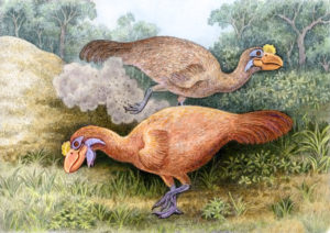
Figure 6: The conjectured formation of the tumuli by the large extinct bird Sylviornis neocaledoniae, seen here scraping soil into a mound for nesting.

____________________________________

From this quite cautious proposal, the idea caught hold. Notably, since his 1983 co-authored paper listed earlier, archaeologist Roger Green came to accept this naturalistic explanation for the mounds as outlined in his influential 1988 article, “Those mysterious mounds are for the birds.”36 Green’s article gives good background of how the Megapode theory was first pressed into service to explain the mounds. That redeeming feature aside, the reader needs to take some giant leaps of faith: the concrete cores are explained away as the wholly natural action of microorganisms, tiny globules of calcite in the soil somehow binding rocks and debris together. Later on, it was proposed that the nesting birds also introduced vegetation into the mounds which decayed, providing heat for the eggs. Subsequently, a refinement of the theory proposed that the Megapode tidily excreted into the hole in the top of the mound, the faeces becoming the heating agent for the eggs. Over time, the droppings are presumed to have fossilized and become the “cement” found today.

The Megapode theory failed to account for what qualified archaeologists actually found in the tumuli: the components of the concrete and the iron artifacts around and beneath the core. It typically did not concern its proponents that no trace of bird shell or other material that would normally indicate an avian presence had been found.

Of course, not all scholars accepted the avian theory. Some indicated their tacit acceptance of an anthropic origin for the tumuli, sometimes in regard to the political implications any notion of pre-Melanesian settlement presents. See, for example, John Connell, “New Caledonia or Kanaky? The political history of a French colony.37 Others remained open to a human origin for the tumuli without taking a firm position pro et con. A 1995 paper by Janelle Stevenson & John R. Dodson was open to earlier arrivals, noting the evidence for human occupation 28,000 years ago on Buka Island in the nearby Solomons. They noted the divided opinions on the mounds, stating that “no cultural material or bird remains” had been found, but avoided any direct mention of the cores.38 In 1999, Stevenson noted that human arrivals earlier than the Lapita culture (ca. 3200 years ago), would remain speculative “…as long as a human origin for the so-called tumuli of New Caledonia is entertained…” referencing a paper by Christophe Sand.39 

A 1997 review by Patrick V. Kirch of three 1995 publications by Christophe Sand (until 2019 Director of the Institute of Archaeology of New Caledonia and the Pacific in Noumea), critiqued the multiple earlier scholars whose analysis of data suggested the “specter” of an aceramic, cultural, origin. Sand’s publications were also criticized for not adequately discussing the Megapode theory.40  Kirch essentially maintained his pro-avian position throughout his 2000 book On the Road of the Winds – An Archaeological History of the Pacific Islands Before European Contact. It was republished in revised form in 2017, but while he accepted tumuli dating as early as “10,950 BC” it continued the inaccurate (and unreferenced) assertion that “egg shell” had been found in “the mounds.”41

The avian theory continued to be uncritically accepted when it reinforced more general positions. A representative statement from anthropologist Susan O’Connor argued in 2010 against the 1986 Gibbons & Clunie proposal for Pleistocene voyaging between the eastern edge of the Australian continent and New Caledonia. Their two primary arguments for the voyaging rested on the reduced distances needed for ocean crossings when sea levels were lower and the reported human derivation of a series of ‘tumuli’ or artificial mounds on the interior plateau of the Isle of Pines. O’Connor’s comment regarding the tumuli was that they dated to c. 12,000 BP, [and] have been shown as built by megapodes.”42

Beginning as a well-intentioned attempt at explanation, for many the “megapode” theory became a convenience to avoid dealing with the possibility of a pre-Lapita human presence. But it was a fiction all the same. After all, the actual components of the cement cores have been known since Golson and Chevalier’s work was published and, along with other items we would expect if birds were involved, neither Phosphorous nor any fragments of egg shells have been found in the tumuli.

The avian theory was dealt its final fatal blow on 30 March 2016 with publication of a paper by Trevor H. Worthy et al. titled “Osteology Supports a Stem-Galliform Affinity for the Giant Extinct Flightless Bird Sylviornis neocaledoniae (Sylviornithidae, Galloanseres),” in PLOS ONE.43 Significantly, Christophe Sand was a co-author. Page 53 of the paper discusses the avian explanation for the tumuli (all emphasis added):

Sylviornis neocaledoniae has been identified as a possible maker of large mounds or tumulion La Grande Terre and Ile des Pins. However, there is no evidence of association of this species with these mounds and eggshell has not been found in them, despite the calcareous nature of at least those on Ile des Pins. 

Given that our analyses show that S. neocaledoniae has no enhanced morphological adaptations for digging, such as those displayed by certain megapodes, it is most unlikely that it is responsible for these tumuli.

Instead these tumuli are likely to be formed by an interplay of vegetation and erosion as suggested for similar mounds elsewhere. Even if mounds were associated with eggshell, then the largest of all Megapodius species, the New Caledonian endemic and extinct M. molistructor Balouet and Olson, 1989 would be a more likely contender for their builder.

The paper concluded as follows (incidentally validating the comments made by Golson44 in 1963 about the extinct bird under discussion):

Our finding that it is a stem galliform (and thus not a megapode) makes it most unlikely to have been a mound-builder, as this scenario would require both mound-building and ectothermic incubation to have evolved twice. Furthermore, Sylviornis neocaledoniae shows no specific adaptation for digging to facilitate mound-building, unlike all extant megapodiids, making it even more unlikely that it exhibited ectothermic incubation.

THE “ENVIRONMENTAL” THEORY 2016>

Buried within the text reproduced above lay the author’s replacement theory to explain the tumuli:                          

Instead these tumuli are likely to be formed by an interplay of vegetation and erosion as suggested for similar mounds elsewhere. (emphasis added).

_________________________________

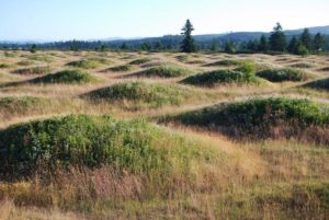
Figure 7A, 7B (2 images): A view showing so-called “mima-like mounds” and a graphic illustrating two hypothesized erosion scenarios resulting in the formation of mima-like mounds. Graphic kindly provided by Nathalie Diaz, University of Lausanne.  https://www.researchgate.net/publication/295858365_Can_mima-like_mounds_be_Vertisol_relics_Far_North_Region_of_Cameroon_Chad_Basin.    https://www.researchgate.net/publication/296795029_Can_mima-like_mounds_be_Vertisol_relics_Far_North_Region_of_Cameroon_Chad_Basin/figures?lo=1  

_________________________________

_________________________________

Thus, what could be termed the “Environmental theory” was introduced. In essence, it proposes that “calcite concretion” may have developed around the root complex of a long rotted tree, leading to “differential erosion” in the landscape. Such structures are variously known by names such as “mima-like mounds” or “heuweltjie earth mounds” and are found in various environments around the world. However, an examination of this phenomenon (including sources cited in notes 83-85) reveals stark differences between such formations and the tumuli. They are utterly unlike the tumuli under discussion in this paper. Not only do the former have smaller dimensions, but these formations lack the tumuli’s central concrete pillar, not to mention its central shaft and iron appendages. The suggestion is perhaps even less plausible than the avian theory it replaces.

THE “BURIAL” THEORY 2017>

In 2008, an important development began with publication by Frederique Valentin & Christophe Sand of a paper, “Prehistoric Burials from New Caledonia (Southern Melanesia): A Review.”45 The paper included a detailed description of the Tüü mound on the Isle of Pines excavated by Daniel Frimigacci, noting that the Tüü mound likely had original dimensions approximating the concrete-cored tumuli, but its interior was taken up with 3 levels of human burials; a base level of loose bones, with 2 higher levels each containing a full human skeleton. Dating of the bones yielded a range between 1930 and 1845 BP and appeared to be primary, original, interments. The salient points of the text follow (all emphasis added):

The study revealed two stratigraphic levels containing interments (Frimigacci, 1979, pers. comm. 2000). The lower level, above a basal level dated to 1930+/–70 BP (UW 655, calibrated A.D. 50 (80) 245), contained at least one complete adult skeleton, dated to 1440 +/– 35 BP (UW 766, calibrated A.D. 560 (635) 660). The body was on its right side, apparently in a hyperflexed position, knees against the chest (Frimigacci, 1979:22, figure 15).

The second level contained a complete skeleton of a male about 40 years old (Charpin, 1983). It was on its back in extension.

The surface level included many disarticulated and scattered human bones that Frimigacci (1979) regards as representing incomplete skeletons. A bone sample returned the early date of 1845 +/– 65 BP (UW 765, calibrated A.D. 30 (160) 370).

According to Frimigacci (1979: 21), “ce tertre funéraire est une sépulture collective, il a été édifié au fur et à mesure des inhumations” [the funeral mound is a collective grave which was built up by successive inhumations]…..The inhumations were apparently primary and definitive, displaying variations in positional modes and an expansion of the tumulus by addition of sedimentary levels.

By including this description and dating for a prehistoric burial on the Isle of Pines, the straightforward report effectively again differentiated burial mounds from the concrete-cored tumuli (which were left unmentioned throughout the paper). Surprisingly, this very description became the linchpin of another theory in 2017 when Louis Lagarde published his paper, ““Were those mysterious mounds really for the birds?46 It is probably the most important study of the tumuli published since Chevaliers 1963 report.

Positioning itself, in part at least, as a response to Roger Green’s influential argument in support of the avian theory, the paper reviews the history of scientific enquiry into the tumuli, giving particular credit to the pioneering work of Daniel Frimigacci in mapping tumuli in the 1970’s and also exploring the coastal burial mounds such as the one at Tüü. It then maps the avian hypothesis in some detail, as well as various earlier attempts to explain the tumuli geologically. Results of the 2006-2010 survey led by Lagarde, some never previously published, then serve to demonstrate why the tumuli must have an anthropic origin.

For all this material we can be grateful, but despite it the report works up to a most unexpected detour, for notwithstanding the long-published excavation reports and the author’s own wide-ranging experiences, the report then proposes that the burial mounds are essentially the same as the tumuli, only the construction material varying according to the location. The detour is first introduced by mentioning an oral tradition claimed by a local informant mentioning that “posts were planted on the top of earth mounds and scenes of “torture.” This claim had been reported in 1986 by Frimigacci and Golson,47 and while Lagarde rightly warns about placing too much weight upon it, he nevertheless uses it to introduce his primary conclusion in the paragraph that immediately follows.

In this next discussion, Evidence of funerary practices, the dating of a burial mound in Gadji  to ca. 2309-2003 and 2208 BP is described as “similar” to the Tüü first century AD dating; on that basis the plateau tumuli are then declared to have the same ritual, funerary, function as the earth mound burials. This stunning claim completely ignores the various carbon-dating results and, as we shall see, the uncontested facts established in tumuli excavations. Lagarde is careful to first note a fundamental difference between the burial mounds and the tumuli (one has burials, the other does not), but then introduces the perplexing claim that the tumuli are void of any “archaeological material”:

Given this [dating] data, it seems legitimate to suggest a new interpretation as funerary structures for the earth mounds. One major difference separates the plateau structures from the coral plain ones: in the plateau tumuli, no evidence of archaeological material is to be found, whereas every open tumulus of the limestone environment (through Frimigacci’s or our more recent fieldwork) seems to contain human remains (Frimigacci 1986: 29).

More such claims follow:

…after sixty years of archaeological activity on Isle of Pines, the hypothesis of an ancient human settlement that would predate Lapita by thousands of years should be abandoned. Every dig and survey campaign has only brought back evidence of material culture in connection with already known assemblages from mainland New Caledonia and its global, well-known, diverse cultural traditions of the last three millennia.

it has been impossible to discover any kind of artifact that would indicate a pre-Lapita culture, on Grande Terre or the Loyalty islands. The same goes for Isle of Pines, where no evidence of any culture that would pre-date Lapita has ever been found, after our four-year research campaign.

This hypothesis forces to unite both types of tumuli in the same function, despite the lack of archaeological evidence coming from the plateau ones. This is however very much in phase with the results obtained by Frimigacci. The plateau earth mounds and those of the calcareous seashore plain, are structurally and morphologically identical, their differences coming only from the environment in which they were erected.

Typologically, they are identical and linguistically, the people of Isle of Pines call both kinds purè: furthermore they stand in similar proportions in a population/space ratio, as hundreds of them are to be found in both chrome and coral environments. If one of the types was much rarer, if language could differentiate the structures, if the inner structure of the earth mounds was indeed typologically different, we would have separated the tumuli into two categories. On the contrary, we stand confident with the hypothesis of a unique anthropogenic tradition in which minor differences are to be explained by the surrounding environment.

This is not our idea, as Frimigacci was the first to point out the similarities existing between the two populations of tumuli, and to try to explain the use of the plateau ones by the contents of the seashore ones (Frimigacci 1986:32). His archaeological excavation of the human remains in the Tüu tumulus is for us the key finding of the past sixty years.

Arguing at some length that human bones can completely vanish under conditions of soil acidity and exposure to the elements via the “tiny limestone blocks” covering the tumuli, Lagarde concludes:

  …we suggest the possibility that the tumuli are of anthropic origin, bear a ritual/funerary function and that at least some of them were used as funerary mounds for primary burials.

We hope to have brought forward that the tumuli of the Isle of Pines are more archaeologically complex than straightforward, natural, bird-made structures. Although being the last pieces of evidence that could have supported the theory of a extremely ancient human settlement of the New Caledonian archipelago, they actually belong to the recent three millennia of Austronesian presence. In our opinion, they illustrate, at least partly, the funerary practices of a time span of five to six centuries, between the end of the first millennium BC and the first centuries AD.

How can we reconcile the fact that the interiors of the burial mounds and the tumuli are, in truth, actually radically different? What can account for such a disconnect between the uncontested archaeological evidence and such explanations as this report offers? Are we seeing the rise of a new default position to replace the discredited avian theory? If so, then as with all the other attempts at explanation the tumuli it comes at the expense of the archaeological evidence. As at the time of writing such questions remain unresolved.48      

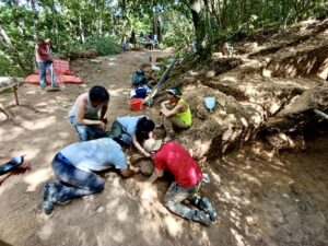
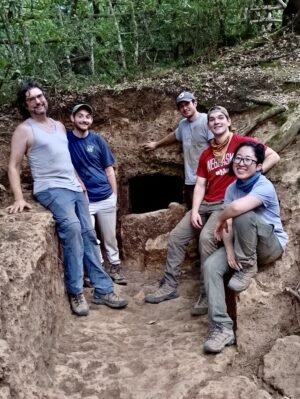
NEW INVESTIGATIONS FROM 2017

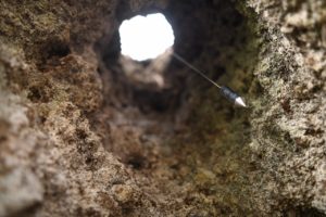
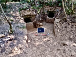
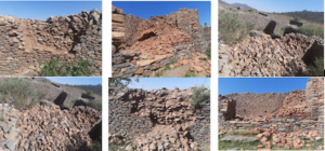
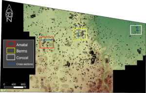
The author’s explorations on the Isle of Pines commenced in 2017 and first undertook a detailed examination of the original tumulus excavated by Chevalier. This was to reveal that this concrete core had a circular vertical shaft throughout its length. As Chevalier’s excavation report did not mention such a significant feature this unanticipated find was initially perplexing, but it was concluded that his excavation had not cleared the entire summit of the tumulus before work was abruptly halted. Thus, the opening at the very centre of the top of the core—1 foot/30 cm in diameter—was missed by him. After Chevalier returned to the main island, local workers continued removing the mound’s iron gravel as a source of road-making material until only the concrete core remained but the shaft would have been of little interest even if noticed. In fact, as already noted, Jack Golson’s 1959-1960 survey reports had mentioned this feature in many of the tumuli he and his team had examined. In his notes, Golson designated the concrete cores as “anchors” and the shafts as “postholes,” but could not suggest what purpose the latter served.49 

_____________________________

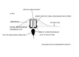
Figure 8: Chevalier’s 1963 excavation report (see Fig. 5) redrawn with the circular shaft in the concrete core added.

_____________________________

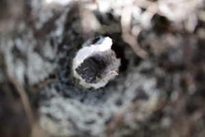
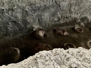
Figure 9A, 9B (2 images): Views looking down and up showing the 30 cm wide circular shaft running vertically through the middle of the concrete core of the tumulus excavated by Chevalier in 1959. Photographs by the author 2018, 2020.

_____________________________

THE CEMENT ANALYSIS UPDATED

From abundant large excavation debris still surrounding the tumulus, the author obtained samples of the interior concrete and submitted them for elemental composition analysis in an Australian laboratory.50  Following is a comparison of the results from Chevalier’s analysis of the first tumulus excavated on the Isle of Pines with the author’s 2018 analysis of the same structure, of the interior mortar in both cases:

    Chevalier Analysis/Author Analysis

Loss on ignition % 33.20 41.8                         

Fe2O3 26.57 6.6

Fe     18.60       nil recorded

Al2O3     4.00 0.4

CaO 34.25   48.2

MgO traces 0.7

SiO2   1.80       < 0.05

SO3 not recorded 0.1

MgO not recorded 0.7

K2O not recorded 0.03

Na2O not recorded       < 0.05

P2O5 not recorded       < 0.05

TiO2 not recorded         < 0.05

Mn2O3 not recorded 0.08

SrO not recorded 0.1

Cl not recorded   0.011

A REVISED CONSTRUCTION SEQUENCE

A construction sequence can now be proposed that incorporates all the features of the tumuli now known. It is based upon Luc Chevalier’s 1963 proposal for how the cement core was built on the Isle of Pines, but substantially expands and updates it.

____________________________

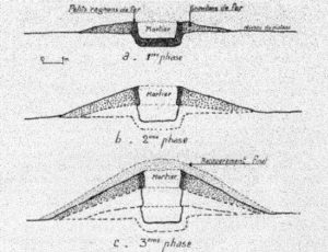
Figure 10: Construction sequence of the cement core on the Isle of Pines as proposed by Chevalier, 1963 [his note 6].

_______________________________

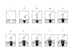
Figure 11: Author’s proposed construction sequence in cross-section, incorporating all known features.

_________________________________

Stage 1

The necessary first step required excavation of a hole through the topsoil and more than 2 meters deep into the ferruginous clay layer beneath.

Stage 2

This was followed by placement in the hole of the almost 8 foot/2.4 meters long Fe cone-shaped object, its point downwards and with at least 3 rings of Fe nuggets placed around it, perhaps to stabilize it in a vertical position. Their presence, incidentally, makes it clear that the cone-shaped object is not an artifact from iron being leached from the surface and somehow precipitating into a geometrical shape below the tumulus.

Stage 3A

Vertical placement of a tubular pillar or “pylon” (a smooth tree trunk?) of unknown length centered above the cone. Current excavation data lacks the resolution to determine which of these two possibilities is correct: (A) the pylon may have been placed in direct contact with the rounded top of the cone, or:

Stage 3B

  1. the pylon may have been separated from the top of the cone by a shallow bed of Fe nodules and soil, the scenario utilized in this model.

Stage 4

Over a bed of medium-sized Fe nodules, the first cement layer was poured into the hole, thus stabilizing the pylon in position. At ground level the base of the cement block was surrounded (delineated?) by large Fe nodules, while a circular base layer of Fe gravel was added around the cement core to the same height.

Local materials, consisting primarily of iron gravel but inevitably also some soil, were scraped up in a circular fashion around the structure, thus differentiating the scraped area from the normal surroundings, creating the “aureole” effect still visible in aerial images, as Chevalier noted. Throughout its erection, the outside surface of the cement core was reinforced with various sized Fe nodules, in contrast to the softer cement interior.

Stage 5

The second layer of cement was added, maintaining the same dimensions as the first layer. Likewise, the Fe gravel was built up around the core to the same level.

Stage 6

The third and final layer of cement was added, maintaining the same dimensions and the Fe gravel built up around the core to the same level.

Stage 7

A final, substantial, layer of Fe gravel was added to entirely cover the cement core, completing the rounded shape of the tumulus. The small size and particularly the weight of the gravel is such that it would have rapidly filled the hole in the cement core, assuring us that the pylon, or at least a “cap” of some type, was in place when the gravel covering was added to the tumulus. The simplest explanation is that the pylon remained in place throughout.

Stage 8

It is unclear whether a final, thin, layer of soil was added to cover the entire tumulus or whether the soil already mixed in with the gravel sufficed. In either event, the tumulus was now complete with only the pylon protruding from the hole in the cement block.

Stage 9

At some point the pylon was removed (or if organic, such as a tree trunk, perhaps rotted away) and the tumulus assumed its innocuous modern appearance, giving no hint of the substantial cement and iron structures within and below it.

At most tumuli in the present, the vertical hole in the cement core is covered over by the vegetation growing in the tumulus covering; for that reason, the hole was not readily visible to early investigators. Data are currently insufficient to ascertain whether the shafts became clogged with debris after removal of the pylon. While apparently intended to provide additional stability and strength, the very substantial covering of iron gravel and soil also effectively served to protect the tumuli from weathering and disguised their nature until very recent times.51 

THE FUNCTION OF THE TUMULI

Of the numerous reasons for building any structure elevated above its surrounds (to provide a higher vantage point, to elevate something for increased visibility, to use gravity to move something (eg. water) downwards, to funnel something (eg. smoke) upwards and so on), only a small number are potentially applicable to the tumuli. These are as follows:

1. A burial site. As demonstrated earlier, whatever else they may be, the structures are manifestly not burial mounds. No skeletal material, or the cultural artifacts associated with burials, have yet been observed in the concrete-cored tumuli. Human burials, of course, are found in a variety of mounds or sub-surface sites that do not resemble in any way the structures under discussion here. The human burial mounds are smaller in height and extent, have no cement core at their centre and are generally found in situations and locales more commonly associated with funeral remains.

Purely as a note of interest, in 2019 the author and others examined a large concrete-cored tumulus on private land at Gadji which had been disturbed by road construction; a small number of loose human bones were located just beneath the surface (a depth of ca. 15 cm), an act of later, accretional, burial using the surface of the mound as a convenience. Here, in a classic situation of an apparent exception proving the rule, the obviously recent very shallow burial helps emphasize that these structures were not originally intended to inter human remains, a distinction readily apparent to most observers over the years.52

_____________________________

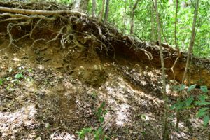
Figure 12A, 12B (2 images): The relatively recent burial just below the surface of a large tumulus in Gadji. The damaged concrete core in the centre of the tumulus and the burial location on the right side are both visible in image 12A. Images by author, 2018.

________________________________

2. As an elevated vantage point or watchtower. This proposal lacks any merit as abundant opportunities for higher views are afforded by adjacent land features and trees. And, in any case, it does not explain the cement core construction and the sheer number of tumuli built.

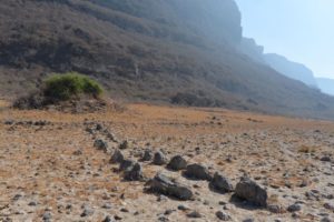
3. As a ceremonial or ritual centre. This concept finds some support in a handful of locations where rock-lined paths and other cultural indicators have been found. Most recently, the 2006-2010 survey on the Isle of Pines identified pathways, depressions and large ferralitic boulders atop 6 tumuli. While ceramic sherds remained “extremely rare” on the Iron Plateau, indications of eaten seashells from the coast or “fossil uplifted limestone blocks from the forest” were noted at 8 tumuli.53 Investigation is still required to determine if these works are contemporaneous with the tumulus, or a later expansion by others. Logically, the likelihood that the stones date to a much later period seems to be strengthened by their rarity. 

The oral tradition noted earlier that mentioned that “posts were planted on the top of earth mounds and scenes of “torture”” does not offer support for ritual use any more than it does for a funerary function; a post or tree trunk does not require a large concrete base to ensure it stands upright. If these traditions have any substance they must refer to a usage postdating the tumuli construction.

4. As an artistic expression. The most obvious objection to the structures being an art form that developed uniquely in the area, is that their most impressive features – the interior cement block surrounded by iron nodules – was completely covered over with earth and clearly not intended to be visible. Nor would a circular earthen mound require such an interior, one that remained unseen. We would expect that an object of art would be adorned with other features, either individualistic or symbols common to the community. Instead, with the exception of the few locations noted in #3, we find only conformity, an austere plainness that suggests a strictly utilitarian, functional, purpose, not an artistic one.

A NEW PROPOSAL

By showing what the tumuli are not and cannot be, the purpose of these structures can now be proposed with some certainty. From an engineering viewpoint the large cement blocks within the tumuli have the primary purpose of stabilizing a circular pillar or pylon, standing in the vertical shaft of the core but later removed or decomposed, for no trace of them now remains.Nor is there any hint of what the pillar/pylon may have supported and why it  required such a degree of stabilization, as evidenced by the massive cement base. Determining this is now the challenge going forward. Ascertaining the function of the cone-shaped metal object beneath the shaft may offer the most promising line of future investigation.

Nothing to date suggests that the tumuli construction took place over an extended period where we would expect to see improvisations or the development of different styles. Everything suggests a one-time concentrated effort.

Only two of the Paita tumuli preserve any trace – surplus raw material – of the construction process and, just possibly, of a stage of early experimentation with local materials. If so, we can speculate that the silica-based process may have been abandoned in favor of the iron resources readily available on the Isle of Pines.

CONCLUDING REMARKS

More answers will reveal themselves when modern archaeologists engage more fully with the structures than they have heretofore. It would require little effort to completely reveal the interiors of those structures that are already partly and even fully exposed; in particular, the large cone-shaped iron structure which is the most likely feature to fully reveal the final answers to the mystery. Was this a type of anchor, such as our modern anchor spears, for the pylon or pillar sitting directly above? While this artifact has only been reported from one site, it beggars belief to think that Chevalier chanced upon the one tumulus that had a symmetrical cone-shaped metal object positioned exactly below the shaft in the central core; it must be an integral part of other tumuli. For that matter, we cannot be sure that nothing else lies beneath the cone itself – no-one has looked.

The incongruity of the scientific establishment, particularly archaeologists and historians, in having Chevalier’s excavation reports since 1963 while still proposing solutions that do not, in any way, account for what lies within these structures is staggering. The tumuli, after all, remain readily available for examination. This inaction must represent, in large part at least, the instinctive avoidance of something that challenges present paradigms about human settlement in the southern Pacific.

Surely the time is long past when data seemingly at odds with our current thinking are ignored. Perhaps in them lies a key to a broader understanding of what influences and events have shaped the Pacific’s distant past even if, as the data in his paper suggests, it requires a reconsideration of what we can possibly term the “Neolithic” explanation. It is hoped that this paper will encourage archaeologists and historians of this region to re-engage with facts and move beyond demonstrably inadequate theories in solving the puzzle these structures still represent.

In the 21st century, the enigma remains. And if Chevalier’s questions were perceptive in 1963, decades later they can be re-stated and expanded:

The identity of the tumuli builders remains, of course, the crux of the mystery, but they certainly predated the arrival of the Melanesians who became the generally regarded indigenous culture and had no ability to manufacture concrete. Who were they? Where did their ability to make high-quality concrete come from at a time when this technology was unknown, certainly in the Pacific at least?

What possible motivation or purpose could cause a people to invest so much effort to erect more than 400 of these structures, each averaging a volume of 500 cubic meters?54   

Why did such a massive effort leave no other traces of its life and activities—no tools, bones, charcoal, pottery or other cultural artifacts, either within the tumulus or around it?

Why did they not use this ability to construct other works, their dwellings, their burials and their sacred places before, during, or after the tumuli construction?

Over time, why was the ability to manufacture such a useful material as concrete not exported to other islands? Why was this capacity not passed down to the Melanesians who became the generally regarded indigenous culture? Indeed, why did this capacity not arise elsewhere in the region?

The prescient questions of Chevalier, pondering the mystery of a distant, unknown, people who knew how to make durable concrete on a large scale, still await resolution.

END

_____________________________

Conflicts of Interest

None.

_____________________________

About the Author

Warren Aston is an independent researcher based in Brisbane, Australia. He studied archaeology at the University of Queensland, and has been involved in archaeological projects in Mexico and Oman over several decades. He can be reached at: astonwarren@hotmail.com 


_____________________________

NOTES

1.“The [Isle of Pines] is considered to be a kind of “archaeological nightmare” due to the presence of no less than 200 earth mounds…” Louis Lagarde & Andre-John Ouetcho, “Rocks, pottery and bird bones: new evidence on the material culture of Isle of Pines (New Caledonia) during its 3000-year-long chronology,” in Christophe Sand et al. eds. The Lapita Cultural Complex in time and space: expansion routes, chronologies and typologies (Noumea: IANCP, 2015), Archeologia Pasifika 4 series. https://www.researchgate.net/publication/280976124_Rocks_pottery_and_bird_bones_new_evidence_on_the_material_culture_of_Isle_of_Pines_during_its_3000-year-long_chronology

2. Jacques Avias, “Contribution a la Prehistoire de L’Oceanie: les Tumuli des Plateaux de Fer en Nouvelle-Caledonie” in Journal de la Societe des Oceanistes (1949), 15-50 (author transl.) Emphasis added. https://www.persee.fr/doc/jso_0300-953x_1949_num_5_5_1625

3. Louis Lagarde, “Geological anomalies?” in ““Were those mysterious mounds really for the birds?” Reappraising the Isle of Pines’ puzzling tumuli (New Caledonia)” in For a history of Oceanian prehistory: historiographical approaches to French-speaking archeology in the Pacific (Noumea: Pacific CREDO publications, 2017). Emphasis added.

4. Luc Chevalier, “Le problème des tumuli en Nouvelle-Calédonie,”Bulletin périodique de la Société des Études mélanésiennes 14-17 (Noumea: Société des Études mélanésiennes, 1963), 24-42. Emphasis added. www.archeologie.nc/docus/tumulcheval.pdf. The section titled “Tumulus A Cylindre Double” reports the examination of an oval double-cored tumulus and notes two others visible in aerial images.                                                                          Three related reports by Chevalier are also on file at the New Caledonia Museum in Noumea: “Observations faites sur un tumulus ouvert a LIIe des Pins” (3 pages) dated October 6, 1959; “Note sur les tumuli de Nouvelle-Caledonie” (3 pages dated October 21, 1960 regarding the mortar analysis) and a 5 page handwritten draft dated January 15, 1961 of the article that would appear in 1963.

5. Chevalier (1963), Figs. 4, 5. 

6. Chevalier (1963). See Fig. 7 sketch in “Tumulus A Cylindre Double.”

7. Chevalier (1963), Fig.10.

8. Chevalier (1963), Fig. 5.

9. See Chevalier (1963) Figs.10 and 11 with notes.

10. Roger Curtis Green & J. S. Mitchell, “New Caledonian Culture History: A Review of the Archaeological Sequence” in New Zealand Journal of Archaeology vol. 5 (1983), 19-68. Emphasis added.

11. Theophile Auguste Mialaret, L’île des Pins, son passé, son présent, son avenir: colonisation & ressources agricoles (Paris, J. André, 1897). Reprinted in 2012 (Paris: Hachette Livre BNF). Emphasis added.

12. R. H. Compton, “New Caledonia and the Isle of Pines,” The Geographical Journal vol. 49, no. 2 (London: Feb. 1917), 81-103, esp. 102-103. Emphasis added. https://www.jstor.org/stable/1779337 

13. Jacques Avias (1949), 15-50. Emphasis added.

14. Jack Golson, “The Tumuli of New Caledonia” in “Report on New Zealand, Western Polynesia, New Caledonia, and Fiji,” Asian Perspectives vol. 5, no. 2 (Winter, 1961), 170-172.

15. Jack Golson, “Rapport sur les fouilles effectuees a l’ile des Pins (Nouvelle Caledonie) de Decembre 1959 li Fevrier 1960,” in Bulletin périodique de la Société des Études mélanésiennes N.S. 14-17 (1963), 11-24; Daniel Frimigacci & Jack Golson, “Tout Ce Que Vous Pouvez Savoir Sur Les Tumulus, Meme Si Vous Osez Le Demander” (1986), copy in author’s possession. Emphasis added.

16. Chevalier (1963).

17. Chevalier (1963), Fig. 5 in “Fouilles Sous Le Cylindre.”

18. Chevalier (1963), see “Tumulus A Cylindre Double.”

19. Chevalier (1963), see “Elevations Secondaires” and “Fouilles Au Tumulus no 2.”

20. G. Delabrias et al. “GIF Natural Radiocarbon Measurements 11,” Radiocarbon, vol. 8 (Yale: The American Journal of Science,1966), 88-89 (Gif-298, 299 and 300). https://journals.uair.arizona.edu/index.php/radiocarbon/article/view/17972/17709

21. T. A. Rafter et al. “New Zealand radiocarbon reference standards” Proceedings of the 8th International Conference on Radiocarbon Dating. Vol. 2, (1972), 625-675, as referenced in Lagarde “Were those mysterious mounds really for the birds?” (2017). The same paragraph cites Dubois (1976) for the 12,900 ybp Placostylus dating although the dating was actually from Chevalier, as reported in G. Delabrias et al. (1966) – see note 20.

22. H. C. Brookfield & Doreen Hart, Melanesia: A geographical interpretation of an island world (London: Methuen, 1971), 78 references both Chevalier and Golson’s work and summarized: “…there seem to have been earlier – perhaps much earlier – inhabitants of New Caledonia, who built tumuli of a concrete made of coral lime…” Emphasis added.

23. Fr. Marie-Joseph Dubois, “Trouvailles à l’île des Pins, Nouvelle-Calédonie,” Journal de la Société des Océanistes 51-52 (1976), 233-239. See especially the section Purè. https://www.persee.fr/doc/jso_0300-953x_1976_num_32_51_2744 Emphasis added.

24. Richard Shutler Jr. “Radiocarbon dating and Oceanic prehistory” in Archaeology and Physical Anthropology in Oceania 13, 2&3 (1978), 222 accepted that “…by 10,000 years ago, a non-Austronesian, aceramic, pre-Neolithic, tumuli-building people were in Island Melanesia, on New Caledonia and Ile de Pines…” Emphasis added.

25. Peter Bellwood’s opus Man‘s Conquest of the Pacific (Auckland: Collins, 1978), 250 concluded: “The Isle of Pines also provides one of the more unusual archaeological mysteries of the Pacific….[dating gives] a very odd range of dates between 1000 and 6000 BC. which may be of questionable value.” However he notes: “Furthermore, it is not at all certain that the mounds are man-made, but if they are, then perhaps a Lapita connection may be found, or they may even have been built by some unknown pre-Lapita inhabitants of New Caledonia.” Emphasis added.

26. Roger Green & J. S. Mitchell (1983) sensibly accept that the concrete cores are an important indicator of a “cultural” origin, dismissing attempts to label them as “natural” by highlighting Chevalier’s analysis of the concrete. They noted that some snail shells attached to the cores and in the cement matrix provided the oldest dating and believed some dating inaccuracies might exist, but, despite preferring a later dating, still accepted that the tumuli are manmade and likely ancient: “…the enigmatic tumuli, or concrete-cored mounds, provide a number of issues, the answers to which remain uncertain. However, there are several lines of evidence to suggest that these structures are man-made…at present these tumuli present a problem which only further archaeology and more data will resolve…it seems necessary to continue attributing at least some of these tumuli with their cylinders and other features to human activities, as they provide a range of evidence not easily explained by any set of natural events…It is only if some much earlier age estimates for tumuli are adopted that they might be taken to imply initial occupation by a group of non-Austronesian speakers.” All emphasis added.                                                                                                                                        

27. Kerry Ross Howe in Where the Waves Fall (Honolulu: University of Hawaii Press, 1984), 31 states: “New Caledonia poses one of the more interesting problems in Oceanic archaeology…the conical tumuli with an inner cylinder composed of hard lime mortar. They are clearly of human makingThree radiocarbon dates put their age at about 7000, 9500, and 13,000 years…These amazing dates may simply result from the testing of material that was long dead before being used to build the tumuli. On the other hand it is possible that the dates are correct.” Emphasis added.

28. John R. H. Gibbons & Fergus G. A. U. Clunie, “Sea Level Changes and Pacific Prehistory: New Insight into Early Human Settlement of Oceania” in The Journal of Pacific History vol. 21, no. 2 (April, 1986), 58-82 accepted that at least some of the 400 tumuli were “apparently man-made.” Emphasis added.

29. Christophe Sand, “Lapita and non-Lapita ware during New Caledonia’s first millennium of Austronesian settlement” in The Pacific from 5000 to 2000 BP (Paris: Institut de recherche pour le developpement, 1999), 139-159. Sand treated the dating as established: “The discovery of large tumuli, dated between 13,000 and 4000 BP, was at the same time seen as indication of an old settlement of southern Melanesia by modern humans…,” later noting “The significance of this dating remains unclear…” Emphasis added.

30. Patrick Vinton Kirch, On the Road of the Winds – An Archaeological History of the Pacific Islands Before European Contact (Berkeley: UC Press, 2000 and 2017), 135 accepted tumuli dating as early as “10,950 BC” while still maintaining support for the avian explanation. Emphasis added.

31. Avias (1949), 48.   

32. Frimigacci & Golson (1986), 1. 

33. For example, see Lagarde, “Isle of Pines and the tumuli research history” in “Were those mysterious mounds really for the birds?” (2017), noting particularly publications of engineer Bernard Brou, whose 1977 book, Préhistoire et société traditionnelle de la Nouvelle-Calédonie (Noumea: Publications de la Société d’Études Historiques de la Nouvelle-Calédonie) served to popularize the migration theories of Avias, although Brou himself had favoured a geological explanation. 

34. In 2018, the author published a response to the 2017 release of alleged US intelligence documents that included a claim that traces remained on the Isle of Pines of an extraterrestrial visit ca. 11,500 BP. Such an explanation will seem fantastic in direct proportion to how current one’s knowledge is of astronomical advances; the author retains an open mind.

35. Francois Poplin & Cecile Mourer-Chauvire, “Le Mystere de Tumulus de Nouvelle-Caledonie,” in La Recherche 16 (Paris, September, 1985), 1094. The same authors published “Sylviornis neocaledoniae (Aves, Galliformes, Megapodiidae), oiseau Géant éteint de l’ile des Pins (Nouvelle- Calédonie),” Geobios vol. 18, no. 1 (December 1985), 73-105. https://www.sciencedirect.com/ science/article/pii/S0016699585801820 All emphasis added.

36. Roger Green, “Those mysterious mounds are for the birds,” Archaeology in New Zealand vol. 31, no. 3 (1989), 153-158. Emphasis added.

37. John Connell, New Caledonia or Kanaky? The political history of a French colony. Pacific Research Monograph 16 (Canberra: Research School of Pacific Studies, ANU: 1987), 1-2. Emphasis added.

38. Janelle Stevenson & John R. Dodson, “Palaeo-environmental Evidence for Human Settlement of New Caledonia” in Archaeology in Oceania vol. 30, no. 1 (1995), 36-41. Emphasis added.

39. Janelle Stevenson, “Human Impact from the Paleo-environmental Record on New Caledonia” in Jean-Christophe Galipaud & Ian Lilley, eds. Le Pacifique de 5000 h 2000 avant le present / The Pacific from 5000 to 2000 BP (Paris: Institut de Recherche pour le Developpement, 1999), 251-258. Emphasis added.

40. Patrick V. Kirch, “Resolving the Enigmas of New Caledonian and Melanesian Prehistory: A Review,” Asian Perspectives vol. 36, no. 2 (Fall 1997), 232-244]. An email exchange between the author and Kirch in 2017 served to emphasize his support for the avian hypothesis. Emphasis added.      

41. Patrick Vinton Kirch (2000 and 2017). The egg shell claim appears on p.135 in the 2007 edition.

42. Sue O’Connor, “Pleistocene Migration and Colonization in the Indo-Pacific Region” in Anderson et al. eds. The Global Origins and Development of Seafaring (Cambridge: McDonald Institute for Archaeological Research, 2010), 46. 

43. Trevor H. Worthy et al. “Osteology Supports a Stem-Galliform Affinity for the Giant Extinct Flightless Bird Sylviornis neocaledoniae (Sylviornithidae, Galloanseres),” PLOS ONE 11(3): e0150871 (2016). All emphasis added. https://journals.plos.org/plosone/article?id=10.1371/journal.pone.0150871

44. Golson (1963).

45. Frederique Valentin & Christophe Sand, “THE TÜÜ BURIAL MOUND, ISLE OF PINES” in “Prehistoric Burials from New Caledonia (Southern Melanesia): A Review,” Journal of Austronesian Studies 2 (1) (Taiwan: National Museum of Prehistory, June 2008), 5. All emphasis added. https://www.researchgate.net/publication/260707175_Prehistoric_burials_from_New_Caledonia

46. Louis Lagarde, ““Were those mysterious mounds really for the birds?” (2017). All emphasis added.

47. Frimigacci & Golson (1986), 31.

48. Louis Lagarde did not respond to multiple queries in early 2020 seeking clarification of his claim that the plateau tumuli contain “no evidence of archaeological material.”

49. Discussed in Golson (1961), 171. Additional instances where these features were found appear in unpublished excavation notes of Jack Golson in possession of the author.

50. Cement Australia, Darra Laboratory, Queensland, NATA No. 188, dated July 19, 2018.

51. A basic comparison of equal quantities by the author yielded these results: 125 g of iron gravel was heavier than dry soil at 91 g, and even soil fully saturated with water at 113 g.

52. A review of earlier literature discussing the tumuli will reveal how often the clear distinction between burial mounds and the tumuli was apparent to skilled observers. One of the earliest such accounts, for example, is Alphonse Riesenfeld’s wide-ranging Megalithic Culture of Melanesia (Leiden: Brill, 1950), 539 – 572, an interesting commentary on the times and while dated, still of value.

53. See Lagarde (2017) “Anthropic aspects of the plateau tumuli” in “Were those mysterious mounds really for the birds?”in Lagarde (Doctoral Thesis, 2012), Peuplement, dynamiques internes et relations externes dans un ensemble géographique cohérent de Mélanésie insulaire: L’exemple de l’Ile des Pins en Nouvelle-Calédonie (Paris: Université Paris I – Panthéon-Sorbonne), Tome 1, espec. 244-245). Emphasis added.                                                                       

54. Lagarde provides an estimate of tumuli volumes as averaging about 500 cubic meters; see Lagarde, “Geological anomalies?” in “Were those mysterious mounds really for the birds?” (2017).

_______________________________

The Archaeology of Rock-Art

P. J. DeMola is a postgraduate of the School of Archaeology and Ancient History at the University of Leicester in England.
His principle areas of interest are Roman history, archaeology, and politics, as well as Bronze Age Mesopotamia, and the political history of Middle Kingdom through Late Period Ancient Egypt. He has broad general interests in both Classic and Postclassic Mesoamerican sociopolitical structures.
Paul has studied Ancient Greek and Latin under Professor Graham Shipley, FRHistS, FSA (University of Leicester, British School at Athens), and researched Roman military history with Professor Simon James, FSA (University of Leicester).

Stone carvings and painted imagery bear some of the earliest forms of human communication. In place of written words, numerous cultures employed artistic representations to communicate ideas, thoughts, and beliefs. From the American southwest to the outback of Australia, I examine how this form of art was utilized by dissociate and quite different cultures to relate a variety of sociocultural events.

Introduction

The immense complexity regarding rock-art is as grand in scale and diverse in nature as the landscape it adores (ARB 2013: 68). It is an area of study that encompasses numerous geographical regions strewn over millennia and is reflected in and a sign of disparate religious practices, sociopolitical structures and economic communities (Flood 2004: 191-96; Whitley 2005: 93-94). Broadly, it may be argued that where rock-art is found, it is part of a larger landscape where varying inter or intra cultural events were expressed through a numerous array of symbolic imagery in an almost linguistic fashion (Ouzman 1998: 30-32; Solomon 1998: 271). However, while rock-art is a cognitive expression wrought by human hands, the ‘meaning’ or purpose of the ‘art’ is sometimes obscured in a myriad of sociocultural variables (Taçon and Chippindale 1998a: 1-6).

For example, certain forms of rock-art may have had an active role in shaping a society’s beliefs and customs, while other forms could have been influenced by natural surroundings. Consequently, rock-art may be interpreted as fulfilling a practical function for an individual, community or society (ARB 2013: 66-67). That being said, studies on rock-art range from the role natural phenomena played vis-à-vis the selection of site and the impact a society’s beliefs may have had on an image’s features; to the degree that a belief system influenced the art or was itself (re)shaped by it in successive generations (Chippendale and Taçon 1998a: 2). As such, rock art’s symbolism forms an important part of a wider cultural narrative (Whitley 2005: 80-85).

To help decode some of these pictographic puzzles, archaeologists often turn to ethnography. As is known to many, ethnographic studies have been an important ally for both historical and prehistoric scholars (Johnson 2010: 21-22, 53-54). In order to discuss how ethnographically informed approaches may contribute to the archaeological study of rock-art, I will examine case studies from two continents. Accordingly, this article will be separated into two distinct geographical segments 1) North America, and 2) Australia. In each case, I shall examine many aspects of rock-art in light of ethnographic materials. All the while, I will endeavor to underscore cross-categorical topics such as social beliefs, rituals and warfare.

Part I: North America

Religious practices

Like the words of a sentence, rock-art is not a collection of randomly assigned symbols with no coherent meaning. There is an ordered structure to the iconography, even if it is not a grammatical order, per se (Whitley 2005: 81). Two cases in point may be found among the Californian (c. AD 1-1800) and Great Basin (c. 16,500 BC-AD 500) traditions. Drawing from ethnographic data, reoccurring patterns of rock-art in both regions are seen as evidence of a broad western North American sociocultural tradition extending from the archaic period down to the present day (Whitley 1998: 14). In addition, the data acquired from more recent hunter-gatherer tribes has inferred that the practice of creating rock-art was itself part of cultural ritual where the individual symbols did not necessarily possess a grammatical meaning but did have specific functions within diverse ceremonies (Whitley 1998: 14-15; ARB 2013: 93).

For example, certain forms of rock-art have been interpreted as a ritualistic expression of shamans engaged in communicating with supernatural entities while in an altered state of consciousness (Whitley 1998: 15-18; See also Rossano 2011: 47). The purpose of many such ceremonies was to enhance one’s perception by channeling mystical or paranormal energies known generally as ‘medicine power’ (Keyser and Klassen 2001: 35, 55-56). In addition, it has been inferred that parallels found within the iconography of both traditions results from the shared neuropsychological reactions of human beings in a psychedelic state (Whitley 1998: 14). This is supported by ethnography involving the San people of southern Africa, where hallucinogenically induced images are known as ‘trance metaphors’ (Solomon 1998: 270-72). Consequently, certain rock-art examples may be interpreted as the first-person account of these events.

However, ethnographic data has also suggested that certain rock-art forms highlight social events involving non-shaman communal members. For instance, adolescent females have been identified as the makers of panels consisting of monochrome handprints juxtaposed with rattlesnake ‘zigzags’ (Whitley 1998: 16, 18-21). These images were part of a ceremony to mark the sexual maturity of the young women. Interestingly, the shamanistic image of the rattlesnake clearly has a religious connotation (see below). However, here it is found as an integral part of an event that is both biological and social in practice. Accordingly, it may be argued that certain symbols did not represent the material or celestial worlds in isolation from one another. Rather, they may have been intended to communicate spiritual insight or psychic commentary on everyday human issues (Whitley 1998: 15; See also Whitley 2005: 84-85). Consequently, any preconceived line between the sacred and more ‘mundane’ aspects of the world becomes muddled (Whitley 1998: 18, Cf. 24-26). Perhaps religious beliefs while distinguishable were also inseparable from secular functions. In any case, ethnographic approaches regarding shamanism have helped to elucidate the physical conditions under which the rock-art was created.

Great Plains Tradition

An analogous pattern of symbols may also be observed in southern Canada at the site of Writing-On-Stone. Here, ethnographic studies of the symbols have categorized static petroglyphs as ‘iconic’. That is to say, certain symbols are part of ‘medicine imagery’ and as such possessed a specific spiritual function within the community (Klassen 1998: 44). For example, individual signs, such as Shield Figures, relate the belief that body shields possessed sacred properties, capable of being transferred to the owner of the shield (Klassen 1998: 45, 47-49). Moreover, recent ethnographic accounts from the Blackfoot have interpreted some symbols, such as muskets, as reflecting the tribal practice of ‘counting of coup’ — itself a spiritual custom (Klassen 1998: 50). Thus, the point of contact between the rock-art and the native warrior could be seen as a window into a ‘celestial’ realm (Klassen 1998: 44-45). This begs the question: did the geological landscape influence the placement of rock-art? And if so, what relationship do the symbols have with the rock features within the landscape?

Canvassing the Landscape

Interestingly, ethnographic data has revealed that the places where rock-art was positioned were not simple blank canvases but functional landscapes, consciously selected because of their natural phenomena (Whitley 1998: 16). For example, features such as caves, stone cliffs and crevices were viewed as apertures into another world (Cf. ARB 2013: 94). For that reason, it is not uncommon to find these areas adorned with cultural symbols. Turning to an archaeological site in the Colorado Desert, zigzag motifs evoking the rattlesnake are positioned at clefts in the rocks (Whitley 1998: 17-18). Fascinatingly, one figure possesses a human head, arms and hands attached to the body of a serpent (Whitley 1998: 17). Moreover, it appears that this ‘snake’ is entering/exiting a fissure in the stone.

Given the indigenous associations between shamanism and rattlesnake iconography, it may be deduced that this image depicts a shaman metamorphosing into a serpent, or conversely as a serpent into a shaman, as it moves in between the supernatural and physical worlds as part of a ritual ‘vision quest’ (Whitley 1998: 18-21). Similarly, according to the Blackfoot, the landscape of the Great Plains played an important role in the ritual experiences of shamans. Here, the geology of the land — appropriately titled ‘hoodoo’ — most likely offered a euphoric experience for the shaman entering an altered state of consciousness (Klassen 1998: 42-43, 69). Such associations between the rock-art’s landscape and the sacred are not restricted to shaman usage. For example, in the Columbia Plateau of the northwest, Native Americans revere one very painted cave as the abode of the creator god Gmok’am’c (Keyser and Poetschat 2004: 121; Cf. Whitley 1998: 22). Thus, it may be argued that rock-art occasionally functioned as signposts to otherworld portals.

Narratives of Conflict

In contrast to more isolated symbols, some rock-art signs form the part of a larger, more literal cultural narrative. As such, their position in respect to each other becomes essential to interpretation. For example, in the (Great) Plains Biographical Tradition (c. AD 1725-1850), the ritual ‘ceremonial’ Shield Figures were utilized as part of a fluid rock-art mural (Klassen 1998: 43). Here, groups of images depict social interaction, such as acts of valor and courageous deeds (Whitley 2005: 101-02). A case in point is a depiction of a Shield Figure challenging a mounted warrior equipped with what appears to be (European?) horse armor (Klassen 1998: 57).

While it is conceivable that this specimen reflects an encounter with a Spanish conquistador, it is perhaps more likely to reflect the adoption of horse armor by natives, as is seen in other Mounted Horse motifs and attested to by ethnographic sources (Mitchell 2004: 116, 118-23; Klassen 1998: 54, 56). Other scenes contain various arrangements of Shield Figures, foot soldiers (‘pedestrians’) and equestrian warriors (Klassen 1998: 54-55, 57, 60-63). By carefully analyzing their size and proportion in relation to each other, the images are clearly indicative of conflict, either among individuals within the same tribe, amidst warriors from rival tribes, or between Europeans and Native Americans (Klassen 1998: 55, 64).

It should be noted here that unlike the ‘iconic’ style, narrative imagery — or narrativity — appears to be more focused on the mundane events of everyday life. However, narrativity has also had an important historical association with sacred social customs such as ‘counting of coup’ (Klassen 1998: 54, 60-61, 67-68; Tovías 2011: 21-22, 142; See also Mitchell 2004: 115). This has been suggested by the Blackfoot whose unique use of magical ‘medicine bundles’ on horses are quite visible on the narrative rock-art. Collectively, a complex degree of integration between the sacred and more secular aspects of society becomes evident (Cf. Klassen 1998: 59-60, 68).

In the same way, the evolution of static ‘ceremonial’ symbols into panels depicting fluid action may be reflective of increases in the social complexity of the communities (Klassen 1998: 65-67). Consequently, any ‘variations’ detected in rock-art — such as proportion, color or size — may be the result of internal structural variables within clans, changes related to contact with outside forces, or some combination of the two (Klassen 1998: 69, Cf. 44; Mitchell 2004: 125; Howey and O’Shea 2009: 199). A critical analysis by archaeologists regarding the veracity of ethnographic approaches to rock-art has pointed out that changes in ‘culture’ — including beliefs and practices — have a stylistic impact on rock-art symbolism (Schaafsma 2013: 30). Regardless, it is unlikely that examining ethnicity alone will explain changes to rock-art forms (ARB 2013: 73).

Contradictions

While the many aspects of rock-art sites may be established through ethnographic resources, sometimes ethnographic approaches are not very clear, or may be contradicted by other forms of evidence. For example, in the Four Corners region, Hopi ethnography has been instrumental in identifying certain motifs as clan ‘signatures’, thus allowing an interpretation as to the ethnic origin of some rock-art panels (OGCD 1995: 142; Whitley 2005: 96). However, Hopi traditions disagree with their own ethnographic accounts as well. For instance, in a bizarre use of circular reasoning, the Hopi have ascribed various cosmological attributes to their god Kokopelli, based on their assertion that unidentified kachina glyphs represent early forms of Kokopelli (Malotki 2004: 7-12).

In addition, the Hopi have misrepresented prehistoric ‘masklike’ images while being interviewed by scholars, stating that the ‘masks’ are part of Hopi kachnina iconography. This they maintained even though material evidence suggests that these interpretations are anachronistic (Schaafsma 2013: 30-31). This is unsurprising though. The Hopi define many prehistoric rock-art sites, especially those created by the Anasazi, by their own ancestral traditions. For example, a Hopi interpretation of prehistoric (Anasazi) concentric circles is that it refers to Ancestral Pueblo migration narratives regarding the Hopi (Wilson 1998: 181). However, such an assertion requires the assumption that a cultural continuity exists between the Anasazi and Hopi. In any case, these examples showcase how evolving religious beliefs amongst indigenous people may affect how rock-art is interpreted by successive generations. Moreover, it highlights how current social perceptions and bias may influence analysis. This should always be taken into consideration while making use of ethnographic sources (ARB 2013: 78).

_________________________

PART II: Australia

Ancestral Traditions and Rock-Art

Like is found in other continents, Australian rock-art is strongly associated with the ancient beliefs of the indigenous people and their cosmological views. That being said, ethnographic data has enabled scholars to illuminate the ‘sacred relationship’ that underpins the religious belief, social identity and human geography of various clan groups (David et al. 1994: 242; ARB 2013: 69; Cf. ‘Places of Power’ in Colson 1997: 48-52). For instance, Aboriginal explanations regarding rock-art frequently associate the local geological features with the physical activities of totemic deities (Flood 2004: 183; Whitley 2005: 96). Ancient waterholes and caves, for example, are revered as the product of primordial Ancestral Beings. These cosmological views are part of the complex belief system known as buwarraja, or ‘Dreaming-time’, the period of Earth’s creation (David 2006: 57; ARB 2013: 69-70; Chippendale and Taçon 1998b: 92). Consequently, many rock-shelters possess a combination of natural features and symbolism which evoke these ontological conceptions (Flood 2004: 194).

A case in point may be seen at the cavernous site of Wirlin.gunyang in northern Australia. Here, according to myth, the god Gorrondolmi upon completing his ‘Dreaming Track’ journey, made a self-portrait which included his wife (Flood 2004: 189-90). The painted images positioned directly above a waterhole. However, there is also a practical — and quite secular — calculation behind certain sites and their iconography which might also be applicable here. For example, ethnographic records from Aboriginal seasonal camps suggest that sites such as Yingalarri and Garnawala, were chosen because they were shelters which afforded natural resources (Flood 2004: 193, 195). Hence, it may be posited that Wirlin.gunyang doubled as a seasonal shelter for prehistoric Aboriginals. Regardless, the great mural of Gorrondolmi and his bride underscore the linkage between Aboriginal beliefs involving the creation of the Earth and the local geography.

The Narrative of the Stone

Another aspect of Australian rock-art is the unique function it has in defining social space. This is because ethnic regions are identified, in part, by their respected iconography and cultural affiliation (Layton 1992: 62). For example, the Kunwinjku people of the Arnhem Land are widely associated with the rock-art of Oenpelli (May 2008: 173). Among the various images found at Oenpelli, the most common are the Mimi. These are images of ‘minor’ sacred beings which according to ethnographic accounts, instructed the Kunwinjku in select social customs (Layton 1992: 79-80). In addition, certain images — such as totemic gods — may act as a historical marker on the landscape (David et al. 1994: 242-44; McDonald and Veth 2006: 106-07; Cf. McDonald 1998: 324). For example, at Yiwarlarlay and Garnawala, the location of images such as the Lightning Brothers and Rainbow Serpent, may reflect a narrative involving social changes such as migration (David et al. 1994: 247-50).

Early rock-art

But how old are these beliefs? Perhaps an answer can be found in the Panaramitee Tradition of South Australia. While dated to the Late Pleistocene, Panaramitee imagery, such as geometric signs, possess a stylistic affinity with other regional varieties of rock-art (Flood 2004: 185-86). Were the ancient Panaramitee signs meant to represent a Dreaming Track of ancestral gods? Possibly. For example, concentric circles found in Panaramitee rock-art may be interpreted as totemic references to deities (Taçon 2001: 540; Layton 2001: 324-25). Of course, to conjecture this one must utilize conflicting data from ethnographic sources which is not a sound practice (Munn 2006: 331).

In a similar fashion, using Aboriginal ethnography, one may infer the meaning of an example of Upper Paleolithic rock-art: cupules. A uniquely pitted rock-art pattern, the ‘cupule’ has been dated to c. 15,000 B.C. (Taçon 2001: 537). However, unlike the Dreaming iconography, the data suggests that cupules are linked to a fertility ritual which involved the striking of stone to release a ‘spirit essence’ (Flood 2004: 191-92; Cf. Taçon 1999: 46). This is inferred from ethnohistorical accounts. If this interpretation is correct, it may be inferred that a side effect of rock-art production — generating rock-dust — was among the first Australian rock-art rituals.

_______________________

Conclusion: ‘Only the rocks live forever…’

In this essay, I have attempted to show the significant role ethnography plays in the archaeological research of rock-art. Beginning in North America, I examined shamanistic practices and their associations with the rock-art landscapes of the Great Basin and Californian traditions, before moving to the Great Plains were I discussed changes in iconographic styles over time. Turning south to the Four Corners, I emphasized how cultural traditions may negatively impact archaeological studies of rock-art. Finally, while analyzing Australia, I drew attention to the special bond rock-art has with Aboriginal beliefs and societal customs.

In all cases throughout this essay, I have underscored themes related to the cultural sites examined and attempted to relate these to informed approaches. Topics such as shamanism, warfare and the natural formations of landscape were linked to rock-art by ethnographic accounts involving a diverse range of cultures. In summation, I hope I have illuminated a small chapter in the great saga of rock-art research. As the fictional Arapaho warrior Gray Wolf said to a young Lame Beaver in the epic Centennial: ‘only the rocks live forever’ (Michener 1974: 130). If that is true, then both rock-art and its research have an enduring place on the landscape.

Bibliography

ARB, 2013. The Archaeology of Religion and Belief (level 3 course reader). Leicester: University of Leicester.

Bsktmkr, 2004. Shield Figures from Arrow Canyon, Nevada. [Photo]
Available at:
http://www.flickr.com/photos/wdhyder/870657421/
[Accessed 15 July 2013].

Colson, E., 1997. Places and Power and Shrines of the Land. Paideuma, Volume XLIII, pp. 47-57.

David, B., 2006. Archaeology and the Dreaming: Toward an Archaeology of Ontology. In: I. Lilley, ed. Archaeology of Oceania: Australia and the Pacific Islands. Malden: Blackwell Publishing, pp. 48-68.

David, B. et al., 1994. Of Lightning Brothers and white cockatoos: dating the antiquity of signifying systems in the Northern Territory, Australia. Antiquity, LXVIII(259), pp. 241-51.

Flood, J., 2004. Linkage between rock-art and landscape in Aboriginal Australia. In: C. Chippindale & G. Nash, eds. The Figured Landscapes of Rock-Art. Looking at Pictures in Place. Cambridge: Cambridge University Press, pp. 182-200.

GNA, 2013. Go Native America. [Photo]
Available at:
http://www.gonativeamerica.com
[Accessed 16 July 2013].

Howey, M. C. L. & O’Shea, J., 2009. On Archaeology and the Study of Ritual: Considering Inadequacies in the Culture-History Approach and Quests for Internal “Meaning”. American Antiquity, LXXIV(1), pp. 193-201.

Johnson, M., 2010. Archaeological Theory: An Introduction. Second ed. Hoboken: Wiley-Blackwell.

Keyser, J. D. & Klassen, M. A., 2001. Plains Indians Rock Art. Seattle: University of Washington Press.

Keyser, J. D. & Poetschat, G., 2004. The canvas as the art: landscape analysis of the rock-art panel. In: C. Chippindale & G. Nash, eds. The Figured Landscapes of Rock-Art: Looking at Pictures in Place. Cambridge: Cambridge University Press, pp. 118-30.

Klassen, M. A., 1998. Icon and narrative in transition: contact-period rock-art at Writing-On-Stone, southern Alberta, Canada. In: C. Chippindale & P. S. C. Taçon, eds. The Archaeology of Rock-Art. Cambridge: Cambridge University Press, pp. 42-72.

Layton, R., 1992. Australian Rock Art: A New Synthesis. Cambridge: Cambridge University Press.

Layton, R., 2001. Ethnographic Study and Symbolic Analysis. In: D. S. Whitley, ed. Handbook of Rock Art Research. Lanham: Rowman & Littlefield Publishers, Inc, pp. 311-31.

Malotki, E., 2000. Kokopelli: The Making of an Icon. Lincoln: University of Nebraska Press.

May, S. K., 2008. Learning Art, Learning Culture: Art, Education, and the Formation of New Artistic Identities in the Arnhem Land, Australia. In: D. Fiore, I. D. Sanz & S. K. May, eds. Archaeologies of Art: Time, Place, Identity. Walnut Creek: Left Coast Press, pp. 171-94.

McDonald, J., 1998. Shelter rock-art in the Sydney Basin — a space-time continuum: exploring different influences on stylistic change. In: C. Chippindale & P. S. C. Taçon, eds. The Archaeology of Rock-Art. Cambridge: Cambridge University Press, pp. 319-35.

McDonald, J. & Veth, P., 2006. Rock Art and Social Identity: A Comparison of Holocene Graphic Systems in Arid and Fertile Environments. In: I. Lilley, ed. Archaeology of Oceania: Australia and the Pacific Islands. Malden: Blackwell Publishing, pp. 96-115.

Michener, J. A., 1974. Centennial. New York: Random House, Inc.

Mitchell, M. D., 2004. Tracing Comanche history: Eighteenth-century rock art depictions of leather armored horses from the Arkansas River basin, south-eastern Colorado, USA. Antiquity, LXXVIII(299), pp. 115-26.

Munn, N. D., 2006. Visual Categories: An Approach to the Study of Representational Systems. In: H. Morphy & M. Perkins, eds. The Anthropology of Art: A Reader. Malden: Blackwell Publishing, pp. 326-38.

OGCD, 1995. Operation of Glen Canyon Dam: Colorado River Storage Project, Arizona. Washington: United States Bureau of Reclamation.

Ouzman, S., 1998. Towards a mindscape of landscape; rock-art as expression of world-understanding. In: C. Chippindale & P. S. C. Taçon, eds. The Archaeology of Rock-Art. Cambridge: Cambridge University Press, pp. 30-41.

Rossano, M. J., 2011. Setting Our Own Terms: How We Used Ritual to Become Human. In: H. Walach, S. Schmidt & W. B. Jonas, eds. Neuroscience, Consciousness and Spirituality. New York: Springer Publishing, pp. 39-55.

Schaafsma, P., 2013. Images and Power: Rock Art and Ethics. New York: Springer Publishing.

Solomon, A., 1998. Ethnography and method in southern African rock-art research. In: P. S. C. Taçon & C. Chippindale, eds. The Archaeology of Rock-Art. Cambridge: Cambridge University Press, pp. 268-84.

Taçon, P. S. C., 1999. Identifying Ancient Sacred Landscapes in Australia: From Physical to Social. In: W. Ashmore & A. B. Knapp, eds. Archaeologies of Landscapes: Contemporary Perspectives. Oxford: Blackwell Publishers, pp. 33-57.

Taçon, P. S. C., 2001. Australia. In: D. S. Whitley, ed. Handbook of Rock Art Research. Lanham: Rowman & Littlefield Publishers, Inc, pp. 530-75.

Taçon, P. S. C. & Chippindale, C., 1998a. An Archaeology of rock-art through informed methods and formal methods. In: P. S. C. Taçon & C. Chippindale, eds. The Archaeology of Rock-Art. Cambridge: Cambridge University Press, pp. 1-10.

Taçon, P. S. C. & Chippindale, C., 1998b. The many ways of dating Arnhem Land rock-art, north Australia. In: P. S. C. Taçon & C. Chippindale, eds. The Archaeology of Rock-Art. Cambridge: Cambridge University Press, pp. 90-111.

Tovías, B., 2011. Colonialism on the Prairies: Blackfoot Settlement and Cultural Transformation, 1870-1920. Portland: Sussex Academic Press.

WC, 2013. Wiki Commons. [Photo]
Available at:
http://commons.wikimedia.org/wiki/Main_Page
[Accessed 15 July 2013].

Whitley, D. S., 1998. Finding rain in the desert: landscape, gender and far western North America rock-art. In: C. Chippindale & P. S. C. Taçon, eds. The Archaeology of Rock-Art. Cambridge: Cambridge University Press, pp. 11-29.

Whitley, D. S., 2005. Introduction to Rock Art Research. Walnut Creek: Left Coast Press.

Wilson, J., 1998. The Earth Shall Weep: A History of Native America. New York: Grove Press.